We found 109182 price guide item(s) matching your search
There are 109182 lots that match your search criteria. Subscribe now to get instant access to the full price guide service.
Click here to subscribe- List
- Grid
-
109182 item(s)/page


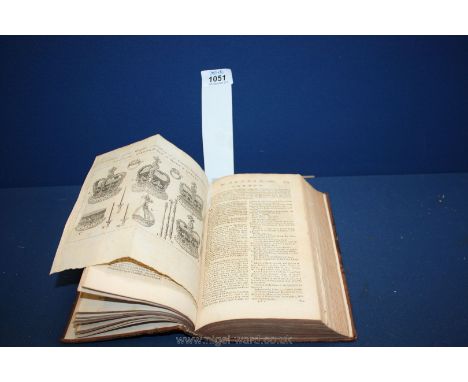
Lot 90
'James I & II, Mary II, William III and Mary Queen of Scots', five 18th century engravings for Mountague's History of England by Charles Grignion after Samuel Wale, 'Cries of London', twelve mezzotints, 'Jamaica', 19th century map by J. Rapkin, pub in John Tallis's Illustrated Atlas and six other prints max 50cm x 64cm (qty)
Lot 241
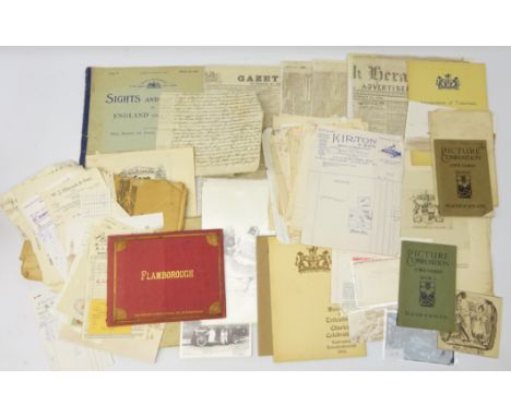
Esso Pictorial Plan of the North, unframed, The Penny Magazine featuring York, 1833, Yorkshire Gazette 1854, The York Herald 1863 & 1835, Yorkshire Gazette 1835, Daily Mail Air- View Map of the Western Front, Flamborough, folio of prints pub. H.S. Webb, 1950s merchant receipts all Hull area, postcards and other ephemera in one box


Lot 3306
Union-Castle shipping line ephemera, stamps, postcards, luggage labels, Route map etc in annotated album, other Cruise Line/ shipping ephemera, Royal Caribbean dinner menu, Troopships luggage labels, other ephemera incl. Bill Beaumont autograph, Tadcaster Tower Brewery Ltd York labels, Hammonds, Bass and other labels etc in one box


Lot 3243
Whellan T.: History and Topography of the City of York. 1857. Two volumes. Rebound in quarter leather; another partially disbound volume two; Bulmer's History, Topography and Directory of North Yorkshire 1890. Re-backed with new end-papers (lacking map); Edwards William: The Early History of the North Riding 1924. Full leather binding; and Elgee's Moorlands of North Eastern Yorkshire (6)


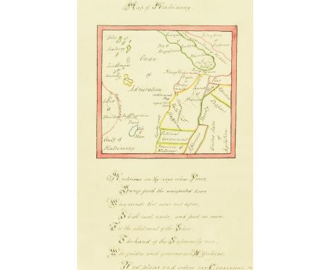
Lot 87
19th-century manuscript Valentine in the form of a 'Map of Matrimony', ink & watercolour, the hand-coloured central design showing countries and oceans as elements of love ('United States of Agitation'; 'Isles of Jealousy'; 'Kingdom of Courtship'; 'Dangerous Strait of Flirtation'; 'Land of Spinsters'), accompanied by handwritten verse, presented in verre eglomise frame, 20cm by 13cm

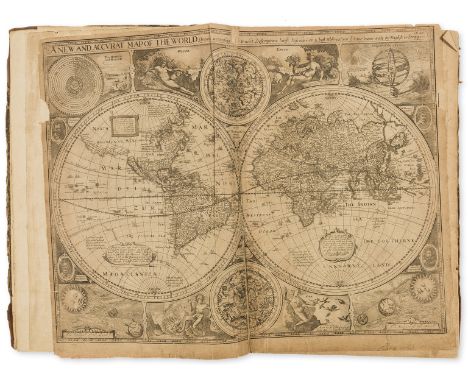
![Cary [John]: 'Cary's New and Correct English Atlas, Being a New Set of County Maps.......', printed by John Cary, engraver an](https://cdn.globalauctionplatform.com/952eecd7-17b3-4ab7-856d-aac000a0024e/25117dde-ab0b-4899-9967-aacc00bbeb74/468x382.jpg)


Lot 193
Canada.- Gray (Hugh) Letters from Canada, first edition, folding engraved map with border hand-coloured, slightly offset, 3 folding tables, contemporary calf, gilt, minor rubbing and scuffs, [Sabin 28393; Goldsmiths' 19842; Kress B.5510], 8vo, 1809.⁂ A fine copy from the library of the Marquess of Headfort with bookplate. Covers the trade, political relations, laws, customs and climate, with particular attention to the commercial importance of Nova Scotia, New Brunswick and Cape Breton.

Lot 223
Voyages.- Campbell (Archibald) A Voyage round the World...in which Japan, Kamschatka, the Aleutian Islands, and the Sandwich Islands, were visited, first edition, half-title, folding engraved map frontispiece with hand-coloured route and wash border, lightly offset, some foxing and browning, contemporary sprinkled calf, spine gilt with red morocco label, a fine copy, [Forbes 448; Hill 244; Howes C-88; Sabin 10210; Streeter sale 2418], 8vo, Edinburgh &c., 1816.⁂ The editor, James Smith's copy, with his bookplate and presentation inscription on half-title to Count Revdin, whose bookplate is also included. The book was published by Smith for the benefit of the author who had lost both his feet to frostbite following the shipwreck of the Eclipse and after a journey along the coast of Alaska in a long boat to Kodiak. He was sent to Hawaii to recuperate, spending over a year there. "The author lived among the chiefs and then with Isaac Davis...His keen firsthand observations on the social structure and agricultural practices of Hawaiians are of great importance." (Forbes).
Lot 191
Atlases.- Speed (John) A Prospect of the Most Famous Parts of the World, 22 double-page engraved maps, Printed by John Dawson for George Humble, 1631; bound with The Theatre of the Empire of Great Britaine, 4 parts in 1, engraved title, dedication and 67 double-page maps, woodcut coats-of-arms, Imprinted at London...to be sold by George Humble, 1627, in Prospect world map with small piece of left border missing and a couple of short tears, one repaired to verso, Bermuda slightly trimmed, title laid down, Theatre lacking portrait (as often) and printed title, Yorkshire West Riding with inset plan of York cut out, Kingdom of England partially hand-coloured, some water-staining, occasional slight worming, affecting various maps, some browning, creases and a few marginal tears and repairs, later half calf, worn, [Chubb XXV; Phillips 442; Skelton, County Atlases 18; STC 23040 and 23043], folio⁂ The first Atlas of the British Isles and the first world Atlas compiled by an Englishman.Provenance: Edward Wallis (inscription on title dated 1791) beneath a trimmed 17th century ownership inscription dated ?1644.
Lot 90
Shenstone (William) The Works in Verse and Prose, 3 vol., first edition, vol.1 and 2 with engraved title-vignette, frontispieces, folding map and 3 vignette head-pieces, occasional foxing and browning, contemporary cat's paw calf, vol.3 in contemporary plain calf with some abrasion to upper cover and slight worming through lower margin throughout, 8vo, 1764-69.⁂ An attractive set from the Cullen House library with bookplates.

Lot 18
Vergilius Maro (Publius) Opera, 5 vol., engraved throughout, one double-page map by Condet, 28 plates or portraits and 54 vignettes by Marco Pitteri, occasional light foxing and browning, contemporary blue morocco, gilt, Wodhull arms to upper covers, spines gilt with red morocco labels (missing 4 volume number leabels), 8vo, Brussels, J.L. de Boubers, 1757-65.⁂ Superb set with a distinguished provenance. Michael Wodhull's copy with his arms to upper covers, signature and acquisition notes (including costs) to front endpapers of vol.1. Later bookplate of William O'Brien. According to Wodhull's note, dated March 29th 1780, his original purchase price was £2.2s.2d and the cost of binding £1.12s.6d.

Lot 190
Atlases.- Seller (John) Atlas Minimus or a Book of Geography, engraved title, frontispiece, double-page world map (with neatly repaired tear) and 49 single-page maps only with facing tables (lacking Biledulgerit ?and Congo, Asiatick Islands and Main India), 3 with verso soiled, Mogul Empire map with small portion of loss to lower margin, 2 maps with early ink ownership inscription to margins, occasional light scattered spotting, some light browning and ink inscriptions to endpapers, contemporary sheep, rebacked, preserving original backstrip, [Wing S2465], 12mo, are sold at his house at the Hermitage in Wapping, and in popes head Alley in Cornhill Lond, [1679]⁂ This copy issued without text, the number of maps is often inconsistent between copies.
-
109182 item(s)/page