![Southern United States ([Lot of 2] Johnson`s Pennsylvania and Virginia [and] County Map of Kentucky and Tennessee), ca. 1862-](http://lot-images.atgmedia.com/SR/36385/2862480/178-2012510161840_468x382.jpg)

Southern United States ([Lot of 2] Johnson`s Pennsylvania and Virginia [and] County Map of Kentucky and Tennessee), ca. 1862-73. x ”. (HC) A. Johnson`s Pennsylvania and Virginia by Johnson & Browning, circa 1862, (22.5 x 16"). This is a map showing Pennsylvania, Maryland, Delaware and Virginia with county boundaries delineated. There is extensive detail of cities, roads, railroads and waterways and an illustration of the city of Baltimore at lower right. Virginia includes the counties of West Virginia, making the map circa 1862 or earlier. Condition - Nice clean image. There are minor separations on the centerfold which have been repaired with tissue on verso. (A) B. County Map of Kentucky and Tennessee by S.A. Mitchell, circa 1873, (21.3 x 14.3"). County boundaries are delineated and there is good detail of roads, railroads, rivers and place names. (A) See descriptions. ()
We found 109198 price guide item(s) matching your search
There are 109198 lots that match your search criteria. Subscribe now to get instant access to the full price guide service.
Click here to subscribe- List
- Grid
-
109198 item(s)/page

Southern United States - Georgia (A Map of Georgia, also the Two Floridas, from the Best Authorities), Thomas and Andrews, Morse`s Universal Geography, Boston, [1796]. 12 x 7.3”. (BW) This is an early American map depicting Georgia Territory extending from the Atlantic seaboard to the Mississippi River, with East and West Florida along the Gulf Coast. Most of the interior is dominated by various Indian tribes, including the Chickasaws, Creeks, Chactaws, and Muskogees with several prominent villages located. Fifteen early counties are shown along the Atlantic coast and the Savannah River. Several trading paths are noted in the west. Mobile, Pensacola and New Orleans are noted. Engraved by Amos Doolittle and published by Thomas & Andrews, Boston. Ref: Wheat & Brun no.614. Issued folding, now pressed with a few small spots and an archivally repaired tear that enters 1/2" into map at top left. (+B)
![Central United States (Louisiana), Ehrmann, Schilderung von Louisiana, Weimar, [1804]. 6.6 x 8.5”. (HC) An interesting](http://lot-images.atgmedia.com/SR/36385/2862480/180-2012510161852_468x382.jpg)
Central United States (Louisiana), Ehrmann, Schilderung von Louisiana, Weimar, [1804]. 6.6 x 8.5”. (HC) An interesting little map showing the Mississippi basin. The United States are labeled Freye Staaten with the frontier showing a huge Indiana, an incompletely formed Kentucki, and Georgia taking in all the region to the Mississippi, including the area of Tennessee. Locates many Indian villages as well as early western forts. Ref: Phillips (Maps) p. 371. Issued folding with light toning in blank margins. (A)

Central United States (The Upper Territories of the United States), Carey, General Atlas…, ca. 1814. 12.5 x 17”. (HC) This early American map focuses on what was then the western frontier. It shows the new territories that had been created from the original Northwestern Territory of the River Ohio - Ohio, Michigan, Indiana, Illinois and the remainder of Northwest Territory (Wisconsin and Minnesota). It shows Chicago in the Northwestern Territory, as the northern Illinois border is shown south of the present-day boundary without touching Lake Michigan. The spurious Phillipeaux Island still persists in Lake Superior. There is excellent detail of the Mississippi River and above to the Lake of the Woods. Detroit is shown with its Canadian neighbor, Windsor, named Sandwich. Numerous frontier forts and Indian villages are located, but much of the territory still appears unsettled. The apocryphal mountain ridges are the most prominent topography on the map. Engraved by Kneass & Delleker. Ref: Karpinski, p. 215, no.27; Phillips (Atlases) no.722-25. Original outline color on watermarked paper with light toning, a few tiny spots, and a small chip in bottom-left corner. There is a short tear that just enters map border at left, and one just outside of neatline at top left, that have both been closed on verso with archival tape. (B)
![Central United States ([Lot of 2] Geological Map of the Middle and Western States [and 22 plates from the Report]), Hall, Geo](http://lot-images.atgmedia.com/SR/36385/2862480/182-201251016191_468x382.jpg)
Central United States ([Lot of 2] Geological Map of the Middle and Western States [and 22 plates from the Report]), Hall, Geology of New York, Part IV...Survey of the Fourth Geological District, New York, [1843]. 32 x 22.5”. (HC) This colorful lithographed geological map, produced by the eminent American geologist James Hall, blends science and the art of cartography. Twenty-three geological formations are named and differentiated using hand applied color. The map covers the region of the United States from its western boundary along the Mississippi River, east to Long Island and the Atlantic. It includes all or parts of Wisconsin, Illinois, Missouri, Kentucky, Virginia, Indiana, Ohio, Michigan, Pennsylvania, New York, New Jersey, Maryland, and Delaware. The lakes Michigan, Huron, Erie and Ontario are shown. Lithographed by Endicott of New York and signed in the plate by James Hall. A very nice example of an early and scarce geological map. Blank verso. This important regional geological map employs the "New York System" of stratigraphic nomenclature developed by Hall and others at the New York Geological Survey. This system emphasized the importance of paleontology for delineating geological units and introduced the concept of "type locality," a primary reference location used for defining the characteristics of geological formations. This map is the first regional application of this new system, which evolved into the standard nomenclature used today for North America and much of the rest of the world. Included with the map are 22 attractive and detailed plates from the disbound report which feature numerous hand colored profile sections of the area, along with many views and images of fossils. Ref: Marcou no.32. The map is very good with narrow side margins as issued, light offsetting, and an edge tear at top that enters 0.5" into the image. The original binding strap is attached at top left. Plates and text are generally good with some scattered foxing. (+B)

Western United States (Map of Upper California by the U.S.Ex.Ex. and Best Authorities 1841), Wilkes, Narrative of the United States Exploring Expedition, Washington D.C., 1841. 11.5 x 8.3”. (HC) This crisply drawn map covers all the American West south of 42 N. and west of the Rocky (Anahuac) Mountains, with by far the greatest detail in California. The cartography is distinctly pre-Fremont. The Sacramento and San Joaquin valleys combine to form the large Buenaventure Valley with the Rio San Buenaventura in the area of today`s Salinas River. The map pre-dates the discovery of gold by several years, but in the vicinity of Sutter`s mill where the settlement of New Helvetica is located. Along the coast the mission towns are named, but there is no mention here of Los Angeles even though it was a self-sustaining farming community as early as 1821. The Colorado River is shown trending in an oddly straight course giving no credit to the Grand Canyon. The Great Basin, called the Great Sandy Plain, is crossed by Smith`s Track and is bounded east and west by the Colorado Range and the California Range. The Great Salt Lake is Youta Lake and the Salt River is called the Inconstant R. Interesting notes explain the unknown qualities of the land and another describe the Indians as "the most miserable objects in creation," an unfortunate depiction. Ref: Wheat (TMW) no.458; Wheat (Gold) 23. Light offsetting with slightly uneven toning and an archivally repaired tear in top blank margin, far from map image. (+B)

Western United States (Western Territories of the United States), Robinson, 1847. 17.5 x 10.5”. (HC) This is a great map showing the transitional boundaries of the American West. Oregon and Washington Territories are massive, stretching all the way from the Pacific to the Rocky Mountains at the Continental Divide. The wide Utah Territory reaches across to a newly formed Kansas Territory, and the huge Nebraska Territory extends from Canada`s border down to Kansas. Minnesota is a large territory as well, which includes a vague Dacotahs region that extends to the Missouri River. A Mormon settlement is noted on the Great Salt Lake - this is one of the earliest maps to note that fact, as Joseph Smith and his followers had just settled in this region in 1847. Original color with toning, some light scattered spots, and the centerfold is reinforced with archival tape. (B)

Western United States (A New Map of the State of California, the Territories of Oregon & Utah), Meyer, Auswanderungs-Atlas fur Nord Amerika, 1852. 12 x 15.3”. (HC) An interesting map of the new state of California and the large western territories based on the important Mitchell series. The map is filled with interesting information, notably, the exploration routes of Lewis and Clark, Fremont, Kearney, and Cooke, and the Spanish and Oregon Trails. Oregon Territory, with Oregon City as its capital, has its eastern boundary in the Rocky Mountains adjoining Missouri Territory. Utah Territory extends to Old Park and Long`s Peak in present-day Colorado. New Mexico Territory encompasses parts of Colorado, Nevada and Arizona and displays a pre-Gadsden Purchase border along the Gila River. Only a few counties are delineated in California and the capital is at San Jose. A large inset shows San Francisco and Environs, which includes much of the Gold Region. It is this unique inset that differentiates this from the Mitchell map. From Meyer’s Auswanderungs-Atlas (Emigration Atlas), this map was targeted to the large number of German immigrants that flooded into the United States in the aftermath of the March Revolution of 1848. A few minor spots, else fine. (A)

Western United States (Map Illustrating the General Geological Features of the Country West of the Mississippi River), Hall, U.S. and Mexican Boundary Survey, Vol. I, New York, [1857]. 23.3 x 20.3”. (HC) This great map of the western United States was one of the first geological maps of the region. It illustrates the many mineral resources that helped spur westward migration and expansion. The legend uses color to identify twelve geological formations. The map is also filled with terrific detail of mountains, watersheds, cities and roads. It covers the country from the Ohio River Valley to the Pacific and extends to include the states of Sonora and Chihuahua in Mexico. The political divisions include the large western territories of Washington, Oregon, Utah, New Mexico, Nebraska and Kansas. Drawn by Thomas Jekyill. Lithographed by Sarony, Major & Knapp, 449 Broadway, New York. Ref: Marcou & Marcou no.52; Wheat [TMW] no.922; Blevins Wyoming no.76. A nice example with bright original color. There is a binding trim at left with a resulting binding tear that extends 2" into the image that has been closed on verso with archival tape and an extraneous crease at lower left that has been reinforced with archival tape on verso. (+B)

Western United States (Map to Illustrate Capt. Bonneville`s Adventures among the Rocky Mountains), Colton, Irving`s Adventures of Captain Bonneville, New York, 1857. 18.6 x 11.6”. (BW) This interesting map is based on Fremont`s map. The region west of the Mississippi to the Pacific Ocean is delineated with the rivers and towns of the gold region in California well shown. The expedition route described is that of Captain Benjamin Bonneville who explored the American West from 1832-1836. The expedition party traveled parallel to the course of the Snake and the Columbia Rivers, going as far as Fort Walla Walla before turning back. Fremont`s route through California is shown, as well as Kearny`s route along the Gila River and the Emigrant route. Published by J.H. Colton, No. 172, William Street, New York. Printed on fine banknote quality paper. There is a tear that extends through the title cartouche that has been repaired on verso with archival tape. Issued folding, the map is lightly toned with a few small spots and extraneous creases. (B)

Western United States (Sketch Indicating the Advancement of the Surveys of the Public Lands and the Military Topographical and Geological Surveys West of the Mississippi), Wheeler, Washington D.C., 1879. 44.3 x 32.5”. (PC) Beautifully lithographed in four colors with impressive detail throughout. The map locates more than 130 forts and camps (many flying tiny American flags), nearly 70 Indian reservations, the routes of dozens of early explorers, completed and projected railroads with their land grants, and dozens of Spanish land grants noted. Survey details plotted include base lines, meridians and townships. Wheeler`s surveying efforts are shown as shaded regions. Map consists of four joined sheets. Ref: Cohen pp. 192-194. The map is clean and bright with a few tiny splits and folds separations that are repaired on verso with archival tape. Issued folding. (+B)

Northwestern United States (Map of the United States Territory of Oregon West of the Rocky Mountains Exhibiting the Various Trading Depots or Forts occupied by the British Hudson Bay Company Connected with the Western and Northwestern Fur Trade), Albert/Hood, Report of the Senate Select Committee on the Occupation of the Oregon Country, Washington D.C., 1838. 20.3 x 17.4”. (HC) This map accompanied an important report intended to awaken public interest in the American occupation of Oregon Territory in the controversy with Great Britain, who also claimed the territory south to the Columbia River. Among the many interesting details are the locations of the various trading posts or forts connected with the American and British northwestern fur trade. The map covers present day Oregon, Washington, Idaho, Montana and Wyoming. The region east of the Rocky Mountains is named Mandan District. It also shows much of southwestern Canada. The map was copied from John Arrowsmith`s 1832 map of British North America. At lower left is the wording of an ultimatum given to the British by Henry Clay, Secretary of State, stating that the 49th parallel will be the boundary. Engraved by M.H. Stansbury. Ref: Claussen & Friis no.221; Hayes no.197; Wheat (TMW) no.434. Clean paper with a bright impression. Issued folding with some light scattered damp staining. (+B)

Northwestern United States, Washington, Oregon (Washington and Oregon), Colton, General Atlas, New York, 1853. 14.8 x 11.8”. (HC) A great map of the Pacific Northwest showing both territories extending to the Continental Divide and incorporating the region that would become Idaho. Of specific interest is the notation of all the major exploration routes, wagon trails and the proposed routes for the transcontinental railway as explored by Gov. Stevens. A few organized counties are confined to a narrow band along the coast and Wascopen, Skamania and Walla Walla are the only counties east of the Cascade Range. Dated 1853 but published circa 1857. There is some damp staining primarily in the left and right margins and a few insignificant edge tears that have been repaired with archival tape on verso. (+B)
![Southwestern United States ([Lot of 2] Military Reconnaissance of the Arkansas, Rio del Norte and Rio Gila… [and] Notes](http://lot-images.atgmedia.com/SR/36385/2862480/199-201251016208_468x382.jpg)
Southwestern United States ([Lot of 2] Military Reconnaissance of the Arkansas, Rio del Norte and Rio Gila… [and] Notes of a Military Reconnaissance, from Fort Leavenworth, in Missouri, to San Diego, in California…), Emory, Washington D.C., 1847-48. 67 x 30”. (BW) A) Military Reconnaissance of the Arkansas, Rio del Norte and Rio Gila, by W.H. Emory, dated 1847, (67" x 30"). An important Mexican-American War period map that shows the route of Col. Kearny and his Army of the West as they traveled from Ft. Leavenworth to Los Angeles via Santa Fe and San Diego. Wheat states that the map was an important milestone in the cartographic development and accurate determination of the geography of the West. Published in Senate Doc no.7, 30th Cong., 1st Session. A large map printed on three sheets, joined as issued. Ref: Wheat [TMW] no.544. Condition: Scattered foxing with numerous short splits at fold intersections and a few light damp stains at left. Folds into attractive contemporary hard blue covers with ribbon tie closures. (C+) B) Notes of a Military Reconnaissance, from Fort Leavenworth, in Missouri, to San Diego, in California..., by W. H. Emory, published 1848, (6" x 9"). This is the Senate edition of Emory`s important report documenting the 1846-1847 journey of the advanced guard of General Kearny`s Army of The West. Emory was Brevet Major of the Corps of Topographical Engineers. Emory`s reports are enjoyable reads and this is no different, with passages such as "I stopped in the little town of Isoletta, to visit my friend, the accolade, who has the reputation, Indian though he be, of being the most honest man and best maker of brandy in the territory." The report summarizes the activity of the U.S. Army of the West after the capture of New Mexico with important early views of the region. It is illustrated with 26 lithographed views, three battle maps, and 14 botanical plates. The important view of San Diego is present. The battle plans are: Sketch of the Actions fought at San Pasqual in Upper California…; Sketch of the Passage of the Rio San Gabriel...; and Sketch of the Battle of Los Angeles Upper California. Fought between the Americans and Mexicans Jany. 9th, 1847. Complete with the two page report (Appendix No. 7) by P. St. Geo. Cooke, Major 2d Dragoons. Printed by Wendell and Van Benthuysen. This is the second edition printed, and thus did not originally contain the large folding map by Emory, which was included in the first and third editions. 416 pages + plates. 8vo, hardbound in brown cloth covers with original paper label on spine. Ref: Wagner & Camp no.148:2. Condition: Moderate to heavy foxing throughout the text with the plates showing only light scattered foxing. Label and covers are very worn. (B) See descriptions. ()

Southwestern United States (Map of the Route Pursued in 1849 by the U.S. Troops, under the Command of Bvt. Lieut. Col. Jno. M. Washington, Governor of New Mexico, in an Expedition Against the Navajos Indians), Simpson/Kern, Navajo Journal, 31st Congress, 1st Session, Senate Exec. Doc. No.64, Washington D.C., 1849. 27.5 x 20”. (BW) This map is the product of a punitive expedition against marauding Navajo Indians. The expedition traveled from Santa Fe to Jemez Pueblo, then on the Navaho trail to Chaco Canyon, and via Washington Pass to Canyon de Chelly. They engaged the Navajo in their strongholds at Chaco Canyon and Canyon de Chelly where the tribe was soundly defeated. The soldiers then explored the area and were the first white men to discover and describe the prehistoric pueblos in the region. The return route traveled south of the Zuni Pueblos and east past Inscription Rock and Laguna Pueblo to the Rio Grande. A seldom seen map that Wheat calls "an arresting production, bringing out many new details of the region." Ref: Wheat (TMW) no.641. There is a 1" binding tear at upper left and a 0.25" edge tear at top left, both of which have been closed on verso with archival tape. The top left corner is chipped, just passing the neatline and there is some light toning primarily along a few folds. Fold intersections have been reinforced with archival tape on verso. (B)

Southwestern United States (Topographical Map of the Road from Fort Smith, Arks. to Santa Fe, N.M. and from Dona Ana N.M. to Fort Smith), Marcy, 31 Cong., 1st Sess, House Ex. Doc No. 45, Washington D.C., [1850]. 27.5 x 14.5”. (BW) This important map is bound in the original and complete report "Route from Fort Smith to Santa Fe. Letter from the Secretary of War" by Capt. R.B. Marcy, 5th U.S. Infantry, made by order of Bvt. Brig. Gen. M. Arbuckle. On the first page the report is forwarded by J.J. Abert, Col. Corps Top. Eng. to Hon. Geo. W. Crawford, Secretary of War and finally to the Hon. Howell Cobb, Speaker of the House of Representatives. This excellent topographical map delineates, for the first time, the region along the Red and Canadian Rivers. It shows two major roads from Fort Smith to Santa Fe, plus several other routes and Indian trails. The map also notes various tribal lands, topography and hydrology as well as the location of daily campsites. It is filled with interesting details and notations including the Apache Trail and Comanche Trail - "Said to be a good route for wagons, with water daily." It includes a very early depiction of Dallas located along the Trinity River. Wheat says "Marcy`s was the first comprehensive map of this area…" Disbound, 89pp, large folding map, and two plates by R. H. Kern, including "View of Santa Fe and Vicinity from the East." Ref: Howes S500, [map] Wheat TMW no.681. Light scattered foxing and toning along the folds. The pages are mostly clean with some scattered light foxing and a few stains on the title page. Map and report are housed in an attractive, contemporary brown clamshell folder. (+B)
![Southwestern United States (Territories of New Mexico and Utah), Colton, General Atlas, New York, [1857]. 14.6 x 11.7”.](http://lot-images.atgmedia.com/SR/36385/2862480/202-2012510162039_468x382.jpg)
Southwestern United States (Territories of New Mexico and Utah), Colton, General Atlas, New York, [1857]. 14.6 x 11.7”. (HC) A very interesting map that depicts the region with the largest extents of Utah and New Mexico territories. Utah Territory encompasses all of today`s Nevada and extends east to the Continental Divide into present-day northern Colorado with Fillmore City as its capital. Kanzas is to the east of Utah Territory. New Mexico Territory stretches between California and Texas and includes part of present-day southern Colorado and the southern tip of Nevada. Fremont`s routes, proposed routes for the Pacific Railroad, and the Spanish Trail are located. This is the fourth state of the map, with the plate number 53 in the lower right corner, with the plain border of the General Atlas indicating it was published in 1857. Text related to California on the verso. Ref: Wheat [TMW] no.832; Brown, Portolan - Spring 2005 pp. 48-51. (A)

Southwestern United States (Johnson`s California Territories of New Mexico and Utah), Johnson & Browning, Illustrated Family Atlas, New York, ca. 1861. 24.5 x 17”. (HC) A very nice example of this early map from Johnson`s Southwest series. The Confederate Territory of Arizona appears in the southern third of New Mexico Territory. Between August 1861 and July 1862, the Confederate General Baylor appointed himself the territorial governor and claimed all of New Mexico Territory south of the 34th Parallel for the Confederacy. The map names the "Gadsden Ten Million Purchase of Mexico" line between the U.S. and Mexico. Nevada Territory makes an early appearance; its boundary with Utah begins near the Great Salt Lake but wanders south-southwest from Lake Sevier. Hastily added to this plate, `Nevada` is crudely fitted in an arc between the U and T of Utah. Filled with historical notations, one note near Quartzite, Arizona refers to the area as being "fertile and abundantly timbered and well watered," which it most certainly is not. The Emigrant Road, the Hastings Road, and the routes of numerous explorers and military expeditions are detailed. The Gold Region of present-day Colorado`s South Park is prominently shown in what was then Kansas. A superb map of the Southwest. Ref: Wheat [TMW] no.1027. Original hand color with a few tiny abrasions near the centerfold, scattered foxing and staining, and light toning. Light soiling in the blank margins. (B)
![Southwestern United States ([Lot of 2] Asher & Adams` Arizona [and] Asher & Adams` Utah), Asher & Adams, New York](http://lot-images.atgmedia.com/SR/36385/2862480/205-2012510162055_468x382.jpg)
Southwestern United States ([Lot of 2] Asher & Adams` Arizona [and] Asher & Adams` Utah), Asher & Adams, New York, 1873. 22.8 x 16.3”. (HC) A. Asher & Adams` Arizona. Double-page map shows an early Arizona with five very large counties that composed the territory of the time. The map displays major rivers, numerous mines, military and Indian reservations, and the progress of public surveys. It also depicts a few key roads and two proposed east-west rail lines that were to cross the territory. A small Navajo Reservation is noted in the northeast corner and Tucson is shown as the territorial capital. B. Asher & Adams` Utah. Another double-page map focused on Utah but including parts of Wyoming, Colorado and Nevada. 18 counties are noted and Salt Lake City is shown as the capital. Development is confined from the Salt Lake area down to the southwest corner along the Salt Lake, Sevier Valley and Pioche Railroad. The completed Central/ Union Pacific Railroad is shown going from Wyoming through Utah into Nevada with some spur lines going into central and northern Utah. Original hand color with just a hint of offsetting on the Arizona sheet and light toning along the centerfold and edges of both sheets. (+B)

Southwestern United States (Report of the Exploring Expedition from Santa Fe, New Mexico, to the Junction of the Green Rivers of the Great Colorado of the West, in 1859…), Macomb, Washington D.C., 1876. 9.5 x 12”. (PC) This important report was produced in 1860 but not issued until 1876 due to the Civil War. Included is the very rare Map of Explorations and Surveys in New Mexico and Utah… (34 x 28.5"), which is considered by Wheat to be a landmark in the mapping of the region and "one of the most beautiful maps every published by the Army." According to Wheat there are several reasons for its importance. First, it is the first to show a trail to the junction of the Green and Grand Rivers. Second, he praises the map for its depiction of numerous routes of other explorers. Finally, it demonstrates the culmination of the process developed by Egloffstein to convey the idea of altitude. The process used a combination of extremely fine lines and applying acid to the plate for varying times, thus giving the map a remarkable 3-dimensional realism unmatched in the period. It is also the first to correctly establish the relationship between the San Juan and Colorado Rivers. The map covers Arizona, Utah, New Mexico and about 30% of Colorado. This highly sought after report is complete with eleven black and white engravings and eleven chromolithograph prints, and also features "Descriptions of the Cretaceous fossils collected on the San Juan Exploring Expedition under Capt. J. N. Macomb, U.S. Engineers." by F. B. Meek. 4to. Complete. Hardbound in brown cloth with gilt title on spine. Ref: Wheat (TMW) no.983. There are a number of fold separations and splits at fold intersections, some of which have been repaired on verso with archival material, including a clean 5" fold separation crossing the title that has not been closed. There is some light toning along folds, minor offsetting, and a few small spots. Text and plates are very good with some light toning and occasional small spots. The covers and spine are worn with the front cover loose and almost detached. The binding is almost perished with some pages separated from text block. (B)
![Alaska ([Lot of 16 - Alaska Maps and Prints]), U.S. Department of Interior, Washington D.C., 1880. x ”. (PC) This lot i](http://lot-images.atgmedia.com/SR/36385/2862480/208-201251016216_468x382.jpg)
Alaska ([Lot of 16 - Alaska Maps and Prints]), U.S. Department of Interior, Washington D.C., 1880. x ”. (PC) This lot includes 2 large maps, 6 smaller maps and 8 colored prints of Alaska which were included in the 10th Census report. The maps were completed by Ivan Petrof, who was the special agent to Alaska for the Census, and includes the topographical Map of Alaska and Adjoining Regions and the ethnographical Map of Alaska and Adjoining Regions…Showing the Distribution of Native Tribes. These two measure 30.5 x 23.7". The 6 smaller maps (9 x 7") focus on the distribution of wildlife across the state including beavers, bears, foxes and minks. The colored prints (7.5 x 5.5"), show various native scenes including "Mahlemute Man and Woman", "Kuskokvagmute Male Summer Dress" and "Beluga Hunter and Dwellings." The two large maps have a few small stains in the image and a few minute splits at fold intersections. The smaller maps and prints are very good with some light even-age toning and an occasional tiny spot. (+B)

California (General Map of Explorations and Surveys In California…), Williamson, U.S. Pacific Railroad Surveys, Washington D.C., 1853. 72 x 24.5”. (BW) Wheat calls this a "monumental document, and is noteworthy that with few exceptions, railroads today follow its `Practicable Railway Routes`." This large and fascinating map depicts the early railroad surveying in California and covers the region from Bodega Bay in the north to below San Diego. The Practicable Route is shown from Ft. Yuma, Arizona to San Francisco and Martinez just across the bay from Benicia. Two parties explored these routes, one led by Lieut. R.S. Williamson and another by Lieut. J.G. Parke. With several parallel routes suggested in most areas, the parties commonly explored the route through the Los Angeles and San Bernardino area. Many towns and missions are located. There is good topographical detail, with some areas noted as not having been "explored instrumentally" while the "size and position are not accurately known" for Tulare Lake.. On two sheets joined, as issued. Ref: Wheat (TMW) no.877. The map has been backed with linen to repair some paper loss along the folds. There are some old tape stains along the folds and some extraneous creasing in the image. (+C)
![California ([Lot of 4 - California Oil]), ca. 1894-1907. x ”. This lot focuses on California oil near the turn of the 2](http://lot-images.atgmedia.com/SR/36385/2862480/212-2012510162120_468x382.jpg)
California ([Lot of 4 - California Oil]), ca. 1894-1907. x ”. This lot focuses on California oil near the turn of the 20th century and includes 1 stock promotional item and 3 books: A. Map of Kern River Oil District, by Standard Consolidated Oil and Land Co., circa 1901, black & white, (7.8 x 10.2"). This promotional map offers stock for sale at a "nominal figure" and promises "immense fortunes" in the Kern River District. According to newspaper reports of the time, it appears that the company didn`t have title to the properties advertised but sold substantial amounts of stock before the perpetrators of the scam disappeared. Condition: Issued folding with a few tiny splits at fold intersections and light toning. (B+) B. The Gas and Petroleum Yielding Formations of the Central Valley of California, by W. L. Watts, published 1894, black & white (6" x 9.3"). 100 pp. with 4 small folding maps and 5 plates. Condition: (A) C. The Santa Clara Valley, Puente Hills and Los Angeles Oil Districts Southern California, by George Homans Eldridge & Ralph Arnold, published 1907, printed color (5.5" x 9). 266 pp. with 41plates and maps including the large Geologic Map of the Santa Clara Valley and Adjacent Oil Fields, Ventura and Los Angeles Counties, California (47.5 x 12.2"). Condition: Plates and maps are very good while the paper covers are chipped with insect damage. (B+) D. Oil and Gas Yielding Formations of California, by W. L. Watts, published 1900, printed color (6" x 9"). 236 pp., numerous illustrations and 14 small folding maps. Maps and plates are generally very good. Covers are somewhat worn and edges are bumped. (B+) See descriptions. ()

California (State of California…), General Land Office, Washington D.C., 1913. 47 x 59”. (PC) This is a superb and very colorful large-scale map of the state printed on two unjoined sheets, each 47 x 29.5 inches. The map shows in great detail the extent of public surveys, hydrology and topography. It also delineates Indian reservations, military posts and reservations, forest reserves, as well as Yosemite and Sequoia National Parks. Completed and proposed railroads are also detailed and named. The top sheet includes inset plans of Los Angeles and San Diego, with a plan of San Francisco and a list of 533 Private Land Grants on the bottom sheet. This is the uncommon large edition that when joined would measure an impressive 47 x 59". Map is clean and bright with a few tiny splits at fold intersections, with some folds reinforced on verso with archival tape. There are some ink notations in the blank margin of the top sheet. (A)

Southern California (Historic Roads to Romance…), 1946. 33 x 22”. (PC) This is a very colorful bird`s-eye view of Southern California. The map covers the counties of San Bernardino, Los Angeles, Orange, Riverside, San Diego, and Imperial. It shows missions, places of interest and historically significant events in the region. Features an attractive border with various vignettes. On the verso is a street map of the city of Santa Ana along with some facts of both the city and Orange County. The map was drawn by Claude G. Putnam. There are a few tiny splits at fold intersections which have been reinforced with archival tape on verso. (A)

San Francisco, California (Plan du Port de St. Francois, Situe sur la Cote de la Californie…), La Perouse, Atlas du Voyage de La Perouse, London, ca. 1798. 9.5 x 14.3”. (HC) This is a reduced version of an uncommon chart that is one of the earliest obtainable maps of San Francisco Bay. La Perouse sailed the California coast in 1786 before setting out for the Philippines on his fateful expedition. His map was based on Dalrymple`s map of 1789 with information derived from Spanish sources including Josef Camacho and Jose de Canizares. The map includes 21 place names, including Alcatraz and the Presidio. Published by G.G. & J. Robinson. Ref: cf. Wagner (NW) no.846. Nice impression on a sturdy sheet with a few tiny creases near the neatline at left and some light, scattered foxing in blank margins. (A)

Berkeley, California (Map of Berkeley and Vicinity), 1912. 22.8 x 23”. (PC) This is a rare single-sided real estate promotional map of the City of Berkeley and surrounding areas issued by Charles Green on behalf of the Newell-Murdoch Company, Real Estate. Key routes, car lines and S.P. lines (presumably Southern Pacific) are highlighted in different colors with Thousand Oaks, Fairmont Park, Arlington Heights, Northbrae, and Regents Park developments north of the city highlighted in green. The map focuses on land tracts (all named) and street layouts with indices to street names and fire alarm boxes given on the left side of the sheet. Important buildings, schools and fire houses are shown (some named in red) as is the University of California campus as it existed in 1912. An attractive map of this well known Bay Area city. Issued folding with some minor soiling and pencil notations in the image and in the bottom margin. (+B)

Los Angeles, California (Street Guide Map of Los Angeles City), 1902. 19 x 21.3”. (BW) This very early advertising pocket map of Los Angeles shows the streets and city blocks of the city with the street car lines shown by bold lines. Elysian Park, Westlake Park and the Los Angeles River are located. Concentric circles are drawn on the map showing the various distances to City Hall. It includes an extensive street index. The map folds into red paper wrappers, which has an advertisement for the Log Angeles National Bank on verso. Compiled, published and copyright by Henry Rueger. The map folds into the booklet "Newman`s Directory Guide and Handbook of Los Angeles and Southern California. Maps and illustrations. Price 25¢." The 106 pp. guide of Los Angeles covers everything imaginable "For Strangers and Residents" plus many unnumbered pages of pictorial advertisements including Cawston Ostrich Farm, Long Beach Bath House, Morosco`s Burbank Theatre, Fremont Hotel and several more. Yellow paper covers, 12mo. Published by T. Newman, 110 N. Broadway, Los Angeles. The population is listed as only 125,000. There are just a few tiny extraneous creases and an edge tear confined to the blank margin. The covers are lightly worn. (A)

Los Angeles, Orange County, California (Map of Los Angeles & Orange Counties Cal.), Chicago, 1914. 28.3 x 26.5”. (PC) Large pocket map of Los Angeles County and Orange County, which folds into original brown paper wrappers. The map is filled with information including railroads, roads, wagon roads, counties, towns and smaller settlements, watershed and topography shown via hachure. There is additional detail of surrounding counties including Ventura, Kern, San Bernardino and Riverside. Published by C.F. Weber & Co. Map is clean and bright with just a few short splits at fold intersections and a hint of toning. Wrappers are lightly worn. (+B)

San Bernardino, California (Map of San Bernardino County Cal.), Chicago, 1914. 39 x 25.5”. (PC) This detailed map of San Bernardino county and vicinity covers the area from Riverside east to Needles and Mohave City. It shows a number of mining districts in the county including Twenty Nine Palms, Trojan, Solo and the Sacramento mining district. Cities, towns, roads and railroads are also displayed. Dissected and backed with linen. Published by C.F. Weber. The map is lightly toned, else fine. (A)

Colorado Springs, Colorado (Birds Eye View of Colorado Springs and Vicinity), Anon., ca. 1900. 17 x 24”. (BW) This rare, anonymous promotional map of Colorado Springs shows a developing city with an impressive view of the Front Range in the background. Colorado Springs was founded in 1871 by William Palmer, a former Civil War General. Palmer was a surveyor for the Kansas Pacific railroad and secured legislation and funding for the Denver & Rio Grande railroad. Palmer thought this area was ideal for a town, and announced Colorado Springs as the route`s first destination out of Denver. As a result of the new infrastructure and the Pike`s Peak gold rush, the city became one of the most popular tourist destinations in the west. Printed on thin, banknote style paper. There are a few short splits at fold intersections and a number of small fold separations, some of which have been repaired on verso with archival tape. (B)

Connecticut (Connecticut), Pease, New York, ca. 1833. 14.3 x 10.8”. (BW) This rare wood-engraved map of Connecticut is surrounded by a decorative border of the 24 state seals that were in existence at the time. Arkansas was next in line to achieve statehood in 1836 and the map reports population data as of the 1830 census, putting the date of this map somewhere in between. The map displays basic detail of towns, cities and counties as well as rivers, lakes and mountains. This unusual map was bound into an annual run of the "Philadelphia Mirror" from July 1836 to July 1837 (56 issues). There are a few small spots in the border, some minor extraneous creasing, and a few archivally repaired tears in the blank margins that just enter map border. (B)
![Washington, D.C. (Plan of the City of Washington), Good, The Literary Magazine and British Review, London, [1793]. 10.5 x 9.5](http://lot-images.atgmedia.com/SR/36385/2862480/225-2012510162215_468x382.jpg)
Washington, D.C. (Plan of the City of Washington), Good, The Literary Magazine and British Review, London, [1793]. 10.5 x 9.5”. (BW) This rare map of Washington DC is based on the small Thackara & Vallance plan produced in March 1792 for `The Universal Asylum And Columbian Magazine`, which is considered the first printed plan of Washington. This British version of the map is chronologically seventh, published a mere 10 months later. The map itself shows a few major buildings including the Capitol and the Presidents House, while others are simply outlined. The proposed landscape design for the Mall is shown with considerably more detail. The rudimentary eagle and shield surrounding the title is the only apparent difference to the Thackara & Vallance map. The map is bound into The Literary Magazine and British Review published in January 1793. This monthly periodical includes a 3-page section discussing the Washington Plan immediately following the map (pp. 49-51). Published by J. Good, Bond Street. 479 pp., hardbound, 8vo, contemporary quarter calf over marbled boards. Ref: Jolly LITB-4; Phillips (M) p. 1004 The map has some light offsetting and a tiny binding tear away from the image. Text has some light scattered foxing and a small damp stain in the first few pages along with a few ink notations. Covers are worn and bumped and the hinges are starting. (+B)
![Black Hills, South Dakota (U. S. Geological and Geographical Survey Of The Black Hills [with] Report on the Mineral Wealth](http://lot-images.atgmedia.com/SR/36385/2862480/226-2012510162218_468x382.jpg)
Black Hills, South Dakota (U. S. Geological and Geographical Survey Of The Black Hills [with] Report on the Mineral Wealth…and Natural Resources of the Black Hills of Dakota), U.S. Department of Interior, Washington D.C., 1875-76. 18 x 16”. (BW) This map shows the Black Hills area which is flanked by the North and South Forks of the Cheyenne River. There is incredible detail of relief through hachure and many elevation points are noted. There is a note at bottom left that identifies gold districts including Bear Lodge Range and the Elk, Box Elder and Spring creeks to name a few. Included with the map is a 71 pp. report by Walter Jenney that describes the recently-discovered gold occurrences and early mining operations in the area. This report corroborated an earlier account of gold by G.A. Custer in 1874. Jenney`s map and report were released in 1876 and caused a massive rush of prospectors and immigrants to the region, which was considered sacred land by the Sioux. This influx of people led to the Great Sioux War of 1876-77 and the demise of Custer at Little Bighorn. A scarce and important report. Ref: Wheat no.1264. Condition code is for the map. There is just a hint of toning along the folds, else fine. The report is disbound and the pages have a hint of toning. (A)

Florida (Carte des Costes de la Floride Francoise…), Bellin, Charlevoix`s Histoire et Description de la Nouvelle France, Paris, [1744]. 5.8 x 8.3”. (BW) This map shows the coast from Cape Fear south to St. Augustine and locates the English, French and Spanish settlements along the coastline. There are a number of cartographic errors, including the incorrect positions of James Town and Charles Town which are labeled as neighboring towns. Ref: Cumming no.259 There is some light offsetting and a binding trim at lower left with minor loss of neatline. Issued folding. (+B)

Florida (North America XIV Florida), SDUK Society for the Diffusion of Useful Knowledge, London, 1834. 12 x 16”. (HC) Early and very detailed, steel engraved map of Florida that was published eleven years before statehood. The western panhandle, from Apalachicola to the Perdido River, is shown in an inset on the same scale. South Florida is virtually empty of settlement, but is bisected by a long Indian Path. A large reservation for the Seminole Indians takes in much of the interior of the peninsula and the region around Charlotte Harbor. Lake Okeechobee (here Lake Macaco) is incorrectly located, which is a common error on maps of this period because the region was largely unexplored. The first railroad was chartered three years before this map was issued, but we find no mention of it here. An early map of Florida, published by Baldwin & Cradock. Light soiling and toning with two small edge tears at bottom that just enter the map image and have been closed on verso with archival materials. (+B)

Florida (Granville`s Railroad and Township Map of Florida), 1887. 14 x 19”. (PC) This map shows the entire state of Florida delineated by county. Both existing and proposed railroads are displayed including the Florida Southern, Florida Western and Nashville railroads. At left is an inset of the panhandle and below that is a comprehensive index to places. The verso contains 10 panels with facts about the state as well as advertisements for the Mallory Steamship Line with service from New York to "Every Point in Florida." Published by Charles Granville. Issued folding with numerous fold separations and a few areas of minor loss at fold intersections have been closed on verso with archival tape. There is some minor extraneous creasing in the map image and a hint of toning along a few folds. (B)
![Florida ([Map of Florida] Southern Railway System), Poole Bros., Chicago, 1915. 17 x 28.3”. (PC) The Southern Railway s](http://lot-images.atgmedia.com/SR/36385/2862480/231-2012510162238_468x382.jpg)
Florida ([Map of Florida] Southern Railway System), Poole Bros., Chicago, 1915. 17 x 28.3”. (PC) The Southern Railway system was formally created in 1894 and was a product of nearly 150 predecessor lines across the southern United States. This map, catering to the burgeoning tourist industry in Florida, shows the extensive network of railroad lines operating in the state. In addition to the detailed map, there are insets of Cuba and the Southeast U.S. showing railway connections. On the verso is an index to cities and resorts in Florida. Folds into blue stiff paper covers measuring 4.5 x 9.3". There are a few short splits at fold intersections, else very good. The covers are lightly worn and sunned. (+B)

Southern Florida, Bahamas, Cuba (A Chart of the Gulf of Florida or New Bahama Channel, Commonly Called the Gulf Passage…), Faden, London, 1794. 29 x 23”. (HC) This chart was completed by Charles Roberts, Master of the Royal Navy, and is based on the work of George Gauld, a Scottish surveyor. Gauld was assigned by British Admiralty to chart the waters off the Gulf Coast from Louisiana to the Bahamas. He arrived in the Florida area in 1764 on the English ship Tartar, along with John Harrison’s son. William Harrison was on board to test his father`s clock Number Four, which was designed to determine longitude at sea. Although Harrison returned to England soon after arriving in Barbados, his longitude measurements were determined to be accurate to two minutes, or two miles. This data aided Gauld in creating extremely accurate charts. Realizing the importance of his work, Gauld began sharing manuscript charts of his early work with scientific societies in America. The Revolutionary War forced Gauld to suspend his work due to attacks by American privateers, and he was taken prisoner in 1781 and repatriated to England, where he died. This rare sea chart depicts southern Florida, the Keys, the Bahamas, and the northern coast of Cuba. Extensive detail of soundings, shoals, navigational hazards, safe anchorages, and wind and water currents is shown. Seven coastal views are depicted in Cuba, and a small inset shows enlarged detail of the islands from Nassau to Booby Rocks. A table with the longitudes and latitudes of various locations fills the top right corner. This map was published by William Faden, who published many of Gauld`s charts. Original outline color with toning, minor offsetting, and light scattered foxing at top. There is a clean centerfold separation that enters 2.5" into map at top, a tear that enters 1/2" into map at top of the cartouche, and several small chips and tears in blank margins, not affecting map. (B)

St. Augustine, Florida (A View of the Town and Castle of St. Augustine, and the English Camp before it June 20, 1740), Silver, An Impartial Account of the Late Expedition against St. Augustine…, London, [1742]. 6.6 x 11.7”. (HC) This is a depiction of British General John Oglethorpe`s first unsuccessful expedition against the Spanish at St. Augustine. The bird`s-eye view depicts the Matanza River, the castle, the North and South Channel and warships in the foreground. A lengthy key and explanatory notes fill the bottom third of map. General Oglethorpe was the founder of the American colony of Georgia, which was situated as a buffer colony between Spanish Florida and South Carolina. Size includes the key and text. Ref: Jolly GENT-12. There is a hint of toning and faint abrasions. (+B)
![Pensacola, Florida ([Lot of 2] Plan de la Baye de Pansacola [and] Pensacola Harbour), ca. 1744-1833. x ”. (BW) A. Plan](http://lot-images.atgmedia.com/SR/36385/2862480/234-2012510162246_468x382.jpg)
Pensacola, Florida ([Lot of 2] Plan de la Baye de Pansacola [and] Pensacola Harbour), ca. 1744-1833. x ”. (BW) A. Plan de la Baye de Pansacola, by Jacques Nicolas Bellin, from Charlevoix`s Histoire et Description de la Nouvelle France, dated 1744, (11" x 7.8"). An early chart of Pensacola Harbor, showing the locations of forts St. Charles and St. Rose, as well as soundings and anchorages. This example was engraved from maps and charts brought back to Paris by Pierre Francois Xavier de Charlevoix (1682-1761), a Jesuit historian who explored the Great Lakes, and the Mississippi River Basin from 1721-22. He was shipwrecked near Pensacola on his way to New Orleans. His detailed notes and scientific observations enlivened the memoir on the explorations, Histoire et Description de la Nouvelle France. The map was engraved by Dheulland in Paris under the direction of Jacques Nicolas Bellin and published in 1744. Condition: Light offsetting with a binding trim at lower right with minute loss of neatline. Issued folding. (B+) B. Pensacola Harbour, by Edmund Blunt, circa 1833, (8" x 10"). Surveyed by Major Kearney, this chart showing numerous soundings in the Harbor, as well as a tiny Pensacola and Rosa Island. Condition: There are a few minor extraneous creases and a few tiny spots. Issued folding. (B+) See description. ()
![Hawaii (Chart of the Sandwich Islands), Cook, A Voyage to the Pacific Ocean, London, [1785]. 18.3 x 11”. (HC) Although](http://lot-images.atgmedia.com/SR/36385/2862480/237-201251016230_468x382.jpg)
Hawaii (Chart of the Sandwich Islands), Cook, A Voyage to the Pacific Ocean, London, [1785]. 18.3 x 11”. (HC) Although the first printed map of Hawaii is credited to Captain James Cook, it was prepared for publication by Lieutenant Henry Roberts, who prepared all of the maps for the three-volume narrative of Cook`s final voyage. Roberts drew the map from a now-missing survey by William Bligh (of Mutiny on the Bounty fame) who was Sailing Master on the HMS Resolution. The map is a landmark in Hawaiian cartography and provided the basis for all subsequent mapping of the islands. The routes of the Resolution and the Discovery around the islands are carefully traced with nice topographical detail on each island. A large inset of Karakakooa Bay (Kealakekua Bay) is featured with details of soundings, navigational hazards and the anchorages of the two ships, and quaint depictions of houses, palm trees, and fields inland. Cook spent his last few weeks in Kealakekua Bay before dying in a confrontation with natives on February 14, 1779. Engraved by William Harrison and published by Nicol and Cadell. Ref: Fitzpatrick, pp. 15-18, plt. 2. Issued folding, now pressed. Attractive color with a few insignificant spots and minor creasing. There are a couple of short tears in blank margins that have been archivally repaired. (+B)

Oahu, Hawaii (Oahu Hawaiian Islands), 1881. 34.8 x 26.5”. (PC) This large, detailed and attractively colored lithographic map was produced 17 years before the U.S. annexation of Hawaii in 1898. It shows the various Crown lands reserved for Kamehameha III (colored yellow) which were transferred by descent, conveyance, and legislation to the public domain as designated in the division of 1848. Government lands are shown in green. Relief is shown by hachure with towns, churches, roads and trails noted. Surveyed by W.D. Alexander. This is one of the first maps published by the Hawaiian Government Survey, which was established in 1878. A reduced version of this map appears in the 1883 U.S. Geological Survey. Issued folding with a few tiny spots in the image, one tiny split at a fold intersection, and a narrow, but adequate, left margin. (+B)
![Chicago, Illinois ([Lot of 2] Map of the City of Chicago [and] Atlas of Illinois Counties of Cook, Du Page, Kane Kendall and](http://lot-images.atgmedia.com/SR/36385/2862480/243-2012510162327_468x382.jpg)
Chicago, Illinois ([Lot of 2] Map of the City of Chicago [and] Atlas of Illinois Counties of Cook, Du Page, Kane Kendall and Will…), Warner & Beers, Chicago, ca. 1875. 13.8 x 16.8”. (HC) This lot includes two maps of Chicago and the surrounding area. The post-fire Chicago map displays good detail of streets, railroads, parks and wards. The second map shows the extensive railroad network converging on the city once Chicago had established itself as the central distribution hub of the nation. Both maps are surrounded by a decorative scroll border. There are a few faint spots and minor soiling. (+B)

Indiana (Map of the Wabash & Erie Canal Line from the Mouth of Tippecanoe to Terre-Haute as Surveyed by Charles T. Whippo [with HR report]), U.S. Government, HR Doc. no.32, 25th Congress, 3d Session, Washington D.C., ca. 1838. 10.3 x 12.5”. (HC) This interesting small map is accompanied by the 49 pp. Congressional report. The 1838 document regards the grant of a tract of land to the State of Indiana for the purpose of opening a canal to connect the Wabash River with Lake Erie. The proposed canal is lightly colored pink. The Wabash-Erie Canal was completed in 1842. It extended to Evansville, rather than Terre Haute, as shown on this map. The map has offsetting and is trimmed to neatline for binding on the left. The report pages have scattered foxing and about 16 pages are toned. (B)
![Indiana ([Lot of 2] A New Map of Indiana with its Roads & Distances [and] A New Map of Indiana with its Roads & Dista](http://lot-images.atgmedia.com/SR/36385/2862480/245-2012510162331_468x382.jpg)
Indiana ([Lot of 2] A New Map of Indiana with its Roads & Distances [and] A New Map of Indiana with its Roads & Distances), ca. 1841-50. 11.5 x 14”. (HC) This lot contains two versions of the map of Indiana; first issued by Tanner in 1841 and then reissued by Mitchell in circa 1850. They provide an excellent view of the development of the state in the mid-nineteenth century with early county development and an expanded transportation network. There is good detail throughout locating numerous towns, villages, railroads, canals and rivers. The map clearly shows the National Road cutting across the middle of the state and the Old Indian Boundary is still noted in the northeast corner of the state. At left there is a table that gives the steamboat routes from Louisville to Pittsburgh and from Louisville to New Orleans. At right is a profile of the Wabash and Erie Canal. Maps are mostly clean and bright with a hint of toning and a few occasional spots. (+B)

Iowa (Iowa), Tanner, New Universal Atlas, Philadelphia, ca. 1845. 12.8 x 15”. (HC) This great map of Iowa Territory depicts 31 counties clustered along the Mississippi River in the southeast. There are a number of early settlements (many of which no longer exist) and roads depicted in this region. The majority of the territory is divided among Indian nations; the Sioux in the north, and the Sauks and Foxes, Iowas and Pottawattamies in the south - separated by a large swath through the middle labeled Neutral Ground. County development is current to 1843. The map was published by Carey & Hart just prior to Iowa`s admission as a state. Original color with light soiling and toning primarily in the blank margins. (+B)
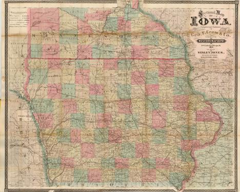
Iowa (Sectional Map of Iowa…), Cram, Chicago, 1871. 32.3 x 26.8”. (HC) This uncommon pocket map is highly detailed and filled with information including watershed, towns and early settlements, and wagon roads. It is colored by county with the county seat identified. The railway system is well developed throughout the state. The map carries the date of 1871 with a copyright date of 1869. The imprint is Cram`s Western Map Depot, 148 Lake St. Chicago, Ill. The map folds into original brown cloth boards with fancy embossed pattern and gilt title. Paper label on inside cover is the "Official Census of Iowa, 1870" and includes 3 pp. of population data. Ref: Rumsey no.3160.002 There is light toning along folds, and a few small separations and areas of loss along folds which have been closed on verso with archival materials. Narrow top and bottom margin, as issued. (B)

Kansas Territory (Sketch of the Country Near the Southern Boundary of Kansas), U.S. War Department, HR Doc no.103, 35th Congress, 1st Session, Washington D.C., [1858]. 48 x 21”. (BW) This map describes the important survey that established the southern boundary of Kansas Territory and the feasibility for a southern railroad route. The survey was conducted by Col. Joseph E. Johnson with the map drawn by his assistant, J.E. Weyss. It covers the region from Neosho, Missouri to Albuquerque, New Mexico and includes topographic features and good detail. It locates forts, identifies the Santa Fe Trail as the Santa Fe Road, shows the route of Lt. Whipple in 1853, Aubrey`s Trail (an important cattle trail), and names Old Fort Scott, Ft. Union, Raton Pass and Santa Fe. At bottom is a profile of elevations by Dr. Wizlizenus. The map is accompanied with the original, disbound, three-page report "Southern Boundary Line of Kansas. Letter from the Secretary of War, Transmitting The report of Colonel Johnston`s survey of the southern boundary line of Kansas," dated April 15, 1858. A historically important map complete with its short report. Ref: Wagner & Camp no.301a; Rittenhouse (The Santa Fe Trail) no.330. There is a 2" binding tear at left that is closed on verso with archival tape and a few tiny splits at fold intersections. Issued folding. (+B)

Kentucky (Kentucky), Bradford, Boston, ca. 1835. 10 x 7.8”. (HC) This lovely map of Kentucky shows nearly up-to-date county development. The map includes the newly formed Marion County but does not show Clinton County. The map details the topography, rivers, towns and settlements. Original color. (A)

Tennessee (The State of Tennessee), Carey, General Atlas…, Philadelphia, ca. 1814. 20.8 x 9.8”. (HC) This fine map of Tennessee shows the state at an early point in its development with only twelve organized counties in the Mero and Washington Districts. The majority of the state is shown to be Cherokee tribal territory. The map depicts a few settlements, forts, trails, and roads, two of which venture out into Cherokee country toward the Tennessee River. This map lacks the engraved "22" plate mark above the neatline, and could possibly represent an unrecorded first state of the map which first appeared in Carey`s General Atlas in 1814. Good impression and original outline color with light toning centerfold and scattered foxing. (+B)
![Tennessee, Civil War ([Lot of 9 - Civil War in Tennessee]), Ruger, History of the Army of the Cumberland, [1875]. x ”.](http://lot-images.atgmedia.com/SR/36385/2862480/252-2012510162354_468x382.jpg)
Tennessee, Civil War ([Lot of 9 - Civil War in Tennessee]), Ruger, History of the Army of the Cumberland, [1875]. x ”. (PC) Included are nine maps by Edward Ruger illustrating the various Civil War battles in Tennessee from the atlas of Van Horne`s "History of the Army of the Cumberland." Ruger worked for the Topographical Engineers and had access to the War Department maps and plans, which he used in the production of these finely detailed and well engraved maps. Each shows highly detailed troop actions and movements with color overprinting. Published by Robert Clarke & Co., and printed by the Krebs Lithographing Co., Cincinnati. A. Map Exhibiting the Campaigns of the Army of the Cumberland…, (17.3" x 14.5"). Condition: Two tiny splits at fold intersections and a 0.5" edge tear that has been repaired on verso with archival tape.. (B+) B. Map Exhibiting the Chattanooga & East Tennessee Campaigns in Conjunction, (18" x 16.5"). Condition: There are 2" and 5" fold separations that have been partially repaired on verso with archival tape. Binding trim at upper right. (B) C. Map of the Field of Shiloh…, (5" x 8.3"). Condition: (A). D. Map of the Battlefields in Front of Nashville, (8.8" x 8"). Condition: (A). E. Battlefield of Chattanooga With The Operations of the National Forces… , (8" x 9.5"). Condition: Binding trim at lower left. (B+) F. Battlefield in Front of Franklin, Tenn., (5" x 8"). Condition: (A). G. Map of the Battlefield of Stone River, (5" x 8.1"). Condition: (A). H. Map of the Battle of Chickamauga, (8" x 5"). Condition: (A). I. Map of the Country Between Monteret, Tenn. And Corith, Miss. … , (6.5" x 8"). Condition: (A). See descriptions. Larger sheets are issued folding. ()
![Maine ([Lot of 2] Map of the Northern Part of the State of Maine and the Adjacent British Provinces… [and] Extract from](http://lot-images.atgmedia.com/SR/36385/2862480/253-2012510162359_468x382.jpg)
Maine ([Lot of 2] Map of the Northern Part of the State of Maine and the Adjacent British Provinces… [and] Extract from a Map of the British and French Dominions in the North America by Jno. Mitchell), U.S. Government, Sen. Doc. 502, 25th Cong., 2nd Sess., [1838]. 16.5 x 15.3”. (HC) The first map details the boundary dispute between the United States and Great Britain relating to Maine. Hand coloring is used to show the boundary as claimed by the United States and by Great Britain, with a third line labeled "that of the Arbiter" which closely corresponds to Maine`s present-day border with Canada. A table gives the major points of contention in this border dispute. Another table names land grants belonging to six land holders. The second map (13.3 x 13") was included in the same Senate report for historical purposes. It was extracted from Mitchell`s map of 1755 by W.J. Stone. Both maps are still bound into the original 16 pp. report. Ref: Claussen & Friis no.223; Phillips (M) p. 384. Map of the Northern Part... has light offsetting and a hint of toning with a binding trim at left. Extract from a Map... also has light offsetting and toning with a binding tear at right that extends 0.5" into the image. Both issued folding. (+B)

Maine (Colton`s Maine), Colton, New York, 1865. 12.4 x 15.7”. (HC) This pocket map individually colors each of the counties and depicts roads, towns and villages, rivers, railroads and topography. County boundaries are current to 1860, showing 16 counties. Printed on fine banknote quality paper, the map is surrounded with Colton`s trademark strapwork border. Folds into 3.5" x 5" embossed and gilt green cloth boards. The original paper label on the inside front cover advertises Colton`s other maps and atlases. There are a few tiny spots in the image and a small chip at left, confined to the blank margin. A few fold intersections are reinforced on verso with archival tape. (+B)

Maryland (Map Showing the General Location of the Natural Oyster Grounds of Maryland…), U.S. Government, Bulletin of the United States Fish Commission, Washington D.C., 1893. 22 x 35”. (PC) This colorful chart details oyster fishing beds throughout Chesapeake Bay and part of Chincoteague Bay in remarkably fine detail. The map locates Washington, D.C., Annapolis, Baltimore and Philadelphia in street grid pattern. It locates areas where oyster gathering is authorized, and by which method, as shown by the color coded key at upper left. By the 1870`s, Maryland`s oyster fields were becoming severely depleted, which led to oyster management efforts in the form of laws and regulations. This informative map is from one of the reports of that effort. Folding, as issued, with beautiful bright color. The map is in near fine condition with only a few tiny splits at fold intersections. (A)

Massachusetts (The State of Massachusetts. Compiled from the Best Authorities), Lewis/Carey, Guthries Geography Improved, Philadelphia, ca. 1800. 18.8 x 14.1”. (HC) This early map of Massachusetts illustrates the hills, streams, ponds and lakes, county boundaries, main roads, and towns. It extends to include Martha`s Vineyard and Nantucket. An early survey marker, Station Trees, is located just north of Dracut at the New Hampshire border with two tiny trees engraved at that point. This is the second state with the page number 28 at upper right. Ref: Wheat & Brun no.213. Lightly toned. (+B)

Boston, Massachusetts (Boston and Surroundings), Walker Lithograpic & Publishing Co., Boston, ca. 1910. 27 x 41”. (PC) This is a large format folding map of the greater Boston area. It is highly detailed showing street names, bridges, railroads, parks and docks. Published by the Walker Lithographic & Publishing Co., 400 Newbury St, Boston on behalf of the New England News Company. Folds into tan paper wrappers measuring 4 x 8". Bright and clean example with a few small splits at fold intersections and light toning where the map folds into its wrappers. Front wrapper is detached. (+B)

Boston, Massachusetts (The Town of Boston 1798), Anon., ca. 1930. 20 x 13.5”. (PC) This colorful pictorial map shows the city of Boston surrounded by the Charles River and Boston Harbor. Six vignettes are shown on the sides of the map depicting historically significant events including John Hancock`s inauguration as the first governor of the state, Joseph Warren`s address, and the Boston Tea Party. There is a small tear along Mill Dam, an archivally repaired tear that just enters neatline at lower right, a few faint spots, and one tiny abrasion in the lower blank margin. (B)
![Cape Cod, Massachusetts ([Lot of 2] Map of Cape Cod and Vicinity [and] Automobile Map of Massachusetts. Cape Cod), Walker Lit](http://lot-images.atgmedia.com/SR/36385/2862480/264-2012510162447_468x382.jpg)
Cape Cod, Massachusetts ([Lot of 2] Map of Cape Cod and Vicinity [and] Automobile Map of Massachusetts. Cape Cod), Walker Lithograpic & Publishing Co., Boston, ca. 1900-08. x ”. (PC) This lot features two automobile maps of the Cape Cod area including Nantucket and Martha`s Vineyard, both published by the Walker Lithographic & Publishing company. The maps display the "best" highway routes in red and show numerous other roads, railroads and abundant coastline. Both maps are dissected and mounted onto linen with brown paper labels. A. Map of Cape Cod and Vicinity, circa 1900, (18.5" x 20.5"). Condition: Light toning and a few minor spots, else very good. (B+) B. Automobile Map of Massachusetts. Cape Cod, dated 1908, (29" x 30.8"). Condition: The map is toned and the linen is partially separated along a few of the fold intersections. (B) See descriptions. ()

Missouri (No. 3 Map of the Harbor of St. Louis, Mississippi River), U.S. Army, Senate Doc. no.139, 25th Congress, 2nd Session, Washington D.C., 1837. 42 x 16.6”. (BW) Robert E. Lee surveyed and produced three maps of the Mississippi River in 1837. This one, joined on two sheets, covers that portion of the river in the vicinity of St. Louis and includes a street plat of the city (with some streets named). It locates stone quarries, lime kilns, Indian mounds, etc. The islands of Cascarot (partial), Bloody, Duncan`s and part of Cahoe are shown. There are proposed dikes and revetments to improve the harbor. A cross-section of a typical dyke is illustrated. Finely drawn by Lee, it contains very good detail of the area. Just a hint of offsetting and toning, else fine. (A)
-
109198 item(s)/page