We found 109182 price guide item(s) matching your search
There are 109182 lots that match your search criteria. Subscribe now to get instant access to the full price guide service.
Click here to subscribe- List
- Grid
-
109182 item(s)/page


Lot 10
John Chapman and Peter Andre,Map of the County of Essex From an Actual Survey Taken in 1772 and 1773,With 25 maps dated 1777, 1st edn. large folio, loose in a folder. A couple torn; title page torn with small loss; couple of maps with browning, the rest are very clean. Sold as a collection of plates not subject to return
Lot 113
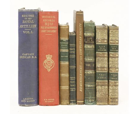
MILITARY AND NAVAL:1. The Navy List, 20 September 1842. L, W Clowes. pp186; full leather with gilt decorations to covers and aeg. VG+;2. Dalton, C: The Waterloo Roll Call. L, W Clowes, 1890; pp256 and four portraits; full leather. VG+;3. Lewin, Major Ross: The Life of A Soldier. A Narrative of twenty-seven years' service in various parts of the world; in three volumes. L, R Bentley, 1834, volume 2,1st edn. (with an extra folding map and a couple of plates, tipped-in; also slightly larger and in different binding); volumes 1 and 3, 2nd edn. Half leather. Little worn and with some pencil notes;4. Swiney, Colonel G C: Historical Records of the 32nd (Cornwall) Light Infantry, now the 1st Battalion Duke of Cornwall's Light Infantry. From the formation of the Regiment in 1702 down to 1892. L, Simpkin, Marshall. 1893, 1st edn. Inscribed and signed by author to captain Lowe, R A 16 plates (10colour) and other illustrations. Original red cloth, gilt. Corrections and notes i

Lot 117
TRAVEL, ETC:1. Smyth, Lieutenant W; and Lowe, F: Narrative of a Journey from Lima to Para, across the Andes and down the Amazon. L, J Murray, 1836, 1st edn. 8vo. Illustrated with 11 plates and 2 folding maps. Original covers. Worn and detached; spine chipped with loss; heavy foxing to few plates;2. Albin, John: A Companion to the Isle of Wight. Printed for the author, 1818, 8th edn. with considerable additions; pp115. Plus a large folding map, dated 1807. Contemporary full leather. Covers little worn; the map with a couple of tears to the folds; o/w VG;3. Tape Indicator Map of London. C Smith, nd, map dated: 16 July 1888; pp55, linen backed coloured folding map, and the tape. Original covers. G+;4. Raja Udaji Rao Puar of Dhar: Driving In India. Bombay, Times press, 1911, 1st edn. Presentation copy from the author, dated 17 December 1925. Illustrated. Original cloth, gilt. VG (4)


Lot 126
FOREIGN TRAVEL/BINDING:1. Urquhart, David: The Spirit of the East; or, Pictures of Eastern Travel. Two volumes bound in one. L, H Colburn, nd, (c.1858) 2nd edn. plates dated 1857, with two colour lithographed plates and a folding map. Title page to volume 1 and only half title to volume 2. Full leather. Covers little scuffed; inscription and to front endpaper; o/w VG;2. West, Mrs (Jane): Poems and Plays. Two volumes only of ? L, T N Longman and O Rees, 1799. Contemporary full leather. Covers little worn; top corners of title pages cut out;3. Plus four other bindings (7)
Lot 138
WALKER, John and Charles:Hobson's Fox-Hunting Atlas: Containing Separate Maps of Every County in England and the Three Ridings of Yorkshire,With 42 hand-coloured double-page maps; showing roads, railways, canals, parks, etc. L, J & C Walder, nd, c.1860. Folio, half leather. Covers worn and hinges cracked; one map with a tear to fold; light foxing/browning to fold of first few maps; o/w VG

Lot 140
OWEN, John and BOWEN, Emanuel:Britannia Depicta or Ogilby improv'd; Being a Correct Copy of Mr Ogilby's Actual Survey of All Ye Direct & Principal Cross Roads in England and Wales...,L, printed for and sold by Tho: Bowles Print & Map Seller Next ye Chapter House in St Pauls Church-Yard & Em Bowen next ye King of Spain in Katherins, 1720, 1st edn. pp: engraved title within ornamental border, (iv)table, 273 engraved county and road maps, 8vo. Contemporary calf, rebacked with new spine; covers worn and chipped; the occasional small stain; o/w G+

Lot 141
SPORTING:1. Allen, John: Principles of Modern Riding for Ladies. L, Thomas Tegg, 1825, 1st edn.?; with 23 plates; pp(xv), 192, and (iv)advert for the London Enclyclopaedia, bound at the front. Original papered boards and cloth spine. Inner hinges cracked; occasional foxing; o/w G+;2. Nimrod, Charles James Apperley: The Life of John Mytton, Esq, of Halston, Shropshire. L, Routledge, 1870, 4th edn. with 18 colour plates. Rebound in plain cloth, with the original front preserved, occasional foxing; o/w G+;3. Simpson, C: Leicestershire & Its Hunts. 1926, 1st 4to. folding map and colour plates. Original cloth, little worn; occasional foxing (3)


Lot 157
ANTIQUARIAN/BINDING:1. Voltaire: Letters concerning the English Nation. L, C Davis, 1741, 2nd edn. pp255 and index, and(vii)catalogue. Contemporary full leather. Covers worn; few pencil notes; bookplate of Lord Wenman to front pastedown; o/w G;2. Voltaire: Histoire de Charles XII. L, C Davis, 1740, 7th edn. Illustrated with frontis plus folding map; ppxiii, 325; and index. Contemporary full leather. Covers worn; few pencil notes; bookplate of Lord Wenman to front pastedown; o/w G;3. Lockman, John: A New Roman History, by Question and Answer. L, T Astley, 1737, 1st edn. ppxciv, 342 and index, and (iv)catalogue. Contemporary full leather. Worn; o/w G;4. The book of family crests. In two volumes. H Washbourne, 1845, 5th edn. With 108 plates. Contemporary full leather. Little worn; o/w VG;5. Mémoires de J Casanova. In eight volumes. Paris, Garnier, nd. Half leather. VG set;6. Plus sixteen leather bound books (29)

Lot 163
PLATE BOOKS, ETC, INCLUDING:1. (Pennant, Thomas): Some Account of London. 1793, 3rd edn. All plates present, including folding map. Full leather. Worn and covers detached; map with tears to folds;2. Old Poor Robin: A collection of eleven almanacs. 1782-1792, each year in two parts, bound in one full leather volume. 1785-1792 complete. The rest lacking mostly the title page;3. The Lady's Monthly Museum. 1804, with hand-coloured plates. Covers worn;4. Naval Chronicle. With eleven plates and folding map. Lacking the title page and one plate; A/F;5. The Complete magazine of knowledge and pleasure, volume 1. 1764. With two maps and two plates;6. Taylor, I: Scenes in Africa. 1821, folding map and many plates; a folder of mostly 19th century engravings;7. Plus four others (11)

Lot 185
HERTFORDSHIRE:1. Salmon, Nathaniel: History of Hertfordshire: Describing the County, and its Monuments. London: no publisher, 1728, 1st edn. Folio, pp:title page, (ii) subscribers’ list, (iv) dedication, 369; with a folding map. Contemporary full leather with 19th century spine and the bookplate of A Acland. Occasional foxing and browning; o/w VG;2. Hertfordshire: Extracted from Cox's Magna Britannia. c.1720, with a folding map and pp965-1042. Leather backed marbled boards. Occasional foxing; o/w VG;3. Inventory Of The Historical Monuments In Hertfordshire. HMSO, 1910, 1st 4to. Folding map and plates. Occasional foxing; o/w VG;4. Topographical and Statistical Description of the County of: Middlesex; Essex; and Hertford. Three volumes in one. C Cooke, nd, c.1820. With three folding maps. Half leather. Covers little worn and chipped; o/w G+;5. Britton, J and Brayley, E W: Beauties of England, Volume VII, Hertfordshire and Huntingdonshire. With 19 plates. Full lea

Lot 186
HERTFORDSHIRE:1. Clutterbuck, R: History and Antiquities of the County of Hertford. Three volumes. L, Chatto & Windus, 1815-27, 1st edn. large folio, with folding map and plans, plates (some hand coloured). Half leather; A Acland’s bookplate. Spine of two volumes scuffed (with small loss); o/w VG+;2. Cussans, J E: History of Hertfordshire. Eight volumes in three. Volume 1: 1870-1873 (with 3 title pages); volume 2: 1874-1878 (with 3 title pages); and volume 3: 1879-1889 (with 2 title pages. With a colour folding map, colour lithograph plates and portraits. Contemporary half, scuffed; occasional foxing; o/w G+;3. The Victoria History of the County of Hertford. Five volumes (including index volume). Constable, 1902-1914, 1st edns. (subscribers' edition). Folio, folding maps and plates (some coloured). Half leather. Little scuffed; o/w G+ (11)
Lot 187
HERTFORDSHIRE:1. Chauncy, Sir Henry: The Historical Antiquities of Hertfordshire. London: for Ben Griffin and others, 1700. 1st edn. (one of only c.500 copies). Title printed in red and black; folio, pp601, (ii) advert, and index. With frontis portrait, folding map, and 43 plates (mostly double page or folding). Contemporary full leather, gilt (states: all plates present). Occasional foxing; o/w G+/VG;2. Gerish, W B: Sir Henry Chauncy. L, Waterloo & sons, 1907. 1st edn. Large paper, limited to 50 copies, this no.26. Original covers. Spine chipped with loss; o/w VG (2)

Lot 218
LAKE DISTRICT TOPOGRAPHY:1. Jollie's Cumberland Guide and Directory. Containing a descriptive tour through the county, and a list of persons in public and private situations, two volumes/parts in one. Carlisle, F Jollie and Sons, 1811, pp: vol.1- viii, 84, xxxiv (list of persons); and folding plan of Carlisle, map (coloured in outline), and 3 plates (1 folding); volume 2: title page, 130, (ii) errata; and 2 folding plans and text illustrations. Original boards. With new spine (worn, with loss); folding plans torn (without loss); foxing and browning; 2. Mannex, P J: History, Topography, and Directory, of Westmorland; and Lonsdale north of the sands in Lancashire together with a Descriptive and Geological View of the whole of the Lake District. L, Simpkin, 1849; pp465, (ii) advert. Maps were published as a separate volume (not present). Half leather. Worn; o/w G;3. Trade Catalogue: H W Macerate. Dispensing and Photographic Chemist. Nd, 1898, with folding maps and illustr

Lot 219
LAKE DISTRICT TOPOGRAPHY:1. Nicolson, Joseph and Burn, Richard: History and Antiquities of the Counties of Westmorland and Cumberland. In two volumes. L, W Strahan, 1777, ppcxxxiv, 630, and folding map; 615, (viii) index, and folding map. Half leather. Hinges cracked; small repair to maps; o/w G+;2. Curwen, J F: Castles and Fortified Towers of Cumberland, Westmorland, and Lancashire North-of-the-Sands. Extra Services, volume xiii. Kendal, Titus Wilson, 1913; pp527. Original cloth, gilt. Worn and stained; internally clean;3. Whellan, W H: History and Topography of the Counties of Cumberland and Westmoreland. Pontefract, W Whellan, 1860, 1st edn.; 4to. ppvi, 896, viii. Half leather, gilt. Worn, occasional foxing/browning; o/w G;4. Plus two others. Lake Counties; and Lake Poets (6)

Lot 220
LAKE DISTRICT TOPOGRAPHY:1. Hutchinson, W: An Excursion to the Lakes in Westmoreland and Cumberland; With a Tour Through Part of the Northern Counties in the Years 1773 and 1774. L, J Wilkie, 1776, 1st edn. complete with 19 plates (mostly folding), as called for; pp382, (iv). Full tree calf. Rubbed; o/w G+;2. Hodgson, Rev.: Topographical and Historical Description of the County of Westmoreland. L, Sherwood, Neely and Jones, 1820 (extra engraved title page dated); complete with map and 6 engravings; pp245, and index. Original boards. Chipped and worn; occasional foxing and browning;3. Field, F J: Armorial for Cumberland. Kendal, Titus Wilson, 1937. Original cloth, gilt. VG;4. Plus three others. Historical monuments in Westmorland; Charm of English Lakes; and A&C Black’s English lakes (6)

Lot 221
LAKE DISTRICT TOPOGRAPHY:1. Cavendish, G: Antiquities of Furness; or, An Account of the Royal Abbey of St Mary. L, printed for the author, by T Spilsbury, 1774, 1st edn., subscribers’ copy; with folding map, folding plan, and 2 plates (1 folding); 4to. pp288, and appendix. Contemporary full leather. Worn and hinges cracked; folding map detached and with tear (without loss); o/w G+;2. Rose, T: Allom, T and C (illustrators): Westmorland, Cumberland, Durham and Northumberland Illustrated. L, Fisher, 1832; 4to. extra engraved title page; pp220 and 215? plates (counted: vignette and 213 engravings on 108 pages); mostly two to the page. Half leather, gilt. Hinges cracked; foxing and browning;3. The Northern Counties Magazine, Volume 2. Newcastle,1901; cloth bound, pp404; fully illustrated. VG;4. Collingwood, W G: The Lake Counties. 1932, signed limited edn. 275/350. 4to. VG;5. Plus three others. Koop: Broughton in Furness; Warriner: Millon District; and Sutton: Fell Day

Lot 222
LAKE DISTRICT TOPOGRAPHY:1. Hutchinson, W: History of the County of Cumberland and Some Places Adjacent. In two volumes. Carlisle, Jollie, 1794, 1st edn. 4to. volume1: pp600; frontis, folding map (coloured), double page plan, and 22 plates; volume 2: pp686, frontis, extra engraved tp, folding plan of Whitehaven, folding plan of Workington, folding plan of Carlisle, and 22 plates (1 coloured); and folding table and numerous illustrations in text. Half leather. Worn, hinges cracked; maps and plans with tears to folds (without loss); occasional foxing;2. Briggs, J (editor): The Lonsdale Magazine. Two volumes in one. Kirkby Lonsdale, A Foster, 1820. With hand coloured frontis and map, 14 tinted plates, plus 2 engravings (1 hand coloured), pp566; 470 (lacking the last 6pp of the index; torn out). Half leather. Worn; offsetting from the tinted plates; o/w G+;3. The North Lonsdale Magazine and Furness Miscellany. Four volumes (1-4): June 1894 to March 1902. Ulverston, W Holme
Lot 229
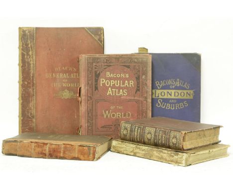
ATLASES:1. Black's General Atlas of the World. L, for A&C Black, 1882. Coloured maps, folio, half leather. Worn; one map loose;2. Bacon's Popular Atlas of The World. 1901, with coloured maps; 4to. original pictorial cloth. Worn;3. Bacon’s Large-scale Atlas of London and Suburbs. No date, c.1901, new enlarged and improved edition; folio, original cloth. Spine detached and few maps with tears at folds (without loss);4. Bartholomew: Royal Atlas of England and Wales. Newnes, nd, early 1900. Worn; AF;5. Another copy as above;6. Encyclopaedia Britannica Volume 34: Maps. 1903, 10th edn. 4to. Covers worn (6)

Lot 253
VELLUM BINDINGS:1. Evans, J Gwenogvryn: Facsimile and Text of the Book of Aneirin. Issued for subscribers only, 1908, limited edn. not numbered, but inscribed and signed by J G Evans, 1925; 4to. folding map, three-quarter vellum, gilt and teg. VG;2. Plato: Platonis Opera Omnia. C Tauchnitii, Lipsiae, 1881, pp725, (iii). Contemporary full vellum. Little grubby; o/w VG;3. Dindorf, William (editor): Poetarum. Scenicorum Graecorum. L, D Nutt, 1869; ppxiv, (i), 127, xiii, (i), 172, 376, 232. Contemporary full vellum, gilt; prize label. Occasional foxing; o/w VG;4. Evans, J Gwenogvryn: Poems from the Book of Taliesin. Llanbedrog, 1915, 1908, limited edn. not numbered, but inscribed and signed by J G Evans, 1925; half vellum, gilt and teg. Small stain to spine; o/w VG (4)

Lot 255
DE BASSOT, C P:Parga and the Ionian Islands: comprehending a refutation of the mis-statements of the quarterly review and of Lieutenant General Sir Thomas Maitland, on the trial between that officer and the author,Illustrated with maps. L, J warren, 1821, 1st edn. ppxxii, (ii), 1-130, 130a, b, c, d, & 131-530. With one folding map only?. Original plain paper boards, chipped; a few pages torn when roughly opened (without loss), most pages unopened; o/w VG. Very scarce, no copy at the British Library. One copy at Stamford University with one map also. Plus: three other travel books (4)

Lot 262
MAPS, ETC:1. Bacon's New Map of the River Thames, from its source to the sea; showing all the islands, bridges, railways and stations. Being a guide for yachtsmen, oarsmen, anglers and excursionists. 1869, coloured linen backed folding in original cloth covers; priced 2s 6d. G+/VG;2. Smith, W H: Plan of London, with index. Nd. Large coloured folding in original cloth covers; priced 2s;3. Henderson, Hamish: Elegies For the Dead in Cyrenaica. 1948, 1st edn. dw. Inscribed and signed copy;4. Griffith Davies & Mowat: Chronicle of Kingship. Inscribed and signed by Griffith Davies;5. Pevsner, Nikolaus. Signed letter in original envelope;6. Plus four of his Buildings of England Guides. Baedeker’s Guides, etc. (20)


![DUBLIN IN PRINT: COLBY (Colonel T F):Ordnance Survey of the County of Londonderry,Volume the First [all published]. Dublin:](https://cdn.globalauctionplatform.com/6aa914bf-f418-4c2b-acd7-a52500e8224f/aec4cb4c-3f7f-4ae7-88b8-547dfcd89ac5/468x382.jpg)
Lot 56
DUBLIN IN PRINT: COLBY (Colonel T F):Ordnance Survey of the County of Londonderry,Volume the First [all published]. Dublin: Published for Her Majestys Government; Hodges & Smith, 1837. First edn., 4to, hand-coloured geological map of the Parish of Templemore, folding plan of the City of Londonderry (foxed), 8 other plans, 1 view, 7 natural history plates (2 hand-coloured), plus illustrations in the text. Rebound in modern cloth; foxing (some heavy)


Lot 171
A quantity of prints to inc good quality 18th & 19th century engravings & etchings: Russian Women, hand coloured engraving got Banke's New System of Geography; Le palais du resident general a Hanoi & L'Ecole Cambodgienne a Paris; A view of the Hospital & Piazza of St Mary at Florence; Winecellar Entry Belfast; St Bartholemew's Smithfield by Henry Lambert; Early hand colour map of Great Britain etc (10)


Lot 346a
Rare Hardbacked Fully Signed Last Wembley Football Programme: Famous England v West Germany 2000 hardbacked programme which has a fully signed team sheet of the England Squad stuck inside first page including Keegan which was probably the last he signed as Manager. 28 autographs include Beckham Ferdinand Adams both Nevilles and Coles etc. C/W signature map. Vendor paid over £500 for this rare item.

Lot 367
Liverpool Fully Signed 2005 Football Programme: Match v West Ham dated 29 10 2005 fully signed in gold to cover by Hyypia Reina Gerrard Carragher Warnock Morientes Ciise Finnan Alonso Sissoko Carson Crouch Hamman Zender Garcia and Kewell plus signed card of McManaman. C/W signature map and UACC COA.

Lot 265
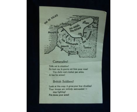
DUNKIRK EVACUATION NAZI PROPAGANDA DROP LEAFLET. A rare Nazi propaganda leaflet, these were dropped on the retreating allied troops by the Luftwaffe as they made for the beaches for evacuation urging the troops to surrender. English and French language with a map showing the German positions. 20-30

Lot 385
'A Map of Wiltshire', by C Dicey and Co., London, c1756, handcoloured, 40cm x 49cm. Having acquired the original plate from Henry Overton (fl. 1707-51) where the map had featured in the 'Overton Altas' in numerous editions from c1680 - c1738, C Dicey and Co altered the title from 'Wiltonia sive comitatus Wiltoniensis, Anglis Wilshire' to 'A Map of Wiltshire' before including it in their own Atlas. The original plate by John Overton (1640-1713), c1680, was in turn copied from a map by Jan Jansson (1588-1664) c1646 CONDITION REPORT: Condition good
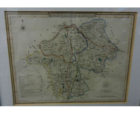
Lot 387
'Westmorland', by G Cole and engraved by J Roper, issued alongside other county maps between 1804-1810, hand coloured, 18cm x 23.5cm 'Berkshire' by R Creighton and engraved by T Starling, published in the 'Atlas to the Topographical Dictionaries of England and Wales' by S Lewis and Co., c1849., 19cm x 24cm, and two reproduction maps; 'Saxton's Map of England and Wales, 1579' and 'Saxton's map of Westmorland and Cumberland, 1576', all framed and glazed
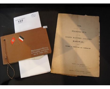
Lot 117
A commemorative Third Reich photograph album, commemorating the opening of the newly elected Reichstag at Potsdam, 21st March 1933, together with an 1834 prospectus of the Grand Eastern Counties Railway from London to Norwich and Yarmouth. Condition Report: Includes map as shown in images. NB: Item is in fragile and torn condition.


-
109182 item(s)/page