We found 109198 price guide item(s) matching your search
There are 109198 lots that match your search criteria. Subscribe now to get instant access to the full price guide service.
Click here to subscribe- List
- Grid
-
109198 item(s)/page


Lot 235
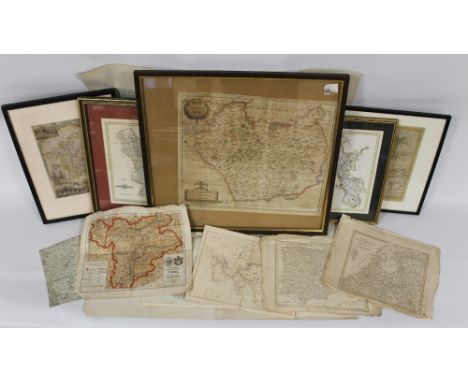
A QUANTITY OF 18TH & 19TH CENTURY MAPS to include framed and glazed Robert Morden of Leicestershire, Thomas Kitchin of Derbyshire, John Cary of Derbyshire, Thomas Moule of Worcestershire together with loose maps of Europe, various maps published by James Virtue and a 1932 Ordnance Survey War Revision 1940 one inch map of the Isle of Man

Lot 236
TWO 18TH CENTURY MAPS OF NORTH AMERICA - G. Rollos - 'An Accurate Map of Louisiana, and the Territory in Dispute between the English and the French' engraved for 'The British Magazine' and J. Gibson - 'An Accurate Map of the British Empire in Nth. America as settled by the Preliminaries in 1762' engraved for the Gentleman's Magazine (2)


Lot 240
A JOHN SPEED MAP OF WORCESTERSHIRE c.1627 or earlier (Sudbury and Humble), English text on back together with two double framed Owen & Bowen pages showing the Arms of the Colleges of Oxford and Cambridge with road maps on reverse c. 1736 and a framed J & C Walker town plan of Ludlow c. 1834 (3)


Lot 326
A collection of various, mainly GWR, Railwayana, including one volume "Great Western Railway Company Running Powers" published Kelly & Kelly Limited London May 1927, tooled and gilded leather bound no'd 95, together with various letters and notes relating to same and E T MacDermott "History of The Great Western Railway" Volume I, part I, II and III and Volume II published GWR Paddington Station London 1927, tooled and gilded clothboard bound, one Volume GA Sekon "A History of The Great Western Railway" being the story of "The Broad Gauge" published Digby Long & Co 1895, tooled and gilded clothboard bound, together with various other books, instruction manuals, maps, station accounts instruction book, together with official railway maps including railway clearing house official railway map of south wales and official railway map of the west of England, tooled and gilded clothboard bound, one volume History of the Barry Railway Company 1884-1921 published Tudor Printing Works Western Mail Ltd 1923, two clothboard and leather bound volumes of newspaper cuttings etc relating to R H Nicholls 1884-1932 (R H Nicholls and R H B Nicholls father and son) containing articles published circa 23.12.1932 - January 1933 (Nicholls was Superintendent of the GWR line) together with various other Railwayana prints, an aluminium plaque depicting Brunel etc plus two Vale and Bradnack wooden handled clothes brushes with GWR emblem


Lot 69
Stevenson (Robert Louis). Kidnapped being Memoirs of the Adventures of David Balfour in the year 1751, 1st edition, 1st issue, Cassell & Company, 1886, half-title, without the folding map, first issue text, with 'business' for 'pleasure' on page 40, line 11, single page advertisement to verso of final leaf at rear for the illustrated edition of Treasure Island, and 16 pages publisher's list (first issue state, with 5 G. 4.86 at foot), some light spotting to preliminary leaves, original brown cloth gilt, rubbed and some marks, 8vo, together with The Merry Men and Other Tales and Fables, 1st edition, 1887, original decorated blue cloth gilt, rubbed and some marks, with slight fraying to extremities, plus The Master of Ballantrae. A Winter's Tale, 1st edition, 1889, 4 pages of adverts, and 16-page publisher's catalogue at rear (dated 5 G. 7.89), original pictorial red cloth gilt, slightly rubbed, with another copy of the same work, also a first edition of 1889, rebound in modern blue half morocco by Sotheran, and Stevenson (Robert Louis, and Lloyd, Osbourne), The Wrong Box, 1st edition, 1889, The Wrecker, 1st edition, 1892 & The Ebb Tide, 1st edition, 1894, adverts to each volume at rear, original red, blue and gold cloth respectively, rubbed, all 8vo, plus 8 other R.L. Stevenson volumes, mostly first editions, all 8vo (15)

Lot 111
Adams (Richard). The Plague Dogs, 1st edition, Allen Lane, 1977, illustrations and diagrams to text by Alan Wainwright, some full-page, bookplate of Richard Adams, all edges gilt, together with Shardik, Allen Lane, reprinted 1975, map endpapers, front hinge splitting, bookplate of Richard Adams on verso of front free endpaper, the two volumes uniformly bound in contemporary olive green morocco, each with gilt lettered spine label, both rubbed in places, Plague Dogs with some damp-mottling to covers, 8vo The author's specially bound copies. (2)
![Hardy (Thomas). Jude the Obscure, 1st edition in bookform, Osgood, McIlvaine and Co., 1896 [1895], half-title present, etched](https://cdn.globalauctionplatform.com/4af01a9b-4bad-4f0c-be78-a82e00ec44c3/63bddfab-027e-43b3-c7b2-76d983d4501d/468x382.jpg)
Lot 57
Hardy (Thomas). Jude the Obscure, 1st edition in bookform, Osgood, McIlvaine and Co., 1896 [1895], half-title present, etched frontispiece by H. Macbeth-Raeburn, with tissue guard, single-page map, marbled endpapers, bookplate of Richard Adams, all edges gilt, modern green calf by Bayntun (Riviere), signed on front turn-in and with ink stamp on verso of front free endpaper, some faint mottling on covers, gilt triple roundel decorated raised bands, remainder gilt panelled with single fillet, gilt lettered direct in second and third compartments, date lettered at foot, covers with gilt single fillet border, bead roll on edges, turn-ins with double fillets and palmette cornerpieces, 8vo Purdy, pages 86-91. Sadleir 1108. (1)


Lot 1203
ACE Trains 0 Gauge 4-6-0 ‘Castle Class’ Locomotive and Tender, E/7 in Great Western livery with single chimney, two or three rail, fire box glow in cab with unattached name plates 5050 ‘Earl of St Germans’ and alternative head boards, in original box with outer box and Great Western Railway map, E, box G-E


Lot 452
Books/Maps - Edward Stanford - 19th Century engraved folding map - Guiana & Venezuela, James Wyld - 19th Century engraved folding map - Dominion of Canada (Central and Eastern sheets connected as one), The Lakes Of Killarney, published by T.Nelson & Sons, 1859, one slim volume with eight lithographic illustrations and folding map and The Arminian Magazine 1793 and 1794 (volumes 16 and 17), two full leather bound volumes Condition:

Lot 44
A World War I medal group of three 1363, Pte S Hodgeon 5th East Lancashire including 1914 - 15 star. An 1889 Victoria India Army Temperance Association six month medal, a pocket compass / distance measure, two photographs and a copy map showing German Advance and British Retreat March 21st to March 28th 1918 (8)


Lot 583
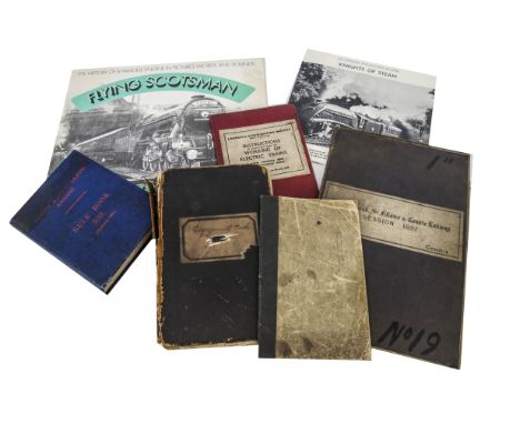
Victorian Scottish Railway Map, engagement book and Pricing book, 1897 folding map on linen of the Locherhead, St Fillans and Comrie railway (showing estate owners) together with 1882-1900 staff engagement book believed to be St Rollox Works, and 1873 rolling stock costing book, LNER 1933 Rule book, 1938 Electric train instruction manual and two vinyl recordings including Flying Scotsman P-G (7)


-
109198 item(s)/page