We found 109198 price guide item(s) matching your search
There are 109198 lots that match your search criteria. Subscribe now to get instant access to the full price guide service.
Click here to subscribe- List
- Grid
-
109198 item(s)/page


Lot 128
Jacques Nicholas Bellin, 'Carte des Variations de la Boussole et des Vents Generaux que l'on Trouve dans les Mers les plus Frequentees', published. Paris, 1765, world map on a Mercator projection, ordered by Mr. De Choiseul (Minister of War and the Marine), within a glazed frame, 56 cm x 86 cm
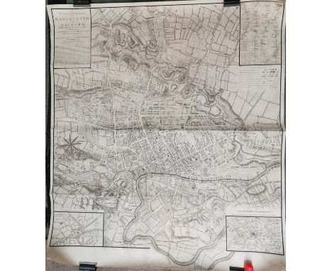
Lot 138
A Topographical Plan of Manchester and Salford, with the adjacent parts, shewing also the Different Allotments of Land proposed to be built on, As communicated to the Surveyor by the respective Proprietors (...), published December 9th 1793, by C. Laurent, the map lined on fabric, 108 cm x 95.5 cm

Lot 6
Phillips (Chas.) Specimens of Irish Eloquence, L. 1819. First Edn., engd. ports. hf. mor.; Gilpin (Wm.) An Essay on Prints, L. 1792. Fourth, cont. tree calf; Paterson - A New and Accurate Description of all the Roads in England & Wales, L. 1811, lg. fold. map frontis & 7 other double page maps, hf. calf, worn; also Universal Gazetteer, sm. 8vo D. n.d. c. 1770, 3 fold. hd. cold. maps by Kitchin etc., cont. calf. As a lot, w.a.f. (4)
![Co. Derry: Colby (Col. Thos.) Ordnance Survey of the County of Londonderry, Part I [All Published] D. 1837, First E](https://cdn.globalauctionplatform.com/f4e1af99-2601-4c42-957a-acca00e9a9d6/4bee573e-5d56-4b93-bc14-accd00adf51d/468x382.jpg)
Lot 108
Co. Derry: Colby (Col. Thos.) Ordnance Survey of the County of Londonderry, Part I [All Published] D. 1837, First Edn., hd. cold. map & other fold. maps etc., also hd. cold. & other plts., text illus. etc. orig. cloth, v. good; [Phillips (Sir Thos.)] Londonderry and the London Companies 1609 - 1629, sm. folio Belfast (H.M.S.O.) 1928. First Edn., cold. & other maps, orig. cloth. V. good. (2)

![[Twiss (Richard)] A Tour in Ireland in 1775, 8vo, L. 1776, First, fold map frontis & plt., with m/ss notes](https://cdn.globalauctionplatform.com/f4e1af99-2601-4c42-957a-acca00e9a9d6/216c558f-98d4-4606-83c6-accd00ae0669/468x382.jpg)

Lot 132
Donn (James) Hortus Cantabrigiensis, or, A Catalogue of Plants Indigenous and Exotic. Sm. 8vo Cambridge 1811. Sixth, hf. calf; Faulkner (Thos.) The Historical and Topographical Description of Chelsea and its Environs, 2 vols. Chelsea 1829, eng.d plts. some hd. cold., fold. map & wd. cut illus., hf. calf, spines dam.; Wraxall (Wm.) Memoirs of the Courts of Berlin... and Vienna, 2 vols. L. 1806, hf. calf. (5)


Lot 17
Maps: England & Wales: Faden (W.) A Map of England, Wales & Scotland, describing all the Direct and Principal Cross Roads in Great Britain… L. 1801, lg. fold. linen backed map, 76cms x 62cms (30" x 24 1/2"), fully hd. cold., slip case; Stanford (Ed.) Railway Map of the British Isles and Part of France, by B.R. Davies. L. c. 1880. Lg. folding map on linen, bright hand colouring, 97cms x 81cms (38" x 32") approx. in slip case; Stanford's Portable Map of England and Wales with The Railways… L. c. 1881, fold. linen backed map, fully hand cold, 83cms x 76cms (32 1/2" x 30"), fold. cloth covers. As maps, w.a.f. (3)


Lot 374
Map: Co. Mayo: Joynt & Son, Ballina Map of Lough Conn and Lough Cullin, Situate in the Parishes of Kilbelfad, Ballynahaglish, Templemore, Turlough, Addergoole & Crossmolina, Baronies of Tirawley, Gallen & Carra and County of Mayo, Lg. hd. coloured engd. map, approx. 59cms x 67cms (26 1/2" x 23") dated 1866, gilt frame. V. good & Rare. (1)


![Denton's Railway Guide, no date [c.1862], a booklet featuring folding map of the Midland Railway and timetable/fares, bound i](https://cdn.globalauctionplatform.com/dd22acfb-4cb7-4ea0-8c24-acd000ea6c2a/363cf238-5f0b-41b1-953f-acd500c89f2c/468x382.jpg)
Lot 290A
Denton's Railway Guide, no date [c.1862], a booklet featuring folding map of the Midland Railway and timetable/fares, bound in publisher's coloured paper covers bearing advertisements. Together with a vintage MGB Driver's Handbook; maintenance book for Stone's turbo-generator Type TGI; small quantity of 1970s British Railways repair labels; collection of mid-20th century railway postcards


Lot 68
John Speed County Palatine map of Cheshire, measurements 39.5 x 50.5 cm (PL), frame 45.5 x 58 cm, together with a further map of Cheshire, measurements 38 x 50 cm (PL), frame 44 x 56 cm (2)Condition report: Speed: centre fold-potential repaired tear with some minor wear and small losses. Uniform discolouration but slightly darker in the upper left and right margins. Colours generally good. two small tears to the top-centre-left and left top corner in the margins- not extending into the plate. A small tear in the centre right margin. Some sparse black spots of foxing Second: minor crease to centre fold. A few minor foxing spots. Light fading but very little discolouration. Colours fairly good throughout.


Lot 148
Large colour map of Europe from Prayer Room at Liverpool Football Club's Melwood Training Ground,with legend shown in six languages, mounted on board with metal surround, wipe-clean plastic finish, 110 by 93 by 2cm. wall-mounting holes from previous hanging, good; sold with a certificate of authenticity issued by Liverpool Football Club
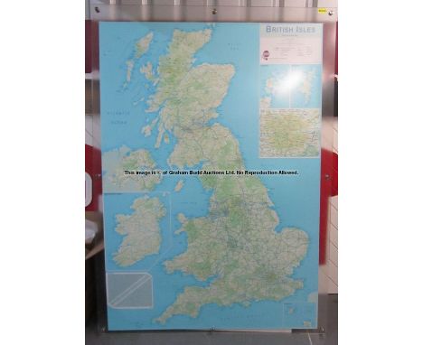
Lot 98
Large route planner colour wall map of the British Isles from Jurgen Klopp's Manager's Office at Liverpool Football Club's Melwood Training Ground, said to be the first item Jurgen Klopp requested on arrival at Liverpool, encased between two perspex sheets with original metal wall mountings, 168 by 114.5 by 1.5cm., good; sold with a certificate of authenticity issued by Liverpool Football Club


Lot 277
After Bernard Picart (1673-1733)12 framed engravingsFrom "Religious Ceremonies of the World", each approx 16cm x 9.5cm, framed as oneAfter Bernard PicartPair of engravingsSultan and his wife, 33cm x 22cm After David Burr Map of the County of Seneca, 38cm x 31cm Map of the Counties of Ontario and Yates, both dated 1829 (5)

Lot 312
After Robert Morden, colour map of Glostershire AD1712, labelled to reverse 'Regent Gallery, 14 Regent Street, Cheltenham, Antique Maps and Prints' and 'Sir Robert Atkyns Map of Glostershire 1712, the edition of 1764 although this map is remarkably like Robert Morden's map of 1695 there is no information as to its authorship or its engraver', 33cm x 39cm, framed


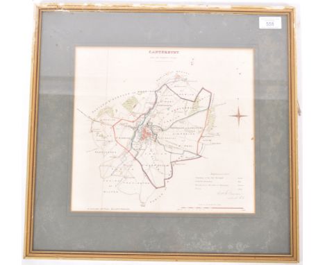
Lot 558
An early to mid 20th Century English lithograph hand coloured Ordnance Survey map for Canterbury and its borders. The map with hand coloured boundaries and further highlighted areas with a small summary to the bottom right. Printed by R. Cartwright Litho Printer and singed by Lieutenant Robert K. Dawson of the Royal Engineers. Framed and glazed. Measures approx 44cm x 46cm.


Lot 410
THREE BOXES OF CERAMICS, GLASS, DVD'S, BOOKS, CD'S, METALWARES, FOLDING MAGAZINE RACK, etc, including cafetieres, animal ornaments, Laura Ashley jewellery box, Lladro and Boodles catalogues, signed Paul Burrell 'Entertaining with style' book, trivets, candles, cushion, Royal commemorative mugs, short history of Sutton Coldfield with facsimile map, etc (three boxes)
-
109198 item(s)/page