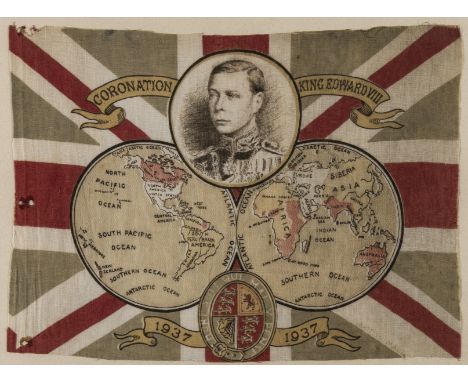
We found 109198 price guide item(s) matching your search

Refine your search

Year

Filter by Price Range
  • List
  • Grid
  • 109198 item(s)
    /page

Lot 106

World.- Anonymous. Coronation King Edward VIII souvenir flag map, with a portrait of the King and a double-hemisphere world map with the British Empire coloured red, and the Royal Arms illustrated over a Union Jack background, colour-printed wood engraving on linen, 230 x 320 mm (9 x 12 1/2 in), small holes and rough edges, minor surface dirt, framed, [1936].⁂ The flag was printed in 1936 ready for the Coronation which was to take place the following year. However, Edward VIII chose love and marriage to Mrs Wallis Simpson rather than the throne and crown. Edward abdicated on 11th December 1936 and George VI was crowned instead.

Lot 108

NO RESERVE Britain.- Camden (William) Britannia siue Florentissimorum regnorum, Angliae, Scotiae, Hiberniae, et insularum adiacentium ex intima antiquitate chorographica descriptio...., engraved title by William Rogers, letterpress title with woodcut Royal arms bound after dedication, one folding engraved map only (Britannia Provincia Romanorum) by William Rogers, ten full-page engraved illustrations including map of Ireland and view of Stonehenge, several woodcut illustrations and decorative initials, small loss to lower right corner of engraved title, the folding map with some nicks and minor losses to extremities, occasional spotting and browning, modern calf reback with red label, gilt, boards very worn, 4to, George Bishop, 1600.Provenance:G. Harold Culshaw (bookplate to front pastedown)

Lot 110

Britain.- Hermannides (Rutgerus) Britannia magna, sive Angliae, Scotiae, Hiberniae et adjacentium insularum geographico-historica descriptio, engraved pictorial title, with 32 engraved folding plans, including the general folding map and map of London, the maps of Hull, Exeter and Oxford probably from another copy and tipped in, otherwise scattered nicks and tears, old folds, some spotting and browning, bookplate of Charles Edward Fewster, Hull, contemporary vellum, spine with ink title inscribed, yapp edges, soiled, 12mo, Amsterdam, Gillis Jansz Valckenier, 1661.Literature:cf. Howgego 13

Lot 111

NO RESERVE Britain.- Hermannides (Rutgerus) Britannia magna, sive Angliae, Scotiae, Hiberniae et adjacentium insularum geographico-historica descriptio, engraved pictorial title, with 31 engraved folding plans only, lacking the general folding map, but the map of London present, the first 170 pp. heavily cleaned, the pages thereafter with minor damp-staining and some browning throughout, rebacked, vellum restored at edges, worn, 12mo, Amsterdam, Gillis Jansz Valckenier, 1661.Literature:cf. Howgego 13

Lot 114

NO RESERVE Britain.- Senex (John) The Roads through England delineated or, Ogilby's Survey, Revised, Improved and Reduced to a size portable for the Pocket..., engraved title, engraved map of England & Wales and 101 uncoloured strip road maps printed back-to-back, title page frayed and torn with slight loss, water stained throughout with some discolouration to first part, final two leaves with closed tears crudely repaired with tape, new end papers, modern limp calf gilt, oblong 8vo, 1759.

Lot 115

NO RESERVE Britain.- Cary (John) Cary's Traveller's Companion, or a Delineation of the Turnpike Roads of England and Wales..., calligraphic title, advertisement and contents, general map of England & Wales and forty-one engraved maps only with contemporary outline colouring, lacking folding map of Yorkshire, maps printed back-to-back, minor off-setting, some spotting and surface dirt, contemporary tree calf, upper cover detached, rubbed and scuffed, 8vo, 1st Jan., 1790.

Lot 116

Britain.- Paterson (Daniel) Paterson's British Itinerary. Being a New and Accurate Delineation and Description of the Direct and Principal Cross Roads of Great Britain, 2 vol. in 1, frontispiece of a double-page engraved map of England & Wales with contemporary hand-colouring, calligraphic title, dedication, contents list and preface, index, 360 engraved strip road maps, printed in pairs and back to back, list of cross roads, errata and publisher's advertisement at rear, occasional browning and spotting, contemporary tree calf, gilt, red morocco label to spine, spine splitting, hinges cracked with loss to ends, other wear to extremities, 8vo, Carrington Bowles, 1785.

Lot 117

Britain.- Cary (John) Cary's New Map of England and Wales with Part of Scotland, engraved title, hand-coloured general map and 76 sheets (numbered 1-81), mostly engraved maps hand-coloured in outline but including dedication, key and scale as part of sheets, no sheets numbered 62, 71 or 80, [?] as issued, bound with index and list of places, occasional spotting and browning, minor off-setting, modern half calf, 4to, 1794.

Lot 118

NO RESERVE Britain.- Paterson (Daniel) Paterson's Roads, 18th edition, folding engraved general map frontispiece and 8 folding maps, the maps mounted on linen, the general map with some splitting and and repairs to minor loss, spotting and browning, the title on paper support, otherwise occasional light toning, rebacked modern half calf, original boards rubbed and worn, 8vo, Edward Mogg, Longman, Rees, Orme, et al., 1826; together with two copies of vol. 1 only of Paterson's 1785 British Itinerary, both with double-page general map and 188 strip road maps, and vol. 1 only of Carrington Bowles's Bowles's Post-Chaise Companion; or a Travellers Directory through England and Wales..., with 98 road strip maps, boards loose, worn 8vo, 1782-1785 (4)

Lot 12

NO RESERVE Map Curiosity.- Basire (James) A Map of Time, three circular engraved diagrams invented by F. King, with 4 pp. letterpress booklet of accompanying descriptive text, largest images each approx. 370 x 360 mm (14 1/2 x 14 1/8 in), handling creases and folds within margins, several nicks and tears, some into plates, surface dirt and browning, unframed, 1785 (3)

Lot 121

England & Wales.- Speed (John) The Kingdome of England, First edition, 'carte-a-figure' map with eight costumed figures to vertical margins, the seas decorated with ships and monsters, engraving with hand-colouring, sheet 395 x 530 mm (15 1/2 x 20 7/8 in), trimmed with border at left and right, margins restored with further associated loss restored in manuscript facsimile, central vertical fold reinforced verso with careful repairs to splitting and minor loss, unframed, John Sudbury & George Humble, [circa 1611]

Lot 127

Cornwall.- Saxton (Christopher) & Philip Lea. Cornwall... Corrected & Many Additions in the Roads, county map with inset view of Launceston surmounted by Royal coat-of-arms, and decorated with ships, sea-monsters and ducal arms, engraving with hand-colouring, 370 x 490 mm (14 1/2 x 19 1/4 in), under glass, laid on support with repairs to old splits and small loss, some areas restored in manuscript facsimile, spotting and browning, some damp-stains to lower edges, framed, [circa 1694].

Lot 128

Durham.- Speed (John) The Bishoprick and Citie of Durham, First edition, county map with inset town plan of Durham, engraving with some hand-colouring, sheet 420 x 510 mm (16 1/2 x 20 in), English text verso with first edition woodcut initial, central vertical fold with careful repair verso to minor splitting at foot, some even toning and light spotting, with minor surface dirt, unframed, [1611].

Lot 129

Hampshire.- Saxton (Christopher) & Philip Lea. Hampshire, county map with inset map of Winchester in the upper left corner, engraving with hand-colouring, platemark 400 x 430 mm (15 3/4 x 17 in), central vertical fold with careful repairs to old splitting, restoration to edges with some marginal loss and repaired tears, unframed, [circa 1695].

Lot 131

London.- Overton (Henry) A New & Correct Map of Thirty Miles Round London Shewing all the Towns, Villages Roads &c..., scarce circular map of the enirons of London, showing from Great Marlow in the West, clockwise to Baldock, Chelmsford, Canvey Island, Maidstone, Horsham and Godalming, with extensive key of place names to left and right edges, engraving with outline hand-colouring, on laid paper without watermark, 620 x 970 mm (24 1/4 x 38 1/4 in), central vertical fold with some splitting, other folds and handling creases with restoration to sheet loss and splits visible verso, numerous small tears at edges, notable loss just to the right edge of the title, trimmed with rough edges, minor surface dirt, unframed, [circa 1720]Literature:Howgego 67 (1)

Lot 132

NO RESERVE London.- Anonymous. An Accurate Map of the Country Sixteen Miles round London Drawn and Engrav'd from an Actual Survey, originally published in four parts with The Gentleman's Magazine, engravings, four sheets conjoined, total sheet approx. 430 x 410 mm (17 x 16 1/8 in), mounted on paper support, careful repairs to old splitting, nicks and small losses, unframed, [circa 1764]; together with John Harrison's A Map of Middlesex, engraving, 360 x 470 mm (14 1/8 x 18 1/2 in), unframed, 1787 (2)

Lot 136

NO RESERVE London.- Ambulator: or, a pocket companion in a tour round London, within the circuit of twenty five miles: describing whatever is most remarkable for antiquity, grandeur, elegance, or rural beauty: Including New Catalogues of Pictures, printed on bluish paper, folding hand-coloured engraved frontispiece map, some damp-staining and cockling to map, small tear, otherwise scattered spotting and browning throughout, owner's ink inscription to front free endpaper 'Richard Alsop', with book plate to paste down 'Montagu Egerton Loftus', tree calf, gilt, rubbed and slightly worn, printed for J. Scatcherd, Ave Maria Lane, 1796

Lot 143

London.- Collins (Henry George) Collins' London, showing from Kensall Green to Highbury, and the Isle of Dogs to Brixton, lithograph, 560 x 750 mm (22 x 29 1/2 in), folds with a few splits and minor wear, bound with 17 pp. index pasted into inside upper cover, the map folding into original boards with orange publisher's label to upper cover, rubbed and scuffed, 8vo, 1855.⁂ Scarce example of a shilling pocket map of London.

Lot 144

London.- Reynolds (James) A New Map of London and the adjacent Villages, with the New Streets & Public Buildings, showing from Hyde Park to Islington, and Stratford to Elephant and Castle, with alphabetical reference key to streets underneath, engraving with some hand-colouring, 425 x 795 mm (16 3/4 x 31 1/4 in), dissected into three horizontal strips and mounted on linen, some spotting and browning, with surface dirt and minor nicks to splits and folds, folding into original covers with 'Booth's Guide to the Sights of London and Strangers Companion', original publisher's printed label to upper cover, spine split, very worn, 8vo, 1845Literature:Howgego 393

Lot 145

London.- Whitbread (Josiah) Whitbread's New Plan of London Drawn From Authentic Sources, covering Holland Park to Kentish Town, and Shadwell to Denmark Hill, engraving with contemporary hand-colouring, 465 x 645 mm (18 1/4 x 25 1/2 in), mounted on linen, folding into original blue cloth-covered boards alongside 'Index to Whitbread's New Distance Map of London, embossed and with gilt title to upper cover, collector's bookplate of Frederick Phinney to inside upper cover, rubbed, 16mo, [1857].

Lot 146

London.- Cruchley (George Frederick) From the Ordnance Survey of the Country Thirty Miles round London, map of the environs of London showing from Hertford to Godalming and Tunbridge, and from Maidenhead to Chatham, engraving with bold original hand-colouring, 1115 x 1380 mm (43 3/4 x 54 1/4 in), dissected and mounted on linen, folding without slipcase, 4to, [c.f. Howgego 333 for possible source], n.d., [circa 1850 or slightly later].

Lot 147

London.- Davies (Benjamin Rees) Davies's Map of the Environs of London, showing from Potters Bar to Dartford, and Leatherhead to Slough, engraved map with contemporary hand-colouring, 750 x 1070 mm (29 1/2 x 42 in), dissected and mounted on linen, some minor surface dirt and browning, folding with marbled endpaper into original blue cloth embossed slipcase, gilt, lacking spine, worn, 8vo, [cf. Howgego 372], 1856; together with an anonymous folding 20th century plan of London, and Bradshaw's Railway Companion, containing the times of departure..., with folding map of London, 16mo, 1844 (3)

Lot 148

NO RESERVE London.- Davies (Benjamin Rees) Davies's Map of the Environs of London, large folding map centred on Westminster, showing from Waltham Abbey to Dartford, and Epsom to Windsor, engraving, 760 x 1080 mm (30 x 42 1/2 in), scattered spotting and surface dirt, folding with green endpaper, remnants of old lower cover, lacking spine and upper cover, worn, 8vo, 1858.

Lot 150

London.- Smith & Sons (Charles) Illustrated Map of London, map of London from Hyde Park to Islington, and Whitechapel to Vauxhall, with numerous bird's-eye view vignette illustrations showing sites of interest, lithograph with some hand-colouring, sheet 500 x 670 mm (19 3/4 x 26 1/4 in), dissected and mounted on linen, repaired splitting to folds throughout, cockling and surface dirt, unframed, [circa 1880].

Lot 151

London.- Stanford (Edward) Nine detailed map sheets of London, including individual sheets of Hackney, Westminster, Tower Hamlets, Finsbury, Southwark, Greenwich East, Greenwich West, Lambeth East, and Lambeth West, lithographs, various sizes, between 345 x 550 mm (13 1/2 x 21 3/4 in) to 1080 x 1270 mm (42 1/2 x 50 in), dissected and mounted on linen, occasional splitting to folds, some with ink staining, browning and surface dirt, all folding with marbled endpapers, slightly worn, 4to, [late 19th century] (9)

Lot 152

London.- Dower (John) The River Thames from its Source to the Sea, map of the Thames valley comprising three strip maps, lithograph with hand-colouring, sheet 510 x 660 mm (20 x 26 in), central vertical fold, minor handling creases, unframed, published by Cassell, Petter & Galpin, [late 19th century]; together with James Bartholomew's Plan of London, Metropolitan Burghs and Southern & Eastern Environs, lithograph with full hand-colouring, 270 x 360 mm (10 5/8 x 14 1/8 in), minro handling creases, unframed, [late 19th century] (2)

Lot 153

NO RESERVE London.- Kelly & Co. (publisher) London Drawn & Engraved Expressly for the Post Office Directory 1901, large folding lithographed map, 760 x 1080 mm (29 7/8 x 42 1/2 in), dissected and mounted on linen, some splitting, handling creases, surface dirt, spotting and browning, unframed, 1901

Lot 154

London.- Booth (Charles) Descriptive Map of East End Poverty, Compiled from School Board Reports' in 1887, folding plan of East London, including Whitechapel, Bethnal Green, Shoreditch, Stepney, Mile End, and part of Poplar, with coloured key identifying 'general condition of inhabitants' from 'Very poor, lowest class... Vicious, semi-criminal' to 'Well-to-do', lithograph printed in colours, 372 x 485 mm (14 3/4 x 19 in), dissected and mounted on linen, folding into original volume, 'Labour and Life of the People. Volume 1: East London', second edition, original boards, rubbed, 4to, Williams and Norgate, 1889.

Lot 155

Boston-printed guide to London & Paris.- Bartlett (George Warren) Bartlett's Illustrated Map of London & Paris, two folding 'Stranger's Guide[s] to the Public Buildings, Theatres, Music Halls & Places of Interest' of London and Paris, both decorated with vignettes throughout, lithographs, London sheet 500 x 600 mm (19 3/4 x 23 1/2 in), Paris sheet 425 x 580 mm (16 3/4 x 22 3/4 in), some surface dirt and toning, folding with original covers, but disbound lacking spine, upper cover with title in gilt, 7 pp. pamphlet pasted to inside of detached upper cover, worn, 8vo, Boston, Massachusetts: G. Warren Bartlett, 149a Tremont St., 1877.

Lot 157

Northumberland.- Speed (John) Northumberland, county map with inset town plans of Berwick and Newcastle, engraving with hand-colouring, sheet 415 x 540 mm (16 1/4 x 21 1/4 in), central vertical fold with repairs verso to splitting, damp-stain and expert repair to platemark perforation in lower right corner, otherwise minor cockling and handling creases, unframed, Sudbury and Humble, [1611, but slightly later].

Lot 17

Atlases.- Thomson (John) [A new general atlas, consisting of a series of geographical designs, on various projections, exhibiting the form and component parts of the globe; and a collection of maps and charts], 73 folio sheets only, including a map of Europe across 4 sheets, 2 variant maps of the Arabian peninsula, and others of America, Islands of the Pacific Ocean, Asia, the East India Islands, several of India, and six sheets of the hemispheres, engravings with hand-colouring in outline, on wove papers with watermark dates from 1795 to 1812, each sheet approx. 540 x 720 mm (21 1/4 x 28 1/4 in), map of Barbados trimmed to half-sheet measuring 515 x 320 mm (20 1/4 x 12 1/2 in), first map loose, first dozen with nicks and losses to extremities, handing creases, large tear to map of France with marginal loss, other smaller tears, occasional handling creases, rough edges, surface dirt and minor browning throughout, lacking spine, upper cover detached but present, very worn, oblong elephant folio, [Baldwin, Craddock & Joy], [1817].

Lot 18

NO RESERVE Atlases.- Lavoisne (C.V.) Lavoisne's Complete Genealogical, Historical, Chronological, and Geographical Atlas, including 67 hand-coloured double-page engravings only, title and 10 pp. introduction present but detached, the map sheets incorporating 42 genealogical tables and 25 engraved maps by Walker after J.Aspin, each sheet approx. 430 x 530 mm (16 7/8 x 20 7/8 in), sheets disbound and laid on 34 card sheets, mounted recto and verso, some old tears and repairs, surface dirt and browning throughout, covers present but detached, lacking spine, very worn, oblong folio, J.Barfield, 1817.

Lot 19

Atlases.- World.- Teesdale (Henry) A New General Atlas of the World, engraved vignette title, and 46 engraved maps only, all with outline hand-colouring, all double-page, some occasional nicks and tears to edges, map of England and Wales with lower half laid on support with repairs to tears and loss, India folding with 2 sheets conjoined, repaired tear in lower margin, otherwise occasional surface dirt and some browning throughout, modern half calf, spine gilt with red morocco label, folio, 1836.

Lot 2

World.- Buffier (Claude) Geographie Universelle, Exposee dans les Diferentes Metodes qui Peuvent Abreger l'Etude & Faciliter l'Usage de Cette Sience..., seventh edition, 18 folding engraved maps of the world, including a double-hemisphere world map, Britain, Asia, and America, title with owner's ink inscription scrubbed out with brown wash, the hemisphere map with ink annotations, otherwise a few minor handling creases and splits to olds folds, occasional minor spotting and browning, mottled calf, spine gilt, hinges cracked and splitting, corners bumped and with old repairs, worn, 8vo, 1749.

Lot 20

Atlases.- Johnston (Alexander Keith) The Royal Atlas of Modern Geography, 48 double-page maps hand-coloured in outline, with watercourses printed in blue and some inset city plans, mounted on stubs, interleaved with indices for each map, advertisements tipped in at rear, some splitting to central folds, occasional even toning and browning, contemporary half russia, gilt, g.e., rubbed and worn, folio, William Blackwood & Sons, Edinburgh and London, 1868.

Lot 21

Atlases.- Bevan (G. Philip) Royal Relief Atlas, of All Parts of the World, Third edition, 31 relief maps printed in colours, each leaf approx. 295 x 250 mm (11 3/4 x 9 7/8 in), mounted on stubs, the map of Africa with some loss to upper corner, New Zealand pasted onto inside lower cover, contents page with tears repaired with tape, other spotting and browning throughout, marginal nicks and tears, later covers, extremities rubbed, spine scuffed, George Phillip and Son, 1885.

Lot 24

Africa.- Jansson (Jan) Aethiopia Superior vel Interior; Vulgo Abissinorum sive Presbiteri Ioannis Imperium, map showing the legendary Christian Kingdom of Prester John, with numerous exotic animals decorating the largely unexplored interior, decorative title cartouche with native family holding parasols up to the sun in the lower right corner, engraving with hand-colouring on laid paper without watermark, platemark 385 x 500 mm. (15 1/8 x 19 3/4 in), good margins, Latin text verso, central vertical fold with careful repairs, scattered spotting and surface dirt, unframed, [circa 1645].

Lot 25

Africa.- Jansson (Jan) Guinea, map illustrating the coast from Sierra Leone to Gabon, the land filed with lions, elephants, and other other animals, the sea decorated with ships, sea monsters and compass roses, with large title cartouche featuring a native couple and four apes in the lower centre, and two further child-like sea creatures carrying a large elephant tusk in the lower left corner, engraving with early hand-colouring, platemark 385 x 520 mm (15 1/8 x 20 1/2 in), full margins, central vertical fold with expert repairs to splitting, other marginal repairs, some spotting and surface dirt, unframed, [circa 1650].

Lot 26

Africa.- Jansson (Jan) Nova Barbariae Descriptio, map of the whole of North Africa, showing from Morocco to the Nile delta, decorated with a pair of fanciful dragons, elephants, ostriches, antelopes and monkeys, engraving with early hand-colouring, platemark 355 x 515 mm (14 x 20 1/4 in), good margins, Latin text verso, central vertical fold with careful repairs, marginal creases, minor surface dirt, unframed, [circa 1650 or slightly later].

Lot 27

Africa.- Morocco.- Jansson (Jan) Fezzae et Marocchi Regna Africae, map of Morocco, including the Straits of Gibraltar, with north oriented to the right, engraving with hand-colouring, platemark 385 x 500 mm (15 1/8 x 19 3/4 in), full margins, Latin text verso, central vertical fold with careful repairs, some spotting and browning, unframed, [circa 1650].

Lot 28

Africa.- Morocco.- Keulen (Gerard van) & Pierre Mortier. Carte Particuliere Des Costes De L'Afrique Qui comprend une Partie De Congo, map of the Congo on the West Coast of Africa, from Cabo Ledo to Rio Dande, engraving with early hand-colouring, platemark 570 x 430 mm (22 1/2 x 17 in), sheet 615 x 520 mm (24 1/4 x 20 in), laid onto old paper support, some cockling and handling creases, spotting and browning, unframed, Amsterdam, 1725; together with Jodocus Hondius' Fessae et Marocchi Regna, and Jansson's Africae Propriae Tabula. In qua, Punica regna uides, Tyrios, et Agenoris urbem, engravings, both with hand-colouring, various sizes, some splits and small tears within margins, unframed, circa 1605 to 1662 (3).

Lot 29

America.- Kitchin (Thomas) A New and Accurate Map of the British Dominions in America, According to the Treaty of 1763; Divided into the Several Provinces and Jurisdictions..., scarce unrecorded map of the British Colonies showing west to include much of Texas and the lower Missouri River, decorative rococo title cartouche in the lower right, engraving with some outline hand-colouring, on laid paper with Strasbourg Lily watermark, sheet 555 x 650 mm (21 3/4 x 25 1/2 in), old folds with some white heightening to cover surface dirt, perforation and small loss with restoration visible in the lower left corner, otherwise handling creases, surface dirt, edges with minor nicks reinforced verso, unframed, [circa 1766] § Bowen (Emanuel) A New General Map of America. Drawn from Several Accurate Particular Maps and Charts, and Regulated by Astronomical Observations, engraving with hand-colouring, sheet 375 x 460 mm (14 3/4 x 18 in), several areas of loss and restoration visible, surface dirt and browning, unframed, [1757] (2)

Lot 3

NO RESERVE World.- Buffier (Claude) Geografia universale esposta ne' differenti modi che possono abbreviare lo studio, e facilitar l'uso di questa scienza, fourth Italian edition, title, 18 engraved folding maps only, including a double-hemisphere world map, Britain, Asia, America, and Europe, missing front free endpapers, spine and upper cover loose, map of Germany split along fold, otherwise occasional handling creases and small splits to folds, spotting and browning throughout, contemporary vellum, spine with title inscribed in black ink, rubbed and worn, 8vo, Venice, Bartolomeo Roselli, 1751.

Lot 30

America.- Gray (O.W.) Gray's Atlas of the United States, with General Maps of the World, title, with 73 hand-coloured lithographed maps and city plans, 23 double-page and one folding, business directory for Boston, Massachusetts and Connecticut at end, some light spotting or browning, first leaves brittle with a few small tears at edges, front free endpaper detached, small tear into map of Minnesota, other occasional nicks and tears to edges throughout, modern half calf over original cloth boards, cloth a little rubbed and faded, folio, Philadelphia, E.D. & H.C. Marsh, 1877.

Lot 32

NO RESERVE America.- Mining.- Georgia Div. of Mines (publisher) Geologic Map of the Coastal Plain of Georgia 1944, detailed plan with explanatory key, from United States Department of the Interior Geological Survey, Bulletin 941, lithograph by A. Hoen & Co., printed in colours, on thin wove paper, sheet 1030 x 1115 mm (40 1/2 x 43 3/4 in), folding with some handling creases, ex-library stamps of 'The Institution of Mining and Metallurgy, London' on verso, without slip-case or covers, 8vo, 1944.

Lot 33

South America.- Jansson (Jan) Paraguay, o Prov. de Rio de la Plata cum Regionibus Adiacentibus Tucuman et Sta. Cruz de la Sierra, map of the Paraguay River basin and the Peru-Chilean coast with Lake Titicaca, engraving with hand-colouring, platemark 385 x 500 mm (15 1/8 x 19 3/4 in), full margins, Latin text verso, central vertical fold with careful repairs, some spotting and browning, unframed, [circa 1640].

Lot 34

South America.- Brazil.- Jansson (Jan) Guiana sive Amazonum Regio, map of Guiana illustrating the coastline from the Isla Margarita in the northwest to the coast of northern Brazil near Sao Luis east of the Amazon delta, engraving with hand-colouring, platemark 370 x 490 mm (14 1/2 x 19 1/4 in), full margins, Latni text verso, central vertical fold with expert repairs, minor spotting and light surface dirt, unframed, [circa 1650].

Lot 35

South America.- Mining.- Jansson (Jan) Peru, map oriented with north to the left, showing the Pacific coast of South America from Ecuador as far south as the Atacama Desert in the northern reaches of Chile, and includes the Potosi silver mines, Titicaca, Cusco, Quito and numerous other towns and villages, engraving with early hand-colouring, on laid paper without watermark, platemark 380 x 490 mm (15 x 19 1/4 in), Latin text verso, central vertical fold with expert repairs to old splitting, some old damp-staining to upper section, minor spotting and surface dirt, unframed, [circa 1650].

Lot 38

Asia.- Speed (John) Asia with the Islands adjoyning described, the atire of the people & townes of importance, carte-a-figure map, with ten costumed figures to the vertical margins and eight oval vignettes of principal cities along the upper margin, engraving with full hand-colouring, sheet 410 x 540 mm (16 x 21 1/4 in), under glass, laid onto support, central vertical fold with repairs to splitting, several areas of restoration to loss and minor nicks, old handling creases, framed, George Humble, [1627]

Lot 39

Asia.- Blaeu (Johannes) Tartaria sive Magni Chami Imperium, map of Tartary showing all of eastern Asia between the Caspian Sea and northern China and Manchuria, decorative title with camel in lower right, engraving with hand-colouring, platemark 385 x 500 mm (15 1/4 x 19 3/4 in), numerous repaired tears and carefully restored loss, handling creases and cockling throughout, minor surface dirt, unframed, [circa 1635].

Lot 40

Asia.- Thevenot (Melchisédec) Imperii Sinarum nova descriptio, large map of China, including Korea, Formosa (Taiwan) and Japan, published in the collection of 'Relation de Divers Voyages Curieux', engraving with hand-colouing, on laid paper Maltese cross within a rosary watermark, platemark 460 x 640 mm (18 x 25 1/4 in), old folds and handling creases, minor nicks to extremities, with light cockling with the margins, minor surface dirt, unframed, [Paris, 1663].⁂ Scarce at auction.

Lot 41

Asia.- Homann (Johann Baptist) Recentissima Asiae Delineatio, map of Asia showing from Egypt across the Arabian Peninsula, India, China, and Japan, decorated with two large cartouches, engraving with early hand-colouring on laid paper, platemark 495 x 590 mm (19 1/2 x 23 1/4 in), sheet 540 x 620 mm (21 1/4 x 24 1/4 in), colour key in German pasted onto lower margin, some surface dirt and browning, minor marginal nicks and tears to extremities, unframed, Nuremberg, [circa 1750].

Lot 42

Asia.- Lizars (W.) and others. Five maps of China, including Lizars' map of the mainland, Robert Wilkinson's 'China, Contains 15 Subject Provinces', 2 maps of mainlaind China by Fullarton & Co., and another, engravings, some hand-colouring to first mentioned, various sizes, minor spotting and browning, light handling creases, all unframed, [19th century] (5)

Lot 45

Australia.- Geology.- David (Sir Tannatt William Edgeworth) Geological Map of the Commonwealth of Australia, large colour-printed geological map of Australia in 4 sections, each linen-backed, some very light foxing, in original cloth box (rather stained, extremities worn), 1931; Explanatory Notes to accompany a New Geological Map of the Commonwealth of Australia, plates, illustrations and tables, some folding, library blind-stamp to title and ink withdrawn stamps to verso and endpaper, original cloth, rubbed and faded, Sydney, 1932

Lot 5

NO RESERVE World.- Crozat (Mme) Méthode abrégée et facile pour apprendre la Géographie, title, 17 folding engraved maps, including a double-hemisphere world map, and other maps of Britain, Asia, and America, occasional spotting and browning, some handling creases, title with owner's ink inscription 'Mademoiselle du Boisberrangeo', further ink inscriptions on front pastedown, near contemporary calf, very rubbed and worn, 8vo, Paris, 1770.

Lot 54

Europe.- Strada (Famiano) Famiani Stradae Romani e Societate Jesu de Bello Belgico, zoomorphic map of Belgium frontispiece, title, 9 engraved portrait plates only, nicks, tears, surface dirt and browning throughout, largely disbound, spine missing and splitting, lacking covers, very worn, 12mo, Corbelletti, Rome, 1643; together with Samuel Butler's An Atlas of Antient Geography, 1853, V. Monin's Petit atlas national des départements de la France et de ses colonies, 1833, the ninth edition of Guy's School Geography, on a New and Easy Plan, circa 1810, a copy of Plans of the most important Cities and Towns of Continental Europe, accompaning the special edition of Bradshaw's Continental Railway, Steam Transit, &c., Nicholas de Fer's [Les Forces de l'Europe, ou Description des Principales Villes avecs leurs fortifications ... pour l'usage de Monseigneur Le Duc De Bourgogne], 86 plates only, some folding, various repairs throughout to nicks, tears, and some loss, some leaves laid on support, otherwise surface dirt and browning, near contemporary calf, gilt, very worn, oblong 4to, [circa 1705-1710]; and volume 29 from Didot's Histoire General des Voyages... (7)

Lot 55

France.- Paris.- Blaeu (Johannes) Le Govvernement de l'Isle de France, north central region of France including Paris, large decorative cartouches, engraved map with original hand-colouring, 410 x 520 mm (16 1/4 x 20 1/2 in), wide margins, central vertical fold with marginal splitting to lower section, some nicks to extremities, handling creases, minor surface dirt, unframed, [Amsterdam, circa 1640]

Lot 56

France.- Paris.- SDUK (Society for the Diffusion of Useful Knowledge) Western Division of Paris. Containing the Quartiers; Eastern Division of Paris. Containing the Quartiers, two-part map, engraving with some hand-colouring, each sheet approx. 415 x 360 mm (16 1/4 x 14 1/4 in), minor browning and surface dirt, unframed, [1835]; together with a general map of France, France Comparative en Provinces et en Départemens, engraving with some hand-colouring, sheet 395 x 430 mm (15 1/2 x 16 7/8 in), unframed, [circa 1820] (2)

Lot 58

NO RESERVE France.- Paris.- Logerot (Auguste, publisher) Plan de Paris et ses Fortifications, engraved map, c.715 x 1000mm., hand-coloured in outline, engraved illustrations of buildings, a little light staining, linen-backed and dissected, original engraved label verso, folding into contemporary card chemise and slip-case, 1 joint split, rubbed, Paris, [c.1840].

Lot 61

Gibraltar.- pre-American Revolutionary War "Great Siege".- Lattré (Jean) Plan du Promontoire de la Ville et du Port de Gibraltar..., map of the town, port, and peninsula of Gibraltar, with the positions of Spanish and British during the stalemate of 1727, descriptive text below in French, engraving with hand-colouring, sheet 465 x 625 mm (18 1/4 x 24 1/2 in), on laid paper without watermark, folds and handling creases, some spotting, minor nicks, mainly to extremities, light browning and staining, not dated and 'du Roy' scraped from lettering, ink inscription verso that reads 'Gibraltar 1823', unframed, [circa 1770 or slightly later].

Loading...Loading...
  • 109198 item(s)
    /page

Recently Viewed Lots