We found 109182 price guide item(s) matching your search
There are 109182 lots that match your search criteria. Subscribe now to get instant access to the full price guide service.
Click here to subscribe- List
- Grid
-
109182 item(s)/page


Lot 61
Box of assorted Biggles books including twenty three first editions, 'Biggles Makes Ends Meet' 1957, 'Another Job For Biggles' 1951 (no dust cover), 'Biggles In The Blue' 1953 (no dust cover), 'Gimlet Mops Up' 1947 (no dust cover), 'Gimlets Oriental Quest' 1948, 'Gimlet off The Map' 1951 (no dust cover), 'Biggles Works It Out' 1951 (part dust cover), 'Biggles Delivers The Goods' 1946, 'Biggles In Australia' 1955, 'Biggles At Worlds End' 1959 (no dust cover), 'Biggles Takes The Case' 1952, 'Biggles And The Missing Millionaire' 1961, 'Biggles And The Leopards Of Zinn' 1960, 'No Rest For Biggles' 1956, 'Biggles Investigates' 1964, 'Biggles Of The Interpol' 1957, 'Gimlet Lends A Hand' 1949 (no dust cover), 'Gimlet Goes Again' 1944 (no dust cover), 'Gimlet Mops Up 1947, 'Biggles Chinese Puzzle' 1955 (no dust cover), 'Biggles Breaks The Silence' 1949 (no dust cover), 'Orchids For Biggles' 1962 and 'Biggles And The Lost Sovereigns' 1964


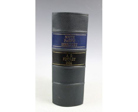
Lot 295
FINDLAY (A), A DIRECTORY FOR THE NAVIGATION OF THE SOUTH PACIFIC OCEAN, 5th edition, folding frontis map, other plates, later 3/4 leather, London, Richard Holmes (1) CONDITION REPORT: Rebound. Frontis map a little worn on outer edge, title page grubby and a little chipped at edge. Xxiii-xxvi chipped at edge, no loss to text. Some foxing and light browning internally.

Lot 301
An interesting collection of World War I and other maps and war maps, to include trench maps of France, a Smiths war map of Zulu Land, a Sifton map of The British Line in Flanders, maps of The Western Front, a Yprey League map The salient, a map of Orange Free State, a map of Southern Rhodesia, two Artillery Training maps, one for St Albans, the other for Berkhampstead, Egyptian Soudan, the Transvaal, Belgium, Italy etc, with two Cycling Maps (Qty)Please note: the few trench maps are printed NOT hand drawn.Provenance: From the collection of Sir Frederic Kenyon (1863-1952). Director of The British Museum and head of the committee who recommended the layout of the war graves in 1918 after the end of The Great War.


Lot 257
A collection of world travel and interest books, 19th century and later, to include: WILLIAMS (J), A NARRATIVE OF MISSIONARY ENTERPRISES IN THE SOUTH SEA ISLANDS, colour frontis, folding map and other plates, later edition, London, J. Snow, 1837; CAVE (H), THE RUINED CITIES OF CEYLON, London, 1900; CHAPPLE (J), TO BAGDAD AND BACK, Boston, 1928; MCGOVERN (W), JUNGLE PATHS AND INCA RUINS A RECORD OF AN EXPEDITION, 2nd impression, 1928, etc (Qty)
Lot 289
AN ACT FOR MAKING AND MAINTINING A NAVIGABLE CANAL FROM THE RIVER SEVERN AT SHREWSBURY...TO THE RIVER MERSEY, paper covers with later spine, c1793; STEVENSON (D), THE PRINCIPLES AND PRACTICE OF CANAL AND RIVER ENGINEERING, 2nd ed, folding frontis map and other plates, 1872; AN ATTEMPT TO INVESTIGATE THE CAUSE OF THE LATE EXTRAORDINARY CHANGES IN THE BED OF THE RIVER MERSEY, 50PP, lIVERPOOL, 1828 (3)


Lot 484
The Battle for the Falklands. Colourful and superbly illustrated cover showing a map of the Falklands where the most famous battles took place. The cover also illustrates aircraft, helicopters, battleships and troops on the ground. Special 20th Anniversary postmark 2 May 2002. Signed by Rear Admiral James Sam Salt CB Captain HMS Sheffield, sank in the Falklands 1982. Good Condition. All signed items come with our certificate of authenticity. We combine postage on multiple winning lots and can ship worldwide. UK postage from £3.95, EU from £4.95, Overseas from £6.95

Lot 485
The Battle for the Falklands. Colourful and superbly illustrated cover showing a map of the Falklands where the most famous battles took place. The cover also illustrates aircraft, helicopters, battleships and troops on the ground. Special 20th Anniversary postmark 2 May 2002. Signed by Vice Admiral Sir John Coward KCB, DSO HMS Brilliant, Falklands 1982. Good Condition. All signed items come with our certificate of authenticity. We combine postage on multiple winning lots and can ship worldwide. UK postage from £3.95, EU from £4.95, Overseas from £6.95

Lot 495
Series Cover The Falklands Conflict. HMS Endurance Sails for South Georgia, 21st March 1982. Cover design features a map of the Falkland Islands and HMS Endurance Issued with Firm Rules of Engagement, 24th March 1982. Special postmark 25th Anniversary of the Falklands Conflict, Portsmouth, 21 March 2007. Signed Lt. Cdr. J. A. Tony Ellerbeck DSC Flight Commander HMS Endurance, 1982. Good Condition. All signed items come with our certificate of authenticity. We combine postage on multiple winning lots and can ship worldwide. UK postage from £3.95, EU from £4.95, Overseas from £6.95
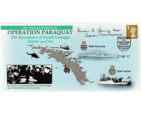
Lot 498
Series Cover The Falklands Conflict. Operation Paraquat The Recapture of South Georgia 25th 26th April 1982. Cover features a map of South Georgia, Royal Navy Ships HMSs Plymouth and Antrim and a hermes archive photograph of the surrender by the Argentine Commanding Officer. Special postmark 25th Anniversary of the Falklands Conflict, Portsmouth, 3 April 2007. Signed Captain Brian Young DSO Commanding Officer of HMS Antrim. Good Condition. All signed items come with our certificate of authenticity. We combine postage on multiple winning lots and can ship worldwide. UK postage from £3.95, EU from £4.95, Overseas from £6.95

Lot 131
A large collection of mostly original WWII Second World War newspapers, magazines & story clippings to include; Picture Post Tunis Victory, repro 'The Downfall Of The Dictator Is Assured' poster, Daily Mail 'War Map', Air Raid Casualty Report, small cotton Union Flag, British Government 'Letter To The Arab People', Daily Telegraph 'Map Of Germany', 'A Guide To The Preservation Of The Life At Sea After Shipwreck, various telegrams, repro 'We Want Your Kitchen Waste' poster, various government information booklets, food card, Atomic Bomb newspaper report etc

Lot 168
An original WWII Second World War British uniform together with a Johnson & Johnson 1944 First Aid bag with unused shell dressings inside, officers canvas map case (still retaining the original pencils and ruler in miles & inches), 2x rare Sten gun / machine gun magazine pouches, one of which contains three empty magazines.

Lot 245
An original antique likely Railway issue ' Shropshire & Montgomeryshire ' Railway line map. Printed on a semi-translucent material, the map details the railway line, including stations and various boxes of information. Framed, within an original railway hanging frame. Measures approx; 56cm x 69cm.


Lot 90
A collection of WWII Second World War relating items belonging to L. Withers of 59 Millground Road, Withywood, Bristol to include; WWII medal group comprising of Defence Medal, 1939 - 1945 War Medal, Italy Star, 1939 - 1945 Star, Africa Star & France & Germany Sta. Within their original medal & on original ribbons. Also to include various pieces of related ephemera; bank notes from Syria, Japanese Government 100 Rupees, Belgium Frank, Lebanese £25, Deutschland Mark & Rentenmarks, Italy Lire & Ceylon Fifty Cents. Christmas 1944 meal menu, Solider's Guide To Sicily, Guide to Military Urdu, Arabic yearly diary, Map of Jerusalem from the Town Major's Office German Colony with the ' do's & don't whilst on leave ' & a military issued 'The Little Bible'.

Lot 1061
Mitchell, Samuel Augustus, "Mitchell's Travellers Guide through the United States", Philadelphia, 1832, first edition, hand-colored, tissue backed, originally a pocket map that covered the United States west to the Mississippi River, nine insets, feature Philadelphia, Washington, Charleston, Boston, New York, Cincinnati, Albany, New Orleans and the Niagara Falls area, 21 1/2 in. x 17 1/4 in
![[Civil War Map], Perrine, Charles O., "Perrine's New Topographical War Map of the Southern States", Indianapolis, Indiana / B](https://cdn.globalauctionplatform.com/59cd3087-0793-4b93-a3f3-a823010e234f/bfae1b3a-9720-457c-cbd1-318f1dc59dbe/468x382.jpg)
Lot 1062
[Civil War Map], Perrine, Charles O., "Perrine's New Topographical War Map of the Southern States", Indianapolis, Indiana / Buffalo, Jewett & Co., New York, 1863, printed in colors, folding case map of the Southern States with small red circles indicating the sites of major Civil War battles, 36 1/2 in. x 28 in
Lot 373
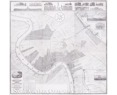
Charles F. Zimpel (Prussian/American, 1801-1879), "Topographical Map of New Orleans and its Vicinity, Embracing a distance of twelve miles up and eight and three quarter miles down the Mississippi River and Part of Lake Pontchartrain, representing all Public Improvements existing and projected and important Establishments, accompanied by A Statistical Table, containing the most accurate Illustrations; prefaced by A Splendid View of New Orleans, & Compiled from actual surveys and the best authorities, by Chas. F. Ximpel, Deputy City Surveyor of New Orleans, Chief Engineer of the New Orleans & Carrollton Rail Road Company and late Engineer in the Prussian Service, Scale six inches to the mile, New Orleans March 1834", lithograph, on six sheets, original folio, vignettes showing: Orleans Cotton Press Co., City Hotel, Levee Steam Cotton Press, City Hall (Cabildo), St. Louis Cathedral, Presbytere, Bank of the Canal and Banking Co., City House and Market of the City of Lafayette, Bank of New Orleans, Union Bank, American Theater, Sugar Refinery, Charity Hospital, State House, "Defeat of the British Army...", "Plan of the Banks of the Mississippi and Adjacent Country...", and "Mouth of the Mississippi at the South West Pass", six sheets (combined) 63 in. x 64 in. Note: Zimpel, Charles F. (Karl Frederick Zimpel) and the subject map are best summarized in Ellen Merrill’s Germans of Louisiana. Pelican Publishing Company, Inc. 2005: “Zimpel was a young Prussian aristocrat who soon established a lucrative career in the city as a surveyor, engineer, and architect. His tastes were mainly classical, in keeping with the style in vogue in both Europe and America. He was highly successful in those areas in which he was trained and, for a short time, became deputy surveyor and chief engineer for the city. In 1833 he laid out and developed the City of Carrollton. Perhaps his most important achievement was the detailed map of New Orleans he produced in 1834. Dissatisfied with the quality produced by the lithographers in New Orleans, he sent his original drawing back to Germany. On the return trip the lithographic stone and reproductions were lost at sea, making the Zimpel map a collector’s item. As chief engineer of the New Orleans and Carrollton Railway, which ran from Canal Street to Carrollton Avenue along Nayades Street (now St. Charles Avenue), he got involved in land speculation. Having little experience in this area, he soon fell into debt and fled the city. After only seven years of working in New Orleans, he returned to his native Prussia.” Zimpel also designed and oversaw construction of several important buildings in New Orleans during his tenure here, three of which are shown in vignettes above his map: the Bank of New Orleans, City Hotel, and the Orleans Cotton Press. Only six copies of the Zimpel map have been located, five of which are housed in institutional collections.


Lot 380
Bellin, Jacques Nicolas, "Karte von Luisiana, dem Laufe des Mississipi und den benachbarten Laendern...", Leipzig, 1744/1758, hand-colored, German text edition by Bellin of De L'Isles's famous southeast map covering most of the eastern half of North America from the Great Lakes to the Gulf of Mexico; European colonies and possessions along the Atlantic and Gulf coasts are depicted along with Indian lands, 15 1/2 in. x 22 1/4 in

Lot 529
Barbe-Marbois, Marquis Francois de, Histoire de la Louisiane et la Cession de Cette Colonie par la France aux Etats-Unis de l'Amerique Septentrionale..., Paris, Firmin Didot, 1829, octavo, first edition, modern quarter calf, with scarce hand-colored map of the Louisiana Purchase Note: Barbe-Marbois, "The man who sold Louisiana," became Napoleon's Secretary of the Treasury in 1801. In 1803 he was appointed to sell Louisiana to the United States for 50 million francs, but negotiated a higher price of 80 million, for which he was liberally rewarded by Napoleon.

Lot 535
Sartine, Antoine, "Carte D'Une Partie des Cotes de la Floride et de la Louisiane...", Paris, 1778, Revolutionary War era map of the North Gulf Coast area from the confluence of the Red River with the Mississippi River to the Apalachicolas River in Florida, the map was intended for use by the French Navy during the Revolutionary War, 16 in. x 23 in
![[French Map of the Gulf of Mexico], "Carte du Golfe du Mexique dresse par Mr. Keller", Paris, Depot General de la Marine, 184](https://cdn.globalauctionplatform.com/59cd3087-0793-4b93-a3f3-a823010e234f/85fb9ba8-0286-4d06-8594-4dec54fd4253/468x382.jpg)

Lot 625
Mitchell, S. Augustus, "Map of the States of Louisiana Mississippi & Alabama", Philadelphia, engraved by J.H. Young, 1831/1839, hand-colored, originally issued as a pocket map, linen backed upper left corner with tables of "Steam Boat Routes and Principal Stage Routes, Through The States of Louisiana, Mississippi & Alabama, with the number of runs per week given, 17 1/2 in. x 22 5/8 in

Lot 680
Darby, William, A GEOGRAPHICAL DESCRIPTION OF THE STATE OF LOUISIANA: PRESENTING A VIEW OF THE SOIL, CLIMATE, ANIMAL, VEGETABLE, AND MINERAL PRODUCTIONS_WITH AN ACCOUNT OF THE CHARACTER AND MANNERS OF THE INHABITANTS...BEING AN ACCOMPANIMENT TO THE MAP OF LOUISIANA, printed for the Author, and Published by John Melish, Philadelphia, 1816, first edition, octavo, modern 1/2 morocco and marbled boards, spine gilt with raised band


Lot 397
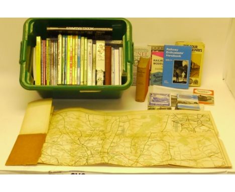
Collection of Railway-related Books and Maps, including 'The Splendid Book of Empire Railways, BR Operating manual for Sulzer locomotives D5176 and D7500, RH&DR 1946 timetable and guide, Ian allan ABC's of Narrow Gauge and Model Railways, all VG, with many others, a March 1935 map of London a Suburbs railways including 'big four' and LPTB lines (F, some creases split and cover missing) and four 6" x 8" photographs by Rev PJ Morse (3) and HC Casserley (1), mostly G (qty)


Lot 224
MASTERS JOHN. The Compleat Indian Angler. Col. frontis. Plates. Quarto. Orig. cloth, rather worn, internal spotting & foxing. 1938; also The North Punjab Fishing Club Anglers' Handbook, fldg. map with tape reps., reps. & stng. to early pages, 10 plates (misbound), green cloth, 2nd ed., Calcutta, 1890; 3 others re. Indian angling & one other. (6).

-
109182 item(s)/page