We found 108737 price guide item(s) matching your search
There are 108737 lots that match your search criteria. Subscribe now to get instant access to the full price guide service.
Click here to subscribe- List
- Grid
-
108737 item(s)/page


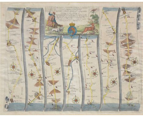
Lot 348
John Ogilby, Road from London to St Neots .. continued to Oakeham, 36x47cm; Emmanuel Bowen, Road from Hereford to Leicester, including a small map of Leicestershire; Emmanuel Bowen, The Road from London to Norwich, incorporating a small map of Rutlandshire; and a distances chart from Jacob Van Langeren, (4).


Lot 637
EMANUEL BOWEN 'DORSET SHIRE' dedicated to the Right Hon. Anthony, Earl of Shaftesbury, published by John Tinney for John Bowles & Son, hand coloured engraved map, 60cm x 76cm (unframed); together with a similar unframed map of the County of Dorset surveyed by Isaac Taylor, published by Faden, July 1st 1796, 57cm x 79cm (2)


Lot 204
JOHN SPEED uncoloured engraved map of Wales, John Sudbury and George Humble, dated 1610, twelve oval vignettes of principal cities of Wales to the vertical margins, inset views of Bangor, St Davids, Llandaff and St Asaph, English text verso, 42 x 52cmsProvenance: deceased estate GwyneddComments: framed and glazed both sides


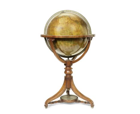
Lot 617
A Thomas Malby & Son 18-inch Terrestrial Library Globe, English, Second half 19th century,the cartouche printed MALBY'S TERRESTRIAL GLOBE Compiled from the latest AND MOST AUTHENTIC SOURCES, INCLUDING ALL THE RECENT Geographical Discoveries Manufactured and Published under the superintendence of the SOCIETY FOR THE DIFFUSION OF USEFUL KNOWLEDGE BY MALBY & SONS GLOBE & MAP SELLERS TO THE ADMIRALTY, the terrestrial globe mounted in brass meridian within horizon ring applied with printed zodiac and calendar scales, supported on three curved mahogany legs, with stretcher compass, without casters, globe 18in (46cm) diameter40in (101.5cm) high overall Footnotes:Thomas Malby's map & globe firm continued under the stewardship of his son from 1851, who was was still recorded as operating in business in 1884. Thomas Malby closely linked himself with the Society for the Diffusion of Useful Knowledge, as a way of marketing his products to the rising middle class of Britain.This lot is subject to the following lot symbols: TPTP For auctions held in Scotland: Lots will be moved to an offsite storage location (Constantine, Constantine House, North Caldeen Road, Coatbridge ML5 4EF, Scotland, UK) and will only be available for collection from this location at the date stated in the catalogue. Please refer to the catalogue for further information.For all other auctions: Lots will be moved to an offsite storage location (Cadogan Tate, Auction House Services, 241 Acton Lane, London NW10 7NP, UK) and will only be available for collection from this location at the date stated in the catalogue. Please note transfer and storage charges will apply to any lots not collected after 14 calendar days from the auction date.For further information on this lot please visit Bonhams.com


Lot 519
Frank Bowling is a Guyanese-born British artist known for his contributions to contemporary painting. Here are key points about Frank Bowling:1. **Early Life:** Frank Bowling was born on February 29, 1936, in Bartica, British Guiana (now Guyana). He moved to London in 1953 to pursue a career in art.2. **Art Education:** Bowling studied at the Royal College of Art in London from 1959 to 1962. He was part of a generation of artists who were challenging traditional artistic conventions.3. **Early Career:** In the early 1960s, Bowling was associated with the School of London, a group of artists that included Francis Bacon, Lucian Freud, and others. During this period, his work reflected influences of abstraction and figuration.4. **Move to New York:** Bowling moved to New York City in 1966, a significant decision that had a profound impact on his artistic development. He became part of the vibrant art scene of the time.5. **Abstract Expressionism:** In New York, Bowling embraced abstract expressionism and developed his own abstract style. He experimented with various materials and techniques, including pouring, staining, and manipulating the paint on the canvas.6. **Map Paintings:** One of Bowling's notable series is the "Map Paintings," created in the late 1960s and early 1970s. These works incorporated map-like elements, exploring the relationship between abstraction and representation.7. **Poured Paintings:** Bowling is known for his innovative use of poured paint, allowing the paint to flow and create intricate textures on the canvas. This technique became a hallmark of his practice.8. **Recognition:** Bowling received recognition for his contributions to contemporary art. In 2005, he was appointed a Commander of the Order of the British Empire (CBE) for his services to art.9. **Later Career:** Bowling continued to evolve as an artist, exploring new techniques and themes. His later works often feature vibrant colors and dynamic compositions.10. **Retrospectives and Exhibitions:** Bowling's work has been featured in numerous solo and group exhibitions worldwide. Retrospectives of his art have been organized to celebrate his career and influence on contemporary painting.11. **Legacy:** Frank Bowling is celebrated for his groundbreaking contributions to abstract painting, his experimentation with materials, and his exploration of cultural and personal themes. His work is held in major museum collections.Frank Bowling's career reflects a commitment to pushing the boundaries of painting and engaging with abstraction in innovative ways. His influence extends beyond his artistic achievements, as he continues to inspire contemporary artists exploring the possibilities of abstract expression.Measures 40 x 23.5.


Lot 890
The Iliad by Homer. In Greek and Latin. Edited by Samuel Clarke. Published 1826 by Duyckinck, etc., New York. Books are bound in brown leather with gilt titling on a field of red on the spine. With map. 8vo. Approximate Dimensions:Each book: h. 8.75", w. 5.5", d. 1.25"Condition:Books have wear on the leather and boards from age and shelving. Some worm tracks on front boards. Pencil marks and marginalia present on both volumes. Some pages having toning and tearing in spots. Moderate foxing. Bookplate of a previous


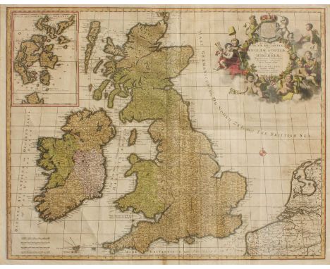
Lot 108
Allard (Carolo), Regnorum Magnae Britanniae Sive Angliae Scotiae nec non Hiberniae..., no date, hand-coloured engraved map of Britian and Ireland, with cartouche and inset map of the Orkney Islands, framed and glazed; with an Elizabethan fine indenture, dated at Westminster, May 1568, ink on vellum (2)Somewhat browned, very light dust marking in places, creases in addition to central fold. Not examined out of frame.
![Military Posts--Council Bluffs to the Pacific Ocean. 27th Congress, 2nd Session. House Document, no. 830. [Washington, D.C.],](https://cdn.globalauctionplatform.com/440e8d48-84c8-4d82-9c12-b103013acfb6/13f176c8-e68b-47a3-85e0-b103014d451f/468x382.jpg)
Lot 384
Military Posts--Council Bluffs to the Pacific Ocean. 27th Congress, 2nd Session. House Document, no. 830. [Washington, D.C.], 27 May 1842. Written by Nathaniel Greene Pendleton (1793-1861). Contains a map. Approximate Dimensions:h. 9", w. 5.75"Condition:Previously bound but has been unbound. Some wear to pages with light staining and yellowing. Pencil marks on front page.

Lot 391
The Gentleman’s Magazine, 1755. An early mention of George Washington in a London magazine. A report, reading in part: "The poor men who suffered at the meadows with Colonel Washington recommend to your favour as they were disabled in the service of their country...". This is very early & rather unusual mention of George Washington, being just 23 years old. The additional high points in this issue are first an article headed: "Gov. Dinwiddie's Speech to the Assembly of Virginia" in which he relates various reports from the French & Indian War, including mention of "...general Braddock, commander in chief of all his majesty's forces on this continent..." and others. The very first article in this magazine: "Account of the British Settlements in N. America" which is continued from a previous issue & takes over 3 1/2 pages. Among other items of interest in this magazine are: "A Message from his Excellency Arthur Dobbs, Esq., Governor of North Carolina, to the General Assembly held at Newburn (New Bern)," "A Particular Account of the Death of Mr. Professor Richmann...who was Killed Whilst he was Making an Electrical Experiment" which also includes two illustrations. "Journal of Public Transactions in America," an article which begins: "In the instruction given by Somerset County in Virginia to the representatives in the assembly, is the following passage..."; a full back page is a chart of: "Each Day's Price of Stocks in July, 1755" and much more. The American map called for is lacking. The page numbers are 244-335, plus one each a title page of St Johns Gate. With full title/index page featuring an engraving of St. John's Gate. Bound with June 1755 having a highlight of the dispute between the Assembly and the Governor of Pennsylvania. Speeches of Indian chiefs and a nice description of shells with an illustration. Many snippets of America, including a description of the penalties for anyone to visit Louisbourg, the capital of the French province of Île-Royale (present-day Cape Breton Island) during the War of the Austrian Succession, known as King George's War in the British colonies. Had they visited in a four-month period, the sentence was to have one’s ear cut off, 39 lashes and seizure of assets and exclusion from government.Approximate Dimensions: h. 8", w. 5"Condition:Bound together in excellent condition with the original binding string. American map is not present.

Lot 420
The Political Magazine And Parliamentary; Naval, Military, and Literary Journal, for the year 1780, Volume 1, (2),56pp., with a fold out map of Gibraltar's fortifications. Printed by Bew J. London, 1780 Approximate Dimensions:h. 8.1875", w. 5.25"Condition:This has been previously bound with some calf left on the spine. Bindings are strong and the pages are very clean overall with just a little toning on the edges.

Lot 433
A copper engraved map titled "A View of the Town and Castle of St. Augustine and the English Camp before June 20th 1740, by Thomas Silver. With a numbered key panel and text, "Account of Siege of St. Augustine", London, c.1741. Early piece of Florida history. Framed in archival mounting and protective glass and a brownish black frame with intricate design on front edges. After the War of Jenkins Ear erupted in 1739, James Oglethorpe, the Governor of Georgia, was ready to take the initiative. In 1740, he assembled an invasion force consisting of his regiment, Indian allies, Carolina Rangers, and several ships in the Royal Navy. His goal was the Spanish fortress at St. Augustine. Unfortunately, the siege failed and the allied force fell apart, forcing a dejected Oglethorpe back to St. Simons Island to await the Spanish counterattack that would surely follow. Approximate Dimensions:Piece: h. 1.625" w. 6.4375"Condition:Minor folds with some marginal strengthening on verso. Comes with two photocopied pages with history of the fort and siege. Some small chips to frame on high points of which are not very distracting.

Lot 442
Volumes 3 and 4 of L’Histoire de L’Amerique by William Robertson. Printed 1780 by Pissot, Paris. Includes 2 maps, one is a map of the Americas (New Mexico) and Mexico, and the other is a map of Mexico and the South American coast of the Pacific Ocean. Also, a fold out chronological table. Bound in leather with gilt titling and decoration on the spine. Blue marbled page edges. Approximate Dimensions:Each book: h. 6.75", w. 4", d. 1.25"Condition:Boards have wear and scuffing with the map of the South American coast having a 2 inch plus tear on the upper left side. Other fold outs are in good condition with the map of Mexico having some wear to edge as it sits outside the other pages a

Lot 478
America sive India Nova ad magnae Gerardi Mercatoris avi Universalis imitationem in compendium redacta. By Michael Mercator (1565/70-1614.) We believe it to be Amsterdam: Hondius, circa, 1628. Copper-engraved map, early hand-coloring. Roundels at each corner with inset maps of the Gulf of Mexico, Cuba and Hispanola, the remaining containing the cartouche. Framed Approximate Dimensions:Entire piece: h. 16", w. 20",Condition:Center folding line shows some splitting and repairs of which show at the top and in the middle and looks to have been reinforced from the verso. General overall age toning with a few foxing spots. Colors are bold and complete. There is a

Lot 511
Six English periodicals with news items about the colonies. Examples date from 1733 to 1783. #1: The Gentleman's Magazine dated April 1733 containing a descriptive letter from General Oglethorpe to the trustees describing Savannah and how they will set it up. With much other news spanning pages 165-220. #2: A supplement of The Gentleman’s Magazine for 1742, with pages 665-698 containing 5 pages describing the Spanish invasion of Georgia with the last page categorizing complete mortality rates, numbers and causations in London. #3. then on to The Gentleman’s Magazine for January 1756, containing 2.5 pages of text describing New Georgia and an account of news between the governor and the assembly of Philadelphia. With much more news. #4. The Gentleman’s Magazine dated April 1779, pages 161-216, with discussion concerning Georgia in a Lieutenant Colonel Campbell’s letter to Lord George Germaine as well as General Provost’s letter to the same, with a wonderful fold out map of the attack plan on St. Lucia with much detail. #5. An appendix to the London Magazine for 1783 with a strong and very early account of the Treaty of Paris which was signed September 3rd, 1783, and state papers. #6. The Gentleman's Magazine of 1779, month unknown because of a missing cover, with a great deal of detail describing Major General Provost’s "Journal of the Siege of Savannah" with almost 5 pages of strong details.Approximate Dimensions: h. 8.25" w. 5.1875:"Condition:All have been previously bound with some calf leather still attached. Clean with minimal foxing spots and toning. The 1742 example is toned overall.
Lot 537
The Cherokee Land Lottery, Containing A Numerical List of the Names of the Fortunate Drawers in Said Lottery with An Engraved Map of Each District by James F. Smith of Milledgeville, GA. Published 1838 by Harper and Brothers. First and only edition. A list of names with maps showing the land taken from the Cherokee. This land would have been awarded after the forced relocation of the Cherokee tribe in 1838. Book is fully bound in brown leather. The spine has gilt titling on a field of red. Advertisements in the back. Book comes with a blue cardboard case. Approximate Dimensions:h. 9", 5.75", d. 1.25"Condition:Wear, rubbing, and loss to leather boards. Pages have some light staining and foxing.
Lot 538
Travels Through North and South Carolina, Georgia, East and West Florida, The Cherokee Country. The Extensive Territories of the Muscogulges or Creek Confederacy, and the country of the Chactaws, Containing An Account of the Soil and Natural Productions of Those Regions, by William Bartram. Published 1793, J. Moore, W. Jones, R McAllister and J. Rice, Dublin. Early edition. Book is an extensive account of Bartram's travels through the Southeast of the United States. Book has detached front board and missing back board containing the frontis and 6 copper plate illustrations are all present. missing map 8vo. 520pp. with index.Approximate Dimensions:h. 8.5", w. 5.5", d. 1.5"Condition:Front board has detached and back board is missing. Spine has split. Book is in two pieces but still has all pages.
![The Travels of Capts. Lewis & Clarke [sic], by order of the government of the United States, performed in the years 1804,](https://cdn.globalauctionplatform.com/440e8d48-84c8-4d82-9c12-b103013acfb6/129597ae-bc60-4fa6-8d16-b103014f6ced/468x382.jpg)
Lot 545
The Travels of Capts. Lewis & Clarke [sic], by order of the government of the United States, performed in the years 1804, 1805, & 1806, being upwards of three thousand miles, from St. Louis, by way of the Missouri, and Columbia Rivers, to the Pacific Ocean: containing an account of the Indian tribes, who inhabit the western part of the continent unexplored, and unknown before. With copious delineations of the manners, customs, religion, &c. of the Indians. Compiled from various authentic sources, and documents. To which is subjoined, a summary of the statistical view of the Indian Nations, from the official communication of Meriwether Lewis. Printed 1809 by Hubbard Lester, Philadelphia. Brown leather boards with titling on the spine. One folding engraved map (11 1/4 x 9 inches), 1 stipple engraved frontispiece by W.R. Jones, 4 unsigned etched plates with roulette work. Provenance: Amos Chapel of Newmarlbourough inscribed on second front paper. Howes 1321; Literature of the Lewis and Clark Expedition 4a.1; Pilling Proof-sheets 2282; Sabin 96499; Shaw & Shoemaker 17911; Streeter sale 3122; Wagner-Camp 8:1Approximate Dimensions:Condition:Boards and leather have wear and scuffing. Repair has been made to the map, roughly 1/4 of original map remains with a later copy inserted to finish out full map. Page 13 has bottom right corner off affecting some letters. Page 110 has some edge

Lot 569
Two books by Joseph M. Brown: #1: The Mountain Campaigns in Georgia, or, War Scenes on the W. & A. Published 1886 by Art-Printing Works of Matthews, Northrup & Co., Buffalo, New York. First edition. 64,[1] pp. Frontis., illus., map. Orig. pictorial wrappers. #2: Kennesaw's Bombardment, How the Sharp Shooters Woke Up the Batteries. Published 1890 by Record Publishing Company, Atlanta. First edition. (1), [172 p.p.], (1). Joseph Mackey Brown (December 28, 1851 – March 3, 1932) was an American politician. He served two non-consecutive terms as the 59th governor of Georgia, the first from 1909 to 1911 and the second from 1912 to 1913. Approximate Dimensions: h. 10.75" w. 8.25" Kennesaw h. 7.25:" w. 5.0"Condition:The Mountain Campaigns: the front cover and the first two pages have a split on the hinge coming 1/2 the way down the pages. Scattered discoloration on the front cover with a removed price sticker at the upper right corner. Verso has

Lot 579
Address of His Excellency John A. Andrew, to the Legislature of Massachusetts, Together with Accompanying Documents. January 8, 1864. Complete with fold out map of Soldiers National Cemetery at Gettysburg. Published January 8, 1864 by Wright and Potter. Antique-style three-quarter calf and marbled boards. 19th-century ink stamp on title page and contemporary inscription on second leaf. Internally clean. Devoted almost entirely to the Massachusetts war effort, published early in January 1864. The folding map shows the Soldier's National Cemetery at Gettysburg, dedicated Nov. 19, 1863, with the long speech of Edward Everett of Massachusetts and the short "Dedicatory Speech by President Lincoln," better known as the Gettysburg Address. Also printed is the "Programme of Arrangements" of that day, a list of Massachusetts soldiers killed at Gettysburg and buried there, and details of the cemetery. Monaghan notes this as an early printing of the Gettysburg Address. John Albion Andrew (May 31, 1818 – October 30, 1867) was an American lawyer and politician from Massachusetts. He was elected in 1860 as the 25th Governor of Massachusetts. 110pp. With custom case. Approximate Dimensions:h. 10.5", w. 6.75"Condition:Some wear to original wrappers with some minimal paper loss on the cover and spine. Pages look mostly clear. Fold out map of Gettysburg has some pinhole tears at the folds.

-
108737 item(s)/page