We found 109198 price guide item(s) matching your search
There are 109198 lots that match your search criteria. Subscribe now to get instant access to the full price guide service.
Click here to subscribe- List
- Grid
-
109198 item(s)/page


Lot 1131
CRAGGANMORE 1990 DISTILLERS EDITIONActive. Ballindalloch, Banffshire. Finished in port casks, bottled 2003. 70cl, 40% volume, in carton. ROYAL BRACKLAActive. Nairn, Inverness-shire. 70cl, 40% volume. CLASSIC MALTS MINIATURE PACKTo include Talisker 10yo (map label), Oban 14yo, Glenkinchie 10yo, Dalwhinnie 15yo, Lagavulin 16yo (WHD) and Cragganmore 12yo. 6 bottles. GLENMORANGIE MINIATURE TWIN PACKTo include 10yo and Port Wood Finish. 2 bottles. 4 items. CONDITION REPORT: Damage to Royal Brackla label. Fill levels in Classic Malts pack are below shoulder. Viewing recommended.

Lot 1192
GLENFIDDICH 12 YEARS OLDActive. Dufftown, Banffshire. 70cl, 40% volume, in tube. GLENLIVET 12 YEARS OLDActive. Ballindalloch, Banffshire. 70cl, 40% volume, in box.CLASSIC MALTS MINIATURE PACKContains Talisker 10yo (map label), Oban 14yo, Glenkinchie 10yo, Dalwhinnie 15yo, Lagavulin 16yo (White Horse Distillers) and Cragganmore 12yo. 6 bottles, all 5cl.GLENMORANGIE 10CL PACK. Active. Tain, Ross-shire.To include 10yo (40% volume), Port Wood Finish (43% volume) and Burgundy Wood Finish (43% volume). 3 bottles in gift pack. 4 items. CONDITION REPORT: Fill levels of Classic Malts minis in shoulder. Otherwise all items very good condition.


Lot 392
JOHN & CHRISTOPHER GREENWOOD 'Map of the County of Sussex from an actual Survey made in the years 1823 & 1824' engraved view by H. FROST with hand coloured detail, inset view of Chichester Cathedral, originally published in first edition of 'Greenwoods' Atlas of the Counties of England' Some areas of minor foxing and fading, colour areas a little faded, visible fading down fold mark


Lot 351
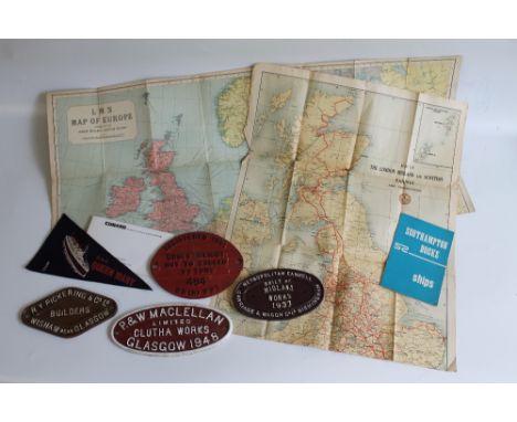
FOUR RAILWAY WAGON PLATES, a Metropolitan Cammell Carriage and Wagon Co. Ltd Birmingham 1937, PW Maclellan Ltd Glasgow 1948, R.Y.Pickering and Co. Ltd Glasgow and B.R (W) 22T 484 1961. Together with a small collection of Queen Mary memorabilia, including a guide book, also an L.M.S. map of Europe, etc.
Lot 211
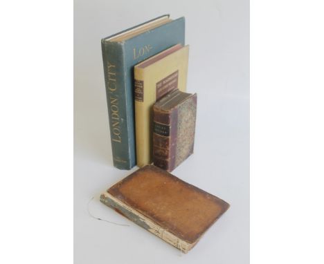
LOCAL GUIDES II' - BOUND IN ONE VOLUME - 'Hardy's Strangers' Guide Through Dublin' (missing title pages), 'Fraser's Guide to Liverpool (includes folding map A/F, and missing title pages), 'Shuttleworth's Guide Book to Ilkley and Vicinity' second edition, 'A Pictorial Guide to Birmingham' 1849 (includes folding map A/F) together with Alex Chalmers - 'A History of the Colleges, Halls & Public Buildings, attached to the University of Oxford' 1810, W. J. Loftie - 'London City' 1891, Michael Fairless - 'The Roadmender' 1950 (4) Condition Report:Please note: every page of every book is not checked, if you are unable to view yourself please ask for detailed information
Lot 205
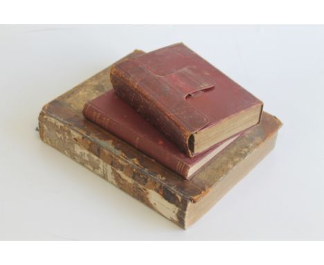
CARY'S NEW ITINERARY; or, an Accurate Delineation of the Great Roads...', 1798, includes folding map of England, Wales and part of Scotland A/F, red calf together with a plan of Manchester & Salford A/F, together with Alexander Campbell - 'A Journey from Edinburgh through Parts of North Britain'Vol. I only 1802 - missing back board and 'The Prose Works of Rev. R. S. Hawker, Vicar of Morwenstow including footprints of former men in far Cornwall' 1893 (3) Condition Report:Please note: every page of every book is not checked, if you are unable to view yourself please ask for detailed information
Lot 213
T.BOWEN Map of Poland for Barlow's General History of Europe, coloured steel engraving, framed, 45cm x 35cm. CONDITION REPORT: Glass very dirty so appears worse than it is. Impression of plate can be seen. Small margin 1/2cm-1cm. Overall fairly good condition. Staining bottom right. Has four lateral fold marks. Colours good and bright. Paper wavy, unsure if pasted down. It is float mounted. Some minor marks/discolouration to the print as a whole.

Lot 215
JOHN SPEEDE New Map of Poland, annotated to scaled key 'a humble 1626', framed, 54cm x 24cm, Edward Gordon label verso. CONDITION REPORT: Centre fold. Rather brown overall. Margin cut close on horizontal tear to paper margin top right c6cm/bottom edge. Pieces of card/thick paper to right hand side and left hand side. Colours slightly faded to margins and very faded to map. Paper rather dirty. Plate impression visible. Top right hand corner margin is missing. Small tear mid-left from edge into Polonian woman c3cm.

Lot 255
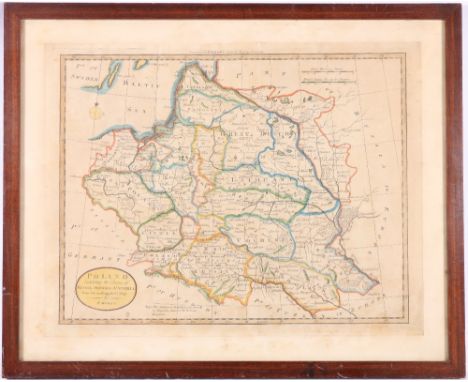
An early 19th century wooden dissected puzzle, a New Map of the World, oak case with sliding lid, published William Darton Jnr, London, and A New Map of Europe, 19th century dissected puzzle, published George Philip & Son, London, wooden box & sliding cover. (2) CONDITION REPORT: Map of Europe has 1 piece missing and 1 piece broken. Map of World appears complete

Lot 214
Homanno (Johann Baptiste): 18th century Map of Poland and Lithuania, coloured steel engraving, framed, 60cm x 50cm. CONDITION REPORT: Framed and glazed, glass broken. Colour good, staining particularly to bottom left corner and bottom right corner. Slight foxing top left of margin. Central fold. Paper wavy. Staining to right hand side of map and margin. Slight marking to title top left, dirty/dark scrape mark, foxed at rear of REGNI. Plate mark visible. Small hole to top left c3mm x 4mm outside margin. Both left and right hand sides appear in-glued, cannot tell if top and bottom are glued.
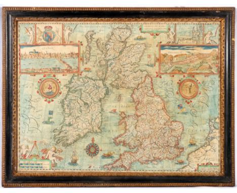
Lot 216
JOHN SPEEDE Map of 'The Kingdome of Great Britain and Ireland' to be sold by 'The Bafsett in Fleet Street and Ric Chifwell in St Pauls church yard', framed, 50cm x 38cm. CONDITION REPORT: Map very bumpy. Frame is to the edge of the print. Slightly yellowed in some areas particularly centrally and on the right. Central fold, slightly dirty/yellowed. Colour fairly good, slightly dull, slightly rubbed. Overall slightly brown colour. Not sure if glued/pasted down at edges. Very small tear at the T in South on bottom edge. This is an original
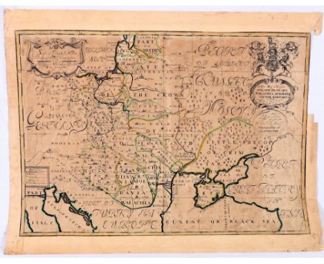
Lot 217
New map of Poland, Hungary, Walachia, Moldavia little Tartary dedicated to his Highness William Duke of Gloucester, coloured engraving, unframed, 51cm x 36cm. CONDITION REPORT: Unframed. Top right hand mount is missing. Map is cut tight to black/yellow border. Centre fold, small worm hole (crescent shape) c8mm at top of fold. Rather brown overall. Repair/patch in to bottom right hand corner. Crumpling to paper top right hand corner. Pasted along top edge, centre right to backing and bottom. Some foxing to map. Repaired tear to Gulf of Riga on top margin c5cm. Small repair to mid-centre bottom margin c1cm.

Lot 703
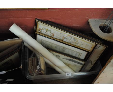
A collection of land surveys, maps, plans and posters including 'A Survey of The Manor of Croxley and Snells Hall...In The County of Hertford Belonging to Gonville and Caius College...University of Cambridge' (x2), a Macpherson's cloth mounted map of Inverness and the Northern Highlands, etc.
Lot 704
A collection of railway ephemera including photographs, negatives, CDs, plastic model kit components, two John Paige train friezes and a quantity of railway books, magazines and pamphlets, including 'The Railways of Britain' by Jack Simmonds, a Bartholomew 'Railway History Map of Britain', etc.

![AFTER ROBERT MORDEN; an 18th century map 'Darbyshire' [sic], 36 x 43cm, framed and glazed.](https://cdn.globalauctionplatform.com/1c51a0f0-343b-44f9-badf-a7c1012ab2a1/8a78999c-be26-4fe1-f120-74f6ed690bef/468x382.jpg)

Lot 768
AFTER ROBERT MORDEN; two 18th century hand coloured maps of Cumberland and the County Palatine of Lancaster, both hand coloured, plus a further map of Cumbria and a Bowles's map of Cumberland and Westmorland, and a map of the south part of Scotland and The Lake of Derwent, all six framed and glazed, two unframed maps and a small collection of ordnance survey maps and two Bartholomew's maps of the Lake District.

-
109198 item(s)/page