We found 109182 price guide item(s) matching your search
There are 109182 lots that match your search criteria. Subscribe now to get instant access to the full price guide service.
Click here to subscribe- List
- Grid
-
109182 item(s)/page


Lot 514
ACE Trains E7/2 0 Gauge (revised version) Castle Class BR apple green 7011 'Banbury Castle' Locomotive and Tender, DC, with instructions, Great Western Map, Red Dragon, Torbay Express, Cornish Riviera and The Bristolian Headboards and protective cloth, in original box, E-M, appears unrun, box VG-E


Lot 1081
TOYNE, S.M, SARK A Feudal Survival, Windsor, The shakespeare Head Press, 1959, map & three full-page line drawings, Pub's original blue cloth, gilt to spine, pictoral dust cover. (scarce) * Condition: Soiled to spine and chipped, dust cover with fading and tear, inner pages with spotting, pencil incription to inner.

Lot 1090
after James Cochrane Junior, a limited edition colour print of, no. 158 from an edition of 250, 'A Map of the Island of Guernsey, likewise all of the Adjacent Rocks, Shoals & Passages, with the Tides, Soundings, Anchorages &c.', dedicated to Lord de Saumarez, Vice Admiral of Great Britain, with vignette of the Royal College of Elizabeth, 22 x 27in. (56 x 68.5cm.).
Lot 1103
Visscher, Nicolas (1618-1679), 'Manica, Gallis La Manche, et Belgis het Canaal...', hand coloured engraved map of the English Channel with the Channel Islands, ornamental title cartouche, compass roses, pub. Amsterdam, 1680, engraved by D. V. Gouwen, 19 x 22¾in. (48.25 x 57.8cm.). * Condition: Not examined out of frame. Some foxing across the paper. Vertical and horizontal centre folds. A few other small creases. Mount burn.


Lot 1211
GENEVA BIBLE"La Bible qui est Toute la Saincte etcriture du Vieil & du Nouveau Testament..."Wood engraved title, headings & initials 15 wood engraved plates many with 2 or more scenes per plate, map of Temple of David. Printed pages appear complete, calf binding in poor condition, folio, Geneve, 1588 (found in loft of the Methodist Church Manse at Baugy Crossroads, Vale, Guensey. Hidden in attic at the time of the German Occupation, purchased from Chapel Stewards by Rev. C. Sutton).


Lot 282
AN EARLY 19TH CENTURY HAND COLOURED MAP depicting the Northern hemisphere, engraved by Kirkwood and produced for John Thomson & Companies New Grand Atlas 12th August 1814, in a contemporary maple effect moulded frame with gilt slip, the hemisphere 50cm diameter Condition: staining to the paper especially to the centre right hand side, central folding crease running horizontally, some signs of foxing, the modern frame in reasonable condition baring a mark to the right hand side

Lot 413
A QUANTITY OF PHOTOGRAPHS AND EPHEMERA, to include assorted Edwardian family photographs, six sets E J Arnold & Sons educational cards regarding maths and money in various types of shops, all contained in original envelopes (c.1950's), boxed Waddy 'Stak-a-Stik' game, Daily Express War Map of Europe etc (contents of card sets and game not checked)


Lot 305
A two-owner, low mileage, very rare, UK-supplied FQ-300...First registered in 2002. 1 of only 7 in Palma RedThe first official FQ UK Evos, the 300s were type approved by Misubishi UKFitted with unique FQ trim, badging and plaquesTuned to 380bhp by Evo Tuner Mark Shead, using an Autronic ECUFitted with Tien Dampers and free flow stainless steel exhaustRecent service and re-map by Mark Shead (£900). 58,000 milesInsurance 'Cat D' in 2009. Superbly repaired and reinstatedYou can now book a one to one appointment (up to one hour) to view this lot at our central location between 17th and 26th June. Please contact Gary Dunne on 07740 946 796 / gary@classiccarauctions.co.uk to secure your appointment or to discuss the car in more detail.The health and safety of both our customers and team remains the utmost priority, we are therefore operating to strict COVID-19 guidelines and full instructions for arrival and inspection protocols will be given when making your appointment.Click here for more informationSpecification:Registration: DF52 BVDYear: 2002Make: MitsubishiModel: Evolution VII FQ-300RHD/LHD: Right hand sideChassis Number: JMYSNCT9A2U000246Odometer Reading: 58000Transmission: manualEngine Capacity: 2Engine Number: 4G63GL8163Body Colour: Palma Red


Lot 782
E.H. ROSS, A CHART OF THE ARCTIC REGIONS, CIRCA 1834, titled "To His Most Excellent Majesty William IVth King of Great Britain Ireland &c. this Chart of the Discoveries Made in the Arctic Regions in 1829, 30, 31, 32 & 33 is Dedicated with his Majesty's gracious permission...", pub. 1834, with six vignettes of coastal profiles visited by Ross, framed. Visible sheet 46cm by 62.5cmThe absence of a Condition Report does not imply that a lot is without imperfections. Please note carefully the exclusion of liability for the condition of lots contained in the Conditions of Sale.A few tears on right of map, fold crease along center, probably slightly faded, frame damaged at a corner and on the right side.


Lot 3183
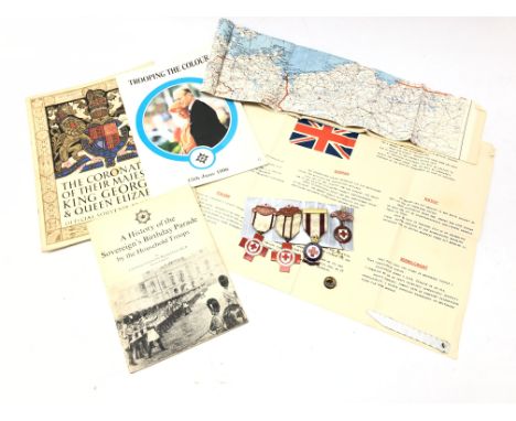
British Red Cross medals to E.C.Halstead, West Riding, Proficiency in Nursing & First Aid, 5 years Service, WWll type pilots silk escape map and Central Europe instructions with compass and saw blade, and programmes for 1937 Coronation, 1966 Trooping the Colour, 1979 Sovereign's Birthday Parade Condition Report Click here for further images, condition, auction times & delivery costs


Lot 133
World War One (WW1) and World War Two (WW2) campaign medals - WW1: War medal and Victory medal, both inscribed to the rim J 80638 A E Lewin Boy 1 R.N.; WW2: 1939-1945 Star, Africa Star with North Africa 1942-43 bar and War medal, also awarded L.S.G.C. medal (missing) served latterly on HMS Avenger, Royal Navy, died on 15th November 1942 aged 41 years - included in lot report of sinking, map of Avenger, copy of service record and more

Lot 22
Official History of the Great War- Military Operations France and Belgium, 1914, Mons, the retreat to the Seine, the Marne and the Aisne, two volumes publ Macmillan, 1922, 32 maps plus plate - condition very good and clean, held in hinged faded red map boxes over stiff board with minor buckling [2]
Lot 243
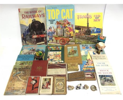
ASSORTED COLLECTABLES comprising an Ordnance Survey folding map of Windsor, circa 1900, red cloth covers; three packs of playing cards, including one of New Zealand and Federal Steamship Companies interest; three Wade ceramic figurines; pen nibs; various childrens books; a Fairylite 'Big Ears' egg cup, boxed; and other items.
![[BOOKS]. TOPOGRAPHY - WILTSHIRE Pitt-Rivers, Lieut.-Gen. King John's House, Tolland Royal, Wiltshire, privately printed, 189](https://cdn.globalauctionplatform.com/58f8c164-35d0-4282-8fda-abac010428c7/4eaa5b61-c208-4fd1-b3d5-abb30121c7d5/468x382.jpg)
![[BOOKS]. TOPOGRAPHY - SOMERSET Burrow, Edward. Ancient Earthworks & Camps of Somerset, subscriber's limited edition 574/](https://cdn.globalauctionplatform.com/58f8c164-35d0-4282-8fda-abac010428c7/45e36af0-d393-4c6d-a6e3-abb30121dffb/468x382.jpg)
Lot 467
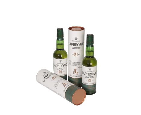
LAPHROAIG SINGLE MALT SCOTCH WHISKY, AGED 21 YEARS, limited edition release to celebrate the 21st anniversary of the Friends of Laphroaig, Isle of Islay, 35cl, 45.4% abv, in carton, 2 btls On the far edge of the Scotch whisky map, it's supposed that the art of distillation was first brought to Islay by Irish monks. Being remote, it's an art that flourished in the hands of the islanders, whose illegal operations tested the resolve and means of the tax man. Eventually, the law relaxed, various whisky makers set up legitimate distilleries, among them a pair of farmers, Donald and Alexander Johnston, who in 1815 founded their distillery on the island's south coast. Laphroaig, so called after its location, 'broad hollow by the bay.' It would remain in family hands for the next 139 years. Distilled in 1993, the year before the Friends of Laphroaig was founded, this whisky was maturing whilst the ranks of afficionados swelled to over 650,000 when bottled in 2015
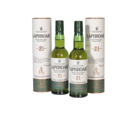
Lot 468
LAPHROAIG SINGLE MALT SCOTCH WHISKY, AGED 21 YEARS, limited edition release to celebrate the 21st anniversary of the Friends of Laphroaig, Isle of Islay, 35cl, 45.4% abv, in carton, 2 btls On the far edge of the Scotch whisky map, it's supposed that the art of distillation was first brought to Islay by Irish monks. Being remote, it's an art that flourished in the hands of the islanders, whose illegal operations tested the resolve and means of the tax man. Eventually, the law relaxed, various whisky makers set up legitimate distilleries, among them a pair of farmers, Donald and Alexander Johnston, who in 1815 founded their distillery on the island's south coast. Laphroaig, so called after its location, 'broad hollow by the bay.' It would remain in family hands for the next 139 years. Distilled in 1993, the year before the Friends of Laphroaig was founded, this whisky was maturing whilst the ranks of afficionados swelled to over 650,000 when bottled in 2015
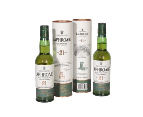
Lot 469
LAPHROAIG SINGLE MALT SCOTCH WHISKY, AGED 21 YEARS, limited edition release to celebrate the 21st anniversary of the Friends of Laphroaig, Isle of Islay, 35cl, 45.4% abv, in carton, 2 btls On the far edge of the Scotch whisky map, it's supposed that the art of distillation was first brought to Islay by Irish monks. Being remote, it's an art that flourished in the hands of the islanders, whose illegal operations tested the resolve and means of the tax man. Eventually, the law relaxed, various whisky makers set up legitimate distilleries, among them a pair of farmers, Donald and Alexander Johnston, who in 1815 founded their distillery on the island's south coast. Laphroaig, so called after its location, 'broad hollow by the bay.' It would remain in family hands for the next 139 years. Distilled in 1993, the year before the Friends of Laphroaig was founded, this whisky was maturing whilst the ranks of afficionados swelled to over 650,000 when bottled in 2015
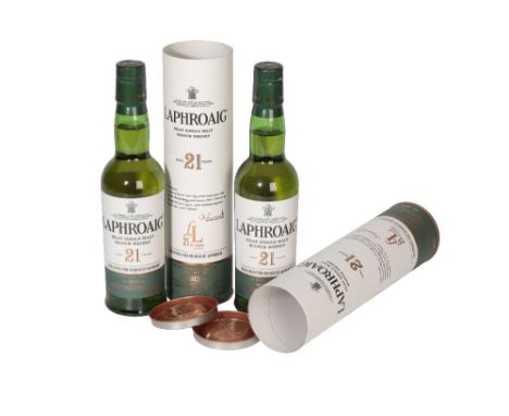
Lot 470
LAPHROAIG SINGLE MALT SCOTCH WHISKY, AGED 21 YEARS, limited edition release to celebrate the 21st anniversary of the Friends of Laphroaig, Isle of Islay, 35cl, 45.4% abv, in carton, 2 btls On the far edge of the Scotch whisky map, it's supposed that the art of distillation was first brought to Islay by Irish monks. Being remote, it's an art that flourished in the hands of the islanders, whose illegal operations tested the resolve and means of the tax man. Eventually, the law relaxed, various whisky makers set up legitimate distilleries, among them a pair of farmers, Donald and Alexander Johnston, who in 1815 founded their distillery on the island's south coast. Laphroaig, so called after its location, 'broad hollow by the bay.' It would remain in family hands for the next 139 years. Distilled in 1993, the year before the Friends of Laphroaig was founded, this whisky was maturing whilst the ranks of afficionados swelled to over 650,000 when bottled in 2015
-
109182 item(s)/page