We found 109182 price guide item(s) matching your search

Refine your search

Year

Filter by Price Range
  • List
  • Grid
  • 109182 item(s)
    /page

Lot 517

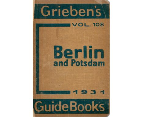
Grieben's Guide Books Volume 108 - Berlin Potsdam and environs. With information for motorists. 7th edition with 9 maps and ground plans. Published by Geographia Ltd. London. Grieben Verlag, Albert Goldsmith. Berlin. 1931. Contains 9 maps including large folding map of Berlin and also maps of roads, railways and suburbs of Berlin, and ground plans of buildings. 168 pages including index. A number of advertisements at front and rear. Publisher's printed boards. Rear cover detached. Interesting item for Berlin and Potsdam eight years before WW2. 1931. We combine shipping on all lots. Single book £5.99 UK, £7.99 Europe, £9.99 ROW. We can ship a parcel up to 20kg which will take approx. 40 books in UK £12, EUROPE £39.99, ROW, £59.99

Lot 522

Captain Spencer Author of Travels in Circassia - Turkey, Russia, The Black Sea and Circassia. Third thousand. Published by George Routledge and Co. London. 1854. Publisher's blue boards decorated and titled in gilt. An interesting work of 27 wood engravings. This work unfortunately lacks map stated on title page. 410 pages. RARE IN ANY CONDITIION. Lacks near free end paper. Base of spine slightly defective. Generally a clean, tight copy. 1854. We combine shipping on all lots. Single book £5.99 UK, £7.99 Europe, £9.99 ROW. We can ship a parcel up to 20kg which will take approx. 40 books in UK £12, EUROPE £39.99, ROW, £59.99

Lot 546

Philip Henry Gosse The ancient and modern History of the Rivers of the Bible. 2nd edition with a map. Published by G. Cox. London. 1850. 360 pages. All edges gilt. Very good copy, publisher's green boards, decorated in gilt and blind, titled in gilt. RARE. 2nd edition 1850. We combine shipping on all lots. Single book £5.99 UK, £7.99 Europe, £9.99 ROW. We can ship a parcel up to 20kg which will take approx. 40 books in UK £12, EUROPE £39.99, ROW, £59.99

Lot 551

Fred Burnaby A Ride To Khiva. Travels and adventures in Central Asia. With maps and an appendix. Containing a series of route marches. Translated from several Russian works. 12th edition. Published by Cassell, Petter and Galpin. London, Paris, New York. 1877. 487 pages. Folding map of Russia and China 25 x 10. Contained in wallet at rear of volume. Folding map as frontispiece of this work. Publisher's red boards, decorated and titled in black and gilt. 1877. We combine shipping on all lots. Single book £5.99 UK, £7.99 Europe, £9.99 ROW. We can ship a parcel up to 20kg which will take approx. 40 books in UK £12, EUROPE £39.99, ROW, £59.99

Lot 554

Jesse Lyman Hurlbut D. D. Travelling In The Holy Land Through a Stereoscope. A tour by Jesse Lyman Hurlbut. Published by Underwood and Underwood. London, New York. 1900. 195 pages. Publisher's green boards, decorated and titled in black and gilt. Folding map at rear of this work 10 x 18. This work contains other maps within the text. Very good condition. 1st edition 1900. We combine shipping on all lots. Single book £5.99 UK, £7.99 Europe, £9.99 ROW. We can ship a parcel up to 20kg which will take approx. 40 books in UK £12, EUROPE £39.99, ROW, £59.99

Lot 563

Patrick M. Synge Mountains of the Moon. An expedition to the Equatorial Mountains of Africa. Published by Lindsay Drummond Ltd. London 1937. 221 pages including index. A magnificent copy in quarter leather binding in very fine condition with a folding map at rear. Illustrated with photographs. Marbled boards, decorated and titled in gilt. 1st edition 1937. We combine shipping on all lots. Single book £5.99 UK, £7.99 Europe, £9.99 ROW. We can ship a parcel up to 20kg which will take approx. 40 books in UK £12, EUROPE £39.99, ROW, £59.99

Lot 572

Rev William Taylor California Life Illustrated Sixteen engravings. New edition revised and corrected, completing an issue of 31,000. Published by Jackson, Watford and Hodder. London. 1861. 391 pages. Agreed value of this volume resides in the map at the rear of the book of the Union Pacific Railroad and its connections. Map size 16 x 7½. Publisher's brown boards, decorated in blind, titled in gilt, lacks rear boards. RARE. 1st English edition 1861. We combine shipping on all lots. Single book £5.99 UK, £7.99 Europe, £9.99 ROW. We can ship a parcel up to 20kg which will take approx. 40 books in UK £12, EUROPE £39.99, ROW, £59.99

Lot 586

W. MacGillivray A. M. , F. R. S. E. The Travels and Researches of Alexander Von Humboldt. A condensed narrative of his journeys in the equatorial regions of America and in Asiatic Russia. With a portrait of Humboldt by Horsburgh. A map of Orinoco by Bruce and 5 engravings by Jackson. 3rd edition, revised. Published b Oliver and Boyd. Edinburgh and Simpkin Marshall. London. 1836. 428 pages including index. 16 additional of advertisements. Publisher's brown boards, decorated and titled in gilt. Spine defective. 1836. We combine shipping on all lots. Single book £5.99 UK, £7.99 Europe, £9.99 ROW. We can ship a parcel up to 20kg which will take approx. 40 books in UK £12, EUROPE £39.99, ROW, £59.99

Lot 595

Weighells Guide to Bude. With map and illustrations. Price threepence. Edward and Sons. Small booklet containing details of Bude. Approximately 40 pages with many traders' advertisements. published by Walter Weighell, printer and publishers. 1900. Publisher's card cover. Excellent condition, now RARE. 1900. We combine shipping on all lots. Single book £5.99 UK, £7.99 Europe, £9.99 ROW. We can ship a parcel up to 20kg which will take approx. 40 books in UK £12, EUROPE £39.99, ROW, £59.99

Lot 596

A folded linen map. Chelmsford, Maldon, Ingatestone and Hockley. Approximately 18 x 13, contained in a wallet of publisher's faded boards, titled in gilt. Circa 1890? Circa 1890?. We combine shipping on all lots. Single book £5.99 UK, £7.99 Europe, £9.99 ROW. We can ship a parcel up to 20kg which will take approx. 40 books in UK £12, EUROPE £39.99, ROW, £59.99

Lot 599

Linen map. Liverpool Bay 1967. Approximately 41 x 34 . Surveyed by the Marine Surveyor of the Mersey Docks and Harbour Board. Contained in attached, smart black boards, titled in gilt. RARE. Linen map. 1967. We combine shipping on all lots. Single book £5.99 UK, £7.99 Europe, £9.99 ROW. We can ship a parcel up to 20kg which will take approx. 40 books in UK £12, EUROPE £39.99, ROW, £59.99

Lot 600

National Grid Ordnance Survey Map No. 158. New popular edition. One inch map of England and Wales, Oxford and Newbury. Revision full 1935, Roads 1947 with later corrections. Folding map. Large cloth map, measuring 31 x 27. Contained in a wallet. Published by The Authority of the Ministry of Agriculture and Fisheries. 1947. We combine shipping on all lots. Single book £5.99 UK, £7.99 Europe, £9.99 ROW. We can ship a parcel up to 20kg which will take approx. 40 books in UK £12, EUROPE £39.99, ROW, £59.99

Lot 613

W. and A. K. Johnston Edinburgh and London. Popular map of Scotland. Showing roads and railways. On cloth in cloth case. Large, folding cloth map. Circa 1900 Circa 1900. We combine shipping on all lots. Single book £5.99 UK, £7.99 Europe, £9.99 ROW. We can ship a parcel up to 20kg which will take approx. 40 books in UK £12, EUROPE £39.99, ROW, £59.99

Lot 614

Map Ireland, Provinces and Counties. Scale 1 inch to = 12 miles. Issued by Bord Failte Irish Tourist Board. Printed by Hely Thom. Dublin. Large, folded map of Ireland on thick paper. Circa 1966. Circa 1966. We combine shipping on all lots. Single book £5.99 UK, £7.99 Europe, £9.99 ROW. We can ship a parcel up to 20kg which will take approx. 40 books in UK £12, EUROPE £39.99, ROW, £59.99

Lot 615

Ordnance Survey map of Southern Britain In the Iron Age. Scale 1:625,000. About ten miles to one inch. Made and published by the Director General of The Ordnance Survey. Chessington. Surrey. 1962. Reprinted 1967. Fine copy in fine D/W. 1967. We combine shipping on all lots. Single book £5.99 UK, £7.99 Europe, £9.99 ROW. We can ship a parcel up to 20kg which will take approx. 40 books in UK £12, EUROPE £39.99, ROW, £59.99

Lot 621

A rolled-up Ordnance Survey map of The Geological Survey of the Isle of Wight. Dated 1885. Printed for Ordnance Survey in 1926. Reprinted in colour with amendments in 1935. Reprinted again in 1947. Rolled map of approximately 29 x 21 in excellent condition. Now considered RARE. We combine shipping on all lots. Single book £5.99 UK, £7.99 Europe, £9.99 ROW. We can ship a parcel up to 20kg which will take approx. 40 books in UK £12, EUROPE £39.99, ROW, £59.99

Lot 622

Large folding map of Europe, contained in dark green boards, titled in gilt label. Published by Edward Stanford Ltd. Circa 1920? Cartographers to His Majesty the King. London 1920?. We combine shipping on all lots. Single book £5.99 UK, £7.99 Europe, £9.99 ROW. We can ship a parcel up to 20kg which will take approx. 40 books in UK £12, EUROPE £39.99, ROW, £59.99

Lot 632

Large, folded cloth map of Argentina. Published by Officina Cartogratice Ludwig Buenos-Aires. 1921. In publisher's grey board covers, titled in black. Nuevo mapa de los Ferrocarriles de la Republica Argentina. Excellent copy. RARE. 1921. We combine shipping on all lots. Single book £5.99 UK, £7.99 Europe, £9.99 ROW. We can ship a parcel up to 20kg which will take approx. 40 books in UK £12, EUROPE £39.99, ROW, £59.99

Lot 633

Small, folded map of British North Borneo. Area of the Chartered Company's Property estimated 31,000 square miles. Published by The British North Borneo Company. Incorporated by Royal Charter under the Great Seal 1st November 1881. Measuring 13 x 8½. Circa 1909. An interesting map of an unvisited area in early exploration. Circa 1909. We combine shipping on all lots. Single book £5.99 UK, £7.99 Europe, £9.99 ROW. We can ship a parcel up to 20kg which will take approx. 40 books in UK £12, EUROPE £39.99, ROW, £59.99

Lot 660

Reproduction coloured map 14½ by 11 of Blaeuw's World Atlas (French version) in the Württemberg Library, Stuttgart, Germany. Published in Amsterdam 1645. We combine shipping on all lots. Single book £5.99 UK, £7.99 Europe, £9.99 ROW. We can ship a parcel up to 20kg which will take approx. 40 books in UK £12, EUROPE £39.99, ROW, £59.99

Lot 79

St Clair Baddeley and Lina Duff Gordon Rome and its Story. Illustrated by Aubrey Waterfield. published by J. M. Dent and Co. London. Publisher's red boards. Decorated and titled in gilt. Excellent copy, including map. 1st edition 1904. We combine shipping on all lots. Single book £5.99 UK, £7.99 Europe, £9.99 ROW. We can ship a parcel up to 20kg which will take approx. 40 books in UK £12, EUROPE £39.99, ROW, £59.99

Lot 486A

COVENS, JEAN et MORTIER, CORNEILLEÊCARTE tres Commode aux GENS de GUERRE, INGENIEURS et CANNONIERSÊ A Dutch early-C18th map/diagram for the use of military engineers, architects and artillerymen, framed under glass. Visible printed area measures approx. 70.5cm x 51.5cm Condition Report:Available upon request

Lot 560

Ham radio: a considerable quantity of QSL radio operator's calling cards, together with a Radio Society of Great Britain Great Circle DX Map on board backing, measuring approx. 78cm x 63cm Condition Report:Available upon request

Lot 571

Two binocular microscopes, one cased, one boxed, together with a pair of leather-covered map weights by J. Halden & Co. Ltd, Manchester Condition Report:Available upon request

Lot 583

MAPS A quantity of maps, plans and prints pertaining to the city of Edinburgh and its environs (both facsimile and original), including a framed map titled a New Description of the Shyres Lothian and Linlithqvo by Timothy Pont, removed from a book, with bookplate of Mactie of Dreghorn included verso Condition Report:Available upon request

Lot 179

Various collectibles to include a limited edition Sinirli Uretim, Geleneksel Camlar traditional designed glass plate in presentation box, ten modern and vintage paper hand fans, a small engraved coloured map of the United Kingdom, framed, a small Chinese porcelain Famille Rose jug with cover and a set of four modern Chinese jade-style hand painted eggs and stands.Qty: 14

Lot 193

Various brass mostly maritime related items to include pocket brass telescopes, including one on a Chinese dragon stand, a map magnifier, desk magnifying glass on wooden stand, two opera glasses and two novelty kaleidoscopes.Qty: 10

Lot 163

After Valerie Ganz (Welsh 20th Century), Mumbles lighthouse and life boat station and moored sailing boats (probably Mumbles), both signed in the plate and additionally signed by the artist dated '76. 38 x 49cm approx. Together with a reproduction map of Glamorganshire. Framed. (B.P. 21% + VAT)

Lot 178

Framed hand drawn map of Llansamlet Pit. (B.P. 21% + VAT)

Lot 257

AMENDED DESCRIPTION - Collection of prints, some car-related, to include: a map of Surrey, frame size 63 x 82cm, Porsche 911 poster, frame size 98 x 66cm, a photo of Nigel Mansell, with various other miscellaneous prints, all framed. (10)PLEASE NOTE THAT THE LOT NO LONGER INCLUDES THE GRAVIER ETCHING

Lot 213

A ROLLS ROYCE MODEL TABLE LIGHTER, MAP, DRIVING LICENCE AND FIVE OFFICIAL ROLLS ROYCE BOOKS

Lot 2286

A SHABBY CHIC CHEST OF SIX DRAWERS, THE TOP DECORATED WITH A WORLD MAP

Lot 438

TWO SIGNED COLOURED PRINTS OF WORLD WAR II AIRCRAFT, SIGNED PRINT OF BATTLE OF BRITAIN A.C.E. WING COMMANDER GEOFFRY PAGE D.S.O. D.F.C., PRINTS OF AIRCRAFT AND A FOLDING MAP

Lot 1221

A VINTAGE SCROLL MAP OF 'THE LONDON MIDLAND AND SCOTTISH RAILWAY AND CONNECTIONS'

Lot 297

A chart of the Ethiopic or Southern Ocean and part of the Pacific Ocean from the parallel of 3 degrees N to 56 degrees 20' South Latitude drawn from the latest observations of the Spanish, Portuguese and Dutch astronomers by J. Foss Dessiou, Master of the Royal Navy, London, published by W. Faden, Geographer to His Highness the Prince of Wales, Charing Cross January 1st 1808, engraved map, framed, 59 x 89cm Please refer to department for condition report

Lot 298

Franklin, John, Journey to the Shores of the Polar Sea, In 1819-20-21-22: With a Brief Account of the Second Journey In 1825-26-27, 4 Vols., with fold-out map, half leather with marbled boards, gilt lettering to spines, London: John Murray, 1829; together with other bindings, comprising: Quintus Horatius, Flaccus, full leather, decorative gilt spine, 1713; The Works of Virgil, Translated by John Dryden, half leather with marbled boards, London: Printed for T. and J. Allman, 1823; Oliver Goldsmith, Essays, Poems & Plays, full leather, gilt, London: Printed for F. C. & I. Rivington 1821; and Madame de Maintenon, Esprit de Mmes de Sevigne et de Maintenon, 2 Vols., full leather, gilt, Paris: Saintin, Libraire de la Cour, 1819 (9)Please refer to department for condition report

Lot 837

A FRAMED MAP OF SOUTH AMERICA 87CM X 68CM

Lot 865

A MIXED LOT TO INCLUDE AN ALBUM OF POSTCARDS, TEA CARDS, STAMPS, A VINTAGE MAP AND A BOXED PLATIGNUM PEN

Lot 430

Quantity of framed and glazed prints to include Two Russell Flint Prints, floral Joseph Nigg, military prints, map of Scotland, etc

Lot 222

ORIGINAL PRESS PHOTOGRAPH 17/2/92 MAP SHOWING THE RUC STATION WHERE THE TERRORISTS OPENED FIRE LAST NIGHT BEFORE THEY WERE SHOT DEAD

Lot 116

After BENJAMIN DONNE (1729-1798). A pair of engraved maps: “A Plan of Bristol, Clifton, The Hotwells, etc. from An Actual Survey by B. Donne”, with numbered key of landmarks, etc., originally published 1826; facsimile by Messrs Waterlow & Sons Limited 1966; in matching glazed frames, each 21½” x 30­½” over-all; Together with a reprinted map of “Somersetensen” after Saxton, in glazed frame, 16½” x 21¼”

Lot 145

JOHN SPEED hand coloured engraved map - Wales with English text verso, the general description and several divisions of the principality of Wales, to be sold by John Sudbury and George Humble in Pope's Head Alley 1610, 38 x 50cms

Lot 146

EMMANUEL BOWEN circa 1740 - black and white engraved map, 'An Accurate Map of North Wales Divided Into It's Counties', 56.5 x 74.5cms, and ROBERT MORDEN circa 1722 - black and white engraved map of Denbighshire, 16.5 x 21cms

Lot 126

Important collection of militaria belonging to Robert Wellesley Smith, Royal Marines during WW11 II to include bar with 5 medals – 1939 -1945 medal, The Defence medal, 1939-1945 Star, France and Germany Star and the Burma Star, 2 Royal Marines Commando patches, 2 RM cap badges, 2 Royal Marines round patches, ribbon bar, Certificate of Service, ID Card, photograph of Robert Smith, Tracings for Route for Ferry Craft which had been cleared of mines and marking safe passage from Plymouth to France, map of English Channel Eastbourne to Poole, cloth map of Siam (Thailand) (Part of) Sumatra (North) sheet E, leaflet from Supreme Headquarters Allied Expeditionary Force signed by Dwight Eisenhower, Japanese paper fan, silk souvenir postcard 1940 France, boxed Japanese writing set, boxed wooden chopsticks, Japanese flag and pennant, reproduction  D-Day newspaper from The Times, June 7th, 1944 all in original military wooden crate. Family have given story of his wartime experiences. PLEASE NOTE His SOE Escape Knife and Signed Tang offered in the the next lot

Lot 282

A hand coloured engraved map of Northumberland, 25cm by 32cm, together with a further map of Nottinghamshire and a map of Derbyshire.

Lot 442

An 18th century hand coloured map of Northumberland, London engraved for J. Harrison, 35cm by 49cm.

Lot 447

CRESTED WARE; a group of various pieces of crested wear including Goss and Arcadian, map of Isle of Wight, lifeboat memorial, Stonehenge', etc.

Lot 253

A map of India, published principally for the use of the Officers of the Army in India, inscribed ‘London 1825 drawn & engraved by John Walker’ and ‘ Published as the Act directs by Kingsburg, Purbury & Allen. Leadenhall Street. London Jan 11th 1825’, contained within a hardbound folder, 153 x 126cmCondition ReportCreasing to map, cloth bound, losses to marbled cover and wear to edges. Dated 1825. Please see the additional images.

Lot 258A

A Facsimile Map of the County of Essex, from an actual Survey taken in MDCCLXXl, LXXlll and LXXlV by John Chapman and Peter Andre, in book form,55.5 x 38.5cm

Lot 347

'Italy From The Original Map by G.A. Rizzi-Zannoni, engraved for The Classical Tour Through Italy by The Revd J.C. Eustace',published London 1814 by J Mawman, hand-coloured,97 x 40cmCondition ReportWith folds

Lot 1018

Robert Morden, framed antique hand coloured map of Dorset, together with a rosewood framed reproduction map of Surrey, after Moll

Lot 1045

Antique hand coloured map of Somerset, double glazed, 38cms x 50cms, another hand coloured framed map ' The Road to Exeter ', another map of Somerset, map of Shropshire and a hand coloured hunting engraving after Alken

Lot 1046

Folio containing a quantity of various antique maps and engravings, mainly Somersetshire including an uncoloured map by Robert Morden, another by Bowen, among many others etc.

Lot 1137

Antique hand coloured map of Lincolniae (lower margins trimmed) gilt framed, 31cms x 36cms

Lot 1163

19th Century map of the County of Surrey, published July 4th 1829, 57cms x 68cms, a large framed hand coloured map of the county Palatine of Lancaster, 70cms x 56cms, and another hand coloured map of the county Palatine of Lancaster, 65cms x 70cms

Lot 1224A

Antique hand coloured map of the West Riding of Yorkshire by Robert Morden, 36cms x 41cms approximately, in a modern burr wood frame

Lot 967

Large antique hand coloured map of the city of Hereford by J. Taylor, 67cms x 89cms, in an ebonised and gilt frame

Lot 1259

Framed antique hand coloured map of Albion and Hibernia, 37.5cms x 44.5cms

Lot 1269

Antique hand coloured map of Surrey, framed, 42cms x 52cms

Lot 1552

Reproduction mahogany and brass rectangular coffee table, the glass top inset with a reproduction World map, 89cms x 61cms

Loading...Loading...
  • 109182 item(s)
    /page

Recently Viewed Lots