We found 109182 price guide item(s) matching your search
There are 109182 lots that match your search criteria. Subscribe now to get instant access to the full price guide service.
Click here to subscribe- List
- Grid
-
109182 item(s)/page


Lot 458
Irene Lesley Maine,The Church of St Mary's Turville,signed, watercolour, dated 1984,18 x 26cm,The Vicar of Dibley featuing Dawn French was filmed in Turvile Church.An antiquarian map of Market Harborough, titled " A Plan of Town of Market Harborough by Samuel Turner and Rowland Rouse" a later copy re-painted in watercolours.


Lot 520
Benard, Carte de la Cote N.O. de M'Amerique ... 1778-79, a folding map; another Carte Generale Offrant Les Decouvertes Faites Pas Le Captaine Jacque Cook; together with other maps and plans, including some reproductions.Condition report:Please see additional uploaded images of all the other maps in this lot, including the reproductions.

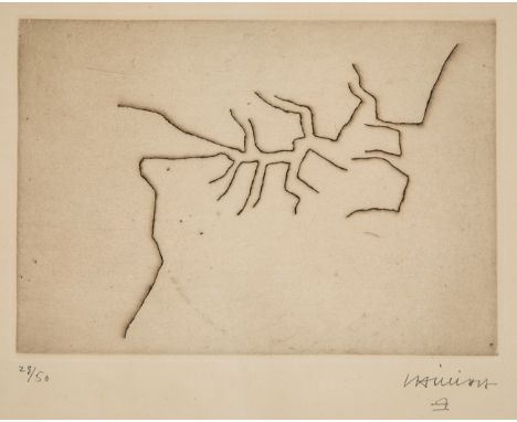
Lot 16
EDUARDO CHILLIDA JUANTEGUI (San Sebastian, 1924 - 2002)."Articulation".Etching on Rives BFK paper. Copy 28/50.Work reproduced in OPUS Volume I, page 52, Nº 62001.Signed and justified in pencil.Measurements: 15.5 x 20.7 cm (print); 38 x 48 cm (paper); 39 x 49 cm (frame).The idea of articulation was a constant in the work of Chillida, who reflected the concept through painting and sculpture. In this particular case, the work on paper shows us a set of vibrant lines that seem to simulate a map in which the spectator can lose himself by looking through the lines.Chillida began his training at the School of Architecture at the University of Madrid, but abandoned his studies to devote himself to football, as goalkeeper for Real Sociedad. As a result of an injury he was forced to give up sport, and it was then that his artistic vocation awoke. He began drawing at the Círculo de Bellas Artes in Madrid, and little by little his interest in sculpture grew. It was during his years in Paris that he made his first plaster sculptures, impressed by the archaic Greek sculpture in the Louvre. He held his first sculpture exhibition in the French capital in 1950. It was at this time that he began his rivalry with the sculptor Jorge Oteiza, who accused him of plagiarising his work. Both with a work linked to the constructivist tradition, they nevertheless dealt with different themes. In 1951 he returned to San Sebastián for good, and produced his first work in iron, the material he would work with for the rest of his life. With the idea that art should be accessible to everyone, he produced numerous public works throughout his life, as well as sculptures for museums all over the world. His works dialogue with their surroundings, which is why many of them are already considered emblematic places for citizens, as is the case with the "Peine del viento" in San Sebastian and the "Puerta de la Libertad" in Barcelona. Throughout his life, Chillida received numerous prizes and awards, including the Carnegie Prize (1965), the Rembrandt Prize (1975), the Wolf Foundation Prize for the Arts (1984/85) and the Prince of Asturias Prize for the Arts (1987). He was also a member of the Royal Academy of Fine Arts of San Fernando, a member of the American Academy of Arts and Sciences, an Honorary Member of the Royal Academy of Arts in London, a member of the Imperial Order of Japan, and was awarded the Grand Cross for Humanitarian Merit by the Institution of the same name in Barcelona. In addition to his Chillida-Leku Museum in Hernani, he is represented in museums and collections all over the world, such as the Guggenheim in Bilbao, the MOMA in New York, the Reina Sofía in Madrid, the Tate Gallery in London and the Neue Nationalgalerie in Berlin.


Lot 144
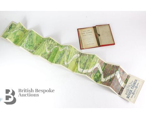
Bird's Eye View of the Thames London to Oxford - In three sections plus accompanying 46 page booklet. Each section has 14 panel linen fold-out maps in lovely, clean condition, very attractive. In worn red gilt covers, no date but on the last map Tower Bridge is captioned as 'constructing', building work completed circa 1886-94 so maps are circa 1890.


Lot 154
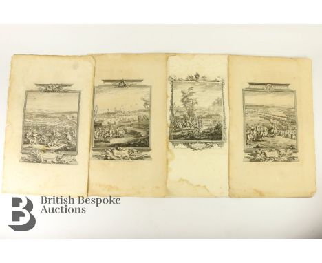
Tindall Nicolas Rev - History of England pages and maps, 18th century, including Map of the Seat of War in Hungary between the Imperialists and the Turks; Map of the Seat of War in Germany; Map of the Seat of War in Italy. The lot continues with maps of cities, battle sites including Plan of Mons; Plan of the Camp & Retrenchments of Denain; Camp of the Army of the Allies Commander by General Auverquerque; Arras the Capital Town of the County of Artois; Plan of Oudenard a Fortified Town in the Earldom of Flanders; Plan of Dunkirk as given to the Duke of Ormond when he left the Army of Allies 1712; Plan of Lisle besieged and taken by the Allies in 1708; Plan of the Battle fought near Winendael; Plan of the City and Citadel of Turin; Lines of Stolhoffen in Alsacia; Battle of Donawert July 1704; Plan of Temiswar and it's Neighbourhood; Plan of Bethune Artois; Plan of Tournay 1709; Plan of the Battle of Eckeren 1703; Plan of Ausburg & Adjacent Country; Old and New Brisach; Plan of the Town of Barcelona; Plan of the Town and Castle of Traarbach; Plan of the Battle of Marseille; Plan of the Town of Menin; Plan of Ypres; Plan of Philipsbourg; Plan of the Town of Bouchain; Plan of the Battle of Chiari; Plan of the Battle of Quesnoy; Plan and Attack of the Town of St Leeuw. Lastly this lot contains title pages including 'The Passage of Scbeld', 'Duke of Marlborough and Prince Eugene of Savoy entering ye enemys intrenchments at the Battle of Taniers; Siege of Mons and The Battle of Luzzara.


![JOHN SPEED: NORFOLK A COUNTIE FLORISHING & POPULOUS DESCRIBED AND DEVIDED..., engraved map [1623], approx 370 x 490 mm, d](https://cdn.globalauctionplatform.com/ea8d4e51-1427-438a-a5b3-af660105b8d5/a6c42b45-0d8f-49b4-8133-af6b00f63e32/468x382.jpg)
![ROBERT MORDEN: NORFOLK, engraved part hand coloured map [1695], approx 370 x 580 mm, framed and glazed](https://cdn.globalauctionplatform.com/ea8d4e51-1427-438a-a5b3-af660105b8d5/7eeddb95-29f3-4b77-b98b-af6b00f64332/468x382.jpg)
![CHRISTOPHER SAXTON/WILLIAM KIP: NORFOLCIAE COMITATUS... engraved hand coloured map [1637], approx 270 x 380 mm, framed and gl](https://cdn.globalauctionplatform.com/ea8d4e51-1427-438a-a5b3-af660105b8d5/6b8d5de4-b238-4895-8876-af6b00f64cbd/468x382.jpg)


Lot 107
Rowling, J. K. Harry Potter and the Philosopher's Stone, 15th Anniversary Edition published exclusively for 15 competition winners [not released for sale], signed & dedicated by the author, London: Bloomsbury, [2012]. Octavo, full red crushed morocco, all edges gilt. Together with the original entry that successfully secured this book in Bloomsbury's competition. In 2012, Bloomsbury launched a nationwide competition to find the UK's 'biggest Harry Potter fan'. Fans were invited to write a letter of no more than 50 words explaining why they love Harry Potter and were encouraged to draw, doodle and make their letters as elaborate as possible. Fans could only enter by submitting their letters through specially-designed postboxes at participating bookshops and libraries. The winner of the competition received one of these exclusive books and a family holiday to The Wizarding World of Harry Potter at Universal Orlando Resort. The 14 runners-up each received one of these exclusive books. The entry included in this lot is an exquisitely designed and decorated letter in the form of a folding document, which was inspired by the magical Marauder's Map, successfully securing a runners-up prize. The book has been treasured and kept safe, and is therefore in fine, unread conditionProvenance: Vendor was one of the 14 runners-up of Bloomsbury's competition to find the UK's "biggest Harry Potter fan". The artwork included in this lot is her original successful entry

Lot 139
Smith, C. New Map of the Country Twelve Miles Round London, 1823, hand-coloured copper engraving, sectional, linen-backed, approx. 75cm by 85cm, housed in publisher's card slipcase bearing the original engraved label. The map is very good and well-preserved, the slipcase has wear to corners & edges

Lot 140
Map of London with the Latest Improvements, London: J. Reynolds, 1848. Hand-coloured engraving, sectional, linen-backed, within publisher's contemporary ribbed-cloth boards lettered in gilt, 'Map and Strangers Guide Through London'. The map itself is well-preserved with splitting to some of the sectional fold-lines (not affecting the engraved detail); the publisher's upper board & text pages detached. Together with an 18th-century plan of London by Emanuel Bowen, mounted on heavy paper; Post Office Principal Streets and Places in London, 1857, boards detached; The London Street Guide, Geographia, n.d., worn/loose covers, and a small quantity of later maps & books to include Aerbut Paerks of Baernegum: Six Dialect Monologues, by Graham Squiers, Birmingham: Cornish Brothers, 1923, collection sold with all faults
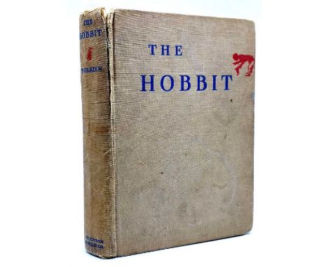
Lot 19
Tolkien, J. R. R. The Hobbit, first American edition, second state [publisher's logo on title, 'Chapter VI instead of VII on p. 118], Boston & New York: Houghton Mifflin Company, 1938. Octavo, publisher's cloth, map endpapers, half-title, colour frontispiece, 310pp., lacking colour plate to face p. 118, all other plates present as called for, contents generally clean & bright, occasional creasing & tears including to some of the plates, one plate detached, cloth with general discolouration and splitting to joints, wear to corners, sold with all faults
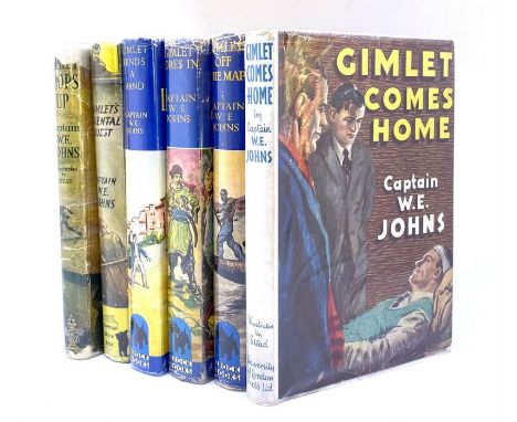
Lot 31
Johns, W. E. Gimlet Comes Home, first edition, Hodder & Stoughton, 1946, illustrated by W. Stead, unclipped dust-jacket, neat owner inscription. Tog. w/ five Brockhampton first editions comprising: Gimlet's Oriental Quest, 1948, unclipped d.j.; Gimlet Lends a Hand, 1949, clipped d.j.; Gimlet Bores In, 1950, unclipped d.j.; Gimlet Off the Map, 1951, unclipped d.j.; Gimlet Mops Up, first edition, 1947, the final title in worn wrapper with loss & lacking ffep (6)

Lot 35
Johns, W. E. Biggles Sweeps the Desert, first edition, October 1942, colour frontis. & eight b&w illustrations (two double-page), restored wrapper; Biggles Fails to Return, first edition, August 1943, colour frontis. & 15 illustrations, map endpapers, dust-jacket with loss at top & bottom of spine; Biggles in the Jungle, first edition, 1944, colour frontis. & four illustrations by Terence Cuneo, dust-jacket chipped at edges, loss at base of spine, cloth faded top & bottom edges; Biggles in the Orient, first edition, November 1944, colour frontis. & 12 illustrations by W. Stead, dust-jacket priced 6/- on flap, pale blue cloth, slightly faded at spine & corners (4)
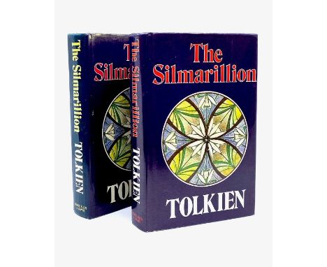
Lot 42A
Tolkien, J. R. R. The Silmarillion, edited by Christopher Tolkien, first edition, London: George Allen & Unwin, 1977. Octavo, publisher's navy cloth lettered in gilt, unclipped dust-jacket. Contents very good, clean, bright, a couple of light handling marks to endpapers, a few small spots to fore-edge, binding very good, tight & square, cloth very well-preserved, dust-jacket very good, bold & bright, folding map at rear well-preserved. Together with another the same in clipped d.j. with faded spine (2)

Lot 6
Chauncy, Sir Henry. The Historical Antiquities of Hertfordshire, in two volumes, Bishops Stortford: J. M. Mullinger, 1826. Large octavo, quarter buckram with paper-covered boards and paper title labels, illustrated with numerous lithographic plates and a large folding map. Contents appear generally good but with spotting, not collated, sold with all faults (2)
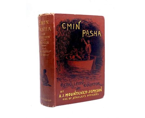
Lot 80
Mounteney-Jephson, A. J. Emin Pasha and the Rebellion at the Equator, third edition, presentation copy inscribed by the author, London: Sampson Low, 1890. 'F Brodie Lodge, from the author, Sep 1898', followed by an explanatory note by the recipient, 'Given to me at Carqueiranne where we were both staying that summer of 1898. Major Jephson took me about with him there often. (He, a charming kindly Irishman, I, a boy of eighteen). F. Brodie Lodge', plus ownership stamp of the same. There is a pasted newspaper clipping recording Mounteney Jephson's death on the facing page. Octavo, publisher's pictorial gilt cloth, xxiv, 490pp., 2pp. publisher's advertisements for African Literature, frontispiece portrait of the author, numerous wood-engraved illustrations throughout, folding map, and folding Copy of the Mahdi's Letter. Contents good & bright, some pale spotting in places, cloth binding with some bumping & wear around corners & edges but otherwise goodArthur Jermy Mounteney Jephson (1859-1908) was an adventurer who accompanied H. M. Stanley on the Emin Pasha Relief Expedition, 1887–1889

Lot 83
Thomson, John. A New General Atlas of the World, Edinburgh: Printed by John Stark, 1830. Large quarto (56cm by 46cm), worn half-calf, [xxiv], 101 double-page, hand-coloured, copper-engraved maps. Almost all of the maps are very well-preserved & bright, a few have some marks and short tears to the wide margins, there is an original publishing crease through the right-hand margin of some maps, the map of the Southern Part of England is detached & worn at edges of margins, binding worn


Lot 1081
After Philips Wouwerman (1619-1668)''Les Sangliers Forces''Black and white engraving; together with a map of Leicester, two black and white prints, a print of Lancaster castle, a print of the resurrection , a landscape watercolour, a Russian watercolour of St Issac's catherdral and a painted panel river landscape inlaid with mother of pearl (9)

Lot 121
China - - Frank Dorn. A Map and History of Peiping. With Explanatory Booklet. Sowie: The Map of Peiping with Street Directory (Alphabetical and Numerical). Mit mehrfach gefalteter chromolithogr. Karte von Peiping (Peking). Tientsin-Peiping, The Peiyang Press, 1932 bzw. 1936. (I) 1 Bl. 22 S. (II) 20 S. Kl.-8°. OHLwd d. Zeit mit Einstecklasche und OKt. (im Rand etw. knickspurig u. mit kl. Einrissen). Der mehrfach gefaltete und chromolithographische Stadtplan (ca. 61 x 50 cm) von 1932 hier als Einlage im Reiseführer von Frank Dorn aus dem Jahr 1936. In dieser wohl originalen Zusammenstellung sehr seltene Publikation. Diese Broschüre und Karte war ursprünglich eine Ergänzung zu dem "Peiping Shopping Guide". Mit alphabetischen Register der Straßen in romanisierter Schreibweise sowie chinesischer Schrift. - Die erläuternde Broschüre Frank Dorns umschreibt in kurzer Zusammenfassung die Geschichte der Stadt, listet die versch. Dynastien Chinas seit ca. 3000 v. Chr. auf und geht schließlich auf einzelne Sehenswürdigkeiten der auf der Karte genannten Orte mit kurzen Beschreibungen ein. - Papierbedingt zart u. gleichmäßig gebräunt, wenige Bll. etwas stärker, mehrere Bll. betreffende punktuelle Druckstelle, im Randbereich tls. etw. knickspurig. Der Plan von Peking bis auf wenige kleine Stockflecken im Rand u. kl. Einriss in der Falz in sehr schönem Zustand, die Farben kräftig erhalten. With multiple folded chromolithographic map of Peiping (Beijing). Contemporary half cloth with flap and original cardboard binding (in the margins somewhat creased and with small tears). - The multi-folded and chromolithographic city map (ca. 61 x 50 cm) from 1932 here as an insert in the travel guide by Frank Dorn from 1936. In this probably original compilation very rare publication. This brochure and map was originally a supplement to the "Peiping Shopping Guide". With alphabetical index of the streets in romanized form as well as Chinese characters. - The explanatory brochure by Frank Dorns briefly describes the history of the city, lists the different dynasties of China since ca. 3000 B.C. and gives short descriptions of individual sights of the places mentioned on the map. - Paper conditionally lightly and evenly browned, a few p. somewhat stronger, several p. concerning punctual pressure mark, in the marginal area partly somewhat creased. The map of Peking in very fine condition, except for a few small foxing spots in the margin and a small tear in the fold, the colours well preserved.
Lot 305
François de Salignac de La Mothe Fénelon. Les Avantures de Télémaque, fils d'Ulysse. Par feu Messire François de Salignac, De la Mothe Fénelon, Précepteur de Messeigneurs les Enfans de France, & depuis Archevêque-Duc de Cambray, Prince du Saint Empire. Nouvelle Édition, Conforme au Manuscrit original, Et enrichie de Figures en taille-douce. Mit gest. Frontispiz, gest. Porträt, gest. Karte, 24 Kupfertafeln sowie zahlreichen Vignetten. Amsterdam, J. Wetstein und G. Smith, Rotterdam, J. Hofhout, 1734. 2 Bll., X, XXVII (recte XVII), 424 S. 4°. Geflecktes Kalbsleder d. Zt. auf 5 Bünden mit reicher verg. RVerzierung und RSchild. Steh- und Innenkantenfileten, Marmorvorsätze, Rotschnitt. (Etwas berieben und bestoßen, Gelenke angeplatzt, oberes Kapital mit Fehlstelle) Brunet II, 1214. Fürstenberg 71. Sander 657. Cohen-R. 381. - Wunderbar illustrierte Ausgabe dieses Meisterwerks des 18. Jahrhunderts, einschließlich der drei oft fehlenden Blätter der Ode am Ende und der Kupferstichkarte "Carte des voyages de Télémaque selon Mons.r Fénelon par le S.r Rousset". Die Tafeln gestochen u.a. von Folkema nach Dubourg und Picart und Gunst nach Debrie. Das Porträt des Autors von Drevet nach Vivien. - Papierbedingt gebräunt und vereinzelt etwas fleckig. 1 Bl. im unteren Rand hinterlegt. Insgesamt wohlerhalten. With engr. frontispiece, engr. portrait, engr. map, 24 copper plates and numerous vignettes. Cont. mottled calf with rich gilt ornamentation and label on spine. (Somewhat rubbed and bumped, joints chipped, upper capital with missing part). - Wonderfully illustrated edition of this 18th century masterpiece, including the three often missing leaves of the ode at the end and the engraved map "Carte des voyages de Télémaque selon Mons.r Fénelon par le S.r Rousset". The plates engraved by Folkema after Dubourg and Picart and Gunst after Debrie, among others. The portrait of the author by Drevet after Vivien. - Paper browned and a little bit stained in places. 1 sheet backed in lower margin. Altogether in good condition.

Lot 148
Marokko - - James Grey Jackson. An Account of the Empire of Marocco, and the District of Suse. Compiled from Miscellaneous Observations Made During a Long Residence in, and Various Journeys Through, those Countries, to Which is Added an Account of Timpuctoo, the Great Emporium of Central Africa. Mit 11 (2 koloriert, 5 gefalt.) Aquatintatafeln und 2 gefalt. Kupferstichkarten. London, W. Bulmer, 1809. xvi, 287 S. 4°. Mod. Lwd. mit goldgepr. schwarzem RSchild. Abbey 296. - Gay 1248. - Henze II, 696. - Graesse III, 441. - Vgl. Brunet III, 477 (3. Ausgabe). - Umfangreiche Reisebeschreibung über das Königreich Marokko. Behandelt wird die Geographie, die Flüsse, Klima, Berge, Kultur, Wirtschaft, Zoologie (insbesondere Schlangen), Metallurgie, Mineralogie, Bevölkerung, der Islam und die Sprachen, sowie die Pandemie 1799/1800. - "Jackson lebte sechzehn Jahre in verschiedenen Teilen Marokkos, wo er emsig Nachrichten über dieses Land wie auch über das Innere Nord-Afrikas, u.a. über Handel und Handelsstraßen nach Timbuktu und diese Stadt selbst, einzog" (Henze). - Eine Karte mit kleinen Defekten, nur seltener minimal fleckig bzw. gebräunt. Gutes Exemplar. Arabia - Northafrica - Morocco - With 11 (2 coloured, 5 folded) aquatint plates and 2 folded copper engraved maps. Mod. cloth with gilt stamped black spine labels. - Extensive travel description of the Kingdom of Morocco. Covers geography, rivers, climate, mountains, culture, economy, zoology (especially snakes), metallurgy, mineralogy, population, Islam and languages, as well as the pandemic of 1799/1800. - "Jackson lived for sixteen years in various parts of Morocco, where he assiduously gathered news about that country as well as about the interior of North Africa, including trade and trade routes to Timbuktu and that city itself" (Henze). - One map with small defects, only rarely minimally spotted, resp. browned. Good copy.

Lot 158
Südost-Asien - Indonesien - Philippinen - - Thomas Forrest. Voyage aux Moluques et a la Nouvelle Guinée, fait sur la galere La Tartare en 1774, 1775 & 1776 par ordre de la Compagnie Angloise. Mit 1 gefalt. Kupferkarte u. 27 teils gefalt. Kupfertafeln. Paris, Hôtel de Thou, 1780. 3 Bll., 470 S., 1 Bl. 4°. Ldr. d. Zt. mit RSchild u. reicher RVerg. (nur minimal berieben). Erste franz. Ausgabe. - Graesse II, 616. - Henze II, 261. - vgl. Eutiner Landesbibl. I, 436 (engl. Ausgabe): "Kapitän Forrest erkundete im Dienst der Englisch-Ostindischen Compagnie in den Jahren 1774-76 zahlreiche indonesische und philippinische Inseln. Er war 1770 beauftragt worden, auf Balambangan neue Kolonien anzulegen. Die mehr als zweijährige Reise führte in einem winzigen Schiff durch die südostasiatischen Küstengewässer. Forrests Bericht zeichnet u.a. auch die Entdeckungsgeschichte Ostindiens und die konkurrierenden europäischen Handelsinteressen nach." - "Sein 1779 erschienenes Reisewerk brachte vielerlei Neues über den O Insulindes ... und besondere Bedeutung kommt ihm zu als 'Erstem genauen Beobachter von Neu-Guinea'" (Henze). - Mit dem häufig fehlenden "Vocabulaire des la langue Magindano". - Die Tafeln mit Karten, Ansichten und völkerkundlichen Darstellungen. - Etwas gebräunt bzw. etwas fleckig, bis etwa S. 40 stärker, die Tafeln etwas gebräunt bzw. braunfleckig, sonst meistens wohlerhalten. Southeast Asia - South Seas - Moluccas - New Guinea. - First French edition. - Contains the often missing "Vocabulaire des la Langue Magindano". - With 1 folded copper engraving map and 27 (some folded) copper engraving plates. - Contemp. calf, label and gilt to spine (minimally rubbed). - "Captain Forrest explored numerous Indonesian and Philippine islands in the service of the English East India Company in 1774-76. In 1770 he was commissioned to establish new colonies on Balambangan. The voyage, which lasted more than two years, took him in a tiny ship through the coastal waters of Southeast Asia. Forrest's report also traces, among other things, the history of the discovery of East India and the competing European trade interests". - His travelogue, published in 1779, brought many new facts about the O Insulindes ... and he is of special importance as the 'first precise observer of New Guinea'". (Henze). The plates with maps, views and ethnographic illustrations. - Somewhat browned and somewhat stained, heavier up to about p. 40, the plates somewhat browned resp. brown-stained, otherwise mostly in good condition.

Lot 116
Giovanni Botero. Allgemeine Historische Weltbeschreibung ... in vier Bücher abgetheilt: Im ersten wirdt Europa, Asia, Affrica, vnd die Sitten ..., im andern wirdt die Macht..., im dritten wirdt gehandlet von dem Standt deß Glaubens ..., im vierten von den Aberglauben der Völcker der Newen Welt. 4 Teile in 1 Bd. Mit Titel in Rot und Schwarz und Holzschnittvignette sowie 5 doppelblattgroßen Kupferstichkarten. München, N. Henricus für A. Hierat, 1611. 10 Bll., 471 S. 4°. Flexibler Pgt. d. Zt. mit hs. RTitel u. fragmentarisch erhaltenem RSchild (berieben, bestoßen, etw. fleckig, die Schließbänder entfernt). Staatsbibliothek Berlin: Kriegsverlust. - VD 17 23:233078R. - Alden 611.6. - JCB II, S. 74. - Borba de Moraes (1983), S. 113. - Dünnhaupt 34.1. - Sabin 6808. - Erste vollständige deutsche Ausgabe mit Karten von Quad. Zuvor erschien 1596 eine Ausgabe in Köln, welche jedoch nur die Tle. I-II der 1591 erschienenen Originalausgabe enthält. - "Topographisch-historische Darstellung der gesamten damals bekannten Welt. Der schon 1507 von Martin Waldseemüller geprägte Name "America" hat bei Albertinus ein Jahrhundert später den Ausdruck "Newe Welt" offenbar noch immer nicht verdrängt" (Dünnhaupt). Teil I behandelt die Alte Welt, die Teile II u. III handeln von Herrschern und dem Christentum, der IV. Teil widmet sich dem Aberglauben, in welchem die Völcker der Newen Welt leben" sowie der Geschichte der christlichen Mission in Südamerika. Die detaillierten Karten von Johann Bussemacher (für Matthias Quad, erstmals 1596) zeigen die Welt (Shirley 197, 2. Zustand ab 1600), Europa, Asien, Afrika und Nordamerika (Novi orbis pars borealis, Burden 133 Anm.: "There is only one known state"). Bei der Karte von Nordamerika handelt es sich weitgehend um eine verkleinerte Version von AMERICAE PARS BOREALIS von Cornelius de Jode. De Jode war der erste, der die Ostküstenkartographie sowohl von John White als auch von Jacques le Moyne nutzte, wenngleich er sie ungenau platzierte. Quad setzt hier zudem den Fehler fort, die Nomenklatur von Virginia zu weit nördlich zu platzieren. Eine lange schmale Wasserstraße im Norden ermutigt den Glauben an eine Nordwestpassage ... Eine merkwürdige "zweite" Halbinsel wird westlich von Florida gezeigt, die eine frühe Darstellung des Mississippi-Deltas sein könnte ..." (Burden 82) - Botero war einer der größten Wirtschaftswissenschafter des 16. Jahrhunderts. Als er dieses Werk 1592 schrieb galt es über ein Jahrhundert als eine der besten geografischen Schriften mit Beschreibung Amerikas im IV. Teil. Es wurde in mehrere Sprachen übersetzt. - Wenige Bll. im Randbereich etw. stockfleckig, insgesamt wohlerhalten. 4 parts in 1 vol. With title in red and black and woodcut vignette as well as 5 double sheet copper engraved maps. Contemp. flexible vellum with handwritten spine title and fragmentary preserved spine label (rubbed, bumped, slightly stained, the closing bands removed). - First complete German edition with maps by Quad. Previously, an edition was published in Cologne in 1596, which only contains the parts I and II of the original edition published in 1591. - "Topographical-historical representation of the entire then known world. The name "America", already expressed by Martin Waldseemüller in 1507, has apparently not yet displaced the expression "Newe Welt" in Albertinus' work a century later" (Dünnhaupt). Part I deals with the "Old World", Parts II and III deal with emperors and Christianity, and Part IV is devoted to the "superstitions in which the peoples of the New World live" and the history of the Christian mission in South America. The detailed maps by Johann Bussemacher (for Matthias Quad, first 1596) show the world (Shirley 197, 2nd state from 1600), Europe, Asia, Africa and North America (Novi orbis pars borealis , Burden 133 note: "There is only one known state"). The map of North America is largely a reduced version of AMERICAE PARS BOREALIS by Cornelius de Jode. De Jode was the first to use the east coast cartography of both John White and Jacques le Moyne, although he placed them inaccurately. Quad also continues here the error of placing the nomenclature of Virginia too far north. A long narrow waterway to the north encourages belief in a Northwest Passage ... A curious "second" peninsula is shown west of Florida, which may be an early representation of the Mississippi Delta ..." (Burden 82) - Botero was one of the greatest economists of the 16th century. When he wrote this work in 1592, it was considered one of the best geographical writings describing America in Part IV for over a century. It was translated into several languages. - A few pages with some foxing in the margins, overall in good condition.

Lot 247
Zoologie - - Eberhard August Wilhelm Zimmermann. Geographische Geschichte des Menschen und der allgemein verbreiteten vierfüßigen Thiere, nebst einer hierher gehörigen zoologischen Weltcharte. Mit 2 gestoch. (ident.) TVignetten u. 1. gefalt., tls. handkol. gestoch. Karte. Leipzig, Weygand, 1778-1783. 8 Bl., 308 S., 1 Bl. (Anz.). 4 Bl., 432 S. 5 Bl., 278 S. 32 S. 8°. Pp. d. Zt. mit RSchild (berieben u. bestoßen). Stark erweiterte deutsche Ausgabe nach der lateinischen Erstausgabe von 1777 basierend auf zusätzlichen Quellen und einer aktualisierten, tiergeographischen "Tabula mundi geographico zoologica sistens quadrupedes hucusque notos sedibus suis adscirptos" bezeichneten Karte (ca. 47 x 66 cm). Diese im Anhang des letzten Teils von Band drei mit separatem Titelblatt: "Kurze Erklärung der zoologischen Weltcharte ...". Ursprünglich unter einem anderen Titel in Zimmermanns 'Specimen zoologiae geographicae, Quadrupedum domicilia et migrationes sistens' (Leiden, 1777) veröffentlicht, spiegelt diese Weltkarte von 360° einige aktualisierte geographische Daten wider, darunter James Cooks Entdeckung der Sandwich-Inseln (Hawaii). Es sind jedoch nur die grundlegendsten Ortsnamen angegeben. Es ist die Hinzufügung und geographische Platzierung der lateinischen Namen von Vierbeinern, die die Karte von allen zuvor veröffentlichten Karten unterscheidet. Castor (Biber) zum Beispiel taucht im gesamten nördlichen Nordamerika auf, Leo (Löwe) in Afrika und Kanguro (Känguru) im Nordosten Australiens, wo Cooks Männer es zum ersten Mal sahen. Obwohl die Karte in Stil und Genauigkeit sehr rudimentär ist, markiert sie einen vielversprechenden Moment in der Geschichte der thematischen Kartierung. - Eberhard August Wilhelm von Zimmermann (1743-1815) lehrte Mathematik und Naturgeschichte am Collegium Carolinum im ehemaligen Herzogtum Braunschweig in Mitteldeutschland. Einer seiner Schüler war Carl Friedrich Gauß (1777-1855), der zu einem der einflussreichsten Mathematiker der Geschichte wurde. Zimmermann reiste durch ganz Europa, um die wirtschaftlichen Bedingungen und natürlichen Ressourcen zu studieren. Heute gilt er als einer der Begründer der Tierzoogeographie. - 2 Titel verso mit rasiertem Stempel (davon 1 mit kl. Fehlstellen in der TVign.), papierbedingt gebräunt, tls. wenig fleckig, einige Anm. mit Bleistift im Rand. Zoology - With 2 engraved title vignettes and 1 folded, partly handcoloured engraved map. Contemp. cardboad with label to spine (rubbed and bumped). - Much enlarged German edition after the Latin first edition of 1777, which was based on additional sources and updated the map. Last part of volume three with separate title page: "Kurze Erklärung der zoologischen Weltcharte ..." and with the animal geographic map "Tabula mundi geographico zoologica sistens quadrupedes hucusque notos sedibus suis adscirptos" (47 x 66 cm). Originally published under a different title in Zimmermann's Specimen zoologiae geographicae, Quadrupedum domicilia et migrationes sistens (Leiden, 1777), this 360° world map reflects some updated geographical data, including James Cook's discovery of the Sandwich Islands (Hawaii). However, only the most basic place names are given. It is the addition and geographical placement of the Latin names of quadrupeds that distinguishes the map from all previously published maps. Castor (beaver), for example, appears throughout northern North America, Leo (lion) in Africa and Kanguro (kangaroo) in north-eastern Australia, where Cook's men first saw it. Although the map is very rudimentary in style and accuracy, it marks a promising moment in the history of thematic mapping. Eberhard August Wilhelm von Zimmermann (1743-1815) taught mathematics and natural history at the Collegium Carolinum in the former Duchy of Brunswick in central Germany. One of his students was Carl Friedrich Gauss (1777-1855), who became one of the most influential mathematicians in history. Zimmermann travelled throughout Europe to study economic conditions and natural resources. Today he is considered one of the founders of animal zoogeography. - 2 titles with shaved stamp on verso (1 of which with small missing part in title vignette), browned due to paper, partly somewhat stained, some annotations in pencil in margin.
Lot 157
Sri Lanka - - John Whitchurch Bennett. Ceylon and its Capabilities. An Account of its Natural Resources, Indigenous Productions, and Commercial Facilities. Mit 12 gestochenen Tafeln, davon 7 handkoloriert, und einer kolorierten Karte. London, William H. Allen and Co, 1843. XII., 427 S., LXXXIV. 4°. Handgebundener Halbkalbsldr. im Stil d. Zt. mit Kammmarmorpapierbezug und goldgepr. RSchild. Der Band beschreibt Geographie, Geschichte, Landeskunde und Bräuche, Bevölkerung, Sprache, Landschaft, Zoologie und Botanik von Ceylon (Sri Lanka). Die schönen Tafeln zeigen vor allem die eindrucksvolle exotische Botanik des Landes die von Edwards nach den Zeichnungen von Bennett gestochen wurden. - John Whitchurch Bennett (1790-1853) war ein britischer Offizier, Beamter und Drucker, und wurde bekannt als Naturforscher. Er diente in den Royal Marines von 1806 bis 1815. 1815 wechselte er zur britischen Armee und wurde 1816 nach Ceylon versetzt. Dort diente er bis 1827. Im Jahr 1829 wurde Bennett Fellow der Linnean Society sowie Fellow der Horticultural Society. - Vorsätze erneuert, vereinzelt nur im vollen weißen Außenrand etwas fleckig, insgesamt noch sehr gutes Exemplar im attraktiven Einband. With 12 engraved plates (2 handcol.) and 1 col. map. Marbled handbound half calf in style of the time and gilt stamped label to spine. - The volume describes geography, history, geography and customs, population, language, landscape, zoology and botany of Ceylon. The beautiful panels show all of the country's impressive exotic botany engraved by Edwards on Bennett's drawings. - John Whitchurch Bennett (1790-1853) was a British officer, official and printer, and became known as a naturalist. He served in the Royal Marines from 1806 to 1815. He joined the British army in 1815 and was transferred to Ceylon in 1816. He served there until 1827. In 1829, Bennett became a Fellow of the Linnean Society, as well as a Fellow of the Horticultural Society. - Flyleaves renewed, occ. somewhat stained only in the full white outer margin, overall very good copy in an attractive binding.
Lot 102
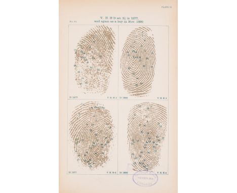
NO RESERVE Galton (Francis) Finger Prints, 16 lithographed plates, one double-page, 1892; English Men of Science: Their Nature and Nurture, 1874; Natural Inheritance, illustrations, 1889; The Narrative of an Explorer in Tropical South Africa, 4 tinted lithographed plates, folding colour map, foxing, 1853, first editions, all but the first with advertisement leaf at end, all but the second ex-library copies with stamps, original cloth, the last pictorial gilt, all rubbed, wear to spine ends, the second recased, the last rebacked preserving original spine; and 11 others, Galton, Darwin etc., 8vo & 4to (15)
Lot 119
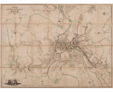
NO RESERVE Bath.- Holloway & Son, engravers of Bath. Plan of the City and Borough of Bath and its suburbs, engraved plan with some boundaries marked with outline hand-colouring, 725 x 950 mm (28 1/2 x 37 1/2 in), dissected and mounted on linen, some spotting, browning and surface dirt, brown paper ends, folding with lower cover only, upper cover and spine missing, 8vo, 1852; together with Bowen's 'An Improved Map of the County of Somerset Divided into it's Hundreds', and a good group of 8 maps and plans of Bath, including Pratt & Marshall's 'An Improved Map of the Villages, Roads, Farm Houses, &c., Five Miles round the City of Bath', 1787, Meyler's 'Plan of the City of Bath', C. Harcourt Masters 'Map of 24 Miles Round the City of Bath', and 'Houlston's New Large-Scale Plan of Bath and Suburbs', a copy of 'Cary's Traveller's Companion', 1791, all folding, mainly 19th century; with 2 others (12)
Lot 124
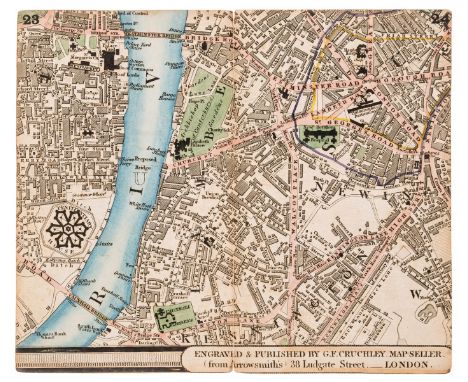
NO RESERVE London.- Cruchley's New Plan of London in Miniature..., letterpress title, 8pp. index and advertisement leaf, hand-coloured double-page key map and 15 double-page hand-coloured engraved maps numbered 1-30 and pasted back to back in book form, a little browned, especially final double-page, a few short splits to folds, original cloth, yellow paper label to upper cover, lacking spine, covers detached, [c.1830] § Grand Panorama of London (The), from the Thames, long folding wood-engraved map, staining to joints, some splits and fraying to folds, loose in binding, folding concertina style into original cloth, gilt, Charles Evans, [1844] Reynolds & Sons (James) The Oarsman's and Angler's Map of the River Thames from its Source to London Bridge, long folding hand-coloured map mounted on linen, light soiling, one or two splits to folds, folding concertina-style into original cloth, damp-stained, James Reynolds, [1880s], all rubbed or worn; and c.15 others on London, 8vo et infra (c.20)
-
109182 item(s)/page