We found 109198 price guide item(s) matching your search
There are 109198 lots that match your search criteria. Subscribe now to get instant access to the full price guide service.
Click here to subscribe- List
- Grid
-
109198 item(s)/page


Lot 525
Sturgeon, Country Timber Framed Houses, limited edition print 548/850, signed lower right; pair of prints of Rotherham, Church St - Chapel of Our Lady on Rotherham Bridge by Peter D. Bradshaw; Rother Boiler Co Ltd, Meadow Banks, Rotherham unframed poster and a reproduction Fairbank map of Sheffield.

Lot 50
Australasia.- Australia.- Warburton (Col. Peter Egerton) Journey across the Western Interior of Australia, first edition, half-title, wood-engraved portrait, title-vignette of Warburton beetle and 8 plates, folding map with route supplied in red, 40pp. publisher's catalogue at end, faint ink inscription at head of title and another to half-title, map with short tear to fold repaired with sticky tape, original green pictorial cloth, gilt, bookseller's ticket Angus & Robertson of Sydney to inside front board, bookplate removed, very slightly rubbed, an excellent copy, [Ferguson 18187; Wantrup 201], 8vo, 1875.⁂ Warburton suffered enormous hardship on his journey, having got lost in the Great Sandy Desert, and was unable to prepare his journals for publication. The scientific results were presented for him by others including Sir Joseph Dalton Hooker and John Gould.
Lot 70
Polar.- Arctic.- Parry (Capt. William Edward) Journal of a Voyage for the Discovery of a North-West Passage from the Atlantic to the Pacific; performed in the years 1819-20, in His Majesty's Ships Hecla and Griper...with an Appendix, first edition, 20 engraved maps and plates, some aquatint, 4 folding, folding letterpress table, errata slip at end, 1821; A Supplement to the Appendix of Captain Parry's Voyage...1819-20, containing an Account of the Subjects of Natural History, half-title, 6 engraved plates, 1824, together 2 works in 1 vol., tissue guards, some foxing to plates, contemporary diced calf, gilt, rubbed, rebacked preserving old gilt spine with ship motifs and red roan label, 1821-24; Journal of a Second Voyage for the Discovery of a North-West Passage...in the Years 1821-22-23..., 31 engraved or lithographed plates and plans, some aquatint after Capt. George Lyon, and 8 large folding engraved maps and panoramas at end, some light foxing and wrinkling from damp (but no staining), contemporary half calf, rubbed, rebacked, green roan labels (one renewed), 1824; Journal of a Third Voyage for the Discovery of a North-West Passage...in the years 1824-25..., errata leaf, 10 engraved maps and plans, one folding, and large folding map at end (tear repaired), ex-Board of Trade library copy with ink stamp at head of title, contemporary calf, gilt, rubbed, rebacked, 1826; Narrative of an Attempt to reach the North Pole...in the year MDCCCXXVII, errata leaf, 6 engraved plates and plans, large folding engraved map at end, marginal foxing and damp-staining, original boards, uncut, corners worn, rebacked, 1828 § Sabine (Edward, editor) The North Georgia Gazette, and Winter Chronicle, half-title, woodcut coat-of-arms as title-vignette (repeated at head of each issue), title lacking small portion at lower edge not affecting text, lightly browned with occasional spotting, modern cloth-backed boards, uncut, 1821, together 6 works in 5 vol., first editions, [Sabin 58860, 58861, 58867 & 58868 & 55714], 4to (5) ⁂ Complete set of Parry's Arctic voyages and including The North Georgia Gazette which was produced by the crew on the first voyage when they got stuck in the ice. The second voyage includes detailed descriptions and plates of the native inhabitants and the third voyage made many important scientific discoveries. The final voyage was an unsuccessful attempt to reach the North Pole via Spitsbergen using sledge-boats and reindeer.Saleroom Notice: This is not a complete set; it does not include the scarce Appendix to the Second Voyage published in 1825

Lot 26
Americas.- South America.- Mawe (John) Travels in the Interior of Brazil; with...Account of the Gold and Diamond Districts, second edition, half-title, engraved map and 8 hand-coloured plates on 5 sheets, most aquatint (1 hand-coloured), tissue guards, advertisement leaf at end, light foxing, contemporary calf, gilt, a little rubbed, spine worn and slightly defective at head, [Sabin 46992; cf. Abbey, Travel 709, 1825 edition], 8vo, 1821.⁂ Scarcer than the first edition of 1812, now in 8vo format but with the plates hand-coloured; contains some of the earliest descriptions of the gold, diamond and topaz mines of Brazil.

Lot 370
Dolmen Press.- le Brocquy (Louis).- Kinsella (Thomas, translator) The Tain, one of 1,750 copies, printed in red and black, map (slightly offset), illustrations by Louis le Brocquy, prospectus and order form loosely inserted, original buckram, dust-jacket, browned, some light wear to spine ends, decorated slip-case, joints a little weak, extremities slightly rubbed, preserved in custom drop-back box lettered in gilt, [Miller 154], small folio, Dublin, Dolmen Editions, 1969.
Lot 5
Africa.- Burton (Sir Richard Francis) The Lake Regions of Central Africa, 2 vol., first edition, half-titles, folding engraved map with partial hand-colouring, 12 chromoxylograph plates, wood-engraved illustrations, light foxing to some plates, map with tear at fold, contemporary ink inscription to front free endpaper, endpapers foxed, contemporary tan calf, gilt, spines gilt with roan labels, a little rubbed, [Penzer p.65], 8vo, 1860.⁂ Account of the Royal Geographical Society expedition with John Hanning Speke in search of the source of the Nile in 1858-59. They started at Zanzibar and travelling through East Africa discovered Lake Tanganyika. After Burton became ill Speke carried on without him, as he did not believe that their location was the source. He was the first European to discover what he named Lake Victoria and claimed it to be the source but Burton disputed it, leading to a long-running bitter feud between them (see also lot 17).
Lot 15
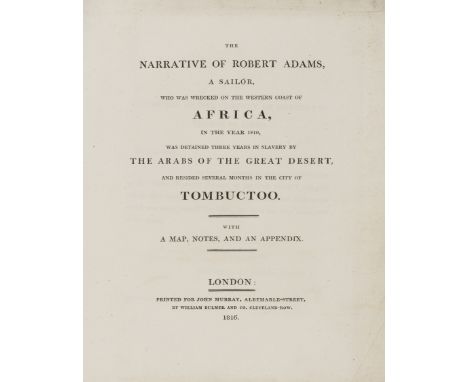
Africa.- Percival (Capt. Robert) An Account of the Cape of Good Hope, first edition, first issue with uncorrected head-line on p.247, very light foxing, contemporary tree calf, spine gilt, rubbed and a little scuffed, spine worn at foot, 1804 § Adams (Robert) The Narrative of Robert Adams, a Sailor, who was wrecked on the western coast of Africa...detained three years in slavery...and resided...in the city of Tombuctoo, first edition, folding engraved map with routes supplied in blue and yellow, title and map becoming loose, original boards, uncut, rubbed, spine worn and defective, 1816, 4to (2)
Lot 22
Americas.- North America.- Whymper (Frederick) Travel and Adventure in the Territory of Alaska, first edition, half-title, folding engraved map, 16 plates, 32pp. publisher's catalogue at end, spotted, map torn, 1868 § Milton (Viscount) & W.B.Cheadle. The North-West Passage by Land, second edition, 2 folding engraved maps with partial hand-colouring (one linen-backed), old ink ownership stamp at head of title, light foxing, contemporary half calf, spine gilt, [1865] § Rattray (Alexander) Vancouver Island and British Columbia, first edition, half-title, 2 folding maps, folding table, 4 tinted lithographed plates, tissue guards, 16pp. publisher's catalogue at end, some light spotting or browning, 1862 § [Traill (Catherine Parr)] The Backwoods of Canada, second edition, half-title, map, 1836 § Atkinson (Rev. Christopher W.) A Guide to New Brunswick, British North America, &c,., second edition, folding map, lithographed plate, Edinburgh, 1843 § King (Edward) The Southern States of North America, 4 vol., double-page colour map, foxing, 1875, all with plates and/or illustrations, mostly wood-engraved, all but the second original cloth, a little rubbed, some spines slightly faded; and 7 others on North America/Canada, v.s. (14)
Lot 88
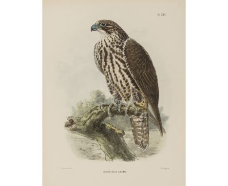
Birds.- Sharpe (Richard Bowdler) Scientific Results of the Second Yarkand Mission: Aves, 24 hand-coloured lithograph plates by J.G. Keulemans, W. Hart and J. Smit, without the folding map, title lightly foxed, original printed upper wrapper bound in, modern cloth, [Fine Bird Books p.107; Nissen IVB 861], 4to, 1891.⁂ In 1873, the second Yarkand mission, under Sir Douglas Forsyth, was sent by the Viceroy of India, Lord Northbrook, to the court of Yakub Beg, ruler of Kashgaria. Ferdinand Stoliczka, the mission's geologist and naturalist, died on the return journey but his collections and notes were edited by various scientists to form the complete 14-part report, issued between 1874 and 1891. The ornithological section was edited by Richard Bowdler Sharpe.
Lot 357
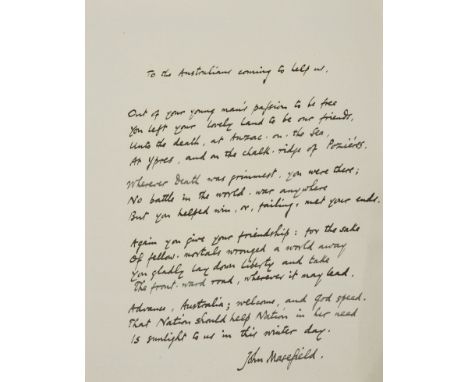
Masefield (John, poet and writer, Poet Laureate from 1930, 1878-1967) To the Australians coming to help us, autograph poem, 1p., signed at foot, [1940]; Right Royal, number 460 of 500 copies signed by the author, map, book-label of Laurence Hodson, endpapers browned, original boards, t.e.g., others uncut, spine slightly soiled, 1920; Selected Poems, number 387 of 530 copies signed by the author, portrait, original boards, t.e.g., others uncut, rubbed, 1922; and 8 others by Masefield, mostly first editions, some with signature of Laurence or Will Hodson, one inscribed to Will by Con (?Constance Masefield, "it is a blank Christmas in many ways for many of us"), and a few ephemeral items, 8vo (a bundle)⁂ The poem was written by Masefield as Poet Laureate and concerns Australia's entry into the Second World War. It refers to the contribution by Australian soldiers at Anzac, Ypres and Pozières, "...Wherever Death was grimmest, you were there...Again you give your friendship: for the sake / Of fellow mortals wronged a world away...Advance, Australia; welcome, and God speed./ That Nation should help Nation in her need / Is sunlight to us in this winter day.". Masefield had served as a hospital orderly in France during the First World War and wrote a history of the Gallipoli campaign. With the poem is a cutting from the Melbourne newspaper The Age of 24th January 1940 quoting the poem.

Lot 126
Middle East.- Burton (Sir Richard Francis) Personal Narrative of a Pilgrimage to El Medinah and Meccah, 2 vol., second edition, chromolithographed frontispieces, 11 tinted or chromolithographed plates, folding map, plans (2 folding), plate guards, half-titles, slightly browned, ink signatures on front free endpapers, original blue decorated cloth, gilt spines, a fine copy, 8vo, 1857.
Lot 44
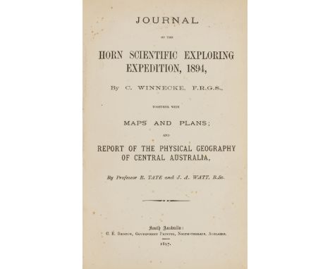
Australasia.- Australia.- Lindsay (David) Journal of the Elder Scientific Exploring Expedition, 1891-2, first edition of the public account (preceded by issue in parliamentary papers), [one of 500 copies], with the 2 large folding maps, one colour (both loose), Adelaide, C.E.Bristow, 1893 bound with Handbook of Instructions for the Guidance of the Officers of the Elder Scientific Exploration Expedition to the Unknown Portions of Australia, first edition, Adelaide, printed by W.K.Thomas & Co., 1891, together 2 vol. in 1, with a folding colour map 'Map of Australia shewing Explorations' bound in at end (c.485 x 600mm.) § Winnecke (Charles) Journal of the Horn Scientific Exploring Expedition, 1894...and Report of the Physical Geography of Central Australia, by Professor R.Tate and J.A.Watt, first public edition, [one of c.650 copies], 24 photographic plates, 3 folding charts/tables and large folding map (all loose), very light spotting to title, Adelaide, C.E.Bristow, 1897, texts in uniform later brown buckram, slightly rubbed, [Ferguson 9409a, 9409 & 18686a; Wantrup 208, 209 & 211], 8vo (2 & loose maps)⁂ The first two relate to the exploratory expedition into the central interior financed by Sir Thomas Elder; it did not achieve a great deal as the leader David Lindsay fell out with the scientists in the party and the expedition had to be abandoned. The expedition financed by William Austin Horn described in the third item was more successful, with discoveries in geology, anthropology, botany and zoology, but this time the leader Winnecke disagreed with Horn and so his account was published separately from the official record. It was first issued as a parliamentary paper the previous year but hastily suppressed by the state premier at Horn's request.
Lot 42
Australasia.- Australia.- King (Capt. Phillip Parker) Narrative of a Survey of the Intertropical and Western Coasts of Australia, performed between the years 1818 and 1822, 2 vol., first edition, second issue with cancel titles (as usual), lacking half-titles and colophon leaf at end of vol.2, with 2 folding engraved maps and 13 engraved plates, mostly aquatint views after King, others natural history, one folding, wood-engraved illustrations, errata slips pasted to final leaves, some foxing to maps and plates, first map torn and slightly frayed at fold, folding plate 'Kingia Australis' creased and soiled, contemporary half calf, spines gilt, rubbed and faded, [Abbey, Travel 573; Ferguson 1130; Wantrup 84b], 8vo, 1827.⁂ King was the first Australian-born hydrographer, son of Philip Gidley King the third Governor of New South Wales. He was commissioned to explore and chart the north and north-western coasts of Australia, completing areas not surveyed by Flinders, to establish British claims to the territory. The work was first issued in 1826 but is very rare, it was then re-issued with new title-pages the following year. "An essential inclusion in any collection of books relating to Australian coastal discovery". Wantrup p.162

Lot 25
Americas.- South America.- Maw (Henry Lister) Journal of a Passage from the Pacific to the Atlantic...and descending the River Marañon, or Amazon, folding engraved map (lightly offset on title), contemporary calf, gilt, spine faded, 1829 § Gardner (George) Travels in the Interior of Brazil...and the Gold and Diamond Districts, second edition, half-title, tinted lithographed frontispiece, map, original purple cloth, gilt, spine faded, lower cover stained, 1849 § Hadfield (William) Brazil, the River Plate, and the Falkland Islands, first edition, lithographed portrait, 2 folding maps (?of 3), one large and hand-coloured (short tear at edge), the other of Falklands, wood-engraved illustrations, original cloth, 1854, all a little rubbed, 8vo et infra (3)
![Voyages.- Cook (Capt. James) [First Voyage].- [Hawkesworth (John)] An Account of the Voyages...for making Discoveries in the](https://cdn.globalauctionplatform.com/46142c27-9756-41a8-8d56-a84f00b4fee4/a6f7f4a2-9444-46ee-ccdf-5d686ea3e9b3/468x382.jpg)
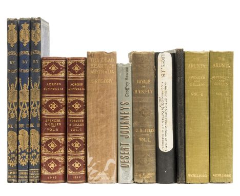
Lot 75
Voyages.- Cook (Capt. James) [First Voyage].- [Hawkesworth (John)] An Account of the Voyages...for making Discoveries in the Southern Hemisphere...], Atlas only, 52 engraved maps and plates, 14 folding or double-page, including map of 'Straights of Magellan', some foxing or soiling, light water-staining affecting some plates, mostly towards end, contemporary half calf, worn, upper cover detached with first 2 maps loose, folio, [1773].
Lot 47
Australasia.- Australia.- Spencer (Sir Baldwin) and F.J.Gillen. The Arunta: a Study of a Stone Age People, 2 vol., first edition, folding map, 4 colour plates, one folding, illustrations, notes and cuttings loosely inserted, bookplate of Arthur Bulleid, original cloth, 1927; Across Australia, 2 vol., 2 folding maps, illustrations, contemporary half red morocco, spines gilt, a little marked, 1912 § Martin (R.Montgomery) Australia..., Divisions I-III [complete], 10 engraved portraits and plates only (of 11, lacking portrait of Earl Howe) and 8 double-page maps hand-coloured in outline, bookplate of John Hellicar, original cloth, gilt, rubbed, London & New York, [1853], first editions; and 5 others, Australia, including a defective mixed set of Jukes's Narrative of the Surveying Voyage of H.M.S.Fly' and a manuscript naval journal of a voyage to Australasia in H.M.S.Nelson from 1884-85 calling at Hobart, Sydney and New Guinea, 8vo & 4to (12)⁂ Arthur Bulleid (1862-1951), archaeologist and antiquarian.
Lot 67
Polar.- Arctic.- Franklin (Sir John).- M'Clure (Capt. Robert) The Discovery of the North-West Passage by H.M.S. "Investigator"..., edited by Commander Sherard Osborn, 4 lithographed plates, folding hand-coloured engraved map (foxed and offset), occasional spotting to plates, 1856 § M'Clintock (Capt. Francis) The Voyage of the 'Fox' in the Arctic Seas. A Narrative of the Discovery of the Fate of Sir John Franklin..., 3 folding maps, all linen-backed, folding facsimile, wood-engraved plates, light foxing, 1859, first editions, contemporary calf, gilt, spines gilt, very slightly rubbed, [Sabin 43073 & 43043], 8vo (2)⁂ M'Clure failed in his attempt to rescue Sir John Franklin but he succeeded in completing the first north-west passage, from Alaska to the Atlantic. The M'Clintock expedition was the final one sent by Lady Franklin in search of her husband and found evidence of the crew and a note recording Franklin's death on King William Island.
Lot 36
Australasia.- Australia.- Eyre (Edward John) Journals of Expeditions of Discovery into Central Australia, and Overland from Adelaide to King George's Sound, 2 vol., first edition, 2 folding engraved maps with partial hand-colouring (not in pocket but tipped to stubs), 22 engraved or lithographed plates (6 of natural history), vol.1 with advertisement leaf at beginning and 4pp. publishers' catalogue at end, vol.2 with 4pp. at beginning and 8pp. at end, some foxing and soiling, ex-library copy with stamps removed (one or two very faint traces), bookplate of John Thackray Bunce, [Ferguson 4031; Wantrup 133a], 1845 § Hodgson (Christopher Pemberton) Reminiscences of Australia, with Hints on the Squatter's Life, lithographed frontispiece, folding map, [Ferguson 4310; Wantrup 140], 1846 § Gouger (Robert) South Australia in 1837..., [Ferguson 2497; Not in Wantrup], 1838 § Young Emigrants (The); or, a Voyage to Australia, Emigrant Tracts No.V-VII, 3 parts in 1 vol., wood-engraved frontispiece, lightly browned, [Not in Ferguson or Wantrup], SPCK, 1850, all first editions, original blind-stamped cloth, rubbed and faded, the first rebacked preserving original spines (faded and worn), 8vo et infra (5)
Lot 9
Africa.- Burton (Sir Richard Francis) and Verney Lovett Cameron. To the Gold Coast for Gold: A Personal Narrative, 2 vol., first edition, half-titles, 2 folding maps, colour frontispiece, illustrations, vol.1 with 32pp. publishers' catalogue at end, first map slightly soiled and frayed at edge, very occasional spotting, original decorative red cloth, gilt, rubbed and slight mottled by damp, spines faded, [Penzer p.106], 8vo, 1883.⁂ Burton defied an order by the Foreign Office not to travel for commercial purposes and set out to explore and survey the Gold Coast with Cameron in search for gold, on behalf of the Guinea Gold Coast Mining Co. They found evidence of gold and other minerals but were forced to return to England by the Foreign Office and to forfeit all rights to the deposits.

Lot 369
Dolmen Press.- le Brocquy (Louis).- Kinsella (Thomas) The Tain, one of 1,750 copies, this number 2 of 6 specially-bound copies signed by Liam Miller, Louis le Brocquy and Thomas Kinsella, printed in red and black, map (slightly offset), illustrations by Louis le Brocquy, with pencil notes "Liam Miller's copy" to front free endpaper, specimen setting sheet loosely inserted, original decorative vellum after designs by le Brocquy, light discolouration to spine, slip-case, preserved in custom calf-backed drop-back box (lightly spotted), [Dolmen XXV 154], small folio, Dublin, Dolmen Editions, 1969.
Lot 29
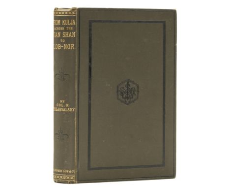
Asia.- Prejevalsky (Nikolai) From Kulja, across the Tian Shan to Lob-Nor, including Notices of the Lakes of Central Asia, translated by E. Delmar Morgan, first English edition, 2 folding colour maps, 32pp. publishers' catalogue at end, pencil signature at head of title, main map with some tears to folds and small stain, bookplate of Alexander Thoms, upper hinge weak, original cloth, very slightly rubbed, small worn patch and tear to lower cover, 8vo, 1879. ⁂ The author's second expedition in Central Asia but again he was unable to get as far as Lhasa. He did, however, manage to collect many specimens of plants, birds and animals and during the course of various expeditions discovered wild Bactrian camels and the wild Mongolian horse named after him.
Lot 12
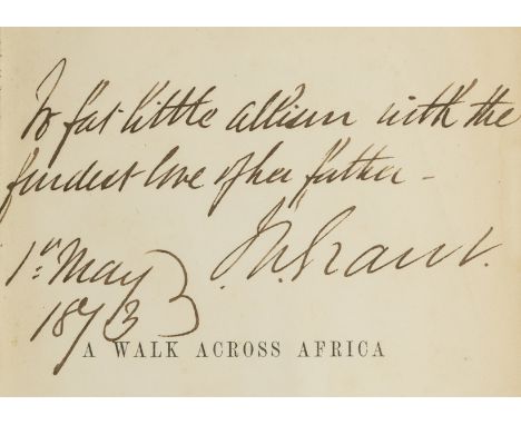
Africa.- Grant (James Augustus) A Walk across Africa or Domestic Scenes from my Nile Journey, first edition, half-title, signed and inscribed by the author "To fat little Allison with the fondest love of her father - J. A.Grant 1st May 1873" in ink on half-title, folding map hand-coloured in outline in pocket at end (lightly browned), with 40pp. publisher's catalogue at end (not found in all copies), very occasional soiling, original pictorial green cloth, gilt, a little rubbed, small hole to upper joint, recased, new endpapers, [Czech p.66], 8vo, Edinburgh and London, 1864.⁂ Account of the author's expedition with John Hanning Speke to prove Speke's claim that Lake Victoria, which he had discovered in 1858, was the source of the Nile. "A monumental work of exploration". Czech
Lot 73
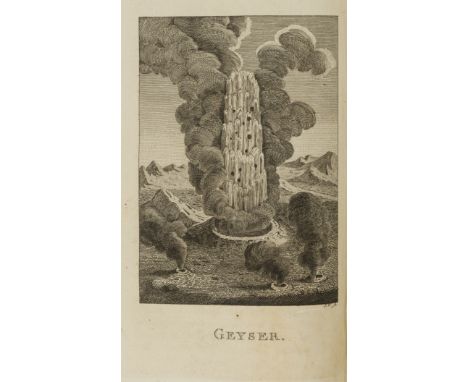
Polar.- Iceland.- Troil (Uno von) Letters on Iceland: containing observations on...Volcanos, Basaltes, Hot Springs..., made, during a Voyage undertaken in the Year 1772, by Joseph Banks...Dr.Solander..., first Dublin edition, half-title, engraved plate and folding map, c1 & c2 (preliminaries) misbound after contents, contemporary calf, red morocco label, a little rubbed, a few scuffs, lower corners bumped, 8vo, 1780.⁂ By the First Chaplain to the King of Sweden and first published in Stockholm, in German, in 1777. Having accompanied Capt. Cook on his first voyage Banks and Solander were planning to travel with him again on his second voyage but it could not accommodate the large party of scientists demanded by Banks so he went to Iceland instead. This is the first major work in English on Iceland and includes a plate of the eponymous geyser.
![Australasia.- New Zealand.- [Craik (John Lillie)] The New Zealanders, reprint, map, illustrations, original green cloth, spin](https://cdn.globalauctionplatform.com/46142c27-9756-41a8-8d56-a84f00b4fee4/1c9cf02d-0f8d-4c5f-9f0d-b22b4a31a931/468x382.jpg)
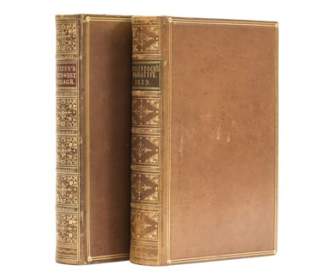
Lot 52
Australasia.- New Zealand.- [Craik (John Lillie)] The New Zealanders, reprint, map, illustrations, original green cloth, spine gilt and slightly faded, [1847] § West of England Board of the New Zealand Company. Latest Information from the settlement of New Plymouth, on the coast of Taranake, New Zealand, first edition, wood-engraved frontispiece, advertisement leaf, original printed wrappers, slightly soiled, 1842 § Trollope (Anthony) New Zealand, first separate edition, folding map, original reddish-brown cloth, lightly stained, 1874 § Hector (James) Handbook of New Zealand. Sydney International Exhibition 1879, first edition, 12 folding tables of statistics, 2 folding lithographed maps, title soiled and creased at edges, original printed orange wrappers, soiled and creased, a few small stains, Wellington, 1879 § Brett's Handy Guide to New Zealand, edited by E.Ernest Bilbrough, Jubilee Edition, 8 maps, 7 folding, illustrations, ink signature on title, original red cloth, spine rubbed and faded, Auckland and London, 1890, a little rubbed, [Hocken p.46, 103, 287, 319 & 494], 8vo et infra (5)

Lot 153
Warwickshire Estate Map & elsewhere.- Robins's Estate Act 1859. Estates in The Parishes of Aston-juxta-Birmingham... Warwick... Handsworth... Stafford... Llandanwg... Merioneth, manuscript on vellum, 98pp., decorated title, large folding map (some slight foxing) and 22 plans on vellum, also a copy of the published Act of Parliament bound in, some slight soiling on plans, original morocco, gilt, extensively rubbed, g.e., large folio, 1859.⁂ A detailed assessment and valuation of the property of Josiah Robins of Birmingham, probably relating to a local solicitor of that name. Comprises a Memorandum of Agreement from the beneficiaries of Josiah Robins's estate with detailed schedules of all the property with accompanying maps and plans, showing tenants or lessees, extent in acres, leases and yearly rents.
Lot 63
Polar.- Antarctica.- Ross (Capt. Sir James Clark) A Voyage of Discovery and Research in the Southern and Antarctic Regions, during the years 1839-43, 2 vol., first edition, 8 tinted lithographed plates, one double-page and folding, 8 engraved maps, 3 folding, unpaginated half-titles to each chapter, most with wood-engraved vignette, wood-engraved illustrations, 16pp. publisher's catalogue at end of vol.1, light foxing, mostly to plates and maps, some plates with light marginal water-staining, large folding map with short tear to inner edge repaired, damp-staining to rear endpapers, original pictorial blue cloth, gilt, rubbed and faded, lightly damp-stained, [Abbey, Travel 610; Ferguson 4636; Rosove 276; Sabin 73367; Spence 993; Taurus Coll. 9], 8vo, 1847.⁂ Ross was the nephew of Sir John Ross and served under him on his uncle's first Arctic voyage in search of a Northwest Passage in 1818. He also accompanied Sir William Parry on his four Arctic expeditions between 1819 and 1827, and his uncle again on Sir John's second Arctic voyage from 1829 to 1833. Between 1839 and 1843 Ross commanded this Antarctic expedition in the vessels HMS Erebus andTerror and charted much of the coastline of the continent, with Joseph Dalton Hooker the assistant surgeon. In 1841, James Ross discovered the Ross Sea, Victoria Land, and the volcanoes Mounts Erebus and Terror, as well as the low, flat-topped ice shelf they called the Victoria Barrier, later named "Ross Ice Shelf" in his honour. "Once this account became public, no one could doubt there was a great southern continent of immense proportions to be explored." Taurus Collection
Lot 64
Polar.- Arctic.- Back (Sir George) Narrative of the Arctic Land Expedition to the Mouth of the Great Fish River, and along the Shores of the Arctic Ocean in the years 1833, 1834 and 1835, 16 engraved or lithographed plates, folding engraved map at end, bookplate of John V.Stewart, 1836; Narrative of an Expedition in H.M.S. Terror...on the Arctic Shores in the years 1636-7, 12 lithographed plates, most tinted, folding engraved map, 12pp. publisher's catalogue at end, occasional browning, mostly to tissue guards, map with short tear to inner edge, 1838, first editions, original cloth, spines a little faded, the first with light staining to boards, the second recased with new endpapers, [Sabin 2613 & 2617], 8vo (2)
Lot 110
China.- Staunton (Sir George) An Authentic Account of an Embassy from the King of Great Britain to the Emperor of China, Atlas vol. only, 44 engraved maps and plates, some folding or double-page, foxing and soiling, mostly to margins, small ink stamp to verso of first and last plates, bookplate of John Stafford Reid Byers, later green half morocco, rubbed and repaired, rebacked, folio, [1797].⁂ Without the two accompanying text volumes, this atlas illustrates the official account of Lord Macartney's voyage and embassy to the Qianlong emperor in 1792-94, the failure of which led to the establishment of the British trading post at Hong Kong. The fine plates by Alexander include birds, views of palaces, temples, barges and a military post, and there is also a detailed map of Macao.
Lot 28
Asia.- Prejevalsky (Nikolai) Mongolia, the Tangut Country, and the Solitudes of Northern Tibet being a Narrative of Three Years' Travek in Eastern High Asia, translated by E.Delmar Morgan, 2 vol., first English edition, half-titles, photographic portrait, folding lithographed map hand-coloured in outline, 12 wood-engraved plates, illustrations, ink signature to half-titles, map with short tear repaired, small stain to index leaves in vol.2, upper hinge of vol.1 reinforced, original pictorial cloth, gilt, spines gilt, rubbed, traces of labels where removed from upper covers, split to lower joint of vol.1, spine ends worn, 8vo, 1876.⁂ Account of the author's first attempt to reach Lhasa.
Lot 69
Polar.- Arctic.- Lyon (Capt. George Francis) The Private Journal...during the Recent Voyage of Discovery under Captain Parry, 7 engraved plates and folding map, lacking half-title, some light offsetting, contemporary calf, spine gilt, boards rather worn, 1824; A Brief Narrative of an Unsuccessful Attempt to Reach Repulse Bay... in His Majesty's Ship Griper, 7 engraved plates and folding map, 8pp. publisher's catalogue at end, some foxing and offsetting, old boards, uncut, rebacked in calf, boards spotted, 1825 § Fisher (Alexander) A Journal of a Voyage of Discovery to the Arctic Regions, in His Majesty's Ships Hecla and Griper..., no half-title (as usual), 2 engraved maps, one folding, wood-engraved illustrations, light offsetting from maps, old ink ownership stamp at head of title, contemporary half calf, rubbed, rebacked, 1821, first editions, [Sabin 42853, 42851 & 24453], 8vo (3)
Lot 17
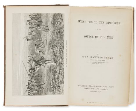
Africa.- Speke (John Hanning) What Led to the Discovery of the Source of the Nile, first edition, half-title, wood-engraved frontispiece, 2 maps (one folding, one double-page), 32pp. publishers' catalogue at end, some foxing, mostly at beginning and end, advertisement & contents leaves plus folding map all loose, original terracotta cloth, a little rubbed and marked, rebacked preserving original spine, corners slightly worn, [Czech p.151], 8vo, Edinburgh & London, 1864. ⁂ Account of Speke's first expedition in search of the source of the Nile, undertaken with Sir Richard Burton in 1856-59, and which caused the antagonism between them (see also lot 5).
Lot 10
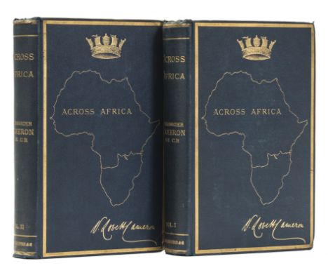
Africa.- Cameron (Verney Lovett) Across Africa, 2 vol., first edition, half-titles, wood-engraved frontispieces and 27 plates, 4 plates of facsimiles (3 folding), folding colour map in pocket at end (slightly browned), numerous wood-engraved illustrations, 4pp. & 8pp. publisher's catalogues at ends, Humphrey Winterton's copy with his book-label, original pictorial cloth, gilt, slightly rubbed, corners bumped, a good copy, 8vo, 1877. ⁂ Fascinating account of a journey across Africa, originally in search of Livingstone but on learning of his death continued as exploration. Cameron describes the manners and customs of the indigenous peoples encountered, and comments on the slave trade and its consequences; he was the first European to cross Equatorial Africa from east to west.
Lot 6
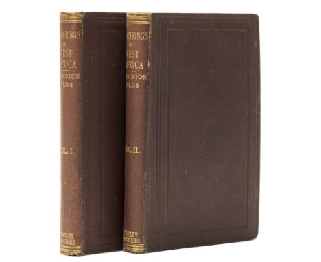
Africa.- Burton (Sir Richard Francis) Wanderings in West Africa from Liverpool to Fernando Po. By a F.R.G.S., 2 vol., first edition, half-titles, folding lithographed map, wood-engraved frontispiece in vol.2, light spotting at beginning and ends, original dark purple cloth, spines with author's name, a little rubbed, very slight damp-mottling, spines faded, [Penzer p.69], 8vo, 1863. ⁂ In 1861 Burton took up the post of British consul on the Spanish island of Fernando Po (Bioko, off Cameroon in West Africa) and this work includes descriptions of the gold-mining prospects in both Sierra Leone and Nigeria. At the time Burton was in dispute with Speke over the source of the Nile and was infuriated by the Royal Geographical Society for choosing Speke to lead a second expedition to establish his claim, causing him to issue this work anonymously, although his name appears on the spines.
Lot 31
Asia.- Stein (Sir Marc Aurel) On Ancient Central-Asian Tracks: Brief Narrative of Three Expeditions in Innermost Asia and North-Western China, first edition, half-title, plates, some colour, some folding, folding colour map, advertisement leaf at end, original terracotta cloth, gilt medallion on upper cover, t.e.g., others uncut, a little rubbed and damp-stained, 8vo, 1933.
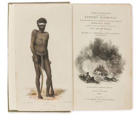
Lot 46
Australasia.- Australia.- Mitchell (Sir Thomas Livingstone) Three Expeditions into the Interior of Eastern Australia; with descriptions of...Australia Felix , and of the present colony of New South Wales, 2 vol., second edition, titles with wood-engraved vignettes, folding engraved map hand-coloured in outline in pocket at beginning of vol.1, 51 plates and maps, most lithographed, some hand-coloured, a few folding, vol.1 with 8pp. 'Opinions of the Press' bound before text rather than at beginning (soiled) and 16pp. publisher's catalogue at end, occasional light foxing or soiling, folding map with a few short tears to folds, second issue binding of original blind-stamped green cloth, spines gilt with titles and kangaroos, emus and boomerangs, rubbed and lightly stained, spines faded, new endpapers, [Ferguson 2811; Wantrup 125], 8vo, 1839. ⁂ Account of expeditions into the interior of Australia by the Surveyor General of New South Wales, and containing important information on aboriginal life.
Lot 51
Australasia.- New Zealand.- Barraud (Charles Decimus) and W.T.L.Travers. New Zealand: Graphic and Descriptive, first edition, additional lithographed decorative title with mounted oval chromolithographed vignette of 'The Remarkables', list of subscribers, map, 24 mounted chromolithographed plates after Barraud, 6 plates of tinted lithographs, wood-engraved illustrations, text with light offsetting from plates, plates clean and bright, slightly trimmed, a couple with minor marginal tears/fraying to outer margin (repaired), with additional colour wood-engraved plate 'The Haunt of the Lyre Bird' after Louis Buvelot bound in at end (lightly spotted, central horizontal crease where previously folded), modern half green morocco, part of original gilt pictorial cloth cover with title loosely inserted (stained), folio, 1877.⁂ Including scenes of Wellington, Auckland, Tarawera Lake, the geothermal terraces of Rotomahana, and Mount Cook.
Lot 57
Middle East.- Burckhardt (John Lewis) Travels in Arabia..., first edition, half-title, engraved folding map and 4 plans, advertisement leaf at end, light foxing, ink inscription "H.G.Lyons R.E. 1891" on half-title, old roan-backed cloth, rubbed, spine faded, [cf. Blackmer 239, second edition], 4to, 1829. ⁂ Burckhardt travelled to Mecca and Medina in 1814 disguised as an Arab Sheikh and through his extensive knowledge of Arabic and Muslim practices managed to avoid exposure. A second, 8vo, edition appeared in the same year.Henry George Lyons F.R.S. (1864-44), geologist and Director of the Science Museum who introduced working models of machines. As a lieutenant in the Royal Engineers he was posted to Cairo in 1890 and surveyed several ancient Egyptian temples at Buhen.
![Voyages.- Cook (Capt. James).- [Marra (John)] Journal of the Resolution's Voyage, in 1772, 1773, 1774, and 1775, on Discovery](https://cdn.globalauctionplatform.com/46142c27-9756-41a8-8d56-a84f00b4fee4/0117b8f2-08c7-4038-f214-5dfbb7208f55/468x382.jpg)
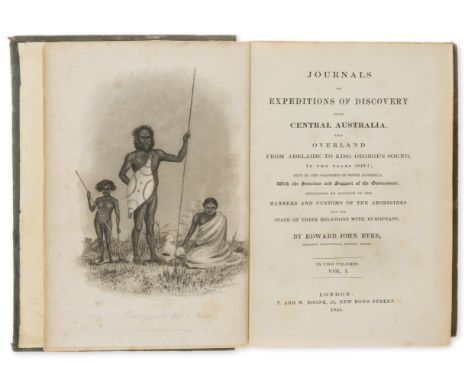
Lot 133
Voyages.- Cook (Capt. James).- [Marra (John)] Journal of the Resolution's Voyage, in 1772, 1773, 1774, and 1775, on Discovery to the Southern Hemisphere...also a Journal of the Adventure's Voyage..., first edition, folding engraved map, 5 engraved plates, a few ink annotations or corrections, map a little creased, plates with light offsetting from text, one or two small stains, contemporary sprinkled calf, red morocco label, a little rubbed and marked, small chip to head of upper joint, [Beddie 1270; Hocken p.14; Sabin 16247], 8vo, for F. Newbery, 1775.⁂ The earliest authentic account of Cook's second voyage, published eighteen months before Cook's official version, and the first published book to give an eye-witness account of the Antarctic regions. The author was an Irish gunner's mate on the Resolution and accompanied Cook on both his first and second voyages.
Lot 56
Australasia.- Papua New Guinea.- Rosenberg (C.B.H. von) Reistochten naar de Geelvinkbaai op Nieuw-Guinea..., first edition, tinted lithographed portrait and 19 plates and maps, some tinted, 5 of birds (4 hand-coloured), folding map in pocket at end, light foxing to plate of cassowary, original limp printed boards, a little foxed and soiled, spine reinforced, upper cover detached, 4to, The Hague, 1875.
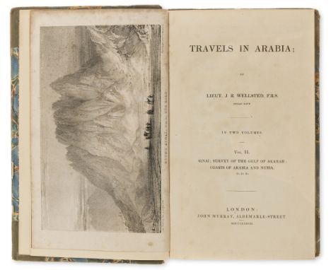
Lot 61
Middle East.- Wellsted (Lt. James Raymond) Travels in Arabia, 2 vol., first edition, 5 engraved maps including large folding map of Oman with route supplied in red, 7 lithographed plates, vol.1 with final otherwise blank imprint leaf, plates foxed, those in vol.1 water-stained, contemporary half calf, rubbed, spines a little faded, new red and black morocco labels, 8vo, 1838.⁂ Vol.1 covers Oman, vol.2 Sinai, the survey of the Gulf of Akabah, and the coasts of Arabia and Nubia.
Lot 104
America.- Fremont (John Charles) Narrative of the Exploring Expedition to the Rocky Mountains...1842, and to Oregon and North California...1843-44, first English edition, 4 lithographed plates, large folding lithographed map by Robert Greenhow, light foxing to plates, map with short tears to folds, original blue cloth ruled and stamped in blind, a little rubbed and marked, spine faded, corners bumped, [Sabin 25841], 8vo, 1846.⁂ Influential account of exploration in the west of America, though Utah, Oregon, California, Nevada and Colorado, which encouraged emigration to the west.
![Bristol & Glastonbury.- T[homas] (J[ohn]) Different Plans for improving the Harbour of Bristol..., first edition, folding eng](https://cdn.globalauctionplatform.com/46142c27-9756-41a8-8d56-a84f00b4fee4/be4cfe04-a93e-439c-f2dd-c12818983dd0/468x382.jpg)
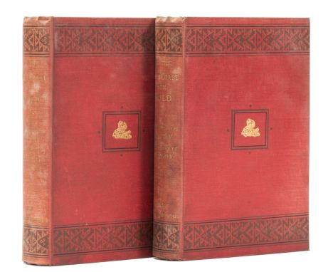
Lot 93
Bristol & Glastonbury.- T[homas] (J[ohn]) Different Plans for improving the Harbour of Bristol..., first edition, folding engraved plan with partial hand-colouring (soiled and laid down with very slight loss at fold), Bristol, J.Mills, 1800 § Glastonbury Canal. Prospectus, Particulars and Estimates, first edition, half-title, folding engraved map (offsetting), Wells, printed by B.Backhouse, 1826 § Compleat and Authentick History (A) of the Town and Abbey of Glastonbury...[with] An Accurate Account of the Properties and Uses of the Mineral Waters...By a Physician, second edition, engraved portrait of Henry VIII cut and mounted on verso of title, foxed, [Sherborne] printed for R.Goadby, and sold by W.Owen, at...London, [?1751] § Saunders (Samuel) A Description of the Curiosities of Glastonbury..., foxed, for J.Mathews, 1781, all later full or half calf or morocco, gilt, slightly rubbed, 8vo (4)⁂ All scarce pamphlets.

Lot 65
Polar.- Arctic.- Barrow (John) A Chronological History of Voyages into the Arctic Regions, first edition, lacking half-title, with large folding engraved map, 3 wood-engraved illustrations at end, some light browning, contemporary half diced russia, rubbed, joints split, 1818 § Payer (Julius) New Lands within the Arctic Circle: Narrative of the Discoveries of the Austrian Ship "Tegetthoff" in the years 1872-1874, 2 vol., first English edition, half-title in vol.2, chromolithographed frontispiece, 2 double-page maps, wood-engraved plates and illustrations, foxing, hinges weak, original pictorial blue cloth, gilt, rubbed, spines faded, 1876, 8vo (3)

Lot 108
Atlases.- Hall (Sidney) A New General Atlas, 53 hand-coloured double-page engraved maps mounted on stubs, title spotted, maps with occasional light foxing but generally clean, some creasing to index leaves, contemporary half morocco, rebacked preserving original backstrip, rubbed and scuffed, Longman, Brown, Green, and Longmans, [?1849]⁂ With the map of Australia showing only Western Australia, New South Wales, Australia Felix, and South Australia; Van Diemen's Land divided into 19 Police districts (counties); the United States with "Northwest Territory", "Indian Territory", New Mexico and Texas at the western edge; British North America with "Upper California", Oregon and Alaska as "Russian Territory".

Lot 140
New Forest.- Wise (John R.) The New Forest: Its History and its Scenery, Artist's edition, number 48 of 50 copies, presentation copy from the publisher's, 12 etched plates by Heywood Sumner, engraved illustrations by Walter Crane and a folding map, slight foxing mostly on plate guards, bookplate of H.M. Gilbert on front pastedown, original morocco-backed pictorial boards, slightly soiled, corners bumped, t.e.g., others uncut, 4to, Sotherans, 1883.
Lot 349
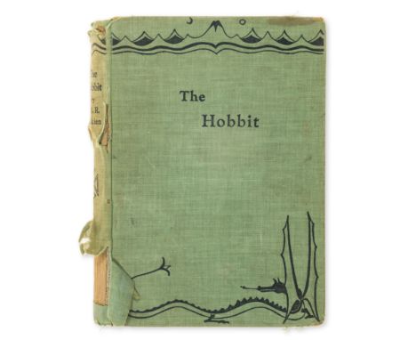
Tolkien (J.R.R.) The Hobbit, first edition, first impression, frontispiece, one plate, 8 illustrations including full-page, occasional marking, map endpapers printed in red & black, all by the author, lacking rear endpaper, front free endpaper browned and with small ink inscription, 2pp. advertisements, original green pictorial cloth, shelf lean, spine worn with significant loss, corners bumped, marking and soiling, rubbed, 8vo, 1937.
Lot 41
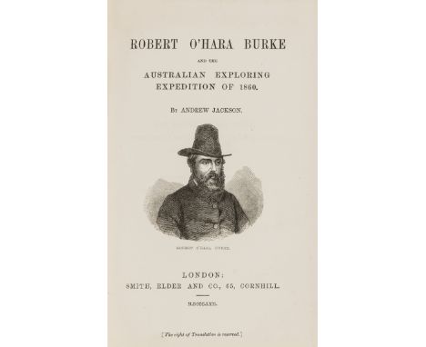
Australasia.- Australia.- Jackson (Andrew) Robert O'Hara Burke and the Australian Exploring Expedition of 1860, first edition, half-title, wood-engraved vignette portrait on title, folding map, 16pp. publishers' catalogue at end, very occasional light spotting, original blind-stamped green cloth, very slightly rubbed, corners bumped but a good copy, [Ferguson 10857; Wantrup 173], 8vo, 1862.** Account of the incompetent Burke and Wills expedition to cross Australia from Melbourne in the south to the Gulf of Carpentaria in the north, on which seven men died including the two leaders. "The single most outstanding disaster in the history of Australian exploration" Wantrup

Lot 45
Australasia.- Australia.- Maslen (T.J.) The Friend of Australia; or, a Plan for Exploring the Interior and for carrying on a Survey of the Whole Continent of Australia, second edition, folding map, 5 hand-coloured double-page lithographed plates mounted on stubs at end (3 views, partly-coloured plan for a town, and proposal for an Australian flag), foxing to title and first few leaves, original cloth, paper label on spine, rubbed, spine worn and chipped, old repairs to joints, [Ferguson 2145; Wantrup 117b; cf.Abbey Travel 574, first edition of 1830], 8vo, 1836.⁂ Scarce and eccentric work on the unknown Australian interior in accordance with the contemporary theory that the continent contained a vast inland sea, with proposals for an expedition using elephants, camels and craft for navigating the said sea.
Lot 147
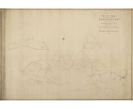
Somerset, Penselwood. Plan of the Property in the Parish of Penselwood in the County of Somerset Belonging to the Rt. Hon. Earl of Ilchester and Sir Henry Ainslie Hoare Bart., large manuscript estate map, joined together, linen-backed, slightly browned, 127 x 178cm., 1876.⁂ Map showing that the Manor of Penselwood was divided between the Earl of Ilchester and Sir Henry Hoare
Lot 144
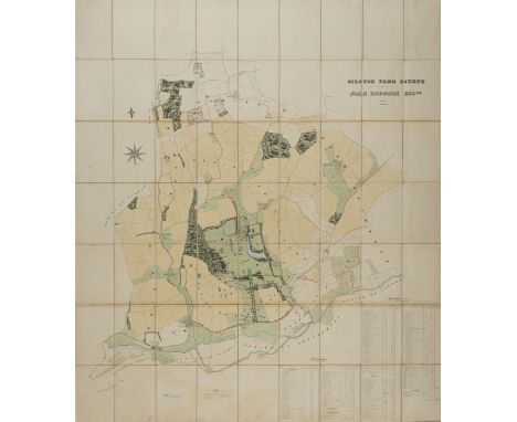
Hertfordshire Estate Map.- Adams (Charles F., surveyor, of Bartway, Hertfordshire) Gilston Park Estate, the Property of John Hodgson Esq., large folding hand-coloured manuscript estate map, reference key, mounted on linen, original black straight-grained morocco case, gilt, one side split, 185.5 x 155cm., 1851.⁂ John Hodgson was a wealthy shipbroker who purchased this extensive estate in 1850 and proceeded to alter it dramatically in his thirty year ownership. This map shows the area before the changes.
Lot 2
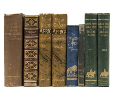
Africa.- Baker (Sir Samuel White) The Albert N'yanza, Great Basin of the Nile, and Explorations of the Nile Sources, 2 vol., engraved portrait frontispiece, 2 colour maps, one folding, tinted lithographed frontispiece and 11 wood-engraved plates, foxing at beginning and ends, 1866 § Livingstone (David and Charles) Narrative of an Expedition to the Zambesi and its Tributaries, folding wood-engraved frontispiece, plates and illustrations, folding map (tear to inner edge repaired), 32pp. publisher's catalogue at end, ink signature at head of title, 1865 Livingstone (David) Missionary Travels and Researches in South Africa, later issue, engraved portrait, wood-engraved plates, one folding, 2 folding maps at end, contemporary maroon morocco elaborately blocked in gilt, spine gilt, g.e., 1857 § Pinto (Maj. Serpa) How I Crossed Africa, 2 vol., folding colour map in pocket at end of vol.1, maps, plates and illustrations, some folding, rear hinges weak, 1881, first editions, all but the third original pictorial cloth, most gilt, rubbed, the first two a little damp-stained, some spines faded; and 2 others, Africa, 8vo (8)


Lot 145
After Christopher Saxton,'Salopiae Comitatus summa cum fide, cura et diligentia descriptionem haec tibi tabula refert', hand coloured engraved map of Shropshire,39 x 51 cm CONDITION REPORT: Removed from frame for identification but easily replaceableStuck to boardThe auctioneers do not believe this to be an original Saxton. Due to being stuck on board it is difficult to be certain.
-
109198 item(s)/page