We found 109182 price guide item(s) matching your search
There are 109182 lots that match your search criteria. Subscribe now to get instant access to the full price guide service.
Click here to subscribe- List
- Grid
-
109182 item(s)/page


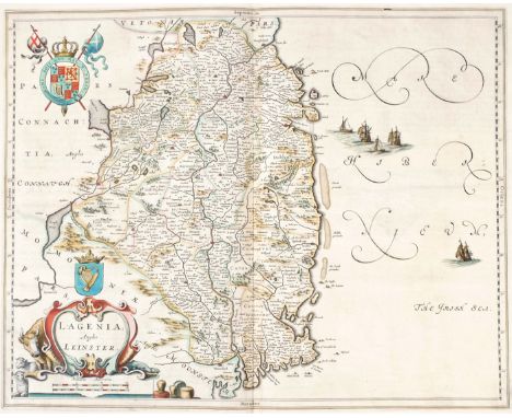
Lot 23
1740 A New Map of Ireland, by Herman Moll. A hand coloured engraved map of Ireland, divided into its Provinces, Counties and Baronies. Inset plans of the principal cities and harbours together with St. Patrick's Purgatory and the Giant's Causeway; by Herman Moll (1655-1732) From his extremely rare Atlas Minor published by Thomas & John Bowles (1740), mounted. 41 x 25in. (104.14 x 63½cm)


Lot 31
1759-1801 Maps of Ireland and Wexford and plans of the Principal Ports, Towns and Harbours of Ireland. Ireland divided in provinces and counties, from the best authorities, by Thomas Kitchin, from A New System of Modern Geography, 1786; A Map of the Southern part of the County of Wexford, from Memoirs of the different rebellions in Ireland, by Richard Musgrave, 1801; and Plans of the Principal Ports, Towns and Harbours of Ireland., hand -coloured engraving for Mr.Tindall's Continuation of Mr Rapin's History, 1759, mounted. (3) The largest 15¾ x 19¼in. (40.01 x 48.90cm)


Lot 13
1662 Map of Ireland by Joan Blaeu A hand-coloured, engraved map of Ireland, in the second state as published in Atlas Mayor, 1662, Latin edition, handwritten note to lower left margin, outside printed area, 'Caves discovered in 1833, 7 miles from Caher in Tipperary', unframed. Sheet size 20¾ x 24½in. (52.71 x 62.23cm)


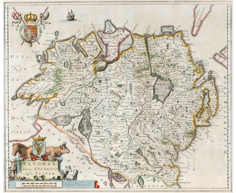
Lot 2
Early 17th century, map of Ulster by John Speed. John Speed 17th Century engraved and hand-coloured map of the province of Ulster with an inset oblique view of 'Enis Kelling fort'. The title, the Arms of Ireland and the scale displayed in decorative strapwork cartouches with the text 'Performed by John Speede and are to be solde by John Sudbury and George Humble in Popeshead Alley at London. Cum Privilegio. An 1610.'. Contained in a double sided frame. 14¾ x 20in. (37.47 x 50.80cm)


Lot 16
Late 17th century, map of Ireland A hand-coloured engraving, 'A Mapp of the Kingdome of Ireland', first published in 'Britannia, or a Geographical Description of the Kingdom of England, Scotland and Ireland', London,1673, four armorial cartouches including Richard Boyle, the Earl of Cork. 14½ x 15½in. (36.83 x 39.37cm)

Lot 36
1835 Chart of Waterford Harbour A hand-coloured engraved chart of Waterford Harbour, as surveyed by Samson Carter & Nobbett St. Leger, Engineers, for the Commissioners for Improving the Port, engraved by W. Keeble, London and printed by S. Hawkins, 1835. A very large map approx. 65cms x 100cms (25 1/2" x 39 1/2"), with attractive cartouche of The Hook Lighthouse. 28½ x 38½in. (72.39 x 97.79cm)
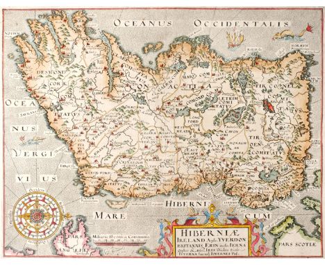
Lot 12
17th century, Hiberniae, Map of Ireland by William Camden and a city plan of Limerick. Hiberniae Ireland Anglis Yvrndon Britannis Erin incolis... A hand-coloured, engraved map of Ireland, oriented to the west, strapwork cartouche and compass rose, engraved by William Hole and published in the seventh edition of Camden's 'Britannia', 1610, no text verso; together with Limmericum. Limrich, town plan probably from Brittania Magna sive Angliae, Scotiae, Hiberniae & adjacentium insularum by Rutger Hermannides, 1661. both unframed. (2) the larger 12½ x 14¾in. (31¾ x 37.47cm)


Lot 19
17th and 18th century, Yorkshire, Schenk and Valk map and Greenvile Collins sea chart. Collins (Greenvile) Burlington Bay, Scarbrough & Hartlepoole, three hand-coloured sea charts on one sheet; together with Schenk and Valk, "Ducatus Eborensis par Orientalis, The Eastriding of Yorkshire." hand coloured engraved map with cartouche, shipping, heraldic devices. The larger 18¼ x 24¾in. (46.36 x 62.87cm)


Lot 26
1740 L' Hemisphere Septentrional pour voir plus distinctement les Terres Arctiques. By Guillaume de L'Isle; Ivan Kyrilov; Jean Cóvens; Corneille Mortier. Published by A Amsterdam: Chez Jean Co´vens et Corneille Mortier. Engraved map with original colouring, 460 x 460mm. The Northern Hemisphere from the North Pole to the Equator. The map clearly shows that there is no ‘Northwest passage’. Alaska is not completely mapped and there is a huge void between the American and Asian land masses. 18¾ x 20½in. (47.63 x 52.07cm)


Lot 495
BIBLE - ENGLISH - 18TH CENTURY, THE BOOK OF COMMON PRAYER, APOCRYPHA, NEW AND OLD TESTAMENTS AND PSALMS OF DAVID, Fol 91, [14], 712, [1], 160, [2], 248, 28, with twenty two engraved plates - each with eight images, and six maps by Joseph Moxon comprising 'Map of all the Earth', 'Paradise or the Garden of Eden', 'Israels peregrination or the forty years travels of the children of Israel', 'Jerusalem', 'Canan or the Land of Promise', 'Travels of St Paul', Psalms and testaments dated 1715, Psalms of David - Edinburgh, Evan Tyler, 1679, full tan calf with tooling and one clasp (1) (at fault)


Lot 482
SHROPSHIRE INTEREST: A Description of the County of Salop, from England Illustrated 1764, with map and two plates; PHILIPS (W), THE BREAKING OF THE SHROPSHIRE MERES, 24pp, EYTON (J), COLLECTION FOR THE COUNTY OF SALOP, three parts 1826, hand written, with folding plate of Shrewsbury tipped in; a hand written document on Lydbury North dated January 27th 1841; HUMPHREYS (J), URICONIUM, inscribed by the author, 1914; a lending book from F.G. Beddoes High Street Ironbridge dated 1891, an album of photographs of South Shropshire, mostly Ludlow and Much Wenlock, etc (Qty)

Lot 337
LATROBE (C), THE PEDESTRIAN, a summer ramble in the Tyrol, first edition, iv + 349, map frontis and vignette title, later full blue calf, London, Seeley, 1832; HALLAM (H), LETTERS FROM NORTH OF ITALY, two vols in one, later 3/4 green leather with marbled boards, London, Murray, 1819; BECKFORD (W), ITALY WITH SKETCHES OF SPAIN AND PADUA, Paris, 1834 (3)

Lot 198
THE PICTURESQUE BEAUTIES OF GREAT BRITAIN, 130 + ii, frontis, engraved half title, hand coloured frontis map and other engraved plates, George Vortue, 1830; BADHAM (REV C), THE HISTORY AND ANTIQUITIES OF ALL SAINTS CHURCH SUDBURY, frontis and five other plates, 1852; GIBBS (J), DESIGNS FOR GOTHIC ORNAMENTS AND FURNITURE, George Bell, 1853; DUGDALE (T), CURIOSITIES OF GREAT BRITAIN, ENGLAND AND WALES, engraved plates and maps, vol VII only; POPPEL (J), VENEDIG 24 AUSICHTEN, steel engraved plates, Munich 1846; KNIGHT AND RUMLEYS CRESTS, engraved armorial plates, Edmund Lodge, 1827 (6)
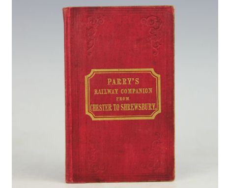
Lot 493
PARRY (E), THE RAILWAY COMPANION FROM CHESTER TO SHREWSBURY,..., the gigantic viaducts that span the vales of Llangollen and Ceiriog, with ancient border towns of Wrexham, Oswestry and Shrewsbury, first edition, with folding map, red cloth with gilt lettering, Chester, Thomas Catherall, 1849, in later hardboard cover, (a smart copy) (1)


![WYNDHAM (H), A GENTLEMANS TOUR THROUGH MONMOUTHSHIRE AND WALES, 2nd edition,viii + 218 + [6], engraved frontis, London, Evans](https://cdn.globalauctionplatform.com/ae176ff7-b105-47cb-835c-a6f50127a6bf/7651270e-e0de-4a21-f289-2821fdc2c222/468x382.jpg)
Lot 343
WYNDHAM (H), A GENTLEMANS TOUR THROUGH MONMOUTHSHIRE AND WALES, 2nd edition,viii + 218 + [6], engraved frontis, London, Evans, 1794; HEMINGWAY (J), PANORAMA OF THE BEAUTIES, CURIOSITIES AND ANTIQUITIES OF NORTH WALES, 2nd ed, viii + 314 + vi (index), frontis, three plates and folding map, full calf, London, Groombridge, 1835 (2)


Lot 376
JOHNSTON (A), ATLAS TO ALISON'S HISTORY OF EUROPE, new edition, engraved frontis with military signs and fortification notes, 106 hand coloured plans and maps of battles and sieges, folded linen backed map at end, re-backed green leather boards with gilt arms fro Elizabeth College Gurnsey, William Blackwood, 1850 (1)

Lot 500
BRASSEY (MRS), A VOYAGE IN THE SUNBEAM, 7th ed, with folding map, engraved plates and other illustrations, London, 1878; SUNSHINE AND STORM IN THE EAST OR CRUISES TO CYPRUS AND CONSTANTINOPLE, map and plates, London 1880; IN THE TRADES AND TROPICS AND THE ROARING FORTIES, map and plates, Longmans, 1885; THE LAST VOYAGE, Longmans, 1889; BRASSEY (EARL), THE "SUNBEAM" R.Y.S, London, John Murray, 1917; with, (5)
Lot 342
BARBER (T), BARBER'S PICTURESQUE ILLUSTRATIONS OF THE ISLE OF WIGHT, with forty plates and folding map, vignette of Cowes, green cloth, London, Simpkin, c1834; WANDERINGS IN THE ISLE OF WIGHT, first edition, vi + 186, title vignette and folding map, other decorations, London, Religious Tract Society, 1846 (2)

Lot 353
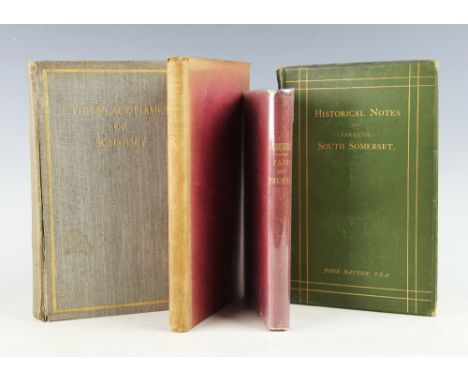
HILL (J), THE PLACE NAMES OF SOMERSET, subscription edition, No 45/300, illustrated, Bristol, 1914; BATTEN (J), TOPOGRAPHICAL COLLECTIONS RELATING TO THE EARLY HISTORY OF PARTS OF SOUTH SOMERSET, green cloth, London, 1894; HOLMES (T), THE HISTORY OF THE PARISH AND MANOR OF WOOKEY, first edition, frontis and double page map, Bristol, 1885; ROBINS (W), PADDINGTON PAST AND PRESENT, xv + 200, red cloth, Camden Town, 1853 (4)
-
109182 item(s)/page