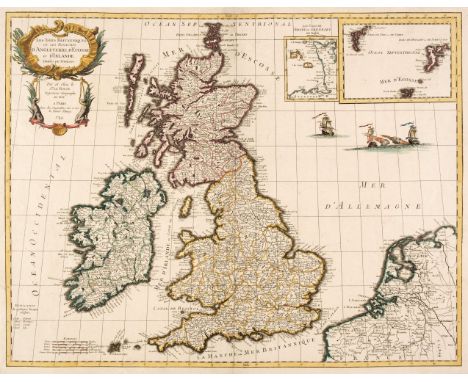

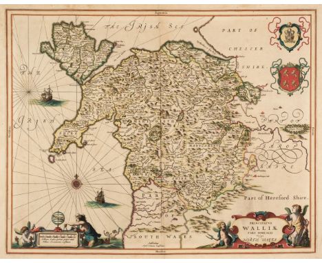
British Isles. Le Rouge (George Louis). Les Isles Britanniques ou les Royaumes d'Angleterre, d'Ecosse et d'Irlande Divisees par Provinces, Paris, 1744, engraved map with contemporary outline colouring and some later enhancement, inset maps of the Channel Islands and the Shetland and Faroe islands, central fold repaired on verso, 500 x 640 mm, together with Smith (Charles). Smith's New Map of England and Wales with Part of Scotland...., June 1806, corrected to 1811, engraved folding map with contemporary outline colouring, sectionalised and laid on linen, toned overall, slight dust soiling and staining, slight wear where old folds cross, 1150 x 940 mmQTY: (2)NOTE:The first map described. R. W. Shirley. Printed Maps of the British Isles, 1650 - 1750, Le Rouge 1, state 1 (only state recorded).
We found 109182 price guide item(s) matching your search
There are 109182 lots that match your search criteria. Subscribe now to get instant access to the full price guide service.
Click here to subscribe- List
- Grid
-
109182 item(s)/page
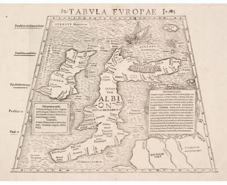
British Isles. Munster (Sebastian), Tabula Europae I, Basle, circa 1542, uncoloured woodblock Ptolemaic map on a trapezoidal projection, with two panels of text listing the ancient tribes of Britain and Ireland, margins strengthened on verso, 270 x 350 mm, Latin text within a 'classical' frame on verso, the woodcut designs which comprise the classical scenes within the frame are attributed to HolbeinQTY: (1)NOTE:R. W. Shirley, Early Printed Maps of the British Isles, 1477 - 1650, 32.
![British Isles. Ptolemy (Claudius). Prima Europe Tabula, Petrus de Turre, Rome [1490] engraved map on a trapezoidal projection](https://cdn.globalauctionplatform.com/e9dc0ac2-559f-4025-a874-ae7e01100a9c/16139c56-1140-4888-a9dd-ae7f00f6c0eb/468x382.jpg)
British Isles. Ptolemy (Claudius). Prima Europe Tabula, Petrus de Turre, Rome [1490] engraved map on a trapezoidal projection on two conjoined sheets, sparse wash colouring, later guard affixed to the central fold on the verso, slight dust soiling, 340 x 540 mm, no text on versoQTY: (1)NOTE:R. W. Shirley. Early Printed Maps of the British Isles, 1477 - 1650, number 6. Originally published in Rome in 1478 this is the second issue of number 2 and is one of the first obtainable maps of the British Isles.

Cambridgeshire. Speed (John), Cambridgeshire described with the devision of the Hundreds, the Townes situation, with the Armes of the Colleges of that famous Universiti, Henry Overton [1707 or later], hand-coloured engraved map, inset plan of Cambridge, occasional marginal closed tears, several repaired closed tears affecting the printed image, slight creasing, 380 x 515 mm, mounted, framed and glazedQTY: (1)
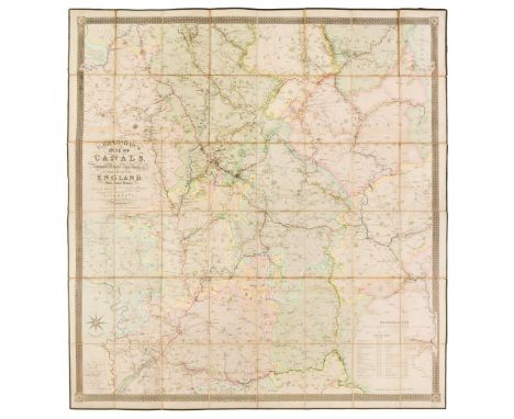
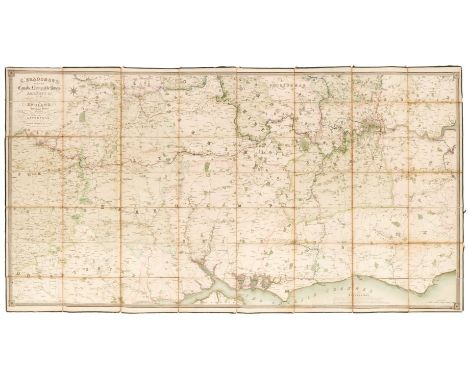
Canal Map. Bradshaw (G.), Map of Canals, Navigable Rivers, Railroads etc. of the Midland Counties of England from Actual Survey, shewing the heights of the Ponds on the Lines of Navigation from a Level 6ft. 10in. under the Old Dock Sill at Liverpool, from levels taken by Twyford & Wilson, Surveyors and Engineers, published G. Bradshaw, Manchester and sold by Mr Jas. Gardner, London, Feby. 12th. 1830, large engraved map with contemporary outline colouring, sectionalised and laid on linen, calligraphic title, table of explanation and compass rose, slight offsetting, edged in green silk, 1320 x 1240 mmQTY: (1)
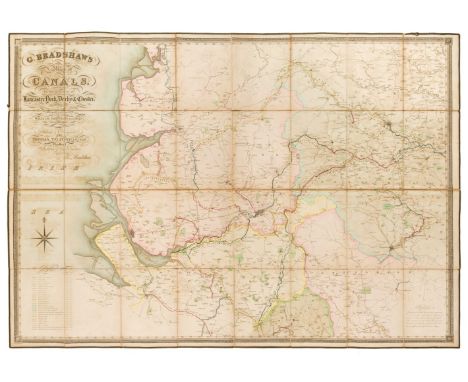
Canal Map. Bradshaw (G.), Map of Canals situated in the Counties of Lancaster, York, Derby & Chester; shewing the heights of their pools above the level of 6 ft. 10 in. under the Old Dock Sill at Liverpool. From Levels taken by William Johnson and Son, Manchester and dedicated by permission to Thomas Telford..., circa 1830, large engraved map with contemporary outline colouring, sectionalised and laid on linen, calligraphic cartouche, compass rose and tables of explanation and reference, some offsetting, edged in green silk, 890 x 1270 mm, marbled endpapersQTY: (1)
Canal Map. Bradshaw (G.), Map of the Canals, Navigable Rivers, Railways, &c. in the Southern Counties of England from Actual Survey Shewing the heights of the Pools and the Lines of Navigation, also the Planes on the Railways from a level of 6ft. 10in. under the Old Dock Sill at Liverpool, Dedicated by permission to Thomas Telford..., circa 1830, large engraved map on three conjoined sheets, with contemporary outline colouring, sectionalised and laid on linen, calligraphic cartouche, table of explanation and compass rose, slight offsetting, edged in green silk, 960 x 1865 mmQTY: (1)
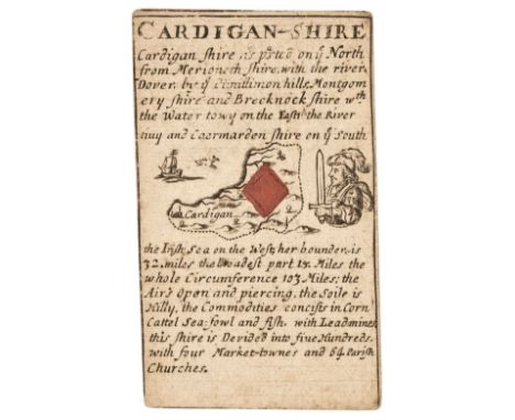
![Cardiganshire. Bill (John), Cardiganshire [1626], uncoloured engraved map, some staining to the lower margin but not affectin](https://cdn.globalauctionplatform.com/e9dc0ac2-559f-4025-a874-ae7e01100a9c/b3035eac-5bea-4ec0-ad7d-ae7f00f6c489/468x382.jpg)
Cardiganshire. Bill (John), Cardiganshire [1626], uncoloured engraved map, some staining to the lower margin but not affecting the printed image, 90 x 125 mm, English text on verso, together with Morris (Lewis). Cardigan Bay, Bar & Harbour in Cardiganshire Sept 29th 1748, hand-coloured map engraved by Nathaniel Hill, 180 x 245 mm, with Van den Keere (Pieter). Radnor, Breknok, Cardigan et Caermar. Den Descript [1617], uncoloured engraved map, 85 x 120 mm, Latin text on verso, plus Cowley (John). An Improved Map of Cardiganshire...., [1745], uncoloured engraved map, old folds, 140 x 160 mm, and Morden (Robert). Cardigan Shire [1701], hand-coloured engraved map, 165 x 210 mm, mounted, together with another 28 county, railway, touring and regional maps and occasional town plans, with examples by or after Cole & Roper, Langley, Dugdale, Kitchin, Jefferies, James, Creighton/Walker, Weller/Mackenzie, Dawson, Cary, Blackie & Son, Wincarnis, Ogden, Leigh, Darton, 'The Children's Friend', Hinton, Blome/Taylor, Seller and Mary Martha Rodwell, occasional duplicates, all small format, but various sizes and conditionQTY: (33)
![Cardiganshire. Redmayne (William), Cardigan-Shire, John Lenthall [1711 edition], engraved playing card map of Cardigan (Jack](https://cdn.globalauctionplatform.com/e9dc0ac2-559f-4025-a874-ae7e01100a9c/a7215866-6016-407f-ba96-ae7f00f6c5c1/468x382.jpg)
Cardiganshire. Redmayne (William), Cardigan-Shire, John Lenthall [1711 edition], engraved playing card map of Cardigan (Jack of diamonds), with a large uncoloured diamond placed over the county map, with English text above and below the map, 90 x 50 mm, together with Morden (Robert). Cardigan Sh: 2nd edition [1676], engraved playing card map of Cardigan (6 of spades), some dust soiling, 95 x 55 mmQTY: (2)NOTE:William Redmayne's playing cards were first published in 1676 as the 'Recreative Pastime by Cardplay; Geographical. Chronological and Historiographical of England and Wales...,'. This example - published by John Lenthall - was the third and final edition of these cards and can be identified by the decorative borders.Robert Morden’s set of playing cards was published in 1676 as a pack of fifty-four cards, including a title and explanation card. The Welsh and southwest counties of England are spades. There was a second edition published in the same year but they are considered comparatively rare. There was a third edition published in 1680 in partnership with Joseph Pask but these were in a bound volume, and finally in 1773 by H. Turpin, but this edition has no suit marks (to discourage gambling).
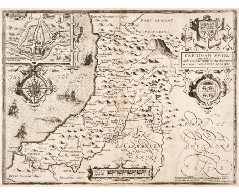
Cardiganshire. Speed (John), Cardigan Shyre Described with the due forme of the Shiretown as it was surveyed by J. S. John Sudbury & George Humble circa 1614, uncoloured engraved map, inset town plan of Cardigan, large strapwork cartouche, compass rose and milage scale, slight staining, two wormholes to the lower margin but not affecting the printed surface, 380 x 510 mm, English text on verso, together with Kitchin (Thomas). An Accurate Map of Cardigan Shire Drawn from an Actual Survey with Various Improvements..., circa 1765, engraved map with contemporary outline colouring and some later enhancement, lower margin trimmed to the neatline with a later paper extension, 345 x 530 mm, mounted, framed and glazedQTY: (2)

Cary (John). Cary's New and Correct English Atlas..., 1st edition 1787, advertisement, title page, dedication, list of subscribers and index, 31 (only of 47) engraved maps with contemporary outline colouring, each map with a page of descriptive text and tissue guard, index bound at rear, with an additional eight maps (Monmouth, Westmorland, Bedfordshire, Shropshire, Gloucestershire, Hampshire, Herefordshire & Huntingdonshire) loosely inserted, various editions and condition, later endpapers, 19th century half calf gilt, worn at extremities, 4toQTY: (1)NOTE:Lacking Cheshire, Cumberland, Devon, Dorset, Hampshire, Lancashire, Lincolnshire, Monmouthshire, Norfolk, Rutland, Suffolk, Westmorland, General map of Yorkshire, West Riding of Yorkshire and South Wales. Sold as a collection of maps, not subject to return.
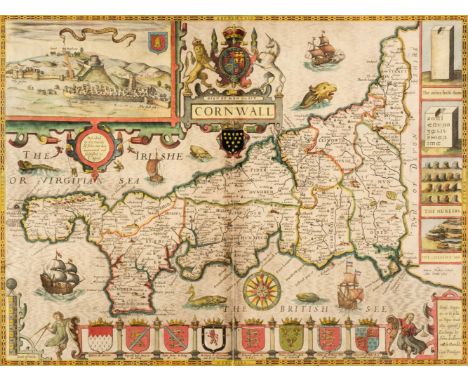
Cornwall. Speed (John & Norden John), Cornwall, John Sudbury & George Humble, circa 1627, hand-coloured engraved map, inset view of Launceston, large strapwork cartouche and compass rose, slight creasing, central fold partially split and crudely repaired on verso, slight staining and dust soiling, 380 x 510 mm, English text on verso, mounted, framed and double glazed, together with Devonshire with Excester Described and the Armes of such Nobles as have borne the titles of them, Thomas Bassett & Richard Chiswell [1676], hand-coloured engraved map, inset plan of Exeter, several repaired closed tears affecting the image, slight staining, torn with a very small area of loss to the lower right corner, 375 x 505 mm, mounted, framed and glazedQTY: (2)
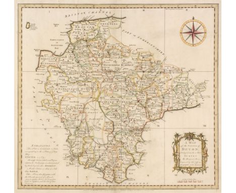
Devon. Donn (Benjamin), A Map of the County of Devon, abridged from the 12 sheet Survey, February 1st 1765, hand-coloured engraved map by Thomas Jefferys, decorative cartouche, compass rose and table of explanation, slight spotting, 505 x 545 mm, together with Bowen (Emanuel). An Accurate map of Devon Shire Divided into its Hundreds, Drawn from the best Authorities..., Carington Bowles & Robert Sayer, circa 1765, engraved map with contemporary outline colouring and some later enhancement, inset plan of Plymouth, long repaired closed tear affecting the printed surface, central fold strengthened on the verso, occasional marginal closed tears, slight staining and dust soiling, 535 x 680 mmQTY: (2)NOTE:Batten & Bennett, The Printed Maps of Devon, 45. Published as the key plate for Donn's large scale map of Devon but often found as a separate map.
![Durham. Speed (John), The Bishoprick of Durham, Thomas Bassett & Richard Chiswell, [1676], hand-coloured engraved map, in](https://cdn.globalauctionplatform.com/e9dc0ac2-559f-4025-a874-ae7e01100a9c/2fccd6e5-b941-40c5-a429-ae7f00f6c94a/468x382.jpg)
Durham. Speed (John), The Bishoprick of Durham, Thomas Bassett & Richard Chiswell, [1676], hand-coloured engraved map, inset town plan of Durham, small area of repair at the base of the central fold, very slight staining, light overall toning, 385 x 505 mm, English text on verso, together with Kitchin (Thomas). An Accurate Map of the County Palatine of Durham, Improved from the best Surveys & Intelligences and Divided into its Wards..., C. & J. Bowles and Robert Sayer [1765], engraved map with contemporary outline colouring, originally published in "The Large English Atlas", ornate uncolored allegorical cartouche, 525 x 690 mmQTY: (2)

East Indies. Mercator (Gerard & Hondius Jodocus), Insulae Indiae Orientalis Praecipuae In quibus Moluccae celeberrimae sunt, Amsterdam, circa 1620, engraved map with contemporary hand-colouring and some later enhancement, central fold strengthened and repaired on verso, two tape repairs to the left-hand margin on the verso, 345 x 475 mm, Latin text on versoQTY: (1)NOTE:A striking map of Southeast Asia and the Spice Islands. It clearly shows the influence of the Dutch East India Company, which extended from the Philippines to Timor, Sumatra and New Guinea. The annotation “Huc Franciscus Dra. Appulit” on the southern coast of Java, acknowledges Francis Drake's landing during his circumnavigation of the globe in 1577-80 and is one of the few maps to record this achievement.

Eastern Europe. Moll (Herman), To His Most Serene and August Majesty Peter Alexovitz, Absolute Lord of Russia &c. This Map of Moscovy, Poland, Little Tartary and ye Black Sea &c...., J. Bowles, P. Overton, T. Bowles and J. King, circa 1730, large engraved map on two conjoined sheets, contemporary outline colouring, inset maps of the Northern part of European Russia and the lower course of the Volga in the vicinity of Asov, old folds with slight wear, slight water staining to the lower margin, just affecting the printed image, 615 x 985 mm, framed and glazedQTY: (1)
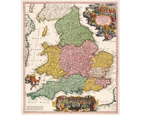
England & Wales. Homann (Johann Baptist), Magnae Britanniae pars meridionalis in qua regnum Angliae tam in septem antiqua Anglo-Saxonum Regna..., Nuremberg, circa 1725, engraved map with bright contemporary outline colouring with some later enhancement to the cartouche and historical vignette, 575 x 490 mm, together with Allard (Carol). Regni Angliae et Walliae Principatus tabula..., J. Covens & C. Mortier, Amsterdam, circa 1730, engraved map with contemporary outline colouring and some later enhancement to the cartouche 505 x 590 mmQTY: (2)NOTE:R. W. Shirley, Printed Maps of the British Isles, 1650 - 1750, Homann 3, state 1 [and] Allard 3, state 2.

Conway (William Martin). Climbing and Exploration in the Karakoram-Himalayas, 1st edition, London: T. Fisher Unwin, 1894, folding map, illustrations, advertisement leaf at end, some spotting to half title and endpapers, Liverpool College for Girls library ink stamp and presentation inscription to half title, original pictorial cloth, 8voQTY: (1)NOTE:Neate C103.
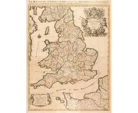
England & Wales. Jaillot (Alexis-Hubert & Sanson Nicolas), Le Royaume d'Angleterre distingué en ses Provinces..., Paris, [1693], large engraved map with contemporary hand colouring, large uncoloured decorative cartouche and mileage scale, toned overall, 780 x 585 mm, together with Tirion (Isaak). Nieuwe Kaart van de Eilanden van Groot Brittannien..., Amsterdam, circa 1770, engraved map with contemporary outline colouring, inset map of the Orkney and Shetland islands, 330 x 375 mm, with Chatelain (Henry Abraham), Carte du Gouvernement Militaire de l'Angleterre ou l'on Represente l'Etat des Officiers de Guerre et celui des Forces de Terre et de Mer, circa 1708, hand-coloured engraved map of the British Isles with a historical tableau on either side of the map and French text below, overall size 350 x 465 mm, mounted, plus another 14 maps similar, including examples by or after Albrizzi, Vertue, Muller, Nolin, Bickham and Du Laporte, various sizes and conditionQTY: (17)NOTE:The first described map. R. W. Shirley. Printed Maps of the British Isles 1650 - 1750, Jaillot 2, state 2.
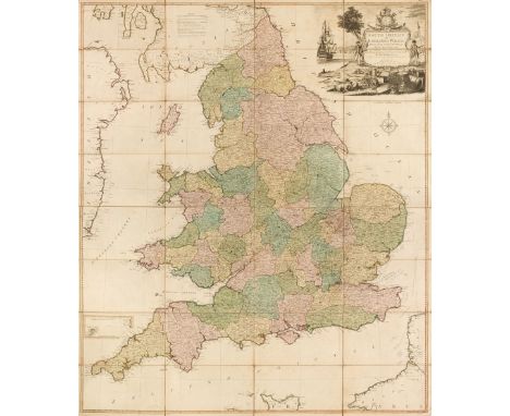
England & Wales. Kitchin (Thomas), South Britain or England & Wales, Drawn from several surveys &c. on a new projection corrected from astronomical observations & the places marked where the observat.ns were made, R. Sayer, 1787, engraved map with contemporary outline colouring, sectionalised and laid on linen, inset map of the Scilly Isles, large uncoloured decorative cartouche, the cartouche incorporates a coastal scene with a ship, a soldier and a sailor and a spread of artefacts representing British trades, including sheep, wheat and cannonballs, compass rose and table of remarks, slight dust soiling and spotting, 1275 x 1090 mm, together with Stanford (G. publisher). Stanford's Map of the New Probate Districts of England and Wales...., 1858, lithographic map with contemporary outline colouring, sectionalised and laid on linen, slight dust soiling and staining, 950 x 805 mm, contained in a publisher's red cloth slipcase with printed label to the upper cover, some wear to the extremities, with Laurie (Richard Holmes). England, circa 1870, engraved map with contemporary outline colouring, sectionalised and laid on linen, inset maps of Scilly Isles and the Channel islands, 800 x 630 mm, marbled endpapers, bound in contemporary green cloth boards, very slight wear to extremities, plus Geike (Sir Archibald). Geological Map of England & Wales..., John Bartholomew & Co. 1897, colour lithographic map, sectionalised and laid on linen, inset tables of explanation, 1020 x 840 mm, bound with a 28-page pamphlet of explanatory text, bound in contemporary blue cloth gilt, boards water stained and warped, and Philip (George and Son, publishers). Philip's Cyclist's Map of England and Wales, circa 1890, colour printed lithographic folding map, laid on linen, inset map of the Environs of London, 805 x 610 mm, some spotting and creasing, bound in contemporary blue boards, worn at extremitiesQTY: (5)
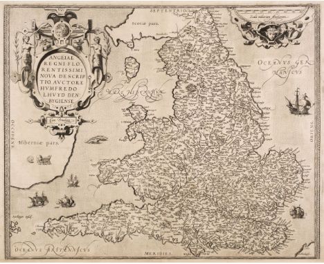
England & Wales. Ortelius (Abraham & Lhuyd Humphrey), Angliae Regni Florentissimi nova descriptio auctore Humfredo Lhuyd Denbygiense, Antwerp [1573], uncoloured engraved map, lower horizontal margin trimmed to the neatline, professionally repaired and margin extended, 390 x 475 mm, Latin text on versoQTY: (1)NOTE:Marcel Van den Broecke. Ortelius Atlas Maps, 19, 1st state. R. W. Shirley. Early Printed Maps of the British Isles, 98.
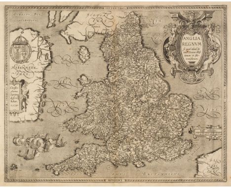
England & Wales. Ortelius (Abraham & Saxton Christopher), Anglia Regnum si quod aliud in toto Oceano ditissimum et florentissimum, Jan Baptist Vrients, Antwerp [1603], uncoloured map engraved by Pieter van den Keere, large decorative cartouche and strapwork mileage scale, additional strapwork cartouche paying tribute to Christopher Saxton and a large maritime vignette commemorating the attack of the Spanish Armada to lower-left, large margins, central fold and lower margin professionally restored on verso, 385 x 485 mm, Latin text on versoQTY: (1)NOTE:R. W. Shirley, Early Printed Maps of the British Isles 1477 - 1650, 258. Marcel Van den Broecke, Ortelius Atlas Maps, 20.

Europe and Mediterranean Islands. A collection of 25 maps, 16th - 20th century, engraved and lithographic maps of Europe, Malta, Cyprus, Rhodes and Corsica, including examples by or after Van der Aa, De Fer, Munster, Malte-Brun, Coronelli, Chatelain, Stanford, Bartholomew and Mallet, some duplicates, together with an early 20th-century souvenir handkerchief displaying a map of Europe, 455 x 590 mm and four topographical and genre engravings from 'The Graphic' and other publications, various sizes and conditionQTY: (30)
Europe. Andriveau (J. & Goujon J.). Carte Physique et Politique de l'Europe, Paris, 1843, large engraved map with contemporary outline colouring on two conjoined sheets, 975 x 1285 mm, together with De Vaugondy (Robert). L'Europe Divisée en ses Principaux Etats..., Paris, 1751, engraved map with contemporary outline colouring and some later enhancement to the cartouche and mileage scale, central fold split at the base and partially repaired on verso, 485 x 580 mm, with Philip (George & Son, publishers). Europe, circa 1860, lithographic map with contemporary outline colouring, one short marginal closed tear, 515 x 620 mm, plus Bartholomew (J. publisher). Europe, Edinburgh, circa 1880, colour printed photolithographic map, 430 x 550 mmQTY: (4)
Cruchley (G.F. publisher.) Cruchley's General Atlas, for the use of Schools and Private Tuition...., 1st edition, 1843, calligraphic title page with contents list, 31 (complete as list), double-page engraved maps with contemporary outline colouring, map of the Americas with a short closed tear just affecting the printed image, specimen plate and two pages of publisher's advertisements bound at rear, ownership sticker of Brigadier F. R. W. Jameson D. S. O., M. C. to front endpaper, slight spotting to endpapers and pastedowns, upper hinge cracked and partially split, contemporary half morocco with gilt title to the upper siding, spine partially lacking, heavily worn and rubbed, folioQTY: (1)
![Flint & Denbigh. Speed (John), Denbighshire [and] Flint-Shire, both published by John Sudbury & George Humble, circa](https://cdn.globalauctionplatform.com/e9dc0ac2-559f-4025-a874-ae7e01100a9c/301cefd6-540e-4a5b-b6e3-ae7f00f6d3ed/468x382.jpg)
Flint & Denbigh. Speed (John), Denbighshire [and] Flint-Shire, both published by John Sudbury & George Humble, circa 1627, two hand-coloured engraved maps, both with inset town plans, each approximately 380 x 510 mm, English text on verso, both framed and double-glazed, together with Morden (Robert). Radnorshire, circa 1701, hand-coloured engraved map, old folds, 160 x 210 mm, mounted, framed and glazedQTY: (3)
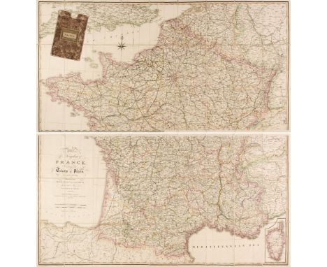
France. Wyld (James), Wyld, Map of the Kingdom of France according to the Treaty of Paris, November 20th 1815, Divided into Departments and Districts from the Map of M. Cassini de Theury, April 4th 1825, large engraved map with contemporary outline colouring, sectionalised and laid on linen, on two sheets, inset map of Corsica, calligraphic cartouche and compass rose, each sheet 615 x 1180 mm, contained in a contemporary marbled card slipcase with a publisher's printed label to the upper cover and spineQTY: (1)NOTE:A fine example of Wyld's reduction of Cassini's monumental map of France. After Napolean's defeat in 1815, France underwent the Bourbon Restoration with Louis XVIII being restored to the throne, which would last until the July revolution of 1830.

Ireland. Rocque (John), A Map of the Kingdom of Ireland..., Robert Sayer, circa 1773, large engraved map with contemporary outline colouring, four sheets conjoined into two pairs, uncoloured decorative cartouche, inset map of 'The Sea Coasts of Great Britain and Ireland', old folds, very occ. small marginal closed tears, slight staining and offsetting, overall size 1245 x 975 mm, together with Weller (Edward). Ireland, circa 1890, large colour lithographic map, old folds, 830 x 640 mm, with Society for the Diffusion of Useful Knowledge (publishers). Dublin & The Environs of London, circa 1860, two engraved maps with contemporary outline colouring, each with a blind stamp to the lower-left corner, each approximately 320 x 405 mm, plus Kitchin (Thomas). The Province of Leinster, one of the four into which Ireland is Divided by Geographers, circa 1760, hand-coloured engraved map, originally published in 'The London Magazine', old folds, 235 x 175 mm, with Arbuckle Bros. Coffee Co. (publishers). Untitled decorative map of Ireland, circa 1900, chromolithograph showing a map of Ireland and a view of Innisfallen in Killarney with promotional/advertising text to the verso, 75 x 125 mmQTY: (6)
![Ireland. Speed (John), The Province of Mounster, 1st edition, John Sudbury & George Humble [1611], uncoloured engraved ma](https://cdn.globalauctionplatform.com/e9dc0ac2-559f-4025-a874-ae7e01100a9c/f07fb0da-37e3-4c63-9868-ae7f00f6d706/468x382.jpg)
Ireland. Speed (John), The Province of Mounster, 1st edition, John Sudbury & George Humble [1611], uncoloured engraved map, inset town plans of Limerick and Cork, slight overall toning, short split at the base of the central fold, old ink library stamp to the upper right corner, 390 x 515 mm, English text on versoQTY: (1)

Ireland. Speed (John), The Province of Ulster, John Sudbury & George Humble, circa 1627, hand-coloured engraved map, inset view of Enis Kelling Fort, occasional marginal repaired closed teras, central fold partially split and frayed, some staining and dust soiling, torn with areas of loss to the upper corners, skillfully restored, narrow margins, 375 x 505 mm, mounted, framed and glazed, together with The Province of Mounster, John Sudbury & George Humble, circa 1627, hand-coloured engraved map, inset town plans of Cork and Limerick, central fold split with some fraying, some vertical creasing, several repaired marginal closed tears, slight surface abrasion, narrow margins, 385 x 505 mm, mounted, framed and glazedQTY: (2)

Italy. Moll (Herman), A New Map of Italy, Distinguishing all the Sovereignties in it, whether States, Kingdoms, Dutchies, Principalities, Republicks &c. With the Post Roads..., D. Midwinter, T. Bowles and P. Overton, circa 1730, engraved map with contemporary outline colouring, large uncoloured cartouche, inset views of Mount Etna, Mount Vesuvius and the Cataract of Air on Mount Aeolius, old folds, some creasing, slight staining, several repaired marginal closed tears, a few short closed tears affecting the image, small areas of loss along the left-hand vertical fold, crudely repaired on verso, 605 x 1025 mm, framed and glazedQTY: (1)

Lake District. Clarke (James), Six maps of the Lake District, A Map of the Lake of Ullswater and its Environs, A Map of the Southern Part of the Lake Winandermere (sic) and its Environs, A Map of Broadwater and its Environs, A Map of the Roads Lakes &c between Keswick and Ambleside, A Map of the Roads, Waters &c. between Penrith and Keswick [and] A Map of the Roads between Penrith and Ullswater, circa 1789, together six uncoloured engraved maps, laid on linen, old folds, some creasing and repaired closed tears, slight dust soiling and staining, each approximately 460 x 1000 mmQTY: (6)NOTE:Originally published in James Clarke's A Survey of the Lakes of Cumberland, Westmorland, and Lancashire.

Lewis (Samuel & Co. publisher). Lewis's Atlas comprising the Counties of Ireland and a General Map of the Kingdom, 1846, calligraphic title with an engraved allegorical vignette, contents list, folding map of Ireland, 32 (complete as list) engraved county maps, all with bright contemporary outline colouring, contemporary cloth gilt, slight staining to boards, 4to, together with another 2 uncoloured copies, but both with defective general maps of Ireland and some staining, contemporary cloth boards, stained and worn, 4toQTY: (3)

Lewis (Samuel). Atlas to the Topographical Dictionary of England and Wales, 1848, lacking title and preliminaries, folding map of England and Wales and Yorkshire and 29 (only) uncoloured engraved English and Welsh county maps, but with the folding map of London, text block shaken and loose and partially disbound, hinges and joints weak and cracked, contemporary cloth, lacking spine, rubbed and worn, slim 4to, together with A Topographical Dictionary of Scotland..., 1847, title page, 6 large folding engraved maps with contemporary outline colouring, some repairs to old folds on verso, contemporary blind-stamped cloth gilt, faded with some wear and fraying to the spine, 4toQTY: (2)NOTE:Sold as a collection of maps, not subject to return.
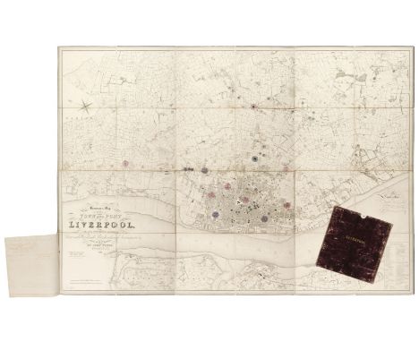
Liverpool. Bennison (Jonathan), Bennison's Map of the Town and Port of Liverpool with their Environs including Seacombe, Woodside, Birkenhead, Tranmere &c. from actual survey, Liverpool, 1846, large map, engraved by John Dower, with contemporary outline colouring, additional watercolour circles marking the locations of water tanks and reservoirs, with a manuscript explanation key, sectionalised and laid on linen, calligraphic cartouche, compass rose and table of reference, slight offsetting, three manuscript sheets of paper giving details of the water tanks and reservoirs stitched to the lower left margin, 1280 x 1780 mm, contained in a contemporary morocco gilt slipcase, case worn and rubbedQTY: (1)NOTE:Originally published in 1835, this later example has been utilised by the Liverpool waterworks company to map and record the location of the water system and reservoirs.

London. Bacon (G. W.), New Map of London Divided into Half Mile Squares & Circles, Cassell, Petter & Galpin, circa 1890, uncoloured lithographic map, sectionalised and laid on linen, 725 x 1000 mm, marbled endpaper, bound in contemporary half morocco gilt boards, some wear to extremities, small hole in spine, board size 260 x 205 mm, together with, Cary (John). Cary's New Plan of London and its Vicinity..., Shewing the Limits of the Two-Penny Post Delivery...., 1837, engraved map with contemporary outline colouring, sectionalised and laid on linen, dust-soiled and stained, slight wear where the old folds cross, one small biro annotation to the map, 735 x 180 mm, marbled endpapers, with Mogg (F. S.). Modern London and its Environs drawn from the Latest Surveys, 1853, uncoloured engraved map, old folds, laid on linen, slight dust-soiling, 520 x 685 mm, bound with a 30-page index to the streets and squares, contemporary cloth boards with orange and black publisher's title label to the upper cover, board size 155 x 110 mmQTY: (3)
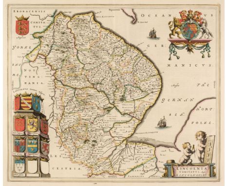
Maps. A collection of approximately 105 maps, 17th - 19th century, British county maps and road maps, including Blaeu (Johannes). Lincolnia comitatus Anglis Lincoln-Shire, Amsterdam, circa 1648, engraved map with contemporary outline colouring, some creasing, 420 x 500 mm, Dutch text on verso, together with Jansson (Jan). Comitatus Nottinghamiensis sive Nottinghamshire, Amsterdam circa 1648, engraved map with contemporary outline colouring, toned overall, 380 x 480 mm French text on verso, with Bowen (Emanuel). An Accurate Map of the County of Derby Divided into Hundreds..., R. Sayer, Carington Bowles & R. Wilkinson, circa 1785, engraved map with contemporary outline colouring, slight creasing, toned overall, mount stained, 700 x 540 mm, plus a small collection of maps of Hereford, Monmouth & Brecon, including examples by or after Teesdale, Cary, Morden, Moule, Reuben Ramble, Badeslade & Toms, Owen & Bowen, Philips, Seller/Grose, Rocque, Kitchin and Pigot, occasional duplicates, various sizes and condition, with road maps by Gardner, Owen & Bowen and The Gentleman's Magazine, and 7 county maps originally published in Thomas Kitchin's 'Pocket Atlas', plus the frontispiece map of the British Isles from the Saxton/Hole edition of the 'Britannia', early hand colouring but trimmed to the neatline and laid on later paper, 265 x 165 mm QTY: (approx. 105)
![Merian (Matthaus the younger). Abbildung der Statt und Rivier von Rochester, Chetham etc. [on sheet with] Prospect detz Enlan](https://cdn.globalauctionplatform.com/e9dc0ac2-559f-4025-a874-ae7e01100a9c/725c3433-bc90-419c-97ce-ae7f00f6e0a9/468x382.jpg)
Merian (Matthaus the younger). Abbildung der Statt und Rivier von Rochester, Chetham etc. [on sheet with] Prospect detz Enlands Shepey und der Bestung Shirnalse...., circa 1680, two uncoloured engravings on one sheet (as published), old folds, overall size 300 x 370 mm, together with Bellin (Jacques Nicolas). Carte Réduite des Isles Britanniques, Drésée au Depost des Carrtes, Plans et Journaux de Marine..., Paris, 1757, uncoloured engraved map of the British Isles with the depot de la Marine stamp to the lower right corner, some water staining, occasional rust spots, 890 x 560 mm, with Albrizzi (Girolamo). Reges Angliae Inchiito ac Potentiss Jacobo pº eius nominis Angliae Franciae et Hiberniae VI hoc noie Scotiae regi D. D. D. Venice [1614 or later], uncoloured engraved 'family tree' of the British monarchy, inset vignette of Nonsuch Palace, some browning to the central fold, occasional marginal closed tears, 545 x 385 mm, Latin text on verso, plus Chatelain (Henry Abraham). Carte du Gouvernement Écclesiastique D'Angleterre..., circa 1720, hand-coloured engravings set above French text, 355 x 455 mm, with another three engravings and maps similar, various sizes and condition QTY: (7)NOTE:The first described item illustrates the Dutch fleet's infamous raid on the anchored English fleet in Rochester in 1667, which resulted in five English ships being burnt.

Middlesex. Robinson (William publisher), Map of the Parish of Edmonton, County of Middlesex, showing the Allotments in the Common Fields & Common Marshes as divided by Act of Parliament in the Years 1801 & 1802, 1819, hand-coloured engraved map, old folds, vertical margins trimmed and with later extensions, small areas of repair on verso where old folds cross, backed with archival tissue, 495 x 690 mm, together with Betts (J. C.). Underground Railways of London, Waterlow & Sons, Watford, circa 1925, colour lithographic map, two tables of reference to Buildings and Railways, old folds, some wear where old folds cross, some dust soiling and marginal fraying and creasing, 350 x 440 mm, theatre plan and advertisements printed on the verso, with Norden (John & Kip W.). Middlesex Olima Trinobantibus Habitat, circa 1637, hand-coloured engraved map, narrow margins and laid on later paper, slight spotting, 280 x 340 mm, plus Walker (W. C.). The True Plott and Description of the lands belonging to ye Mannors of Pembroke..., in the Parishes of Tottenham and Edmonton..., T. T. Barrow, 1823, hand-coloured engraved map, old folds, repaired closed tears affecting the printed image, 420 x 690 mm, and Cole (B.). A New and Accurate Survey of the Parishes of St. Andrews Holborn..., circa 1730, hand-coloured ward plan, 375 x 230 mm, QTY: (5)

North Wales. Blome (Richard), A Generall Mapp of North Wales wherein are ye Countys of Montgomy, Merioneth, Denbigh, Flint, Carnarvan & Ye Isle of Anglesey, 1673, uncoloured engraved map, old folds, slight creasing, 340 x 455 mm, together with Mercator (Gerard & Hondius Henricus). Westmorlandia, Lancastria, Cestria, Caernarvan, Denbigh, Flint, Merionidh, Montgomery, Salopia cum insulin Mania et Anglesey, circa 1610, uncoloured engraved map, some worming to the lower margin just affecting the printed image, 360 x 410 mm, German text on verso, with Evans (John). To Sir Watkin Williams Wynn, Bart. This Map of North Wales is Respectfully Inscribed [1797], a reduction of John Evans's large nine-sheet wall map with contemporary outline colouring, engraved by Robert Baugh, frayed with some loss to the strapwork borders along both the horizontal margins, borders repaired and extended, old folds, central fold repaired and strengthened on verso, 615 x 745 mm, with another 20 engraved and lithographic maps of North Wales, by or after Stockdale, Cary, Arrowsmith, Duncan, J & C Walker, Bacon, A & C Black, George Philip & Son, Teesdale, Fisher, Collins, Morden and Mason & Payne, occasional duplicates, various sizes and condition QTY: (23)
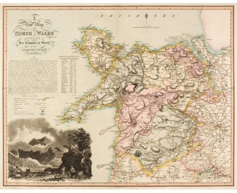
North Wales. Dix (Thomas & Darton William), A New Map of North Wales divided into its Six Counties or Shires, 1820 - 22, an engraved map with contemporary hand-colouring, calligraphic cartouche, table of explanation, list of market towns and a large uncoloured vignette of Snowden, 545 x 690 mm, together with Saxton (Christopher & Lea Philip). Radnor, Breknoke, Cardigan and Carmarthen Shires, Discribed by C. S. Corrected and Amended with many Additions by P. Lea, George Willdey at the Great Toy Sjop..., circa 1730, engraved map with contemporary outline colouring, inset town plans of Carmarthen, Brecknock, Radnor and Cardigan, some rust scaring affecting the upper strapwork margin, old manuscript title on verso causing slight show through but not affecting the printed image, 370 x 480 mm, with Bowen (Emanuel). A Map of the Six Counties of North Wales Divided into their respective Hundreds..., Robert Sayer, John Bennett J & C Bowles, circa 1794, engraved map with contemporary outline colouring, originally published in 'The Royal English Atlas', 410 x 515 mm, plus Carington Bowles (publisher). An Accurate Map of North Wales Divided into its Counties; viz. Carnarvonshire, Flintshire, Denbeighshire, Merionytheshire, Montgomeryshire with the Isle of Anglesey..., circa 1780, engraved map with contemporary outline colouring and some later enhancement to the cartouche, originally published in 'The Large English Atlas' (4th state), old folds, some creasing, dust-soiled and stained, occasional marginal repaired closed tears, central fold strengthened on verso, 520 x 675 mm, QTY: (4)
North Wales. Jansson (Jan), Principatus Walliae pars Borealis vulgo North Wales, Amsterdam, circa 1648, engraved map with contemporary outline colouring, decorative cartouche and mileage scale, compass rose and numerous rhumb lines, slight staining, but largely confined to the margins, 405 x 515 mm, Latin text on verso, together with Bowen (Emanuel). A Map of the Six Counties of North Wales Divided into their respective Hundreds..., H. Parker, J & C Bowles, H, Overton, J. Ryall, R. Sayer and T. Kitchin, circa 1762, engraved map with contemporary outline colouring, originally published in 'The Royal English Atlas', one small rust stain, 410 x 515 mm, with Schenk (P. & Valk G.). Principatus Walliae pars Borealis vulgo North Wales, Amsterdam [1714 - 24], engraved map with contemporary outline colouring, decorative cartouche and mileage scale, compass rose and numerous rhumb lines, 405 x 515 mm, no text on verso, plus Mercator (Gerard & Hondius Henricus). Westmorlandia, Lancastria, Cestria, Caernarvan, Denbigh, Flint, Merionidh, Montgomery, Salopia cum insulin Mania et Anglesey, circa 1630, uncoloured engraved map, 360 x 415 mm, Latin text on versoQTY: (4)

Nottinghamshire. Speed (John), The Countie of Nottingham described, The Shire Townes situation and the Earls thereof Observed, circa 1627, uncoloured engraved map, inset town plan of Nottingham, some dust soiling and staining, central fold partially split and repaired on verso, 385 x 505 mm, English text on verso, together with another copy similar, mounted, framed and double-glazed, with, Bedfordshire and the Situation of Bedford described..., George Humble, circa 1627, uncoloured engraved map, inset town plan of Bedford, slight creasing, slight browning to the central fold, one rust hole affecting the printed image, 385 x 510 mm, plus Jansson (Jan). Somersettensis comitatus Somerset Shire, Amsterdam, circa 1650, engraved map with contemporary outline colouring, two small holes affecting the printed image, 375 x 495 mm, French text on verso, mounted, framed and double-glazed, and Blaeu (Johannes). Somersettensis Comitatus Somerset Shire, Amsterdam, circa 1645, hand-coloured engraved map, 375 x 495 mm, Latin text on verso, mounted, framed and double glazed, with Bowen (Emanuel). An Accurate Map of Northampton Shire Divided into its Hundreds..., J. Hinton, 1752, engraved map with contemporary outline colouring, originally published in 'The Large English Atlas', 710 x 535 mm, plus another 18 maps (many of Northamptonshire), including examples by or after Morden, Blaeu, Speed, Archer, Kitchin, Lewis, Cary, Owen & Bowen and Schenk & Valk, occasional duplicates, various sizes and conditionQTY: (24)

Ogilby (John). The Road from the City of Salisbury com. Wilts to Campden com Gloc., The Road from London to St. Neots in com. Hunt. continued to Oakeham in com. Rutland, The Continuation of ye Roads from London to Aberistwith Plate ye Second commencing at Islip com. Oxford & Extending to Bramyard com. Hereford [and] The Continuation of the Road from London to Bristol ]1675 - 98], together four hand-coloured engraved strip road maps, some marginal repaired tears and strengthening to the central folds, the last map described backed with later paper, each approximately 345 x 450 mmQTY: (4)NOTE:Plate numbers 2, 45, 85 & 11.
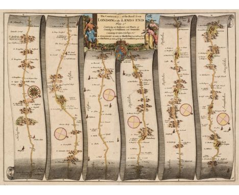
Ogilby (John). The Continuation of the Road from London to the Lands End Plate 2d. commencing at Andover com. Hants & extending to Crookhorn com. Somerset, The Road from London to Weymouth com. Dorset [and] The Road from London to Pool in the Count. Dorset, circa 1676, together three hand-coloured engraved strip road maps, the first described map with professional repairs to the central fold, each approximately 320 x 445 mmQTY: (3)NOTE:Sheet numbers 26, 53 & 97.

Oxfordshire. Speed (John), Oxfordshire described with ye Citie and the Armes of the Colledges of ye famous University, John Sudbury & George Humble, circa 1614, hand-coloured engraved map, an inset town plan of Oxford, eighteen heraldic shields to margins, slight creasing and toning, central fold partially strengthened on the verso, 385 x 525 mm, English text on verso, together with Morden (Robert). Oxford Shire [1695 or later], hand-coloured engraved map, 425 x 365 mm, with Moule (Thomas). City and University of Oxford, circa 1845, hand-coloured engraved city plan, slight mount staining, 245 x 190 mm, plus Cole (G. & Roper J.). Oxford, Vernor, Hood & Sharpe, Feby. 1st 1808, hand-coloured engraved city plan, slight marginal spotting, 195 x 250 mm, and Morden (Robert). Oxfordshire, circa 1701, hand-coloured engraved map, old folds, 215 x 160 mmQTY: (5)

Roman Empire. Moll (Herman), An Historical Map of the Roman Empire and the neighbouring Barbarous Nations to the Year of our Lord Four Hundred when the Empire began to be rent with foreign invasions..., T. & J. Bowles, Philip Overton and John King, 1709 [ but circa 1730], large engraved map with contemporary outline colouring on two conjoined sheets, duplicate cartouche in Latin, two inset maps of the East and Western hemispheres, old folds, very slight creasing and staining, 485 x 1170 mm, framed and glazedQTY: (1)NOTE:An extensively annotated map, crammed with historical notes and observations. The map is based upon a similar example by Guillaume De l'Isle, who is credited in the title cartouche.

Scotland. De Vaugondy (Robert), Le Royaume D'Ecosse divisé en Shires ou Comtés, 1751, hand-coloured engraved map, 490 x 575 mm, together with Jansson (Jan). Norfolciae Descriptio. The Description of Norfolk, Amsterdam, circa 1650, engraved map with contemporary outline colouring, slight offsetting and text show through, 385 x 490 mm, German text on verso, with Senex (John, Halley Edmond & Cutler Nathaniel). Milford Haven Accurately Surveyed (2 copies) & The Severn or Channel of Bristol, circa 1730, together three uncoloured sea charts, originally published in ' Atlas Maritimus et Commercialis', slight toning, some marginal fraying, each approximately 505 x 600 mmQTY: (5)

Scotland. Mercator (Gerard), Scotia Regnum, circa 1610, hand-coloured engraved map, large strapwork cartouche, some marginal fraying and closed tears but not affecting the printed image, toned overall, 355 x 405 mm, French text on verso, together with Rapkin (J.). Glasgow, John Tallis and Company, circa 1850, hand-coloured city plan, one repaired marginal closed tear affecting the printed image, slight mount staining, 360 x 480 mmQTY: (2)

Scotland. Speed (John), The Kingdome of Scotland, John Sudbury & George Humble, circa 1627, hand-coloured engraved 'carte-a-figures' map, inset map of the Orkney islands, four costumed figures to the vertical margins, slight creasing, central fold frayed and repaired, some staining, narrow borders with the mount partially obscuring the strapwork margins, 370 x 505 mm, mounted, framed and glazedQTY: (1)

Sea Charts. Mortier (Pierre), 2me Carte Particuliere des Costes de Normandie Contenant les Costes du Cotentin..., les Isles de Jerzey, Grenezey, Cers, & Aurigny avec les Isles de Brehat..., Amsterdam, circa 1693, large coloured engraved sea chart of the Channel Islands and the North-west coast of France, very slight toning to the central fold, 595 x 810 mm, together with Van Keulen (Joannes & Gerard). Nieuwe Zeekaart van t' derde Gedeelte van t' Canaal Tusschen Engeland en Vrankryk = Nouvelle Carte Marine Pour la Troisjeme Partie de la Manche Entre Engleterre et France = the New Sea Map of the Third Partie of the Chanell Betext England en France, Amsterdam, circa 1728, hand-coloured engraved sea chart of South west England, The Scilly Isles, and North west France, titles in Dutch, French and English, 500 x 570 mm, with Thomson (J.). Middle part of the Western Isles [and] Northern Part of Western Isles, Edinburgh, 1822, two engraved charts with contemporary outline colouring, slight staining, each approximately 525 x 690 mmQTY: (4)

South West England. Mercator (Gerard), Cornubia, Devonia, Somersetus, Dorcestria, Wiltonia, Glocestria, Monumetha, Glamorgan, Caermarden, Penbrok, Cardigan, Radnor, Breknoke, Herefordia & Wigornia, [1595 or later], hand-coloured engraved map, large strapwork cartouche, 370 x 470 mm, French text on verso, with another uncoloured example from the 1636 edition with English text on the verso, together with Sanson (Nicolas). Provinces d'West, autrefois Royaume d'Westsex, ou sont Aujourdhuy les Comtés Hant-Shire, l'Isle de Wight, Barck-Sh., Wilt-Sh., Dorcet-Sh., Somerset-Sh., Devonish et Cornwall &c...., Paris, 1654, engraved map with contemporary outline colouring, large strapwork cartouche, 370 x 530 mm, plus Neele (Samuel, engraver). England Southern Part, Cadell & Davis & Longman, Hurst, Rees, Orme & Brown, 1811, engraved map with contemporary outline colouring, published for 'Pinkerton's Modern Atlas', very slight spotting and offsetting, slight creasing to the central fold, 520 x 720 mmQTY: (4)

South-East England. A collection of 23 maps, 17th - 20th century, engraved and lithographic maps including Blaeu (Johannes). De Cust van Vlaenderen en Engelandt van Oostende tot deur de Hoofden, Amsterdam, circa 1645, uncoloured engraved chart of the straits of Dover, upper margin torn and professionally restored, 260 x 365 mm, together with Suffolcia vernacule Suffolke. Amsterdam, circa 1648, engraved map with contemporary outline colouring, toned overall, 385 x 505 mm, Dutch text on verso, with Pigot (James). Surrey, circa 1828, engraved map with contemporary outline colouring, 240 x 365 mm, supplied with a contemporary page of descriptive text, plus another 20 county and regional maps of Surrey, Essex, Suffolk, Hertfordshire and Kent, including examples by or after, Moule, Archer, Cary, Hadlow and Sons, Collins, Lodge, Taylor, Kitchin, Teesdale, Hall, Osborne, Dawson, Gibson, Fullarton and Smith, various sizes and conditionQTY: (23)

![Wales. Ortelius (Abraham & Lhuyd Humphrey), Cambriae Typus Auctore Humfredo Lhuydo Denbigiense Cambrobritano, [1598], han](https://cdn.globalauctionplatform.com/e9dc0ac2-559f-4025-a874-ae7e01100a9c/07775707-fccd-4005-8902-ae7f00f6f234/468x382.jpg)
Wales. Ortelius (Abraham & Lhuyd Humphrey), Cambriae Typus Auctore Humfredo Lhuydo Denbigiense Cambrobritano, [1598], hand-coloured engraved map, large strapwork cartouche, some dust soiling to margins, 370 x 500 mm, French text on versoQTY: (1)NOTE:Marcel van den Broecke. Ortelius Atlas Maps, 21 (state 2). John Booth, Antique Maps of Wales, 2.

Wales. Speed (John), Wales, Thomas Bassett & Richard Chiswell 1676, hand-coloured engraved map, twelve oval vignettes of principal cities to the vertical margins and inset views of Bangor, St. Davids, Llandaff and St Asaph, torn with a small area of loss to the central fold, replaced in facsimile, 385 x 510 mm, English text on versoQTY: (1)

Walker (J. & C.) [British Atlas, Comprising separate Maps of every County in England, each Riding in Yorkshire and North & South Wales, showing the roads, railways, canals, parks, boundaries of boroughs &c., circa 1842], lacking, titles and preliminaries, 44 (only) engraved double-page maps with contemporary outline colouring, Bedfordshire frayed and chipped along the margins with slight loss, old knife cuts affecting the map surface, slight dust soiling and offsetting throughout, each map approximately 405 x 335 mm, lacking endpapers, boards and spineQTY: (1)NOTE:Sold as a collection of maps, not subject to return.
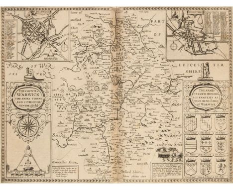
Warwickshire. An album containing maps of Warwickshire, 17th - 19th century, engraved maps by or after Speed, Jansson, Blaeu, Saxton/Kip, Blome, Jefferys, Moll, Seller, Badeslade & Toms, Harrison, Van den Keere and Ordnance Survey, mostly uncoloured and partially or wholly laid onto an album sheet, the Ordnance Survey map is 16 sheets on a scale of 1 inch to 1 mile, 2 copies of the Saxton/Kip (both appear to be the 1610 edition, 2 copies of the Blome and the John Speed is the 1st edition with thread margins, occasional duplicates, various sizes and condition, all bound in a late 19th century half morocco album, boards worn and stained, slight wear to extremities, folio QTY: (1)
![Worcestershire. Speed (John), Worcestershire Described, John Sudbury & George Humble [1616], hand-coloured engraved map,](https://cdn.globalauctionplatform.com/e9dc0ac2-559f-4025-a874-ae7e01100a9c/ce7a25b5-ea63-4071-b5de-ae7f00f6f85b/468x382.jpg)
Worcestershire. Speed (John), Worcestershire Described, John Sudbury & George Humble [1616], hand-coloured engraved map, inset town plan of Worcester, large strapwork cartouche and compass rose, central fold strengthened on verso, 380 x 500 mm, Latin text on verso, together with Doharty (John). A Plan of the City of Worcester with References, 1741, uncoloured engraved city plan, slight creasing and dust soiling, one repaired closed tear affecting the printed image, 475 x 585 mm, with Moll (Herman). Worcestershire, circa 1720, hand-coloured engraved map, the vertical margins decorated with antiquities, 195 x 315 mm, plus Schenk (P. & Valk G). Wigoriensis comitatus cum Warwicensi nec non Coventriae Libertas, Amsterdam, circa 1700, engraved reticulated map with contemporary hand-colouring, uncoloured cartouche, heraldic shields and mileage scale, 430 x 520 mm, and Van den Keere (Pieter). Worcestershire, circa 1627, hand-coloured engraved miniature map, small margins, 85 x 125 mm, English text on versoQTY: (5)
-
109182 item(s)/page