

Ortelius, Abraham. Theatrum Orbis Terrarum Anversa, Abraham Ortelius e Christophe Plantin, 1584. In 2° (390 x 250 mm). Ritratto dell'autore in ovale entro elaborata cornice, 110 carte geografiche a doppia pagina, tutte in coloritura coeva, di cui 12 nel Parergon, Catalogus auctorum con 134 nomi, (mancano la terza parte con il Nomenclator Ptolemaicus, le tavole 4 e 5 con l'Africa e l'America oltre al frontespizio figurato, margini del ritratto e della pagina di dedica reintegrati, esemplare leggermente rifilato con qualche altro difetto e restauro.) Legatura di inizio secolo XIX in pergamena con titolo su tassello arancione, fregi dorati al dorso liscio, tagli verdi (piccoli difetti). Esemplare con bella coloritura di questo atlante considerato il primo atlante moderno. Koeman: "Shape and contents set the standards for later atlases, when the centre of the map-trade moved from Antwerp to Amsterdam. The characteristic feature of the Theatrum is, that it consists of two elements, forming part of a unitary whole: text and maps. This concept for a 'Theatre of the world' was followed through the 17th century. Before Ortelius no one had done this". - TAGS: Libri, libro, books, Viaggi
We found 109182 price guide item(s) matching your search
There are 109182 lots that match your search criteria. Subscribe now to get instant access to the full price guide service.
Click here to subscribe- List
- Grid
-
109182 item(s)/page
![In 2° (296 x 200 mm); [28], 201, [3] pagine. Marca tipografica in fine volume, frontespizio architettonico inciso in rame e 4](https://cdn.globalauctionplatform.com/8c0a4114-6c37-4fdb-ab97-ad41009888f6/b81339e4-7952-4cba-aba4-ad4100a4dfa2/468x382.jpg)
In 2° (296 x 200 mm); [28], 201, [3] pagine. Marca tipografica in fine volume, frontespizio architettonico inciso in rame e 47 carte geografiche incise a mezza pagina, con il mappamondo e la “carta da navigare” che contiene le rotte ed i venti (piccolo abile restauro all’angolo superiore delle prime carte.) Legatura di poco posteriore in bazzana con fregi dorati al dorso e titolo in oro (sguardie nuove). Seconda edizione aumentata. Muller 1255: “Pages 157-184 treat of the American islands, embracing a plan of Temistitan (Mexico), a general map of North-America, maps of Hispaniola, Cuba, Jamaica, S. Lorenzo, S. Giovanni; and, besides, pp. 193-201 a general map and a maritime chart of the world with description”. - TAGS: Libri, libro, books, Viaggi
![Tolomeo, Claudio. La geografia […] nuovamente tradotta di greco in italiano, da Girolamo Ruscelli. Venezia, Vincenzo Valgrisi](https://cdn.globalauctionplatform.com/8c0a4114-6c37-4fdb-ab97-ad41009888f6/a45a1699-29c5-499f-8892-ad4100a4e6b3/468x382.jpg)
Tolomeo, Claudio. La geografia […] nuovamente tradotta di greco in italiano, da Girolamo Ruscelli. Venezia, Vincenzo Valgrisi, 1561. In 4° (235 x 162 mm); 3 parti in 1 volume; [8], 358, [2] pagine; [28] carte; 47, [49] pagine, 64 carte geografiche a doppia pagina delle quali 27 raffiguranti il mondo antico e 37 raffiguranti il mondo moderno con la descrizione al retro, 12 xilografie e diagrammi nel testo, marche tipografiche (delicato restauro al margine inferiore del frontespizio, piccolo foro di tarlo alla piega centrale di alcune carte.) Legatura coeva in pergamena con unghiatura e tracce di due bindelle. Prima edizione nella traduzione di Ruscelli. Importanti le carte della Tierra Nueva con la tierra del Bacalaos e la tierra del Laborador, la carta del Brasile, l’isola di Cuba e di Santo Domingo e la carta della Nueva Hispana che raffigura correttamente la penisola dello Yucatan e riporta i nomi dei luoghi esplorati da Pineda, Cabeza de Vaca e Moscosso. Nodenskiöld 30: “The maps are enlarged copies of Gastaldi’s maps in the edition of 1548, excepting: ‘Universale Novo’ […] and the map of Central America (Nueva Hispania), where Yucatan is drawn as a peninsula, and not separated from the main by a strait as in the map of 1548. Four maps are added, vis.: Toscana, nova tabula; Zeno’s map or ‘Septentrionalium partium tabula nova’; Brasil, nova tavola, and the old map of the world by Ptolemy, excluded from the edition of 1548, is here reinserted”. - TAGS: Libri, libro, books, Viaggi


MIDDLE EASTERN MAP AND PICTURES, ETC, to include 'Oriens Persia, India' map engraved by W.H. Toms, Ahmed Nashaba depicting palm trees and buildings, crayon on paper, Mellor Yelton limited edition print 'Palestinian Woman' 52/500, the world famous Roberts prints limited edition portfolio published in Saudi Arabia, 'Scenes from Jordan' by David Roberts portfolio of prints, published by Jordan Ministry of Tourism, and six prints after Abdullah Ahmen Al-Muharraqi

"Descriptio Orbis Antiqui in XLIV. Tabulis exhibita" a Io. Davide Koelero"; kolorierter Atlas, Christoph Weigel, Nürnberg, um 1720 Dieser Atlas enthält 40 (statt 44) altkolorierte Karten der Alten Welt. Folio (28x38,5 cm), gedruckt bei Christoph Weigel in Nürnberg. Der Atlas zeigt die westliche Welt, mit Karten von Eurasien mit Afrika, Europa, Hispanien, Gallien, der Britischen Inseln, Germanien, Italien, Palästina, Ägypten, Mesopotamien, etc. Viele Karten mit Münzdarstellungen. Koloriertes Titelkupfer, verso Besitzvermerk in Tinte ("Ludwig Grimme, cand. phil., November 1879"), Inhaltsverzeichnis. 40 Karten in schönem Altkolorit (es fehlen die Nummern 9, 15, 23, 24). Am Titel, Index, den ersten beiden Karten sowie den Karten 27 bis 37 Randschaden, ebenso Braunfleck rechts oben von Karten 19 bis 27. Die Schäden jeweils im weißen Rand, ohne Bildverlust. Längsknick in Karte 14 (Italien). Hinterlegter Einriss auf Karte 39 (Mauretania et Numidia) ohne Papierverlust, nicht bis in die Karte reichend. Die Karten selbst nur gering gebräunt und fleckig. Halbledereinband, der Rücken restauriert, teilweise eingerissen, rundum berieben und bestoßen. Der Atlas insgesamt in einem brauchbaren Zustand.Zustand: III"Descriptio Orbis Antiqui in XLIV. Tabulis" by David Koehler; hand-coloured atlas, Nuremberg, circa 1720 Folio, engraved title and index, 40 (of 44) hand-coloured engraved maps of the ancient world. The atlas shows the western world, with maps from Eurasia/Africa, Europe, Hispania, Gallia, the British Isles, Germania, Italia, Palestine, Egypt, Mesopotamia, etc. Many maps decorated with numismatic elements.Coloured title, on the reverse a handwritten property note ("Ludwig Grimme, cand. phil., November 1879"), index. 40 double-page maps (# 9, 15, 23, 24 missing), original coloring. Title, Index, the first two maps and maps 27 to 37 with damages to the white margin, a brown spot in the top corners of maps 19 to 27. The damages limited to the white margins. Map 14 (Italy) bent down the middle. A 4 cm long tear doubled-up with a paper strip on map 39 (Mauretania et Numidia), no loss to paper, not touching the map. Occasional, very light browning and foxing to the maps. The fly-leaves soiled.Contemporary half-vellum over marbled boards with gilt stamped back (repaired, with a 30mm crack front bottom), worn at the corners and around the edges. Overall a still acceptable copy of this skilfully elaborated atlas.Cf. Phillips, Atlases, 30. Condition: III


Herbert Coxon, Oriental Carpets, How they are Made and Conveyed to Europe, with a Narative of a Journey to the East in Search of Them. 10 plates by artist Mr. W.F. Smiles and a fold out map. First Edition 1883. A beautiful book. Perhaps the first book on Carpets and Rugs. Notes: In the early 1980's I made plans with a colleague, who was a film producer and camera man, to follow Coxon's route to Baku, observing the differences between his text and descriptions in 1800's and the current date. We presented the idea to Channel 4 who thought it was a great idea. (nb. This was before Michael Palin). They said they would look at the finished work to let us know how much to pay us. It was impossibly expensive for us to do without any advance.
19th / early 20th century Ordnance Survey style maps to include a cloth version 'Map of the Parish of Stratton in the County of Dorset, Buxton and Matlock OS map sheet 111, Derbyshire sheet SK 16 NE, a Derbyshire County Council map and another similar item (5). Condition as you'd expect. Approx size 90 x 74cm. The cloth example is slightly bigger.


JOHNNIE WALKER SPECIAL COLLECTION (5x5cl) Includes Johnnie Walker Liqueur (40%), Cardhu aged 12 years (40%), Johnnie Walker Gold Label aged 15 years (43%), Johnnie Walker Black Label aged 12 years (43%), and Johnnie Walker Red Label (43%). All 5cl in carton. CLASSIC MALTS OF SCOTLAND (6x5cl) Includes Lagavulin White Horse Distillers aged 16 years (43%), Talisker 10 years old Map Label (45.8%), Cragganmore 12 years old (40%), Dalwhinnie 15 years old (43%), Oban 14 years old (43%), and Glenkinchie 10 years old (43%). All 5cl, in carton. 11 miniatures.


Sale (George)The Koran commonly called the Alcoran of Mohammed, to which is prefixed a Preliminary Discourse. London: C. Ackers for J. Wilcox, 1734, front page missing, cover loose, contains folding engraved map of Arabia, folding plan of Mecca, three engraved genealogical tables (two folding), some light staining to pages, calf bound but cover needs attention.
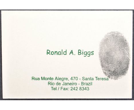
The Great Train Robbery - Ronnie Biggs (1929-2013) - an original personal business card from Biggs, as given out whilst he lived in Rio De Janeiro. The card features text ' Ronald A. Biggs ' alongside Biggs' fingerprint in ink (a homage to his criminal past). The bottom of the card features his address and to the reverse, a map. Unique item of Great Train Robbery related memorabilia. 6x9cm.

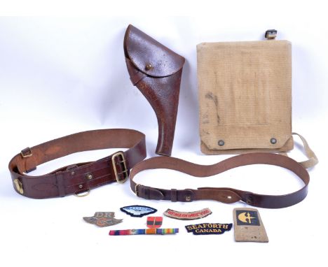
A collection of assorted WWII Second World War British and Canadian Army uniform items and cloth patches. The collection to include and original Sam Browne belt, a pistol holster, a RAF Royal Air Force map case, Dispatch Riders cloth patch, medal ribbon bar and a selection of Canadian Army cloth patches.

Two original WWI First World War period maps, comprising:- Trench Map: Bailleul-Kemmel area. Sheet 28 SW, edition 6. Belgium & France. Coded in bottom l/h corner GS GS (General Staff Geographical Section) 2742 and published by the Ordnance Survey December 1916. On folding linen. Scale 1:20,000. Size 89 by 65 cm. Detailed key. Original owner’s name to reverse. The owner served in the Durham Light Infantry and the Northumberland Fusiliers, and was wounded in France- British Army map of Amiens, published by the Ordnance Survey, Southampton for the Geographical Section General Staff 1916. Code 2364 to bottom left corner. On folding linen size 88 by 66 cm. Scale 1:100,000. Key gives information on many geographical features and has an explanation of French names for them. Soldier’s name in pencil above front cover.
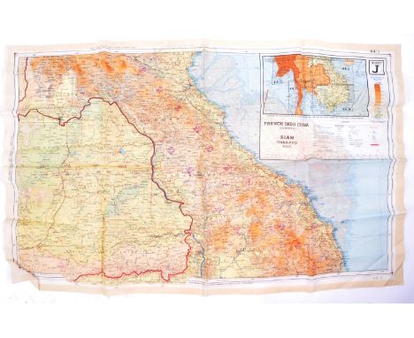
An original WWII Second World War British RAF Royal Air Force silk escape map. South-east Asia sheets 44 J and K. Two back-to-back escape maps on one folding silk map. Size 95 by 60 cm. Scale 1:000,000. Folds to pocket handkerchief size or smaller. Side J covers French Indo-China (central), Siam (Thailand east) and side K covers an area of French Indo-China (south), Siam (Thailand- part). Maps are in colour with a colour-coded key to heights and a conventional key to features such as mountains, islands, railways, stations, ruins, post offices, roads etc.
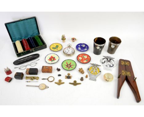
Mixed collection of items to include two silver mounted horn cups, 9.5cm high; silver plated Goliath pocket watch, 7.5cm diameter; tortoiseshell stamp box, 2.5cm high, 5.5cm wide, 3.5cm deep; poker chips in leather case, 5cm high, 19cm wide, 13cm deep; opisometer map measurer, 11cm high; a Thuringia porcelain miniature of a vase of flowers, 5.5cm high; a Royal Worcester porcelain miniature vase painted with a bird, 3cm high, 5cm diameter; a miniature porcelain tea cup in the Imari palette, 2cm high; 19th century glasses in mother of pearl inlaid papier mache case, 15.5cm long (case); 19th century manometer in case, 8cm high (case); five enamel dishes, 8.5cm diameter; two AA badges, largest 11cm high; three Airforce badges, amethyst figurine of a rabbit, 2.8cm high; small pendant in the form of a pig, 2cm wide, miniature mirror with cloisonné enamel to reverse, 6.5cm high, two thimbles in a miniature basket weave container, 3cm high, leather lighter, 5.5cm high, and a vintage wooden shoe stretcher, 25cm long (27)


Colletion of maps to include North Riding of Yorkshire by John Cary, 1787, 22 x 27cm; Rutlandshire by John Cary, 1793, 23 x 27cm; Kent by John Cary, 1793, 23 x 27cm; Durham by J Wilkes, 1803, 19 x 23cm; Durham published by G & J Cary, 16 x 10.5cm; and a map of a section of south-east London, 17 x 11cm (6)


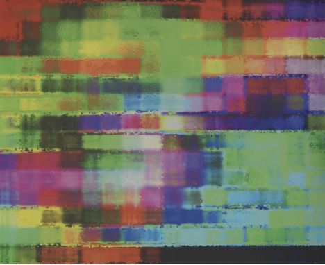
Wolfgang M. Heckl - - 1958 Parsberg - lebt und arbeitet in München und Partenkirchen Phantom of the Opera. 2021. Aludibond, bedruckt und gebürstet. Verso signiert, datiert und bezeichnet. 100 x 120 cm (39,3 x 47,2 in). • Unikat. • Erstmals auf dem internationalen Kunstmarkt angeboten. • KI-Kunst auf der Grundlage des Musicals 'Phantom of the Opera'. Schon 1911 hat Wassily Kandinsky in seiner 'Improvisation III' mit seiner natürlichen Intelligenz als Künstler interpretiert, was er sah und fühlte während eines Konzerts. Im 21. Jahrhundert können Computer diesen Prozess übernehmen, sie können sowohl Musik in Kunst überführen als auch die Umkehrtransformation möglich machen, so wie z. B. Heckl schon 2006 atomare Landschaften aus seiner rastertunnelmikroskopischen Forschung mithilfe eines analytischen Algorithmus in atomare Klanglandschaften übersetzt hat. (Vgl.: Wolfgang M. Heckl. Atomare Klangwelten. Technical Report 1/2006, Andrea von Braun Stiftung, 2006, und Wolfgang M. Heckl. Moselculism. In Peter Weibel und Ljiljana Fruk, editors, Molecular Aesthetics, pages 361-367. ZKM/Center for Art and Media, Karlsruhe, 2013.) Bei 'Phantom of the Opera“ wurde ein ganz neuer Weg beschritten: Ein neuronales Netz wurde trainiert, mithilfe eines Variational Auto Encoders (VAE) anhand von mehreren zehntausend Bildern zu lernen, wie die visuelle Information in einen 512-dimensionalen Vektor kodiert werden kann, der dann als Funktionstest nach Dekodierung das ursprüngliche Bild wieder rekonstruiert. Ein simultanes Verfahren wurde im 2. Schritt auf zehntausende Musikstücke (midi-files) angewendet, so wie im 1. Schritt einen Picture-Variational Outoencoder (PictureVAE) nun einen MusicVariationalAutoEncoder (MusicVAE) zu generieren. Dabei wurden mit einer frei wählbaren Note Color Map den Noten Farben usw. zugeordnet. Im 3. Schritt wurde in der Programmiersprache Python das entscheidende Translations neuronale Verbindungsnetzwerk geschaffen (TNN), um den MusicVAE mit dem PictureVAE zu verbinden. Als Ergebnis kann damit die neuronale KI biderektional Musik und Bilder verbinden. (Vgl.: K. Wienand und W. M. Heckl, Neural Networks to Bidirectionally Connect Pictures and Music, eingereicht bei Leonardo, 2021) Als Funktionstest dient dabei die selbständige wiederholte Interpretation eines Musikstücks in ein Kunstwerk durch die eigenständige KI, die zu ähnlichen Resultaten führt. Viel Raum bleibt dabei zu spekulieren, ob die KI tatsächlich einen eigenständigen, vom analog arbeitenden menschlichen Künstler unabhängigen Mehrwert generieren kann, so wie man es von heutiger KI im Bereich der Mustererkennung, des menschlichen Sprachverständnisses oder der Vorschlagsalgorithmen auf einschlägigen Verkaufsportalen kennt. Aufrufzeit: 19.06.2021 - ca. 17.41 h +/- 20 Min. Dieses Objekt wird regel- oder differenzbesteuert angeboten.ENGLISH VERSIONWolfgang M. Heckl -1958 Parsberg - lebt und arbeitet in München und Partenkirchen Phantom of the Opera. 2021. Alu-dibond, printed and brushed. Signed, dated and inscribed on the reverse. 100 x 120 cm (39.3 x 47.2 in). • Unique object. • Offered on the international art market for the first time. • AI artwork on the basis of the musical 'Phantom of the Opera'. Called up: June 19, 2021 - ca. 17.41 h +/- 20 min. This lot can be purchased subject to differential or regular taxation.


![[MAP OF POLAND AND THE BALTIC STATES] ALBRECHT CARL SEUTTERDucatus Pomeraniae Citerioris et Ulterioris. Principatibus, Comita](https://cdn.globalauctionplatform.com/84faf6f9-7f61-4cb4-af98-ad360096a820/00f596c4-fe4c-4036-88bb-ad3600fdef2e/468x382.jpg)
[MAP OF POLAND AND THE BALTIC STATES] ALBRECHT CARL SEUTTERDucatus Pomeraniae Citerioris et Ulterioris. Principatibus, Comitatibus urbibus suis definitae Nova et Ampla Descriptio geographica. Augsburg, c. 1760. Six sheets joined to one large map, 98 x 167.5 cm. Map and title cartouche coloured. Paper slightly browning. First edition of Seutter’s 6-sheet map of Pomerania, first published in about 1760. The map was later re-issued by Conrad Tobias Lotter, with the title re-engraved. Seutter’s map is a simplified version of Lubben’s map, issued in approximately the same scale, but with numerous revisions and improvements. Showing the region on the south coast of the Baltic shared between Germany and Poland, from the Recknitz River near Stralsund in the west, via the Oder River delta near Szczecin, to the mouth of the Vistula River near Gdansk in the east. Created by Professor Lubben of Rostock University on the orders of Philipp II, Duke of Pomerania, who wanted a large-scale map that would be a comprehensive geography and history of the duchy. Although Lubben had mapped the island of Rugen on the Pomeranian coast in 1609, he had very little geographic information to guide him: the only map to precede this one of Pomerania was a small map by Peter Artopaus (later used by Münster and Ortelius). Lubben spent two years travelling throughout the country taking thousands of measurements, it was then another 6 years before the copperplates were completed, by Geelkerken in Amsterdam. However, although a very small number of the sheets printed in 1618 are known to have been presented to the Pomeranian court, the shortage of paper, and the 30 Years’ War intervened, and no known copies of this printing have survived. It was not until 1757, after Geelkerken’s original copperplates were discovered in the in Stralsund (a town featured in a vignette on the map), that the map was reissued. Lubben’s map was the model for virtually all atlas maps of Pomerania of the seventeenth century, including those of Blaeu and Janssonius, and Hondius dedicated his famous wall map of Asia to Lubben: see Shilder, «Monumenta Cartographica Neerlandica» VI, pp.150-151. It remained the only map of consequence of the region from its inception in 1618 until the Prussian topographical survey of the eighteenth century.


FREDERICK SHAW MITCHELL: THE BIRDS OF LANCASHIRE, London, John van Voorst, 1885, 1st edition, folding frontis map, 11 plates including 2 hand coloured, original cloth gilt, inner joints weak + JOHN WALPOLE-BOND: FIELD-STUDIES OF SOME RARER BRITISH BIRDS, London, Witherby & Co, 1914, 1st edition, title page rubber stamped "Archive copy", original cloth + SIR THOMAS DIGBY PIGOTT: LONDON BIRDS AND OTHER SKETCHES, London, Edward Arnold, 1902, new edition, revised and enlarged, original cloth gilt + CLAUD BUCHANAN TICEHURST: A HISTORY OF THE BIRDS OF SUFFOLK, London and Edinburgh, Gurney & Jackson, 1932, 1st edition, original cloth, (4)

MALCOLM SAVILLE: 3 titles: WINGS OVER WITCHEND, London, George Newnes, 1956, 1st edition, signed on half title, original cloth, spine a little toned; LONE PINE LONDON, London, George Newnes, 1957, 1st edition, inscription verso of map end paper, original cloth, d/w (minor losses and repairs); THE SECRET OF THE GORGE, London, George Newnes, 1958, 1st edition, some clear adhesive tape residue on front map end paper, original cloth, d/w (very minor faults) (3)


MALCOLM SAVILLE: 2 titles: TREASURE AT AMORYS, London, George Newnes, 1964, 1st edition, rubber stamps of Jarvis Library Dept on introductory leaf and rear blank, clear adhesive tape residue verso of front map end paper and half title, original cloth bright gilt, d/w (spine faded and some clear adhesive tape residue); MAN WITH THREE FINGERS, London, George Newnes, 1966, 1st edition, inscription verso of map end paper, numeral on half title, original cloth, d/w (2)

-
109182 item(s)/page