We found 109182 price guide item(s) matching your search
There are 109182 lots that match your search criteria. Subscribe now to get instant access to the full price guide service.
Click here to subscribe- List
- Grid
-
109182 item(s)/page


Lot 240
India & Persia - Capt. Sir Alexander Burnes F.R.S. - Travels into Bokhara, The narrative of a Voyage on the Indus from the Sea to Lahore & an account of a Journey from India to Cabool, Tartary and Persia, New Edition with a Map and Illustrations, 1839, John Murray, London, 3 vols, frontis of Ranjit Singh, contemp. full calf with gilt lined edge and spine, a.e.m, 16mo; together with An Historical and Descriptive Account of Persia from the Earliest Ages to the Present Time....Including a Description of Afghanistan and Beloochistan, James B. Fraser, 2nd edn., Oliver & Boyd, Edinburgh, 1834, contemp. full calf with gilt lined edge and spine, 16mo. (4)


Lot 127
Janssonius-Hondius, Appendix Atlantis (Amsterdam 1637) 380x500mm, copy from Willem Janszoon and Joan BLAEU , " Cyprus Insula ", Theatrum Orbis Terrarum , sive Novus Atlas , Amsterdam 1635. Copper engraved map of Cyprus with Aphrodite in the right corner , circa 1637. Verso Latin text. Coloured.


Lot 130
PORCACCHI TOMMASO. Woodcut map of Cyprus from the book “L Isole piu famose del mondo”. A detailed map of Cyprus, and one of the earliest to show the island by itself, publication date: circa 1590. This map appears in 'L'isole piu famose' by Tommaso Porcacchi, first published in 1572. The isolario, or island book, was a genre developed in the Mediterranean over the sixteenth century as a unique blend of literature, geography and art. 'L'isole' was the first isolario with maps engraved on copper. Size of page: 270X170mm, size of map: 105X140mm. Both sides with Italian texts.


Lot 1
Allom (Thomas, illustrator). Constantinople and the Scenery of the Seven Churches of Asia Minor, illustrated. In a Series of Drawings from Nature. With Descriptions of the Plates by Robert Walsh, 2 volumes in 1, Peter Jackson, late Fisher, Son, & Co, [circa 1845], together with Allom (Thomas, illustrator, & others), Belgium, the Rhine, Italy, Greece, and the Shores and Islands of the Mediterranean, illustrated in a Series of Beautifully-Executed Engravings, with Historical, Classical, and Picturesque Descriptions, by G. N. Wright, and L. F. A. Buckingham, 2 volumes, Peter Jackson, late Fisher, Son, & Co., [1851], Constantinople with 2 engraved frontispieces, 92 engraved plates including frontispieces, vignette titles, map, tissue-guards, Belgium with 2 frontispieces, 150 plates, vignette titles, tissue-guards, occasional spotting and marginal damp-staining in both works, stronger in frontispieces, vignette titles and final plates, a few marginal nicks, contemporary ownership inscriptions, ink-stamps and ink-flecks to endpapers and vignette titles, all edges gilt, uniform contemporary hard-grain red morocco gilt, rubbed and worn, Constantinople headcap chipped, Belgium volume 2 front joint tender, 4to Cf. Atabey 1316 and Blackmer 1766 for the first work. (3)
Lot 10
Bry (Johann Theodor & Johann Israel de). Warhafftige Vorbildung der V”lcker, sampt iren K”nigen mit iren Ceremonien, G”tzendienst, Sitten und Polecey-Ordnung, beyder Reysen oder Schiffarten so in diesem Buchbeschrieben sindt..., Frankfurt: Matthias Beckern, 1605, 22 engraved illustrations including two double-page (bird's-eye view of city of Kandy, Ceylon, and map of Ceylon), some soiling, damp-staining and damp fraying, several closed tears with old paper repairs to versos, repairs to upper outer corner of f2 and lower outer corner of g4, the latter with significant text loss affecting all but first three lines, red wax seal with crown affixed to title, later wrappers, slim folio Collation: a-b4, c-d2, e-g4, [1]. The final part of volume 7 of the first German edition of De Bry's Great Voyages: Der Orientalischen Indien, published in 13 volumes. (1)
Lot 13
Candlin (G.T.). John Innocent, a story of mission work in North China, United Methodist Publishing House, 1909, portrait frontispiece and 24 illustrations from photographs, contemporary presentation inscription to rear endpaper 'Jessie Champion with love from Aunt Innocent. Brighton, Dec 7th 1909', original gilt-decorated brown cloth, lightly rubbed, 8vo, together with [Jesuit Missionaries]. Lettres Edifiantes et Curieuses, ecrites des Missions etrangeres, Memoires des Indes, volume 15 only (from the complete set of 26 volumes), Paris, J.G. Merigot, 1781, 4 folding engraved maps, missionary college oval library stamp to half title and title only, contemporary calf, joints cracked and wear to edges, 12mo, plus Lindley (Captain Augustus F.), The Log of the Fortuna: A Cruise on Chinese Waters, 2nd edition, Cassell, Petter & Galpin, circa 1875, wood engraved illustrations, some light spotting and minor marks, school prize label to front pastedown dated July 1889, remains of sellotape to inside front cover, original gilt-decorated purple cloth with oval gilt stamp of Cherville College, Romsey, to centre of rear cover, rubbed and minor fraying to extremities, spine faded and partly detached along rear joint, large 8vo, and 5 others various: A.B. Lloyd, In Dwarf Land and Cannibal Country, a record of travel and discovery in Central Africa, 1st edition, 1899, University library stamps, original cloth, rubbed and some marks, Commodore Anson, The Voyage of Commodore Anson Round the World, printed by T. Maiden for Ann Lemoine and J. Roe, circa 1820s, 12mo, Cecil Beaton, Chinese Album, 1st edition, Batsford, 1945, Richard J. Lane, Life at the Water Cure or A Month at Malvern, 1846, & John Wallis, Wallis's Tour Through England and Wales, a new geographical pasttime, 1794, hand-coloured engraved map, sectionalised on linen, with printed instructions and historical descriptions to left and right side, worn with a little loss (with all faults) (8)
Lot 130
Allegorical map. Seutter (Matthaus), Representation Symbolique et ingenieuse projett‚e en Siege et en Bombardement, comme il faut empecher prudemment les attaques de L'amour..., published Augsburg, circa 1730, engraved map with contemporary hand colouring, a list below the map describes methods for defending the heart from the attack of love, title repeated in German, 500 x 570 mm, together with two small 'maps of matrimony' including one in postcard form, with Emslie (John), Telescopic appearance of the Moon, circa 1850, a 'hold to light' uncoloured engraving of the moon, printed on fine paper to enable light to pass through the paper and 'illuminate' the image, overall size 280 x 225 mm, plus Hole (G. / Saxton Christopher), Eboracensis comitatus...., East Riding, [1610], hand coloured engraved map, some staining to margins, 200 245 mm The first described item is a scarce allegorical representation of love. It shows the fortress of manhood being bombarded by the fairer sex. (5)
Lot 131
Australasia. A collection of twelve maps, 18th & 19th century, including nine regional engraved maps of New Guinea and Australia by Vandermaelen, all with contemporary outline colouring, two (duplicate) charts by Bonne of the coast of Tasmania and a map of Polynesia and Australasia by Neele (12)
![Austria. Ortelius (Abraham), Austriae ducatus chorographia Wolf Gango Lazio auctore, [1579], hand coloured engraved map, slig](https://cdn.globalauctionplatform.com/99e29864-97e2-4325-a07f-a8f900e267c0/094281eb-63ac-4996-d31c-115305495847/468x382.jpg)
Lot 132
Austria. Ortelius (Abraham), Austriae ducatus chorographia Wolf Gango Lazio auctore, [1579], hand coloured engraved map, slight staining to margins, 345 x 470 mm, Latin text on verso, together with Carinthiae ducatus et Goritiae palatinatus Wolf. Lazio [on sheet with] Hastriae tabula a Petro Coppo descri. [and] Zarae et Sebenici descriptio, [1612], three hand coloured engraved maps on one sheet (as published), 330 x 485 mm, Spanish text on verso Marcel van den Broecke. Ortelius Atlas Maps, nos. 105 & 143 respectively. (2)
Lot 134
Board games. John Waddington Ltd. (manufacturers), G. H. Q. War game, circa 1940, colour printed board game based on a map of Europe, 535 x 720 mm, including the manufacturer's printed card box containing dice cup and dice and 'flag' pieces of British, French and Nazi Germany, book of rules, and a printed pamphlet on suggested 'successful attack strategy', with another board and pieces but with the board worn and a little frayed along central fold, plus a small American manual dexterity game called 'Trap the Jap', a printed map box of Japan, Guam, The Marshall Islands, Singapore etc. with various coloured marbles which have to be rolled into these principal targets, box size 115 x 115 mm (5)
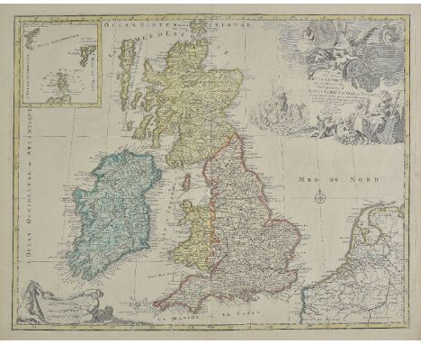
Lot 137
British Isles. Janvier (Jean), Les Isles Britanniques comprenant les Royaumes D'Angleterre, D'Ecosse et D'Irlande divisŠs en grandes provinces..., published Paris, circa 1780, engraved map with contemporary outline colouring, inset map of the Orkney & Shetland islands, slight overall toning, 315 x 450 mm, together with Thomson (John & Co., publishers), British Isles, circa 1815, engraved map with contemporary outline colouring, inset map of the Orkney & Shetland islands, 610 x 510 mm, with Cary (John), A New Map of the British Isles from the latest authorities, 1807, engraved map with contemporary outline colouring, inset map of the Shetland islands, 475 x 530 mm, plus De Vaugondy (Robert), Carte des Grandes Routes D'Angleterre, D'Ecosse et D'Irlande, 1757, engraved map with contemporary outline colouring, 475 x 580 mm, and Andriveau (J.), Carte G‚n‚rale des Isles Britanniques contenant L'Angleterre, L'Ecosse et L'Irlande..., published Paris, 1837, engraved map with contemporary outline colouring, inset map of the Shetland Islands, 860 x 620 mm, with Agas (Ralph), Civitas Londinum, circa 1874, large uncoloured folding lithographic panorama, toned overall, slight loss along old folds, 700 x 1860 mm, bound in contemporary cloth gilt boards, spine partially lacking (6)
Lot 138
British Isles. British Isles. De L'Isle (Guillaume), Les Isles Britanniques ou sont le Rme. d'Angleterre tir‚ de Sped celuy d'Ecosse tir‚ de Th. Pont &c. et celuy d'Irlande tire de Petti. Le tout rectif‚ par diverses observations..., published Paris, 1702, engraved map with contemporary outline colouring, large uncoloured decorative cartouche, central fold strengthened on verso, slight spotting to margins, 470 x 620 mm, together with Lotter (Tobias Conrad), La Grande Bretagne ou les Royaumes D'Angleterre et D'Ecosse comme aussi le Royaume D'Irlande divis‚e par provinces..., circa 1770, engraved map with contemporary hand colouring, slight creasing, old folds, near contemporary manuscipt text to verso, 495 x 585mm The first described item. R. W. Shirley. Printed Maps of the British Isles 1650 - 1750. Delisle 1. state 1. (Does not show Harwich). (2)
Lot 139
British Isles. Elwe (Jan, & Jaillot Alexis Hubert), Les Isles Britanniques qui contiennent les Royaumes d'Angleterre, Escosse et Irlande..., published Amsterdam, 1792, engraved map with contemporary outline colouring, inset map of the Orkney and the Shetland islands, large uncoloured cartouche and mileage scale, 480 x 600 mm, together with Covens (J. & Mortier C.), Regnorum Magnae Britanniae sive Angliae, Scotiae nec non Hiberniae nuperrima delineatio..., circa 1720, engraved map with contemporary hand colouring, inset map of the Orkney Islands, large decorative cartouche, old folds, 510 x 595 mm The first map described:- R. W. Shirley. Printed Maps of the British Isles, 1650 - 1750. Jaillot 4 state 5. (2)
![British Isles. Magini (Giovanni), Britanicae Insulae, [1608], hand coloured engraved map, 130 x 170 mm, Latin text on vero, t](https://cdn.globalauctionplatform.com/99e29864-97e2-4325-a07f-a8f900e267c0/0545dfa8-9acf-4184-debc-4cfd8a72f34c/468x382.jpg)
Lot 141
British Isles. Magini (Giovanni), Britanicae Insulae, [1608], hand coloured engraved map, 130 x 170 mm, Latin text on vero, together with Ortelius (Abraham), Ingiltera, [1598], uncoloured miniature engraved map, orientated to the west, 75 x 105 mm, Italian text below and on verso of map, with Bertius (Petrus), Magna Britannia, circa 1637, hand coloured engraved map, orientated to the west, 100 x 140 mm, plus Van den Keere (Pieter), The Kingdome of England, [1627], hand coloured engraved map, slight staining and old watercolour to margins, 85 x 125 mm, English text on verso, and Mercator (G. & Hondius H.), Anglia, [1631], uncoloured engraved map, slight overall toning, 145 x 200 mm, German text on verso, with De Val (Pierre), Angleterre, circa 1672, uncoloured engraved map, 100 x 125 mm (6)

Lot 142
Cartographic curiosity. Ottens (Joachim), Carte qui represente toutes les pieces qui sont comprise dans l'architecture militaire ou l'art des fortifications..., published Amsterdam, ciorca 1730, engraved map with contemporary hand colouring, decorative martial cartouche, compass roses, slight creasing, 490 x 615 mm, mounted An unusual illustrative map showing military objects, weapons, cannons, mortars, fortifications, buildings, ships, bridges and tools, with an extensive key with more than eighty-four descriptions below the map. (1)
Lot 143
Cycling maps. Pattisons (Scotch Whisky Limited, publisher), A collection of twenty cycling maps, circa 1898, folding lithographic pictorial images of various sports and pastimes including sailing, shooting, curling, golf, hunting and cycling on the verso with a colour lithographic regional map on the recto, each bound in publisher's decorative coloured cloth, occasional duplicates, map size 325 x 225 mm, when bound the binding size is 85 x 60 mm, together with Dyson (Thomas, publisher), Cyclist's Road map of Yorkshire, circa 1898, folding colour lithographic map, 275 x 345 mm, publisher's red cloth binding, when bound 95 x 65 mm, with Bradley (Tom), Jackson's Cyclist's Guide to Yorkshire, published Richard Jackson, Leeds, 1900, title page with later biro ownership signature and a near contemporary ink ownership stamp, large folding map bound at rear, endpapers and pastedowns comprising of various cycling related advertisements, front pastedown with an additional ownership signature, hinges weak, contemporary decorative red cloth, a little stained and worn at extremities, spine faded, 8vo The Pattison maps comprise of:- Cumberland Westmorland etc., Norfolk & Suffolk (2), Dorset Wilts Hampshire etc., Lancashire and Isle of Man, Hereford Worcester Gloucester Oxford etc. (2), North Wales (2), South Wales, Cornwall (2), Devonshire (2), Northumberland and Durham (2), Shropshire Cheshire Staffordshire & Derbyshire, East Central Counties, Essex & Kent [and] Yorkshire. (22)
Lot 144
Daily Telegraph (publishers). The Picture Map of London, Antartica, Cruising and Shipping Chart, Great Britain, Map of Africa, Europe, Far East, Middle East India & Pakistan [and] The World, circa 1960, together nine colour printed pictorial folding maps, various sizes and condition, together with Perrier (publishers), Motor Map of England & Wales, circa 1950, fifteen photo-lithographic card maps, with index tabs, contained in publisher's green leather carrying case with a perspex 'window' overall size 340 x 275 mm, with twenty eight mid 20th century colour lithographic linen backed school maps showing geological profiles, rainfall, agriculture, fishing and political data for Europe, British Isles, North America and Australasia, each approximately 1050 x 850 mm, various condition (38)

Lot 145
Denmark & Scandanavia. A collection of ten maps, mostly 18th & 19th century, including Laurie (Robert & Whittle James, publishers), A New Map of the Northern States containing the Kingdoms of Sweden, Denmark and Norway with the western parts of Russia, Livonia, Courland &c., 1794, engraved map with contemporary outline colouring, slight toning to central fold, 475 x 650 mm, together with Moll (Herman), A New Map of the Baltic &c., circa 1720, engraved map with contemporary outline colouring, inset map of the passage into the Baltic Seas, slight staining, old folds and occasional marginal closed tears, strengthened on verso, 520 x 625 mm, with Jansson (Jan), Nova et accurata descriptio totius Fioniae vulgo Funen [and] Lalandriae et Falstripae accurata descriptio, circa 1660, two uncoloured engraved maps, each approximately 410 x 510 mm, no text on verso, with six others similar, including examples by Arrowsmith, Mercator and Thomson, various sizes and condition (10)

Lot 146
*Drayton (Michael). Pembroke and Carmarthenshire, circa 1612, hand coloured allegorical map, 250 x 335 mm, mounted, framed and glazed, together with Kitchin (Thomas), A Map of Pembroke drawn from an actual survey, circa 1760, hand coloured engraved map, 165 x 215 mm, mounted, framed and glazed (2)


Lot 148
*Drayton (Michael). Middlesex & Hertfordshire, circa 1612, untitled hand coloured engraved allegorical map, 250 x 330 mm, mounted, framed and glazed, together with Morden (Robert), Middlesex, [1695 or later], hand coloured engraved map, trimmed to margins, slight creasing, 365 x 415 mm, mounted, framed and glazed (2)

![England & Wales. Aleph (Harvey William), England, published Vincent Brooks, Day & Son, Ltd. [1869], chromolithographic anamor](https://cdn.globalauctionplatform.com/99e29864-97e2-4325-a07f-a8f900e267c0/2c0f4772-c1df-4f4f-b37a-657c88cbf845/468x382.jpg)
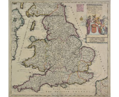
Lot 153
England & Wales Cary (John), Cary's Pocket Companion to the Roads of Great Britian shewing all the post & market towns with the days prefixed on which they are held and the exact distances from the metropolis, 1791, engraved map with contemporary outline colouring, sectionalised and laid on linen, inset map of Scotland, additional title in French above map, 560 x 460 mm, contained in a contemporary marbled card slipcase, slight wear to extremities, with, Rocque (John), The Traveller's Companion or the post roads of England and Wales with the distances in measured miles..., published Laurie & Whittle, 1794, engraved map with contemporary outline colouring, sectionalised and laid on linen, 535 x 525 mm, contained in a contemporary marbled card slipcase with publisher's printed label to upper board, worn and frayed, plus Sayer (Robert), A new Map of the Roads of England and Scotland with the distances in measured miles from place to place..., 1789, engraved map with contemporary outline colouring, sectionalised and laid on linen, inset map of 'Continuation of the roads of Scotland' 745 x 590 mm, contained in a contemporary marbled card slipcase with publisher's printed label to upper board, and Faden (William, publisher), A New Map of England, Wales & Scotland describing all the direct and principal cross roads in Great Britain with the distances measured between the market towns and from London to accompany Paterson's Book of the Roads, 1801, engraved map with contemporary outline colouring, sectionalised and laid on linen, inset map of Scotland, slight overall toning, 730 x 610 mm, contained in a contemporary card slipcase, heavily worn and frayed, with Merian (Matthaus), Magnae Britanniae et Hibernia Tabulae, circa 1650, hand coloured engraved map, inset map of the Orkney Islands, some marginal repaired closed tears, the whole backed with archival paper, 270 x 355 mm, together with De Lisle (Guillaume), Cartes des Isles Britanniques..., circa 1720, hand coloured engraved map, old folds, trimmed to neatline along right hand vertical margin, 400 x 355 mm (6)

Lot 157
England & Wales. Danckerts (Cornelius), Accuratissima Angliae regni et Walliae principatus descriptio..., published Amsterdam, circa 1696, engraved map with contemporary outline colouring, central fold strengthened and repaired on verso, trimmed to neatline at base, some margins dust soiled and stained, 515 x 535 mm, together with Valk (Gerard & Leonard), Magna Britannia aut Anglia, Scotia et Hibernia..., circa 1705, engraved map with contemporary hand colouring, inset map of the Orkney and Shetland Islands, some staining, 490 x 590 mm R. W. Shirley. Printed Maps of the British Isles 1650 - 1750. Danckerts 3, one state only [and] Valk 2, one state only. (2)
Lot 159
Europe. Ortelius (Abraham), Lumen historiarum per occidentem ex conatibus Fran. Haraei, [1624], hand coloured engraved map with descriptive text on three borders, map size 270 x 345 mm, Latin text on verso, together with Santini (Francois), L'Europe divis‚e en ses principaux etats..., published Venice, [1784], engraved map with sparse contemporary outline colouring, 470 x 645 mm, with Gibson (J.), Le Carte de L'Europe, 1754, engraved map with contemporary hand colouring, 485 x 570 mm, plus eight engraved sheets of celestial, astrological and astronomical projections by Desnos, a hemispheral projection of the world by Levasseur and three others similar, various sizes and condition (15)
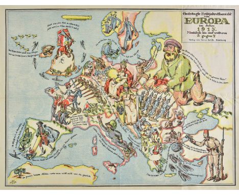
Lot 160
Europe. Gedr„ngte Frhjahrsbersicht von Europa im Jahre 1915, Masstab bis auf weiteres 3 gegen 7, published Verlag von Lucas Gr„fe, Hamburg, 1915, colour lithographic map of Europe, old folds, 515 x 670 mm, together with a copy of 'Der Brummer - Lustige Kriegs Blatter, no.4, 1914', a disbound German magazine with a caricature on the front cover showing a German Feldgrau and a a savage British Spider fighting over the globe, slight fraying to gutter edge, 385 x 250 mm The first described item is one of a pair of satirical maps showing Europe before Italy's entry into the conflict on the side of the allies. The initials of the artist (A.K.) to the lower left of the map have been attributed to the reknowned German historical painter Arthur Kampf. (2)
Lot 163
France & Italy. De L'Isle (Guillaume), Carte de Provence et des terres adjacentes, 1715, engraved map with contemporary outline colouring, some marginal closed tears, slight soiling and smudging, 480 x 605 mm, together with Senex (John), Italy distinguished according to the extent of all the states, kingdoms, republicks, dukedoms, principalities &c. that do at present divide it..., 1719, engraved map with contemporary outline colouring, inset map of Sicily, slight overall toning, some repaired marginal closed tears, central fold repaired and strengthened on verso, 495 x 565 mm (2)
Lot 166
France. A collection of six large scale maps of Saumur, Bressuire-Niort, Loches, Confolon, St. Jean D'Angely and Aigurande, published by the Depot de la Guerre, circa 1860, six uncoloured engraved maps, sectionalised and laid on linen, each approximately 570 x 840 mm, each with a contemporary marbled paper chemise and contained in six individual marbled card slipcases with calf gilt title labels to spines, slight wear Each map has a printed label 'Librairie Militaire de J. Dumaine. Cartes du Depot de la Guerre et du Depot des fortifications. The date on the maps would indicate that they were published for the military campaigns of the French second empire. The imperial Bonapartist regime of Napoleon III from 1852 to 1870, which was sandwiched between between the Second Republic and the Third Republic. (6)NB: This should read - Seven maps contained in six slipcases

Lot 168
Geological map. Walker (J. & C., publishers), A Geological Map of England & Wales showing also the Inland navigation by means of rivers and canals..., 1835, large engraved map with contemporary hand colouring, sectionalised and laid on linen, calligraphic title, explanation key and geological profile at base of map, slight overall toning, 1250 x 985 mm, contained in a contemporary calf gilt bookbox, worn and frayed Some of the railways highlighted on the map were constructed after 1835 which would indicate that the colouring for the railways is slightly later than the published date. (1)

Lot 169
Geological map. Geikie (Archibald), Geological Map of the British Isles, published W. & A. K. Johnston, Edinburgh, 1879, colour printed lithographic map, sectionalised and laid on linen, inset map of the Orkney & Shetland Islands, table of explanation, illustrated with numerous inset illustrations of fossils, 1265 x 1075 mm, red cloth endpapers, contained in publisher's red cloth gilt slipcase, a little frayed and split along one seam, supplied with the 106 page explanatory booklet, 'Outlines of the Geology of the British Isles to accompany the Geological Map, 1876', advertisements to pastedowns, publisher's cloth gilt, 8vo, An uncommon map as most of Geikie's maps are of England & Wales only and unusual to find it with the explanatory booklet. (1)
Lot 170
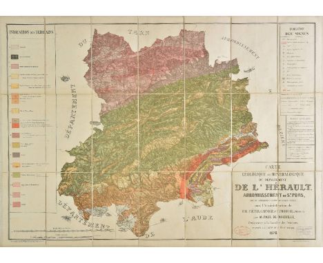
Geological Maps. De Rouville (Paul), Carte g‚ologique et min‚ralogique du d‚partement de l'H‚rault arrondissement de Montpellier..., published Lemercier, Paris, 1876, colour lithographic map on four sheets, sectionalised and laid on linen, each with two ink library stamps, table of explanations on each sheet, each approximately 980 x 710 mm, contained in a contemporary marbled card slipcase, some wear to extremities (4)
-
109182 item(s)/page