We found 109182 price guide item(s) matching your search
There are 109182 lots that match your search criteria. Subscribe now to get instant access to the full price guide service.
Click here to subscribe- List
- Grid
-
109182 item(s)/page


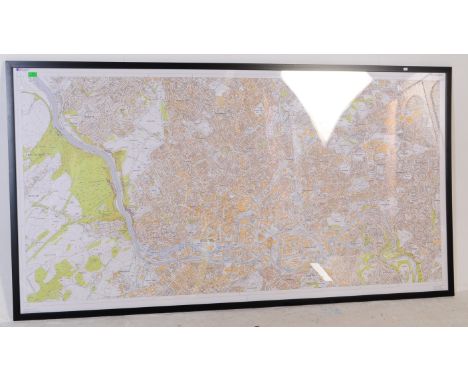

Lot 490
A collection of pictures to include AFTER W BEECHEY "Children relieving a beggar boy...", engraved by C Wilkin and published by W Beechey May 1796, 50 cm x 37 cm, AFTER J H DOWD "Young boy with sheepdog", engraving, signed in pencil lower right, 28.5 cm x 20 cm, AFTER P.B HICKLING "Help", colour print, published by Richard Wyman & Co. London, 28 cm x 20 cm, various other watercolours, prints and pictures to include AFTER ARCHIBALD THORBURN and ALBRECHT DURER together with a mounted Ordnance Survey map of North Western Scotland including Island of Mull, Morvern etc (15)


Lot 105
John Speede (1552-1629) "Midle-Sex described with the most Famous Cities of London and Westminster', Thomas Bassett and Richartd Chiswell, 1676 edition" hand coloured map inset views of Westminster, London, Saint Peters and Saint Pauls, frame has been set into a tray, 59cm by 46cm including frame


Lot 238
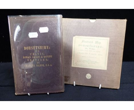
John Claude White "Sikhim & Bhutan Twenty-One Years on the North-East Frontier 1887-1908" First Edition published by Edward Arnold 1909, having green and gilt pictorial cloth boards, having folding map to end of book Note - The author was Sikkim's first Political Officer; he accompanied Younghusband on his mission to Lhasa in 1903-04 and subsequently became Political Officer for Bhutan and part of Tibet.
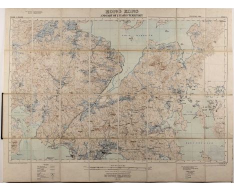
Lot 432
Two sectionalised maps of Hong Kongpublished by the War Office Aug 1905, 71cm x 93cm and a further map published by the War Office Feb.1913 and printed at the Ordnance Survey Office, Southampton, 1913, 75cm x 98cm (2) Provenance:- inherited by the vendor from her grandfather Isaac Day who worked at the University of Hong Kong as an engineering lecturer circa 1918-1938. Some wear and the second map has some discolouring.


Lot 105
Large map being a commemoration of the Centenary of the French Invasion and Surrender , West Wales 1797, this map produced in 1897. Dedicated to the Right Honorable Lord Cawdor, by Thomas Propert. 65x75cm approx. Framed and glazed. Two copies of the same map, one being in poor condition externally. (B.P. 21% + VAT)
Lot 364
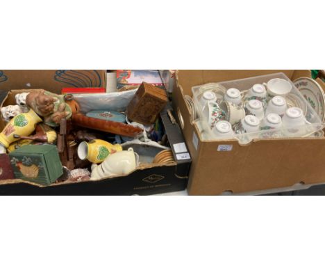
Box of assorted items to include: pottery vases, carved elephant bookends, cowrie shells, wall barometer, sculpture of a horse and figure, pig money box, vintage Rabone Chesterman tape measures, Beswick seated spaniels, Wills's cigarette cards in tin, pipes, pipe rack, boxes, slipware oval trinket tray, map, coasters etc. together with Box of Duchess, Enoch Wedgwood, Pall Mall ware and other 'Indian Tree' design china to include; various plates, bowls, teacups and saucers etc (B.P. 21% + VAT)


Lot 289
Thomson (John). 'A New General Atlas, consisting of a series of geographical designs on various projections, exhibiting the form and component parts of the Globe; and a collection of maps and charts, delineating the natural and political divisions of the empires, kingdoms, and states in the World. Constructed from the best systematic works, and the most authentic voyages and travels. With a memoir of the progress of geography, a summary of physical geography, and a consulting index to facilitate the finding out of places, Edinburgh: Printed by George Ramsay and Company, for John Thomson and Company, Edinburgh; Baldwin, Cradock, and Joy, London; and John Cumming, Dublin, 1817' Condition - some water damage / staining/ spotting/ creasing etc especially to the earlier pages. Later pages/ maps in generally good condition. All maps listed in map index present - Map of Europe -political divisions is loose. Map of England - one the pages is detached and torn. Green boards to cover. Please ask for additional information and photos if required.

Lot 290
Selection of various framed antique maps to include; ‘Map of Northamptonshire’ engraved by J. Cary for John Stockdale 1805 (framed and glazed, 48cm x 43cm), ‘World from the Best Authorities’ engraved by B. Baker (framed and glazed, 31cm x 17cm), ‘Bedfordshire’ by J. Archer (framed and glazed, 19cm x 25cm), ‘Kent’ by John Cary 1793 (unframed, 27cm x 22.5cm), ‘Leicestershire’ by Sid Hall, published by Chapman & Hall 1833 (framed and glazed, 26cm x 20cm). Plus, ‘Northampton Bedfordia, Cantabrigia, Huntingdonia et Rutlandia, Comitatuum Vicinarumb regionum partium adacent’ nouua veraq description Ad 1576’ assumed copy (framed and glazed, 55cm x 40cm). Total six. Buyer must collect or arrange own transportation due to the quantity of fragile glass. (6)

Lot 2048
A rare declassified Operation Desert Storm operations map, sheet 1 from 250700Z, pinpointing situations of allied and enemy forces, printed Feb 1991, 91.5 x 62 cm (posted without frame). folds to map, no apparent water damage/foxing. UK P&P Group 1 (£16+VAT for the first lot and £2+VAT for subsequent lots)

Lot 180
Plastic, rubber, plush and similar children's play figures which includes "Pudsey Bear" plush along with Dinosaur's, Lions and others - see photos. Quantities of smaller figures bagged along with a boxed plywood map jigsaw puzzle "The World". Also a quantity of bagged Lego "Dr Who items. Interesting lot. Conditions appear Fair to Good. (QTY)

Lot 457
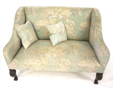
A 20th century sofa and two cushions. Upholstered in fabric printed with a map of the world, raised on carved cabriole supports, H93cm x W133cm x D75cm Condition Report: Generally in good condition. Some small spots of discolouration to the fabric however no significant stains or tears to the fabric. Some signs of wear including scratches and wear to the wood and loose threads to the upholstery, consistent with age and usage. Would benefit from a clean. Structurally sound.


Lot 720
World War Two. Operation Mailfist, a silk map for the proposed invasion of Malaya, 1945, printed with Sheets E & F to recto and verso respectively, 95.5 x 62.5cm, autographed on the reverse by cricketer and footballer Leslie Cromton 1912-1984, brother of the cricketer Dennis Compton (1918-1997), etc., (3) The silk map with established creases and folds, some discolouration in places. Domestic map and autograph OK-good.

Lot 813
Books. One and a half shelves of Derby and Derbyshire interest, 19th c and later, including Glover (Stephen) & Noble (Thomas, editor), The History of the County of Derby, two-volume set, Derby: Henry Mozley and Son, 1829, folding map, later Victorian red cloth, uncut, 8vo, harlequin numbers of The Derbyshire Archaeological Society's Journal and Miscellany, Derby and the Jacobite '45, Ward's Dale Abbey, 1890, original pictorial cloth, disbound, 8vo, Tudor's Duffield Church, 1939, cloth over papered boards, 8vo, The House of Bemrose 1826-1926, 4to, multiple works by Maxwell Craven, etc., mixed sizes


Lot 1678
Ans Wortel (1929-1996)Map met 8 werken, o.a. uit de serie Prent 190. Alle (kleuren)etsen, diverse afmetingen.Prent 190 In 1965 werd Prent 190 opgericht als een verzamelclub voor liefhebbers van hedendaagse grafische kunst. Leden van deze club ontvingen tien keer per jaar een unieke litho, zeefdruk of ets, speciaal vervaardigd voor Prent 190, en altijd in een gelimiteerde oplage van 190 exemplaren.

Lot 6042
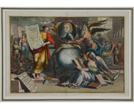
A hand-colored allegorical title page after L. van Vianen (Amsterdam ca. 1660 - after 1726) drawn by Jan Goeree (Middelburg 1670 - 1731 Amsterdam) from: Déscription de l"universe expliquée par Mrs. Sanson et Bion, á Amsterdam chéz F. Halma 1700. In the print we see a globe, oriented towards America, California was still seen as an island. A woman figure holds a map of the Brandenburg region above it, oriented towards Berlin. literature: Shirley, 459.18 x 27 cm.
-
109182 item(s)/page