We found 109182 price guide item(s) matching your search
There are 109182 lots that match your search criteria. Subscribe now to get instant access to the full price guide service.
Click here to subscribe- List
- Grid
-
109182 item(s)/page


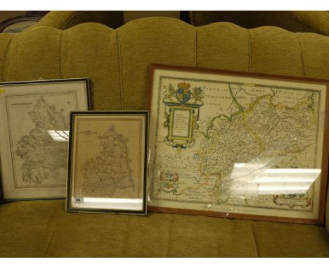
Lot 925
A hand coloured engraved map of Oxfordshire by John Speed with inset town plan of Oxford and 18 heraldic shields in vertical margins. Described with Ye Citie and the Arms of the Colledges of Ye Famous University, pub Thomas Bassett and Richard Chiswell c1676, 395mm x 530mm, mounted framed and glazed


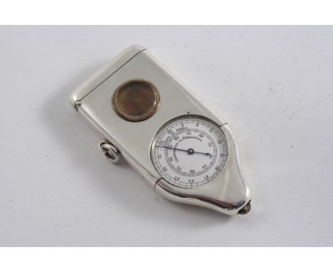
Lot 557
AN EDWARDIAN COMBINED VESTA CASE & MAP MEASURING INSTRUMENT inset with a small compass, the reverse inscribed "he hath smote for us a pathway to the ends of all the earth" & "LW", suspensory ring, Registered Design No. "514307", by Percy Edwards Ltd., London 1907; 3.25" (8.1 cms) long; 2.3 oz gross


Lot 411
Philip II as Caesar. Tetradrachm, 12.19g (7h). Antioch, 244 AD. Obv: MAP IOY?I FI?I??OC KECAP Bare-headed, draped, cuirassed bust right. Rx: ?HMAPX - E?OYCIAC around, S C in exergue, Eagle with spread wings standing right on palm branch, head left, holding wreath in beak. McAlee 1008. Prieur 333 (30 spec.). Mint State

Lot 415
Otacilia Severa. Tetradrachm, 11.61g (12h). Antioch, 244 AD. Obv: MAP OTAKI? CEOVHPAN CEB Draped bust right on crescent, wearing stephane. Rx: ?HMAPX - E?OYCIAC around, S C in exergue, Eagle with spread wings standing left on palm branch, holding wreath in beak. McAlee 1086. Prieur 324 (27 spec.). Some staining on reverse. VF


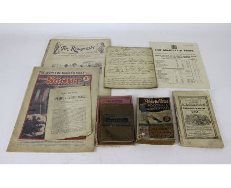
Lot 197
CUNNABELLS NOVA-SCOTIA ALMANAC AND FARMERS MANUAL 1851, (a/f); THE ARMY LIST FOR AUGUST 1843; WALKER (J&C), WILTSHIRE, a folding map, 1836; AB-O'TH'-YATE AND THE OPENING OF THE SHIP CANAL, pamphlet, c1893; HIS MAJESTY'S ARMY, weekly rates of pay pamphlet, 10th November 1914; THE ATHLETIC NEWS FOOTBALL ANNUAL, 1931-32; and four other items (a/f)
![FAULKNER (T), HISTORY AND ANTIQUITIES OF KENSINGTON, xvi [2] 446 [5], engraved frontis, eight plates, map aquatint plate of B](https://cdn.globalauctionplatform.com/1530a7e1-437c-4491-9b83-a405012b6ba4/c3c7e1fa-ea44-4624-a4d6-9ac5a7550b11/468x382.jpg)
Lot 215
FAULKNER (T), HISTORY AND ANTIQUITIES OF KENSINGTON, xvi [2] 446 [5], engraved frontis, eight plates, map aquatint plate of Bayswater Chapel and three pedigree plates, extra illustrated with a typed and annotated page after the map; ¾ leather with marbled boards, London, T. Egerton, 1820 (1)


Lot 500
After Joshua Reynolds (1723-1792). Two mezzotints by John Dean, `Mercury` and `Cupid, in the Character of a Link Boy`, `LONDON, printed for R.SAYER & J.BENNETT, Map & Printsellers, No.53 Fleet Street, as the Act directs, Augt 15, 1777`, 40 x 28.5cm, each in a glazed Hogarth frame. (2) Provenance: Ex Alicia Pearson, Parham Park.


![[TOPOGRAPHY]. SCOTLAND Various, Dumfries-shire, no date [circa 1835]; together with, Peebles, no date [circa 1835], bound as](https://cdn.globalauctionplatform.com/c8e44a30-50a8-4008-bc37-a40200b63128/0b864e9b-5565-4c27-e2db-3da4e7a137e8/468x382.jpg)


Lot 164
A large collection of mainly 19thC book illustrations and engravings, to include Lincolnshire together with Leicestershire and Rutland, ten large lithographs after Charles Wickes, Lincolnshire Churches including Stamford, copper engravings of Stamford and Boston after J.M.W.Turner, Morden's map of Rutland, 1695: The southern counties of England including Berkshire and Surrey, including Windsor Castle, c.1790; a copper engraving of Maidenhead Bridge; bird's eye views of Eton and Winchester Colleges, engravings by Van der Aa and works after Bonington and a map of Buckinghamshire, by Thomas Moule:South West England including Wiltshire and Gloucestershire, including copper engravings after J.M.W.Turner of Battle Abbey, Minehead, comb Martin, Mount Edgcomb and St Michael's Mount, etc; Cirencester after J. Kip, a watercolour of Brixham by Wallis Smith, etc: Antiquarian engravings of Oxford, including Vue d'optique Le College de la Reine de l'Universite s Oxfort, c.1780, a steel engraving of Oxford from Wytham after De Wint and four others. (a quantity)


Lot 16
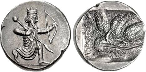
IONIA, Achaemenid Period. Uncertain satrap. Circa 350-333 BC. AR Tetradrachm (22mm, 14.94 g). Persian king, wearing kidaris and kandys, in kneeling-running stance right, holding spear in right hand, bow in left / Incuse rectangle, containing pattern possibly depicting relief map of the hinterland of Ephesos. Johnston, Earliest 12 = BMC Ionia p. 324, 3 (same obv. die); Meadows, Administration 328 var. (legend on obv.); Mildenberg, Münzwesen, Group 6.2; Traité II 77–8 (Memnon of Rhodes); Jameson 1787; Pozzi 3138; Sunrise 70 (this coin). EF, toned, light cleaning marks on obverse. From the Sunrise Collection. Ex Gorny & Mosch 125 (13 October 2003), lot 260.Johnston has interpreted this remarkable reverse design as a relief map of the hinterland of Ephesos, which would make it the earliest Greek map and first physical relief map known. On the right (north) are the mountains Tmolos and Messogis between the river valleys of the Caÿster and Maeander, to the left of which are three mountain ridges (Madranbaba Dagi, Karincali Dagi, and Akaba Tepesi). Johnston follows Six in suggesting that the coins were probably struck under the Persian general Memnon at Ephesos, circa 336-334 BC, in order to pay his army after he had captured the city, but before his defeat by Alexander at the Battle of Granicus in 334. However, Johnston’s theory has been the subject of some doubt, most recently by Leo Mildenberg.

Lot 415
THRACE, Maroneia. Circa 470-450 BC. AR Drachm (14mm, 3.66 g). Forepart of horse left; MAP to left / Quadripartite incuse square. Schönert-Geiss 24–5 var. (unlisted dies); SNG Copenhagen 595; Traité I 1781. VF, deep toning, slight roughness. Very rare. Ex The Numismatic Auction III (1 December 1985), lot 51.

Lot 51
CILICIA, Mallos. Tiribazos. Satrap of Lydia, 388-380 BC. AR Stater (20mm, 10.33 g, 12h). Struck circa 384-383 BC. Baal standing half-left, holding eagle in extended right hand, lotus-tipped scepter in left; MAP to left, TRBZW (in Aramaic) to right / Ahura-Mazda facing, head right, body terminating in solar disk with wings and tail feathers, holding up wreath in right hand, lotus blossom in left. Casabonne Series 1; SNG France 389; SNG Levante 147; Sunrise 40 (this coin). EF, attractively toned, typical die wear. Rare. From the Sunrise Collection.

Lot 603
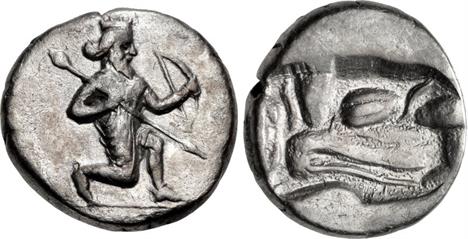
IONIA, Achaemenid Period. Uncertain satrap. Circa 350-333 BC. AR Tetradrachm (23.5mm, 15.19 g). Uncertain mint. Pythagores, magistrate. Persian king, wearing kidaris and kandys, in kneeling-running stance right, holding spear in right hand, bow in left; [?]YTAG-O-P-H[S] around / Incuse rectangle, containing pattern possibly depicting relief map of the hinterland of Ephesos. Johnston, Earliest 1–4 var. (orientation of legend); Meadows, Administration 328 = BMC Ionia p. 323, 1 var. (same); Mildenberg, Münzwesen, Group 6.2, 111 = Pixodarus 1 = Leu 25, lot 165. Near EF, toned, very slight die shift on obverse. Extremely rare, apparently the seventh and finest known, at least four of which are in museum collections (Berlin, London, Munich, and Paris). Johnston has interpreted this remarkable reverse design as a relief map of the hinterland of Ephesos, which would make it the earliest Greek map and first physical relief map known. On the right (north) are the mountains Tmolos and Messogis between the river valleys of the Caÿster and Maeander, to the left of which are three mountain ridges (Madranbaba Dagi, Karincali Dagi, and Akaba Tepesi). Johnston follows Six in suggesting that the coins were probably struck at Ephesos under the Persian general Memnon of Rhodes, circa 336-334 BC, in order to pay his army after he had captured the city, but before his defeat by Alexander at the Battle of Granicus in 334. Some issues have names on the obverse, which Six and Johnston think were city magistrates who authorized some issues for Memnon. However, the theory of Six and Johnston has been the subject of some doubt, most recently by Leo Mildenberg.
Lot 604
IONIA, Achaemenid Period. Uncertain satrap. Circa 350-333 BC. AR Tetradrachm (24.5mm, 15.24 g). Uncertain mint. Persian king, wearing kidaris and kandys, in kneeling-running stance right, holding spear in right hand, bow in left / Incuse rectangle, containing pattern possibly depicting relief map of the hinterland of Ephesos. Johnston, Earliest 5–17; Meadows, Administration 328 var. (legend on obv.); Mildenberg, Münzwesen, Group 6.2; SNG von Aulock 7809; BMC Ionia p. 324, 3 and 6; Hirsch 1528; de Luynes 2902. Near EF, toned, a few light scratches under tone on obverse. Johnston has interpreted this remarkable reverse design as a relief map of the hinterland of Ephesos, which would make it the earliest Greek map and first physical relief map known. On the right (north) are the mountains Tmolos and Messogis between the river valleys of the Caÿster and Maeander, to the left of which are three mountain ridges (Madranbaba Dagi, Karincali Dagi, and Akaba Tepesi). Johnston follows Six in suggesting that the coins were probably struck at Ephesos under the Persian general Memnon of Rhodes, circa 336-334 BC, in order to pay his army after he had captured the city, but before his defeat by Alexander at the Battle of Granicus in 334. Some issues have names on the obverse, which Six and Johnston think were city magistrates who authorized some issues for Memnon. However, the theory of Six and Johnston has been the subject of some doubt, most recently by Leo Mildenberg.

Lot 605
IONIA, Achaemenid Period. Uncertain satrap. Circa 350-333 BC. AR Tetradrachm (21.5mm, 14.75 g). Uncertain mint; De–, magistrate. Persian king, wearing kidaris and kandys, in kneeling-running stance right, holding spear in right hand, bow in left; ?H to left, grain ear to lower right / Incuse rectangle, containing pattern possibly depicting relief map of the hinterland of Ephesos. Johnston, Earliest 30 (same obv. die); Meadows, Administration 328 var. (legend); Mildenberg, Münzwesen, Group 6.2; Traité II 75 (Memnon of Rhodes); BMC Ionia p. 323, 2; Sunrise 71. Good VF, toned, some roughness. From the collection of the MoneyMuseum, Zurich. Ex Leu 76 [Exceptional Private Collection] (27 October 1999), lot 188; Münzen und Medaillen AG 47 (30 November 1972), lot 536.Johnston has interpreted this remarkable reverse design as a relief map of the hinterland of Ephesos, which would make it the earliest Greek map and first physical relief map known. On the right (north) are the mountains Tmolos and Messogis between the river valleys of the Caÿster and Maeander, to the left of which are three mountain ridges (Madranbaba Dagi, Karincali Dagi, and Akaba Tepesi). Johnston follows Six in suggesting that the coins were probably struck at Ephesos under the Persian general Memnon of Rhodes, circa 336-334 BC, in order to pay his army after he had captured the city, but before his defeat by Alexander at the Battle of Granicus in 334. Some issues have names on the obverse, which Six and Johnston think were city magistrates who authorized some issues for Memnon. However, the theory of Six and Johnston has been the subject of some doubt, most recently by Leo Mildenberg.
Lot 606
IONIA, Achaemenid Period. Uncertain satrap. Circa 350-333 BC. AR Drachm (15mm, 3.69 g). Uncertain mint. Persian king, wearing kidaris and kandys, in kneeling-running stance right, holding spear in right hand, bow in left / Incuse rectangle, containing pattern possibly depicting relief map of the hinterland of Ephesos. Unpublished. Near EF, light cleaning marks on reverse. Unique. Johnston has interpreted this remarkable reverse design as a relief map of the hinterland of Ephesos, which would make it the earliest Greek map and first physical relief map known. On the right (north) are the mountains Tmolos and Messogis between the river valleys of the Caÿster and Maeander, to the left of which are three mountain ridges (Madranbaba Dagi, Karincali Dagi, and Akaba Tepesi). Johnston follows Six in suggesting that the coins were probably struck at Ephesos under the Persian general Memnon of Rhodes, circa 336-334 BC, in order to pay his army after he had captured the city, but before his defeat by Alexander at the Battle of Granicus in 334. Some issues have names on the obverse, which Six and Johnston think were city magistrates who authorized some issues for Memnon. However, the theory of Six and Johnston has been the subject of some doubt, most recently by Leo Mildenberg.

Lot 687
CILICIA, Mallos. Circa 440-390 BC. AR Stater (21mm, 11.01 g, 7h). Bearded male deity with four wings facing, holding solar disk before him with both hands; spears(?) diagonally in background / Swan standing left; MAP above wings; all in dotted square within incuse square. Cf. Casabonne Types 1–2; SNG Levante Supp. 22 (this coin), otherwise unpublished. EF, test cut on reverse with corresponding flat area on obverse. Apparently unique. From the Edoardo Levante Collection.

Lot 890
CILICIA, Tarsus. Marcus Aurelius, with Lucius Verus. AD 161-169. Æ (32mm, 18.03 g, 12h). AVT KAIC MAP AVPH?IO ANTON?INOC C?B, laureate head of Marcus right / A?PAINHC TAPCOY MHTPO?O??OC, Marcus, holding volumen in left hand, and Lucius standing facing one another, clasping right hands; star above, OMO/NOIA/ C?BACTON between emperors and continuing into exergue. SNG Levante 1017 (this coin); SNG von Aulock –; SNG France 1452 var. (bust type). VF, dark green patina, light roughness in field before portrait. From the Edoardo Levante Collection.


-
109182 item(s)/page