![Trimmer (Sarah). A Description of a Set of Prints of English History, 2 volumes, London: John Marshall, [between 1808-1828],](https://cdn.globalauctionplatform.com/001257aa-d93a-45da-88a3-abd500ca3cc0/c5b3386f-4ee3-46ba-9f6a-abd600c81137/468x382.jpg)

Trimmer (Sarah). A Description of a Set of Prints of English History, 2 volumes, London: John Marshall, [between 1808-1828], plus [A Series of Prints of English History], [after 1792], together 3 volumes, the 3rd volume with 64 engraved plates but lacking title, some plates dated 1792, 1st two volumes generally toned with occasional minor spotting, all endpapers renewed, uniform contemporary sprinkled calf, rebacked (beige calf), corners recovered, 12mo, together with: Goldsmith (Rev. J.) , A Grammar of General Geography, for the use of Schools and Young Persons, new edition, [1834], engraved frontispiece with volvelle, engraved title toned and nearly detached), 7 folding engraved maps (including double-hemisphere map), some with short closed handling tear, 2 partly detached, 11 engraved plates (most spotted), 4pp. publisher's advertisements at rear (dated 1834), front hinge cracked after title, contemporary reddish-orange morocco, rubbed and marked, spine faded, front cover stamped in gilt, 12mo, plus: Norton (Caroline Sheridan) , Mrs Norton's Story Book: compiled for the amusement of her children, new edition, London: John Harris, 1830, engraved frontispiece and plate, with some spotting and dust-soiling, dampstaining to lower right corners, title dust-soiled, stitching strained, original morocco-backed printed stiff wrappers, spine faded & worn, rear cover somewhat dampstained to lower left corner, slim 8vo, and 15 others antiquarian children's, including a chapbook: The History of Tommy and Harry, York: J. Kendrew, circa 1820 (Qty: 20)NOTESFirst item: Gumuchian 5634 for A Series of Prints of English History, circa 1815 edition ; Osborne pp.174-175 for earlier (?) editions of both titles.
We found 109182 price guide item(s) matching your search
There are 109182 lots that match your search criteria. Subscribe now to get instant access to the full price guide service.
Click here to subscribe- List
- Grid
-
109182 item(s)/page
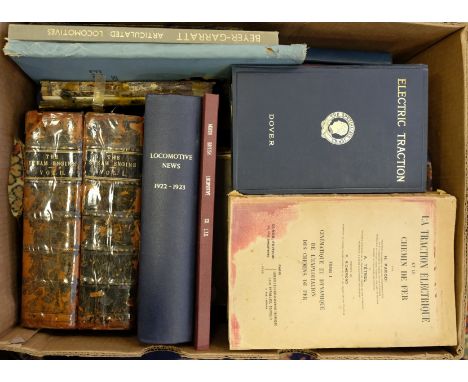
Bradshaw (George). Bradshaw's Continental Railway Guide and General Handbook Illustrated with Local and Other Maps, Special Edition 1875, adverts front and rear, folding map of the Rhine and Switzerland, front pocket containing loose maps of Ghent and Brussels plus another large scale map of parts of France, Switzerland and the Rhine together with Bradshaw's Continental Guide, July 1924 with folding map of Switzerland and loose map of Central Europe together with other related publications mostly late 19th century including Railway Acts, Session of 1874, numbered 26 and 27, several Railway Clearing House maps (3 of Scotland, 1 of England and Wales plus London and its Environs 1913), an Italian Locomotive Works trade catalogue for Societa Italiana Ernesto Bredo 1908, numerous illustrations, large 4to and others (Qty: a carton )

Heylyn (Peter). Cosmographie , In Four Books. Containing the Chorographie and Historie of the World, and all the Principal Kingdoms, Provinces, Seas, and Isles thereof..., and now annexed to this last impression, revised and corrected by the author himself immediately before his death, 3rd edition, London: Printed for Anne Seile, 1666, imprimatur leaf present, engraved additional title, letterpress title in red & black, 4 folding engraved maps (Europe, Asia, Africa, and Americas), with 6 sectional titles (including Appendix), map of Europe with vertical closed tear, cropped at fore-edge & lower edge frayed with loss, map of Asia detached with long vertical closed tear at centre, cropped & frayed to edges with loss, maps of Africa and the Americas with closed tear at foot of central folds, some light dust-soiling & toning, contemporary calf, upper board detached, lower joint split and board loosening, worn, folio (Qty: 1)NOTESWing H1691. Sold with all faults, not subject to return.
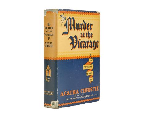
Christie (Agatha). The Murder at the Vicarage, 1st US edition, New York: Dodd, Mead & Company, 1930, village map endpapers, original cloth lettered in green, slight fading at spine ends, dust jacket, unpriced, chips and tears at spine ends and folds, a little toned, lower flap with some marginal fading, 8vo (Qty: 1)NOTESThe first appearance of elderly spinster sleuth Miss Jane Marple.
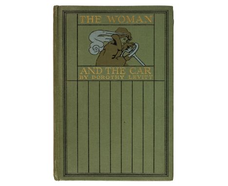
Levitt (Dorothy). The Woman and the Car, A Chatty Little Handbook for all Women who Motor or who want to Motor, 1st edition, London: John Lane, 1909, monochrome frontispiece and plates, scattered spotting, original green pictorial cloth, 8vo, together with, Havilland (Gladys De) , The Woman's Motor Manual, How to Obtain Employment in Government or Private Service as a Woman Driver. All about Motor Driving and the Management of Motor Vehicles, 1st edition, London: Temple Press, 1918, monochrome illustrations, original pictorial boards, 8vo, Bruce (Mrs. Victor A.) , Nine Thousand Miles in Eight Weeks, being an Account of an Epic Journey by Motor-Car through Eleven Countries and Two Continents, 1st edition, London: Heath Cranton Ltd., 1927, monochrome portrait frontispiece and numerous plates, title inscribed by author to verso, map endpapers, original cloth, 8vo, Wyatt (Horace M.) , Alice in Motorland, 2 volumes (series 1 & 2), London: "The Car Illustrated," Ltd., 1904 & 1905, black & white frontispiece and illustrations, some browning, original cloth, some minor marks, small 8vo (Qty: 5)

Ransome (Arthur). 'Swallows and Amazons', 10 titles, 1932-47, comprising Pigeon Post, 1936; We Didn't Mean to Go to Sea, 1937; Secret Water, 1939; The Big Six, 1940; Missee Lee, 1941; The Picts and The Martyrs, 1943; Great Northern?, 1947 all 1st editions, illustrations, map endpapers, light spotting to fore edges, original cloth, dust jackets, a few chips and tears, a little minor spotting, 8vo, together with Swallows & Amazons, August 1932 reprint, Swallowdale, August 1932 reprint, Peter Duck, 4th impression, 1932, and 'Racundra's' First Cruise, 4th impression, 1949 (Qty: 11)

Heylyn (Peter). Cosmographie , In Four Books. Containing the Chorographie and Historie of the World, and all the Principal Kingdoms, Provinces, Seas, and Isles thereof..., and now annexed to this last impression, revised and corrected by the author himself immediately before his death, 3rd edition, London: Printed for Anne Seile, 1666, imprimatur leaf present, engraved additional title (imprint dated 1665), letterpress title in red & black with early ownership inscription, 4 folding engraved maps (Europe, Asia, Africa, and Americas), with 6 sectional titles (including Appendix, loosely inserted section from another copy), map of Europe with vertical closed tears to central fold, few small holes & frayed to edges with some loss (detached), map of Asia bearing imprint 'Henrici Seile, Johan Goddard sculp 1652', slightly cropped to edges (detached), some light dust-soiling, toning and occasional light dampstains to margins, contemporary calf, upper board detached, lower joint split at foot, spine torn with loss, worn, folio (Qty: 1)NOTESWing H1691. Sold with all faults, not subject to return.
![Japanese Land Register. Okinogo, Yamada-gun, Gunma Prefecture, [1883], lithographically printed book from manuscript plans, c](https://cdn.globalauctionplatform.com/001257aa-d93a-45da-88a3-abd500ca3cc0/018b4fb3-4039-48f6-b02d-abd600c5d3cc/468x382.jpg)
Japanese Land Register. Okinogo, Yamada-gun, Gunma Prefecture, [1883], lithographically printed book from manuscript plans, comprising a key leaf and 77 map leaves printed in black, red, blue and green, and 3 end leaves of text printed in black, versos blank, original stab-stitched wrappers with lithographically printed details to upper wrapper (rubbed) and including the stamp of the owner Mr. Nakamura, slightly creased and dust-soiled, oblong folio (33 x 47 cm) (Qty: 1)NOTESThis land register was completed following the Meiji land tax reforms in the 1870s. The Meiji policy led to the abolition of feudal land ownership, provisions for payment of land tax by land owners registered on the land certificate and provision for assessing land tax at 3% of the production value of land. The maps show the addresses and land size and each have a compass and stamp of Mr. Nakamura, while the text leaves give names of people and their responsibilities in the area. Yamada District was formerly a rural district located in Gunma Prefecture and is now entirely part of the cities of Kiryu, Midori and Ota, with a small portion a part of the city of Ashikaga in neighbouring Tochigi Prefecture. The Yamada District was created in 1878 with the reorganisation of Gunma Prefecture into districts. It included some 60 villages which, with the establishment of the municipality system in 1889, was organised into two towns (Kiyru and Omama) and eight villages.

Linschoten (Jan Huygen van). Jan Huygen van Linschoten and The Moral Map of Asia, The Plates and Texts of the Itinerario and Icones, habitus gestusque Indorum ac Lusitanorum per Indiam Viventium, with a study by Ernst van den Boogaart, printed for presentation to the members of The Roxburghe Club, 1999, colour and monochrome plates, printed booklet with colour title contained in pocket at rear, original quarter blue-green Levant morocco, vellum outer tips, gilt printed label to upper cover, large folio (text block 610 x 435 mm, 24 x 17 ins) (Qty: 1)NOTESPrinted in an edition of 300 copies.

Rome. Pianta della Citta di Roma con la indicazione di tutte le antichita e nuovi abbellimenti Rome, Venanzio Monaldini, Libraio e Cartolaro in Piazza di Spagna, 1837, engraved plan of the city of Rome, with partial contemporary hand-colouring, with 16 vignette views of famous buildings to left and right margins, sectionalised on linen, as issued, some marks and light discolouration, detached along folds in several places, with original marbled paper-covered slipcase, with publisher's printed label to upper cover, some wear, overall size 755 x 1115 mm (29.75 x 44 ins), together with: Bordiga (G.). Carta Amministrativa del Regno d'Italia co'suoi stabilimenti politici, militari, civili, e religiosi; e con una parte degli stati limitrofi. Costrutta nel Deposito della Guerra per ordine del Ministro della Guerra, e Marina nell'anno MDCCCXI. Aggiunta e corretta nell'anno 1813, highly-detailed uncoloured engraved map, in 6 sections, sectionalised on linen, some minor discolouration, with original card chemise and publisher's slipcase, with printed label to upper cover, rubbed and some wear, overall size 1335 x 1115 mm (52.5 x 44 ins) (Qty: 2)
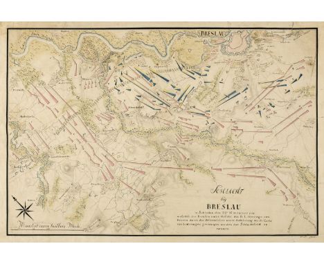
Battle of Breslau. Five engraved battle plans, circa 1757, including Schley (Jacobus van der). Bataille de Breslau Du 22. Novembre 1757..., and Plan de la Bataille de Breslau gagnée par l'Armée Autrtichienne..., 1757, two engraved battle maps, each with contemporary outline colouring indicating the positions of the rival armies, 340 x 460 mm and 360 x 400 mm respectively, together with Weibel (Jakob Samuel). Plan de la Bataille de Breslau en Silesiae..., circa 1790, engraved map with contemporary outline colouring, old folds, 260 x 455 mm, with another unattributed battle plan of Breslau, slight spotting, old folds, 375 x 440 mm, plus Raspe (Gabriel Nikolaus). Grundriss der Stadt Breslau mit der Königl Preuss..., published Nuremberg, 1757, engraved plan with contemporary outline colouring, 205 x 285 mm with Manuscript map. Schlacht bey Breslau in Schlesien den 22tn November 1757..., an unattributed manuscript map of the battle in pen, ink and wash colour, signed 'V. M. 1784' to lower right corner, several repaired marginal closed tears, 320 x 470 mm (Qty: 6)NOTESThe battle of Breslau took place in November 1757 during the 'Seven Years' War' between the Austrian troops under the command of Prince Carl von Lothringen and the Prussian army under the command of the Duke of Bevern. The battle ended in an Austrian victory and the Prussian surrender of Breslau, but in 1763 Silesia was returned to Prussian rule.

Booth (Charles). Descriptive Map of East End Poverty, Compiled from School Board Reports' in 1887, 1st edition, [Macmillan & Co., 1889], lithographic plan, printed in colours, sectionalised on linen, 355 x 485 mm (Qty: 1)NOTESBased on information gathered from School Board visitors, this is the first of Charles Booth's famous poverty maps of London, published in his seminal work Labour and Life of the People, Volume 1: East London (London: Macmillan, 1889). The areas covered include Hoxton, Bethnal Green, Whitechapel, Mile End Road and Limehouse. When the full survey of London was published in 1891, this map was replaced with four maps of the north east, the north west, the south east and the south west of capital together with a key map which encompassed the whole. The four new maps now covered an area from Kensington in the west to Poplar in the east, and from Kentish Town in the north to Stockwell in the south. These maps are collectively known as the Descriptive Map of London Poverty 1889. This earlier map has the same features as the later set, with the streets colour-coded according to the degree of wealth of the inhabitants, ranging from black ('Very poor, lowest class... Vicious, semi-criminal'), through shades of blue and purple ('Poor', 'Mixed', 'Fairly Comfortable'), to red ('Well to do'), but Booth's highest class, yellow ('Wealthy'), does not appear on this map.

* British Isles. De Vaugondy (Robert), Les Isles Britanniques qui comprennent les Royaumes D'Angleterre, D'Ecosse et D'Irlande, Paris, 1754, engraved map with contemporary outline colouring, inset map of the Orkney, Shetland and Faroe Islands, slight creasing, 480 x 590 mm, mounted, framed and glazed, together with Britannicae Insulae in quibus Albion seu Britannia Major et Ivernia seu Britannia Minor..., Paris 1750, engraved map with contemporary outline colouring, slight spotting and dust soiling, 490 x 535 mm, mounted, framed and glazed, with Morden (Robert). Britannia Saxonica [1695 or later], hand coloured engraved map, 370 x 300 mm, mounted, framed and glazed (Qty: 3)
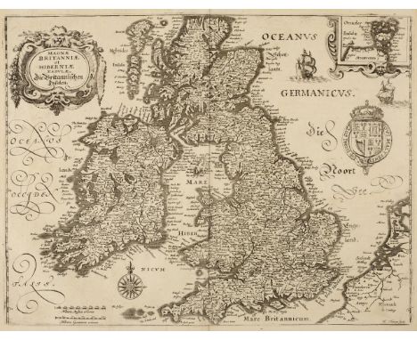
British Isles. Merian ( Matthaus ), Magnae Britanniae et Hiberniae tabulae die Britannischen Insulen, circa 1646, uncoloured engraved map, inset map of the Orkney islands, 275 x 355 mm, together with Weigel (Christopher). Anglia, Scotia & Hibernia cum Insulis vicinis, circa 1710, hand coloured engraved map, large allegorical cartouche surmounted by a portrait of Queen Anne, 275 x 340 mm, with Zatta (Antonio). Britannicae Insulae in quibus Albion seu Britannia Major et Ivernia seu Britannia Minor [and] Li Regni D'Inghilterra e D'Irlanda, Venice circa 1785, two engraved maps with contemporary outline colouring, some soiling to margins, each approximately 310 x 410 mm, plus Kitchin (Thomas). A New and Accurate Map of that District of Great Britain called England & Wales & c. from the latest & most correct surveys, circa 1780, hand coloured engraved map, slight creasing, two repaired marginal closed tears, 395 x 350 mm, with another eleven maps of the British Isles and England & Wales including examples by Morden, Jefferys, Bowen, Kitchen, Guthrie, Bonne and Seale/Tindal, various sizes and condition (Qty: 16)

British Isles. Von Reilly (Franz Johann Joseph), Karte von Gross Britannien und Ireland. Nach Kitchin, Dorret und Jefferys.., 1795, engraved map with contemporary hand colouring, inset map of the Shetland islands, large compass rose and floriate cartouche, 500 x 640 mm, together with De Vaugondy (Robert). Carte des Isles Britanniques, published C. F. Delamarche, Paris, 1804, engraved map with contemporary outline colouring, inset map of the Orkney and Shetland islands, text table in left hand margin, thread margin along upper horizontal border, 535 x 720 mm, with Britannicae Insulae in quibus Albion seu Britannia Major et Ivernia seu Britannia Minor..., circa 1793, hand coloured engraved map, large decorative cartouche, 495 x 550 mm, plus le Royaume D'Angleterre divisé selon les sept Royaumes ou Heptarcie des Saxons..., Paris, 1753, engraved map with contemporary outline colouring, 480 x 525 mm, with another copy of the same map but a later edition, published in Venice by P. Santini in 1778 (Qty: 5)


Barthélemy (Jean Jacques). Travels of Anacharsis the Younger in Greece, during the Middle of the Fourth Century before the Christian Aera..., Translated from the French, 8 volumes (7 text volumes and 1 plate volume), 4th edition, London: J. Johnson, W.J. & J. Richardson, et al., 1806, engraved portrait frontispiece to plate volume, folding engraved map hand-coloured in outline, 35 double-page and 3 single-page maps, plans & plates (few maps hand-coloured in outline), contemporary speckled calf, gilt decorated spines with some labels lacking, spines worn, joints cracked, upper board of plate volume detached, 8vo & 4to (Qty: 8)

* Cambridgeshire. Speed (John), Cambridgshire described with the devision of the hundreds, the townes situation with the Armes of the Colleges of that famous Universiti: and also the Armes of all such Princes and noble-men as have heertofore borne the honorable tytles & dignities of the Earldome of Cambridg., published John Sudbury & George Humble, 1st edition, [1611], hand coloured engraved map, inset town plan of Cambridge, the margins decorated with twenty-four heraldic shields, slight creasing, two pinholes affecting image, central fold strengthened on verso, very slight overall toning, 385 x 530 mm, English text on verso, mounted, framed and double-glazed (Qty: 1)

Universal Magazine. A group of seven maps and plans of Canada, North America and elswhere, taken from the Universal Magazine, 1750s, including A Plan of the City & Fortifications of Louisburg, An Accurate Map of Canada, with the adjacent countries, by R.W. Seale, A New and Accurate Map of the Present War in North America, A New & Correct Map of the Coast of Africa, A Plan of Quebec, A Perspective View of Lake George, An Exact Plan of the Capital City and Port of Malta, several signed R.W. Seale, Plan of Quebec with a little damage to edges and slight loss, Map of North America, torn, but generally without loss to engraved area, plus Swire (William). Manchester and Its Environs, engraved from an actual survey made in 1824, engraved town plan, with inset vignette views, coats of arms, etc., published in the History Directory and Gazetteer of Lancashire by Edward Baines, torn along folds without loss, three smaller town plans of Stockport, Rochdale, Oldham and Ashton-under-Lyne (from the same work), and a printed plan of Peking Legation Quarter 1900-1902, as published in H.B. Morse's International Relations of the Chinese Empire (Qty: 14)NOTESSold with all faults, not subject to return.
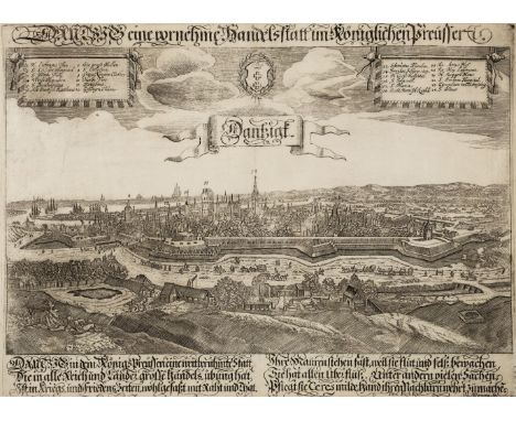
Danzig/Gdansk. Wening (Michael), Dantzig eine vornehme Handelstatt im Koniglichen Preusseri, Nuremberg, circa 1670, uncoloured engraved view of Gdansk after Paul Fürst, two identification keys, repaired closed tears affecting image, margins professionally repaired on verso, 275 x 365 mm, together with an unattributed uncoloured engraved map of the city, 215 x 265 mm, circa 1800, with Leizel (Balthasar Friedrich). Das Recht Städttsche Rath-Haus nebst dem vordern Theil des langen Marckts & Prospect des grünen Thors von der West Seite nebst einen Theil des Langen Marckts zu Danzig, Augsburg, circa 1780, one uncoloured and one coloured engraved vues d’optique, titles repeated in French, one marginal closed tear on the uncoloured example, each approximately 295 x 400 mm, plus Bowyer (R.). Dantzic, 1814, aquatint with contemporary hand colouring, 255 x 330 mm, and Lépine (Francois de). Iconographia Castelli ad Caput Vistulae vulgo Hoft Schantz..., [1696], uncoloured plan of the city and the Vistula river, originally published in 'De rebus a Carolo Gustavo Sveciae', 250 x 315 mm, with Merian (Matthäus). Abbildung der Schwedischen Schantz auff dem Weysselstrom in Preüssen gelegen Anno 1626, uncoloured engraved map of the city, inset map of the eastern Prussian coastline, 235 x 290 mm, with another seven maps and plans of Danzig, including examples by Valegio, 'The Grand Magazine...., publisher, Le Rouge and Bodenhr, various sizes and condition (Qty: 14)

Danzig/Gdansk Homann (Johann Baptist, heirs of), Die Konigl. Polnische u Preusische Hansee - und Handels-Stadt Dantzig, Poln. Gdansko im Lande Pomerellien..., Plan und Prospect..., 1739, engraved city plan with panorama below map, the panorama with later hand colouring, the map with contemporary hand colouring, 495 x 565 mm (Qty: 1)

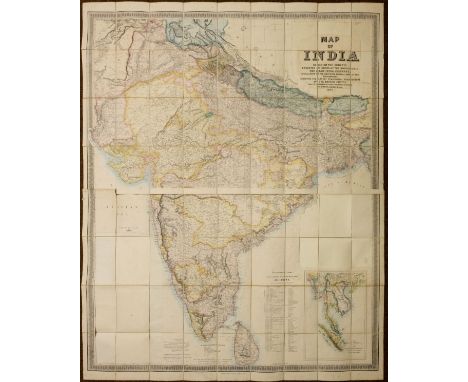
Stanford (Edward, publisher). Map of India, based on the surveys executed by order of the honorable The East India Company, special maps of the surveyor general and other authorities; showing the latest territorial acquisitions of the British Empire and the independent and protected states, railways, canals, &c., 1857, large-scale lithographic map on two sheets, with contemporary outline colouring, inset map of the Malay Peninsula, sectionalised on linen, the title cartouche to upper right excised, and laid back down on later backing paper, with loss of the circular decorative border and similar excision of the three circular distance and bearings charts to lower left and to centre right, overall size 1500 x 1230 mm, contained in contemporary cloth slipcase with printed label to upper cover, rubbed and minor fraying to extremities, some water staining to upper cover (Qty: 1)NOTESSold as seen, not subject to return.

Danzig/Gdansk. Seutter (Mattheus), Dantiscum f Gedanum celeberrimum, spatiosum et munitum Emporium ac Hanseatica Civitas ad Ostia Vistuale in Plonia Borussia in Provincia Pomerellia sita..., Augsburg, circa 1730, engraved city plan with contemporary hand colouring with an uncoloured panorama below the map, identification key showing the fortifications, streets and points of interest, very slight marginal fraying and dust soiling but not affecting image, 495 x 580 mm (Qty: 1)
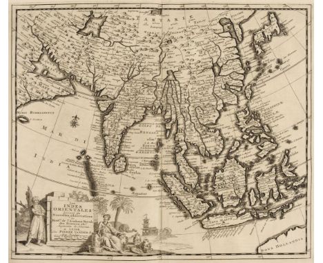
East Indies. Van der Aa ( Pieter ), Les Indes Orientales suivant les Nouvelles Observations..., circa 1720, uncoloured engraved map,decorative cartouche and mileage scale, wide margins, 285 x 340 m (Qty: 1)NOTESDetailed map of South East Asia, Japan, Korea, India and the tip of Australia in the lower right. The map is centered on the Ganges and extends from Japan, the Philippines and the Moluccan Islands to the Persian Gulf and Indian Ocean.
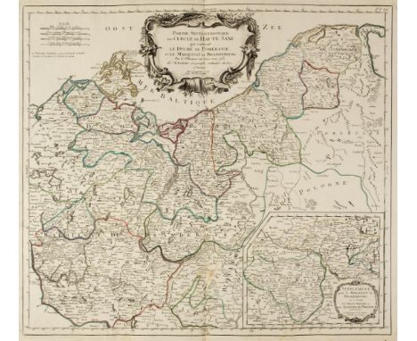
Eastern Europe. De Vaugondy (Robert), Partie Septentrionale du Cercle de Haute Saxe qui contient Le Duché de Poméranie et le Marquisat de Brandebourg..., Venice, circa 1784, engraved map with contemporary outline colouring, inset map of the environs of Brandenburg, large uncoloured floriate cartouche, very slight marginal dust soiling and spotting, 490 x 545 mm, together with Chatelain (Henri Abraham). Nouvell Carte des differents etats du Roi de Prusse et de ceux des autres Princes de la Maison de Brandebourg, Paris, circa 1700, hand coloured engraved map, four small inset maps, 395 x 485 mm, with Von Reilly (Franz Johann Joseph). Das Östliche und Nördliche Europa dritte Einleitungs und Übersichts karte zum ersten Theile des Schauplatzes der fünf Theile der Welt nach und zu Püschings grosser Erdbeschreibung, Vienna, [1791], engraved map with contemporary outline colouring, inset maps of Iceland and Greenland, 240 x 365 mm, plus De La Porte (Joseph). La Russie D'Europe.., Paris, circa 1781, hand coloured engraved map, old folds, 185 x 225 mm, and Desnos (L. C.). Untitled map of Northern Germany, published Paris, circa 1765, engraved map with contemporary outline colouring. old folds, 260 x 430 mm, together with Wilkinson (Robert). Russia in Europe with its Dismemberments from Poland in 1773, 1793 and 1795, published 1799, engraved map with contemporary hand colouring, 320 x 240 mm, with De L'Isle (Guillaume). Nieuwe kaart van Moskovien..., circa 1735, engraved map with contemporary outline colouring, originally published in Johannes Ratelband's 'Geographisch-toneel of uitgezochte kaarten tot gemak der Officieren, Reisigers en Liefhebbers', old folds, 180 x 260 mm, plus Cluver (Philipp). Cellarij Germania Antiqua, [1711- 1717], hand coloured engraved map, originally published in the 'Atlas Geographus', old folds, 205 x 310 mm, and Bonne (Rigobert). Untitled map of North West Germany, Paris [1776], engraved map with contemporary outline colouring, slight dust soiling, 305 x 485 mm, with Zatta (Antonio). Governi di Moscovia E Woronez colle loro Provincie Nella Russia Europea di nuova projezione, Venice, 1782, engraved map with contemporary outline colouring, 435 x 345 mm, and Cellarius (Christophorus). Germania Antiqua, [1770], hand coloured engraved map, 315 x 465 mm (Qty: 11)
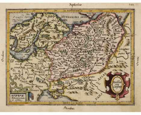
Eastern Europe. Mercator (Gerard & Hondius Henricus ), Russia cum Confinijs circa 1610, hand coloured engraved miniature map, near contemporary manuscript page number and cardinal directions added to the blank margins, 140 x 185 mm, Latin text to verso, together with Hondius (Jodocus). Taurica Chersonesus, [1625], hand coloured engraved map, originally published in Samuel Purchas's 'Purchas his Pilgrimage', map size 130 x 165 mm, English text above and on the verso, with Du Val (Pierre). Carte du Voyage de Moscovie Selon la Relation d'Olearius, Paris circa 1665, uncoloured engraved map detailing the route of Adam Olearius's travels from Moscow to the Baltic, 160 x 230 mm, plus Briet (Philip). Sarmatiae Europae ae Delineatio, Paris {1653], hand coloured engraved map, originally published in 'Theater geographique de l'Europe' , a scarce work which highlights the contribution of the Jesuit missionaries to geographical discoveries, 150 x 190m mm, and Mercator (Gerard & Jansson Jan). Livonia, published Amsterdam, circa 1630, hand coloured engraved map originally published in the 'Atlas Minor', slight dust soiling and text showthrough, 150 x 190 mm, German text on verso, together with Mercator (Gerard & Hondius J.). Livonia, Amsterdam, circa 1608, engraved map with contemporary outline colouring, 150 x 190 mm, French text on verso, supplied with an additional sheet of descriptive text, with Rosaccio (Giuseppe, publisher). Untitled map of central Europe, circa 1688, uncoloured woodblock map of central Europe with Prague at its centre, originally published in 'Teatro del mondo e sue parti cioe Europa, Africa, Asia et America', this new edition had larger woodblock maps cut by Giuseppe Moretti and stretched from Moscow in the east to Venice in the South, left hand vertical margin frayed with slight loss to to neatline, margin extended, 130 x 170 mm, plus Eichovius (Cyprianus). Livoniae descrip. published Cornelius Sutorius [1604], scarce uncoloured engraved map originally published in the 'Delitiarum Germaniae...,' , 90 x 120 mm, and Olearius (Adam). D. D. Joanni Berkenhead..., A New Map of Liefland, [1656], uncoloured engraved map of the Eastern coast of the Baltic, old folds, slight creasing, margins repaired and strengthened on verso, occasional repaired marginal closed tears, one repaired rust hole affecting image, 290 x 360 mm, with Mare Balthicum oder Ost See, [1656], uncoloured engraved map of the Baltic, originally published in Adam Olearius's 'Vermehrte Bewe Beschreibung', map size 110 x 155 mm with German text above, below and on verso of map (Qty: 10)

* Eastern Europe. Moll (Herman), To His Most Serene and August Majesty Peter Alexovitz Absolute Lord of Russia &c. This Map of Moscovy, Poland, Tartary and ye Black Sea &c. is most Humbly Dedicated, London: J. Bowles, P. Overton. T. Bowles & J. King, circa 1730, engraved map with contemporary outline colouring and some later enhancement, inset maps of Northern Russia, the lower course of the River Volga and the vicinity of Asov, large allegorical cartouche, old folds, some folds show areas of repair, one small area of loss in publisher's details, skilfully repaired and replaced in facsimile, 610 x 980 mm, mounted, framed and glazed (Qty: 1)NOTESOriginally published in The World Describ'd.

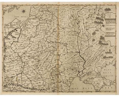
* Eastern Europe. Munster (Sebastian), Landtafel des Ungerlands, Polands, Reussen, Littaw, Walachen und Bulgaren, [1550 and 1588], woodblock map with contemporary hand colouring, 320 x 365 mm, mounted in a double-aperture mount with another slightly later example (Qty: 1)NOTESThe map shows Poland and Russia in the North, including the Ukraine, Serbia, the Black Sea and River Danube. It is centred on Poland and Lithuania and was published in Munster's 'Cosmographia'.

Europe. Van de Aa (Pieter), L'Europe suivant les Nouvelles Observations..., Leiden, circa 1714, hand coloured engraved map, slight staining and creasing, 230 x 305 mm, together with Lotter (Tobias Conrad), Europa...., Augsburg, circa 1750, hand coloured engraved map, 200 x 260 mm, with Ortelius (Abraham). Europa, published Michael Coignet, Antwerp, circa 1601, engraved minature map with contemporary outline colouring, thread margins strengthened on verso, 85 x 120 mm, French text on verso, plus Botero (Giovanni). Europa, Venice [1598], uncoloured engraved miniature map, Italian text above, below and on verso of map, map size 75 x 105 mm (Qty: 4)
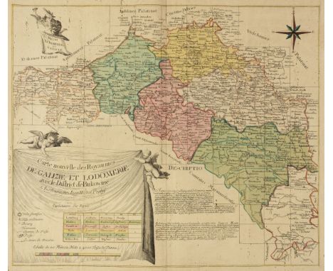
Galicia. Probst (Jean Michael), Carte nouvelle des Royaumes de Galizie et Lodomerie avec le District de Bukowine, Augsburg, circa 1780, engraved map with contemporary hand colouring, large 'curtain' cartouche supported by two putti, slight worming and spotting, old folds, 495 x 575 mm, together with Homann (Johann Baptist, heirs of). Lubomeriae et Galliciae Regni Tabula Geographica, 1775, engraved map with contemporary hand colouring, several holes affecting image crudely repaired on verso, some creasing and spotting, trimmed to neatline, 450 x 590 mm, with Maire (F. I., publisher). Carte des deux Cercles de Brody et Brzeczany Karte deren zween kreisen von Brody und Brzeczany, Vienna, circa 1790, engraved map with contemporary outline colouring, originally published in 'Atlas des Roiaumes de Galicie et de Lodomerie consistant en une Carte générale de ces deux Roiaumes et 10 Cartes...,', large margins, 610 x 430 mm, plus Metzburg (G. I. & Zannoni Rizzi). West Galizien 1tes Blatt enthaltend den Krakauer, Slomniker, Stopnicer, Sandecer, Bochnier und Myslencier Kreis..., West Galizien IItes Blatt enthaltend den Konskier, Radomer, Jozefower und Opatower Kreis..., West Galizien IIItes Blattenthaltend den Wiazowner, Siedlcer, Bialer, Chelmer und Lubliner kreis..., [and] Ost Galizien zweites Blatt, enthaltend den Zamoscer, Zolkiewer und Przemysler kreis..., published Vienna, 1803, together four engraved maps with sparse contemporary outline colouring, each map edged with pink silk and laid on canvas, old folds, each with a contemporary manuscript label to verso, each approximately 480 x 590 mm, and Ost Galizien IVtes Blatt enthaltend den Stanislawower, Zaleszyker und Tschernowitzer kreis..., Vienna, 1803, engraved map with contemporary outline colouring, 490 x 595 mm (Qty: 8)

* Germany & Poland. Berey (Nicolas & Tassin Christopher, publishers), Carte des Duches de Saxe Meklembourg, Pomeranie, Prusse et Marquisat de Brandenbourg, Paris, circa 1640, hand coloured engraved map of North-western Ge rmany and what would become Poland, old folds, 365 x 510 mm, mounted, framed and glazed (Qty: 1)NOTESUncommon.

Germany & Poland. Sanson (N.), Téatre de la Guerre des Couronnes du Nord, publsihed Pierre Mortier, Amsterdam, circa 1690, engraved map, engraved by Johannes Van Luchtenburgh, contemporary outline colouring, large uncoloured cartouche, additional title in French above map, several marginal closed tears, some oxidisation to old watercolour causing cracking and splitting to map, slight marginal water staining, 465 x 585 mm (Qty: 1)

Germany/Prussia. Halma (Francois), Regni Borussiae et Electoratus Brandeburgici, Ceterarumque, Quae Friderici, Regis Boruss. sceptro reguntur, nec non finitimarum Provinciarum Delineatio, ad Stationes Publicorum Cursuum et Veredariorum, quae ultra c c mill. Germ. in longitudinem patent, cognoscendas accommodata. quasque Vtilitati Publicae institutas, Ejusdem Regis Aug. auspiciis, hereditario Jure, moderatur et regit Vir Illmus. Joannes Casimirus. S.R.I. Comes A Wartenberg. Reg. Majest. Borussor Supremus Camerarius et Minister Status Primarius etc. etc. Amsterdam, circa 1700, engraved map with contemporary outline colouring, large uncoloured cartouche of a coach and horses and a mail horseman, table of explanation and a large Brandenburg/Prussian coat of arms, old fold professionally repaired on verso, 525 x 685 mm (Qty: 1)NOTESA rare map showing the postal routes of Prussia. Centred on Berlin it shows the postal routes between East Prussia (Memel) and the Lower Rhine, including connecting routes to southern Germany, Lake Constance and to Vienna and to the east the route to Warsaw and Koenigsberg and to the west as far as Amsterdam. The map was re-issued by P. Schenk a few years later with the addition of his imprint.

* Gloucestershire. Speed (John), Glocestershire contrived thirty thre severall hundreds and those againe into foure principall devisions. The citie of Glocester & Bristowe discribed with the armes of such noble men as have bene dignified with ye titlled of Earles & Dukes thereof, published Thomas Bassett & Richard Chiswell, [1676], hand coloured engraved map, inset town plans of Gloucester and Bristol, some creasing, 385 x 510 mm, mounted, framed and glazed (Qty: 1)
Greenwood (C. & J.). A collection of eleven county maps, circa 1830, engraved maps, eight with contemporary hand colouring, some toning and staining, one map trimmed to neatline and crudely re-margined with later paper, some marginal chipping and tears with occasional loss, one laid on hardboard, occasional duplicates, each approximately 585 x 700 mm, together with Hodgson (Thomas). Plan of the County of Westmorland, Describing minutely the Boundaries of Wards, Parishes, and Townships ... Turnpike, Carriage, Bridle and Roman Roads, also the Positions of Towns, Villages, Seats & Farm Houses, Commons, Parks, Woods, Lakes, Mountains, &c. &c. 1828, uncoloured engraved large scale map, vignettes of Appleby and Lowther castles, calligraphic title, table of explanation, list of the heights of mountains and the depths of Lakes, compass rose and mileage scale, the map is cut into four parts, each laid on card and then the whole on to hardboard, the board is bowed, printed surface creased, dust soiled and frayed with areas of loss to the margins and upper left and right corners, 1390 x 1600 mm (Qty: 12)NOTESThe Greenwood maps comprise of :- Cheshire, Nottinghamshire, Warwickshire, Cumberland, Staffordshire, Westmorland, North East Circuit of Wales, The North West Circuit of Wales, Monmouthshire and Worcestershire (2 copies).
![Hevelius (Johannes). Cepheus, published Dantzig, [1687], hand coloured engraved constellation map originally published in 'Fi](https://cdn.globalauctionplatform.com/001257aa-d93a-45da-88a3-abd500ca3cc0/c086aa4e-ca23-443c-b3eb-abd600c66f98/468x382.jpg)
Hevelius (Johannes). Cepheus, published Dantzig, [1687], hand coloured engraved constellation map originally published in 'Firmamentum Sobiescianum sive Uranographia', two repaired closed marginal tears, one of which affects the printed surface, 300 x 375 mm (Qty: 1)NOTESJohannes Hevelius (1611 - 1687) was a Protestant councilor and mayor of Danzig, in the Polish-Lithuanian Commonwealth. As an astronomer he gained a reputation as "the founder of lunar topography" and described ten new constellations, seven of which are still recognized by astronomers. The 'Firmamentum...,' was the first star atlas to rival Bayer's Uranometria in accuracy, utility, innovation, and influence. Hevelius was highly inovative in the way that he illustrated the constellations in that they were depicted as they would appear on a globe, rather than from a geocentric point of view,
* Maps and prints. A collection of six engraved maps and prints, mostly 19th century, including Brion de la Tour (Louis). L'Angleterre divisée en 5 grandes parties subdivisées en 52 Comtés..., Paris, 1766, hand coloured engraved map with an elaborate floriate border, slight dust soiling, 265 x 310 mm, mounted, framed and glazed, together with Ramble (Reuben). Middlesex [and] Lancashire [1845], two hand coloured engraved maps with the margins decorated with coloured lithographic topographical vignettes, each approximately 205 x 160 mm, uniformly mounted, framed and glazed, with Knight (C. & Merke H.). Outside a Cottage in Buckinghamshire, published Edward Orme,1807, aquatint with contemporary hand colouring, 245 x 320 mm, mounted, framed and glazed plus De Loutherbourg (P.). Peaks Hole Derbyshire, R. Bowyer, 1805, aquatint with contemporary hand colouring, 270 x 325 mm, mounted, framed and glazed, and Pratt (Henry). To the Revd. J. H. Gwyther A. M. Vicar. This print of Madeley Vicarage, Church and School is most respectfully dedicated..., Henry Pratt, Madeley, 1848, lithograph with contemporary hand colouring, trimmed to image with 'dropped mount' to show title, image size 260 x 375 mm, mounted, framed and glazed (Qty: 6)

* Nottinghamshire. Speed (John), The Countie of Nottingham described, the Shire Townes situation and the Earls there of observed, John Sudbury & George Humble, [1627], hand coloured engraved map, inset town plan of Nottingham, slight spotting, central fold partially split, 380 x 510 mm, framed and double-glazed, English text on verso, together with Blaeu (Johannes). Comitatus Nottinghamiensis Nottingham Shire, Amsterdam, [1645 or later], engraved map with contemporary hand colouring, 390 x 500 mm, Latin text on verso with Schenk (P. & Valk G.), Comitatus Nottinghamiensis sive Nottinghamshire, Amsterdam, circa 1720, engraved map with contemporary hand colouring and some later enhancement, very slight spotting, largely confined to margins, 375 x 475 mm, framed and glazed, plus Ramble (Reuben). Nottinghamsh. circa 1845, uncoloured engraved map with the margins decorated with coloured lithographic topographical vignettes, 195 x 155 mm, mounted, framed and glazed (Qty: 4)

Nowa Marchia/Poland. Sotzmann (D. F.), Special Karte von der Neumark..., published Simon Schropp & Comp, Berlin, 1811, engraved map with contemporary outline colouring, title repeated above map in French, old folds, 850 x 715 mm, together with Güssefeld (Franz Ludwig). Charte von der Neumark die ursprünglichen Kreise derselben vorstelland..., published Homann heirs, Nuremberg, 1796, engraved map with contemporary outline colouring, old folds, narrow margins, 465 x 555 mm, with Cassini ( Giovanni Maria). La Parte Settentrionale del Circolo Dell' Alta Sassonia..., Rome, 1796, engraved map with contemporary outline colouring, 365 x 490 mm, plus Stockdale (John). Untitled map of Northern Poland, 1800, engraved map with contemporary outline colouring, almost certainly a single sheet from a larger wall map, 605 x 705 mm (Qty: 4)

Ogilby (John). The Road from London to Newhaven com Sussex..., continued from Newhaven to New Shoreham com Sussex, circa 1680, hand coloured engraved strip road map, some marginal fraying and loss but not affecting image, slight creasing and spotting, 335 x 430 mm (Qty: 1)NOTESThis is sheet number 29. It commences in London and runs through Streatham, Croydon, East Grinstead, Lewes and ends at Newhaven and then continues from Newhaven through Brighton to New Shoreham

Ogilby (John). The Road from London to St Davids in com. Pembroke, circa 1675, hand coloured engraved strip road map, 305 x 450 mm, mounted (Qty: 1)NOTESThe road commences at London and passes through Brentford, Hounslow, Colebrook, Maidenhead, Henley on Thames, Nettlebed and Dorchester and ends at Abingdon
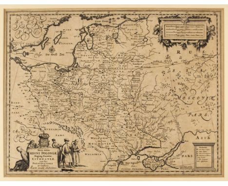
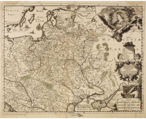
* Poland. Allard (Hugo), Nova Totius Regni Poloniae, Magniq. Ducatus Lithuaniae, cum suis Palatinatibus ac Confinis, published Amsterdam by Guillaume Le Vasseur de Beauplan, circa 1660, uncoloured engraved map, decorative cartouche and mileage scale, slight overall toning 390 x 510 mm, mounted, framed and glazed (Qty: 1)

Poland. Blaeu (J.), Ducatus Oswieczensis et Zatoriensis, Amsterdam circa 1670, engraved map of Southern Poland with bright contemporary hand colouring, large margins, slight fraying at base but not affecting image, 420 x 520 mm, Spanish text on verso, together with Sanson (Nicolas). Haute ou Petite Pologne ou sont les Palatinates de Cracow, Sandomirie et Lublin, Paris, 1666, engraved map with contemporary outline colouring, some creasing, map trimmed to neatline and laid on contemporary paper, 430 x 560 mm, with Santini (P.). Carte de la Pologne Autrichienne contenant La Russie Rouge...., Dressée sur l'exemplaire des Heritiers Homann, published Venice, 1775, engraved map with contemporary outline colouring, large uncoloured cartouche and table of explanation, some damp staining and loss to lower corners but not affecting image, 460 x 595 mm, plus Zatta (Antonio). Li Palatinati di Cracowia, Lekzyca, Sieradz, Sandomir E Lublino..., Venice, 1781, engraved map with contemporary outline colouring, 325 x 420 mm, and Botero (Govanni). Oswiec et Zatorien ducatus, [1599], uncoloured engraved miniature map, Italian text above, below and on verso of map, map size 80 x 105 mm, with Bertius (P.). Oswieczimensis et Zatoriensis Ducat, Amsterdam [1616], hand coloured engraved miniature map, one worm hole affecting image, slight text showthrough, 95 x 135 mm, Latin text on verso, with another earlier uncoloured version of this map published by Barent Langenes in the 1598 edition of Langenes's 'Caert-Thresoor', one worm hole affecting image, German text on verso (Qty: 7)
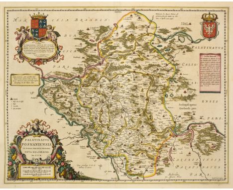
Poland. Blaeu (Johannes), Palatinatus Posnaniensis, in Maiori Polonia Primarii nova delineatio. per G. F. M. Amsterdam, circa 1670, engraved map with contemporary hand colouring, large floriate cartouche and mileage scale, 420 x 530 mm, Spanish text on verso, together with Ducatus Silesiae Giogani vera delineatio, Amsterdam circa 1640, engraved map with contemporary outline colouring, decorative strapwork cartouche and table of explanation, 425 x 510 mm, Latin text on verso (Qty: 2)
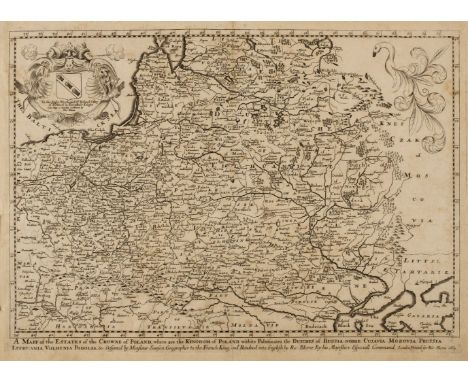
Poland. Blome (Richard), A Mapp of the Estates of the Crowne of Poland, where are the Kingdom of Poland withits Palatinates, the Dutches of Russia-Noire, Cujavia, Mozovia, Prussia, Lithuania, Volhynia Podolla &c. Designed by Monsieur Sanson Geographer to the French King and Rendered into English by Ric: Blome..., 1669, uncoloured map engraved by Francis Lamb with the title printed below the map, the cartouche containing a dedication to Sir Richard Otley of Pichford in Shropshire, slight staining, some marginal fraying, 285 x 405 mm, (Qty: 1)NOTESA scarce map of Poland and the first folio sized map to be engraved in England, John Speed's map being engraved in Amsterdam. Blome's atlas the 'Geographical Description of the Four Parts of the World' was a small folio volume containing twenty-four maps engraved by Francis Lamb, Thomas Burnford and Wenceslas Hollar. Blome was handicapped by the lack of a domestic mapmaking environment comparable with that in Europe and to finance his work he took on subscribers, who in exchange for an advance had their coat of arms added to certain maps.

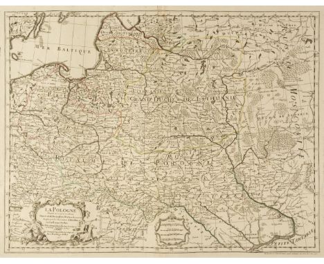
Poland. Danckerts (Justus), Regni Poloniae et Ducatus Lithuaniae, Voliniae, Podoliae, Ucraniae, Prussiae et Curlandiae..., Amsterdam circa 1700, engraved map with contemporary outline colouring, with additional contemporary underlining of regions and towns, some marginal worming but not affecting image, small margins, 505 x 585 mm, together with Homann (Johann Baptist). Regni Poloniae Magnique ducatus Lithuaniae nova et exacta tabula..., Nuremberg, 1739, engraved map with contemporary hand colouring 485 x 545 mm, with De L'Isle (Guillaume). La Pologne dres ée sur ce qu'en ont donn é Starovolsk , Beauplan , Hartnoch et autres autour ..., Paris, 1796, engraved map with contemporary outline colouring and some later enhancement to the cartouche, 485 x 625 mm (Qty: 3)
Poland. De L'Isle (Guillaume), La Pologne Dressée sur ce qu'en ont donné Starovolsk, Beauplan, Hartnoch et autres..., Paris, 1703, engraved map with contemporary outline colouring, uncoloured decorative cartouche and mileage scale, 490 x 635 mm, together with another example with later outline colouring and several areas of damage, crudely repaired (Qty: 2)
Poland. Gastaldi (Giacomo), Il vero disegno della seconda parte dil Regno di Polonia, Venice, 1568, uncoloured map, engraved by Paolo Forlani, trimmed to just inside neatline and re-margined, 380 x 495 mm (Qty: 1)NOTESA scarce and early map of Poland which includes Ukraine and the Crimea. This is the 'southern half' of a two sheet map, the northern half having the title 'Il Disegno de Geografia Moderna del Regno di Polonia, e Parte del Ducado di Moscovia, con parte della Scandia, e parte de Suevia, con molte Regioni, in quelli.'. The map is widely regarded as the first Lafreri map to focus on Poland.

Poland. Jansson (Jan), Novissima Poloniae Regni Descriptio , Amsterdam, circa 1660, engraved map with contemporary outline colouring, trimmed to neatline with margins professionally restored, 425 x 530 mm, no text on verso, together with Du Val (Pierre). Carte de Pologne et des Estats qui en dependent, Paris, circa 1665, engraved map with contemporary outline colouring, two wormholes to margins but not affecting image, 380 x 530 mm (Qty: 2)

Poland. Jansson (Jan), Poloniae nova et Acurata descriptio, published Amsterdam, circa 1638, engraved map with contemporary outline colouring, slight soiling largely confined to margins, short split at base of central fold, 395 x 510 mm, German text on verso, together with another uncoloured example with no text to verso (Qty: 2)

* Poland. Jansson (Jan), Silesia Inferior..., Amsterdam, circa 1647, engraved map after J. Scultetus, contemporary hand colouring, 420 x 510 mm, with another similar example with a repaired closed tear, mounted, with Blaeu (J & G). Sileasia Inferior..., engraved map with contemporary outline colouring with another similar example but with some staining, presented in a four aperture mount, framed and glazed (Qty: 1)

* Poland. Jansson (Jan), Tractuum Borussiae, circa Gedanum et Elbingam, ab Incolis Werder Appellati, cum Adiuncta Neringia, Nova et Elaboratissima Delineatio..., Amsterdam, circa 1650, three copies of the same engraved map with contemporary hand colouring, including one later edition with the Petrus Schenk & Gerard Valk imprint of circa 1705, orientated to the east, occasional spotting, each 415 x 480 mm, triple aperture mount, framed and glazed (Qty: 1)

Poland. Rossi (Giacomo), Stati Della Corona di Polonia divisia nell sue principali Provincie e Palatinati, Rome, 1678, engraved map with contemporary outline colouring, central fold creased and split at base and repaired on verso, 430 x 570 mm, together with Nolin (J. B.). Le Royaume de Pologne comprenant les etats de Pologne et de Lithuanie divisez en Provinces et sudivisez en Palatinats..., Paris, 1697, engraved map with contemporary outline colouring, trimmed to neatline with slight loss, some marginal closed tears and fraying resulting in a small area of loss to the upper right corner, crudely repaired, old fold repaired on verso, 470 x 595 mm, with Bouttats (Gaspar). Polonia Regnum, Antwerp circa 1670, uncoloured engraved map, originally published in G. Gualdo Priorato's 'Historia di Leopoldo Cesare', trimmed to plate mark on three margins, old folds, 340 x 435 mm (Qty: 3)

Poland. Sadebeck (August Friedrich pseud. Sirisa ), Polens Ende durch die letzen Theilungen und Besitznehmungen in den Jahren 1793 und 95 Preussen, Russland, Oestreich, 1795, engraved map with contemporary hand colouring, three boxes of descriptive text, old folds, 535 x 600 mm (Qty: 1)NOTES'Poland's End' is a rare map showing the country and its partition and the divisions and possessions of Russia, Prussia and Austria, with the respective areas outlined in red with the dates (1773, 1793 & 1795). It is not found in Imago Poloniae or in the 'Malinowski collection of the maps of Poland'
Poland. Sandrart (Jacob), Nova totius Regni Poloniae Mangique Ducatus Lituaniae cum suis Palatinabus Ac Confiniis Exacta Delineatio per G. Le Vasseur de Beauplan, Nuremberg, [1675], engraved map with contemporary outline colouring, one printer's fold, slight marginal staining, occasional pin holes affecting image, 410 x 520 mm (Qty: 1)NOTESA rare map of Poland and Lithuania. The map is dominated by a portrait of King Johannes III Sobieski depicted as a Roman emperor. The second edition of the map which was published in 1697 has a portrait of King Augustus II (Augustus the Strong) who came to the throne in that year following Sobieski's death. The map is based upon the work of Guillaume Levasseur de Beauplan (1600-1673), a French mapmaker, engineer and architect. Beauplan served as artillery captain for the army of the Crown of the Kingdom of Poland between 1630 and 1648 and in 1639, he created the first accurate map of Ukraine, a map regarded as one of the most important in Poland's cartographic history. We can only find one record of Sandrart's map appearing in auction in the last ten years (Zisska & Schaer, 2013, Sale 62, Lot 3162 ) where it sold for 4,284 Euros including premium.

Poland. Visscher (Nicholas), Haec Tabula nova Poloniae et Silesiae, Amsterdam, 1630, hand-coloured 'carte des figures' map engraved by A. Goos, with 2 oval panoramas of Krakow and Danzig (Gdansk) along the upper margin, 8 costumed figures to the vertical margins, portraits of Kings in each corner and a further 4 oval vignettes of principal cities to the lower horizontal margins, trimmed to neat line and laid on later paper, old folds, 465 x 530 mm (Qty: 1)
-
109182 item(s)/page