Van Langeren (Jacob). A collection of 36 maps, originally published in 'A Direction for the English Traveller...,' [1643], uncoloured engraved miniature maps, set into the lower right corner below a triangular mileage table, slight spotting, the map of Hampshire with marginal water staining, a contemporary ink manuscript title on the verso causing slight show through, each approximately 105 x 105 mm, apart from the map of Wales which measures 230 x 210, together with the title page and directions for using the mapsQty: (36)NOTESThe maps comprise:- Wales, Lancashire, Hampshire, Dorset, Gloucestershire, Devon, Middlesex, Cheshire, Suffolk, Somerset, Essex, Oxford, Sussex, Cornwall, Berkshire, Warwickshire, Worcestershire, Buckinghamshire, Lincolnshire, Herefordshire, Westmorland, Huntingdon, Cumberland, Cambridge, Durham, Derbyshire, Staffordshire, Nottinghamshire, Wiltshire, Hertfordshire, Leicestershire, Shropshire, Northamptonshire, Bedfordshire, Northumberland and Norfolk.


![Poland. Speed (John), A Newe Mape of Poland, Thomas Bassett & Richard Chiswell, [1676], hand-coloured engraved 'carte-a-f](https://cdn.globalauctionplatform.com/773a2f63-986c-4cc6-9db3-ad1200b50a92/f4313dd3-e906-4931-9f52-ad130125c947/468x382.jpg)
![Russia. Speed (John), A Map of Russia, Thomas Bassett & Richard Chiswell, [1676], hand-coloured map engraved by Francis L](https://cdn.globalauctionplatform.com/773a2f63-986c-4cc6-9db3-ad1200b50a92/82a43768-a202-4941-a657-ad130125c9de/468x382.jpg)


![Scotland. Ortelius (Abraham), Scotiae Tabula, [1584], uncoloured engraved map orientated to the west, large strapwork cartouc](https://cdn.globalauctionplatform.com/773a2f63-986c-4cc6-9db3-ad1200b50a92/4f47aee2-36fb-4b20-a205-ad130125cd3b/468x382.jpg)


![Tartary. Speed (John), A Newe Mape of Tartary, Thomas Bassett & Richard Chiswell [1676], hand-coloured engraved carte-a-f](https://cdn.globalauctionplatform.com/773a2f63-986c-4cc6-9db3-ad1200b50a92/53e878d9-415a-4d3b-82e4-ad130125d1e7/468x382.jpg)
![Van Langeren (Jacob). A collection of 36 maps, originally published in 'A Direction for the English Traveller...,' [1643], un](https://cdn.globalauctionplatform.com/773a2f63-986c-4cc6-9db3-ad1200b50a92/33f49505-d233-45cc-8dd3-ad130125d281/468x382.jpg)

![Wales. Ortelius (Abraham & Lhuyd Humphrey), Cambriae Typus Auctore Humfredo Lhuydo Denbigiense Cambrobritano [1608- 12],](https://cdn.globalauctionplatform.com/773a2f63-986c-4cc6-9db3-ad1200b50a92/01a8a889-57a8-4596-b4c2-ad130125d3dc/468x382.jpg)
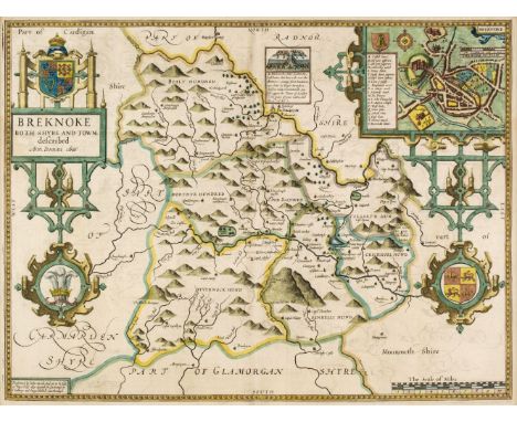
![* Wales. Speed (John), Wales, John Sudbury & George Humble, [1616], hand-coloured engraved map with inset vignettes of Ba](https://cdn.globalauctionplatform.com/773a2f63-986c-4cc6-9db3-ad1200b50a92/72808b51-698a-411f-92da-ad130125d538/468x382.jpg)


![World. Ortelius (Abraham), Aevi Veteris Typus Geographicus, [1601 - 12], engraved map of the 'old world' with contemporary ha](https://cdn.globalauctionplatform.com/773a2f63-986c-4cc6-9db3-ad1200b50a92/3facd471-33b0-4a90-8885-ad130125d846/468x382.jpg)
![World. Zahn (Johann), Facies Una Hemisphaerii Terrestris [and] Facies Altera Hemisphaerii Terrestris, Nuremberg [1696], engra](https://cdn.globalauctionplatform.com/773a2f63-986c-4cc6-9db3-ad1200b50a92/178fb18a-3bb6-4724-a5e0-ad130125d8e6/468x382.jpg)