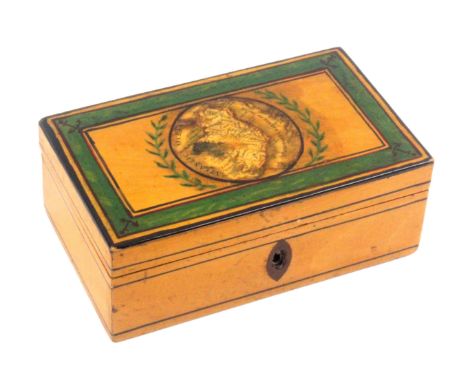
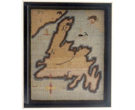
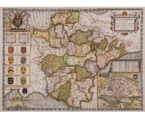
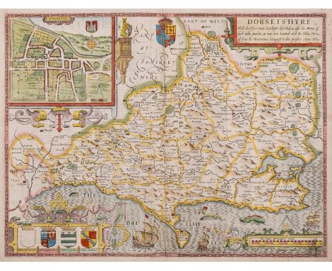
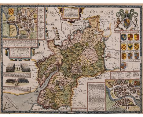
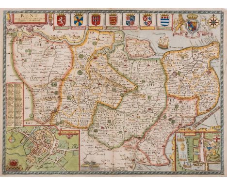
London.The Post Office Plan of London.James Wyld, 1872, hand-coloured folding map in 27 sections, mounted on linen, 432mm x 852mm, original cloth cover with label;London, Environs of London.James Wyld, no date, circular hand-coloured folding map in 24 sections, mounted on linen, 685mm x 620mm, original slipcase with label;Schmollinger (W.) engr., Improved map of London for 1833, from Actual Survey.Engraved map on sheet 453mm x 660mm (repaired tear, lower side margins cropped to edge of border). (3)
We found 109182 price guide item(s) matching your search
There are 109182 lots that match your search criteria. Subscribe now to get instant access to the full price guide service.
Click here to subscribe- List
- Grid
-
109182 item(s)/page
Sicily, Malta and others.[Schmettau], Descrizione Geografica del Regno di Sicilia, sue Isole ....Giovanni Martinon, 1808, folding engraved map of Sicily with Malta inset, 24 sections mounted on linen, 92.5cm x 125cm, an outstanding map, unfortunately significantly damp stained, some sections beginning to lift from tired linen;Sanson, Le Royaume de France ...H. Jaillot, 1692, folding engraved map, hand-coloured in outline, 12 sections mounted on linen, 584mm x 892mm, wear to section edges;Faden [William], Spain and Portugal divided into the respective Kingdoms and Provinces.W. Faden, June 4th, 1796, folding engraved map, hand-coloured in outline, 18 sections mounted on linen, 522mm x 760mm, worn slipcase;Faden [William], Western Hemisphere.W. Faden, May 1st. 1802, hand-coloured circular map, 12 sections mounted on linen, 600mm x 595mm, small stain to Polynesia, faint pencil inscriptions to Atlantic tracking a 19th century voyage, worn slipcase. (4)
Overseas Maps.Roberts [de Vaugondy], Archipel des Indes Orientales qui comprend les Isles de la Sonde, Moluques et Philippines ..Engraved by Delahaye, 1750, hand-coloured engraved map, plate mark 500mm x 633mm; [Wells (Edward)], A New Map of the East Indies Taken from Mr. de Fer's Map of Asia ...Engraved by Sutton Nicholls, no date [?1701], engraved map, plate mark 367mm x 491mm, margins lightly wormed;with seven other maps, comprising four of Asian regions, two of South American regions and a double Hemisphere World map by Gros (1801) (9)
Greenwood (C. & J.).Atlas of the Counties of England from Actual Surveys made from the Years 1817 to 1833 by C. & J. Greenwood.Greenwood & Co. April 1st 1834, large folio, page size 65cm x 80.5cm, title page with hand-coloured general map, forty-six hand-coloured county maps of England and Wales, engraved by J. & C. Walker, later half morocco binding (cloth faded).
2 x German States Commemorative Issue, comprising: (1) Frankfurt, Silver 2 Thaler (3½ Gulden) 1841 (41mm, 37.04g), obv. FREIE STADT FRANKFURT above landscape of the Main with river traffic, the city and the Alte Brücke in the background, rev. denomination and date within wreath, (KM 326), possibly lightly cleaned, otherwise hairlines and contact marks, GVF; and (2) 'Great Fire of Hamburg 1842' AE Medal (44mm, 42.31g), obv. WIRD SICH GLAZENDER WIEDER ERHEBEN ('will rise even more brilliantly'), over Phoenix above a flame, rev. legend around aerial map of Hamburg, hairlines, otherwise EF
* Escape & Evasion. A WWII RAF button compass, together with a saw blade, a paper "goolie" chit printed in French, German, Dutch, Italian, Danish and Serbo-Croat, 33 x 41 cm plus a later silk map of Germany dated 1953, contained in a plastic wallet, together with an Auxiliary Air Force cloth chart of Borneo dated 1944, four WWII paper charts of Tunisia and Northern Europe, a caltrop plus a WWII period brass air recognition model aircraft, 24 cm wingspan x 15.5 cm nose to tailQTY: (11)
* World War II Posters. A collection of WWII posters including 'Careless Talk Costs Lives', circa 1941, 13 colour lithographs promoting the importance of not sharing information, printed for H.M Stationery Office, titles include: Keep mum - she's not so dumb!, Keep it under your hat!, along with 'He's in the Silent Service - are you?', 'Danger Enemy ears are listening', '"Spot at Sight" Chart No 1 & 2 Enemy Uniforms', sizes from 38 x 25.2 cm (15 x 10 ins) to 76 x 50.4 cm (29 7/8 x 19 7/8 ins), together with two maps: North-West Germany, 2nd edition, The British Army of the Rhine and a map of Paris produced by The War Office, 1942, first editionQTY: (1 folder)
An early Tunbridge ware white wood, print and paint decorated box, of rectangular form, line painted sides with oval inlaid escutcheon, the lid with a circular printed map of Ireland, within laurel painted border and outer painted border incorporating anchor spandrils, probably re-painted, the compartmentalised interior in original pink paper, 12.5 x 7.5 x 4.7cms. From the collection of Dr. Brian Austen
Three early Tunbridge ware white wood and card, print and paint decorated pin cushions, comprising a capstan form example in simulated burnt tortoiseshell with circular colour print titled 'Chain Pier Brighton', 6.5cms dia, a pin wheel one side with colour print of Brighton Pavilion indistinctly titled and to the obverse 'Brighton Pier', 5cms dia., and a circular card pin cushion one side with colour print map showing the coast and inland from Sandwich to Reculver, the obverse a colour print of a church perched on the cliff edge (possibly Reculver Church), binding probably an old replacement, 5.2cms dia. (3) From the collection of Dr. Brian Austen
A set of four 18th Century hand coloured mezzotint engravings emblematic of the seasons, each depicting a fashionably dressed young woman with seasonal attributes, comprising Spring, Summer, Autumn and Winter, each inscribed R. Pyle Pinx.t/Chas Corbutt Fecit/London, Printed for and Sold by Robt. T. Sayer, Map and Printseller, at the Golden Buck, near Serjeants Inn, Fleet Street', each 35 x 26cms, in glazed Hogarth style frames, some worm holes and ageing, Winter with some loss to title. (4) A Connoisseur's Collection
Stanhopes, eleven gold or gold coloured charms with Stanhopes comprising a camera, Washington D.C. (4.V) / a key, Paris (12.V) / Peter Pan statue, G.B. map in circle / a book, image damaged / Statue of Liberty, stamped 'AC 14K', New York (4.V) / heart shaped pendant, Hail Mary / Church building stamped 9.375, Lord's Prayer / Nelson with over sized telescope, image lacking / church building, The Lord's Prayer / Cable Car, stamped 14K, Golden Gate Bridge / United State Capitol, stamped AC, Washington D.C. (5.V), last largest 2cms. (11) From the collection of the late Douglas JullÊ
A quantity of French commemorative medals with civic themes, including: Ville d'Arcachon, silver, 59 mm, female figure with town arms, rev. map and speedboat within a border of sea creatures, by R.B.Baron, nearly extremely fine; Ville Saint Denis, a bronze award medal, 72 mm, arms and historical allusions, rev. mother and child with quote after Paul Eluard, ex. presentation inscription (M. Raymond Deliquet 17.12.1976), extremely fine; Ville de Rouen, silvered-bronze plaque, 69 x 50 mm, by Hippolyte Lefèbvre, very fine; Alliance Française, bronze, 68 mm, children of various nations learn French beneath a tree, a ship beyond, rev. inscription (A. J.M. REY FONDATEUR DE "GALLIA" READING 1896), good very fine; and six other similar bronze medals. [10]
A FRAMED AND GLAZED LONDON TRANSPORT BUS MAP, from the 1980's, with a framed and glazed Red Star Eurail Express Parcels map dating from 1987 (map by John Bartholomew), both appear complete and in fairly good condition but the bus map has evidence of folds, creasing and other minor wear, both have evidence of being stuck on boards, size of bus map approx. 107cm wide x 93cm high, Red Star map approx. 108cm high x 84cm wide (2)
TWO FRAMED AND GLAZED 1980'S BRITISH RAIL POSTERS, with two smaller framed and glazed BR 'Coming Soon' posters and a framed and glazed Torbay & Dartmouth Steam Railway sketch Route Map, all appear complete and in fairly good condition but have evidence of folds, creasing and other minor wear and have been stuck to boards, size of largest approx. 107cm high x 69cm wide (5)
A TRAY OF LOOSE AND BOXED LEGO ITEMS, to include a 4100 designer set (boxed), a Lego system road map board with metal finishes to the corners, worn to the edges, a Lego system base piece 799 in grey along with three others inside original sleeve and a selection of loose Lego pieces and figures to unknown models, some torn instructions in boxes, some pieces have been partially constructed
An early 17th century King James Bible, THE HOLY BIBLE, CONTAINING THE OLD TESTAMENT, AND THE NEW: Newly Translated out of the Original Tongues: And with the former Translations diligently compared and revised, By his Majesties Speciall commandment, later full leather (inscribed to FFEP "This book was rebound 1877"), each with woodcut title page, the Old Testament Bonham Norton and John Bill, London 1619, the New Testament Robert Barker and John Bill, London 1620, bound with THE BOOKE OF COMMON PRAYER, with the Psalter or Psalmes of David, Of that Translation which is appointed to be used in Churches, woodcut title page in red and black, Robert Barker, London 1615, and THE GENEALOGIES RECORDED IN THE SACRED SCRIPTURES, according to every familie and tribe [...], By J.S. [presumed to be John Speed] including double page map (at fault) Psalms 83:18: And they that know that thou (whose name is Jehovah) art only the most highest over al [sic] the earth. Dimensions: 17cm W x 8.5cm D x 22cm H
An early 20th oak map chest, the rectangular moulded top above fifteen drawers applied with angular brass swing handles and brass card holders, raised upon a plinth base, 94cm H x 87cm W x 52cm D (drawers tight/stuck, at fault) CONDITION REPORT:Internal drawer dimensions: 75cm W x 45.5cm D x 3.8cm H, apart from 7th drawer down which is 2.5cm H to allow for a structural stretcher. Each drawer appears to have an internal divider approximately 13cm from left hand edge, but some drawers are still stuck closed (several have unseized since the piece has been with us). Some drawer fronts show splits to the edges. The top shows an open joint and staining. The piece is somewhat sunned.
Slavery.- Buxton (Thomas Fowell) The African Slave Trade and its Remedy, signed presentation inscription from the author to front endpaper verso, folding map, original cloth, spine toned, soiling, 8vo, John Murray, 1840.⁂ Buxton was a key figure in the campaign for the emancipation of slavery, and this was his most important publication.
NO RESERVE Forster (E.M.) Alexandria: A History and a Guide, second edition, folding map, illustrations, contemporary ink ownership signature to front free endpaper, endpapers lightly spotted, very occasional finger-soiling marks, original printed boards, lightly rubbed, spine toned, Alexandria, 1938; England's Pleasant land, first edition, original cloth, lightly faded, The Hogarth Press, 1940; Virginia Woolf, light spotting, original wrappers, lightly spotted, spine chipped and discoloured, Cambridge, 1942 § Kirkpatrick (B.J.) A Bibliography of E. M. Forster, original boards, dust-jacket, small abrasion mark to upper panel, some repaired tears, spine lightly toned, 1968; and 8 others, by or about Forster, 8vo (12)
Africa.- Park (Mungo) Travels in the Interior Districts of Africa...in the Years 1795, 1796, and 1797, 2 parts in 1 vol., including Appendix, first edition, stipple-engraved portrait frontispiece, 3 engraved maps / charts (one with routes supplied in red and blue), 5 engraved plates (2 botanical), postscript f., 2 ff. of music, larger map with tear running from inner margin, light offsetting but a clean copy generally, subscriber's copy with armorial bookplate of Robert Eden to front pastedown, W. Bulmer & Co. for the author, 1799; The Journal of a Mission to the Interior of Africa, first edition, folding map, illustrations, light offsetting, for John Murray, 1815, lacking half-titles, uniform contemporary speckled calf, gilt, spines rubbed, spine labels chipped, 4to (2)
NO RESERVE Alps.- Daudet (Alphonse) Tartarin sur les Alpes, illustrations, upper hinge cracked and strengthened with tape, later half morocco, rubbed at joints and corners, partly unopened, Paris, 1885 § Lenthéric (Charles) L'Homme devant Les Alpes, 6 folding maps or plans, occasional light spotting, modern calf, Paris, 1896 § Schmithals (Hans) Die Alpen, colour plates, photographic illustrations, folding map, original upper cover bound in, modern half black morocco, Berlin, 1926, bookplate of Michael Matantos, all but last with original wrappers bound in (lightly rubbed and dust-soiled), the first with ink stamp to lower wrapper, gilt, t.e.g.; and another on the Alps, v.s. (4)
British Women travellers in North America .- Wortley (Lady Emmeline Stuart) Travels in the United States, etc. during 1849 and 1850, 3 vol., first edition, half-title to vol.2 (as called for), ink ownership inscriptions to titles, some spotting and light staining, original blue cloth, spines gilt, corners little worn and bumped, cocked, rubbed, Richard Bentley, 1851 § Murray (Hon. Amelia Matilda) Letters from the United States, Cuba and Canada, 2 vol. in 1, half-titles, folding map, pencil annotations, school prize inscription to front pastedown, occasional spotting, original cloth, spine richly gilt, corners worn, rubbed, John W. Parker and Son, 1856; and 8 others, similar, v.s. (12)
NO RESERVE Britain.- Mogg (Edward) Mogg's New Map of England and Wales, with part of Scotland, calligraphic title in the upper right, engraving with full hand-colouring delineating counties, 1355 x 1060 mm (53 1/4 x 41 3/4 in), dissected and mounted on linen, some scattered spotting and browning, folding with blue paper endpapers, some losses, marbled slipcase with publisher's printed label to upper cover, very worn, 8vo, 1837.
Buckinghamshire.- Speed (John) Buckingham Both Shyre and Shire Towne describ., county map with inset plans of Buckingham and Reading, engraving with hand-colouring, on laid paper with text based watermark, sheet 420 x 540 mm (16 1/2 x 21 1/4 in), central vertical fold with small loss to lower centre, associated handling creases, minor surface dirt, unframed, Bassett & Chiswell, [c. 1676]
Oxford.- Speed (John) Oxfordshire described with ye Citie and the Armes of the Colledges of yt famous University, county map, with inset town plan of Oxford, the vertical margins decorated with the heraldic shields of 18 of the Oxford colleges, engraving with hand-colouring, sheet 415 x 545 mm (16 1/4 x 21 1/2 in) , central vertical fold with some splitting expertly repaired verso, some browning and surface dirt, nicks and tears to extremities with handling creases, a few small marginal losses restored, unframed, Sudbury and Humble, [circa 1611-1627].
Speed (John) Cornwall, county map with inset view of Launceston, vignettes with stone monuments, armorial cartouche, ships and sea monsters, with coats-of-arms below, engraved map by Jodocus Hondius with hand-colouring, 410 x 535 mm (16 1/4 x 21 in), English text verso with thin paper support, central vertical fold with some repairs to splitting, repaired tear running through title and view of Launceston, small marginal loss to the lower right and lower centre, Bassett & Chiswell, [circa 1676].
Devon.- Speed (John) Devonshire with Excester Described, county map with inset view of Exeter, engraving with early hand-colouring, platemark 385 x 520 mm (15 1/8 x 20 1/2 in), sheet 400 x 545 mm (15 3/4 x 21 1/2 in), central vertical fold with some expert repairs, a few small splits and losses restored within green pigments, some spotting and browning, unframed, [c. 1676].
Dorset.- Speed (John) Dorsetshyre, county map with inset plan of Dorchester, engraving with hand-colouring, platemark 383 x 510 mm (15 1/8 x 20 in), sheet 420 x 540 mm (16 1/2 x 21 1/4 in), marginal nicks and repairs, some minor surface dirt, some restoration to central vertical fold, unframed, Bassett & Chiswell, [1676]
Gloucestershire.- Speed (John) Glocestershire contrived into thirty thre several hundreds, first edition, county map with inset plan of Bristol and Gloucester, engraving with early hand-colouring, sheet 430 x 520 mm (16 7/8 x 20 1/2 in), central vertical fold reinforced verso, small repaired tear to lower margin, marginal surface dirt, unframed, Sudbury and Humble, [1611].
London.- Chancellor (E. Beresford) The History and Antiquities of Richmond, Kew, Petersham, Ham, limited edition signed by the author, original cloth, gilt, spine ends frayed and rubbed, 1894 § Kingsford (C.L.) Drawings of Buildings in the Area Described in the Early History of Piccadilly, Leicester Square, and Soho, plates, some lightly soiled to margins, modern morocco-backed boards, spine rubbed, 1926; and 3 others including a geological map of London, 4to & 8vo (5)
London.- Homann (Johann Baptist) Regionis, quae est circa Londinum, specialis repræsentatio geographica, map of the environs of London, from Maidenhead to Bishop's Stortford, and Chelmsford to Leatherhead, with panoramic view of the River Thames below, engraving with some early hand-colouring on laid paper with watermark of a fleur-de-lis, platemark 510 x 580 mm (20 x 22 3/4 in), sheet 525 x 580 mm (20 3/4 x 22 3/4 in), central vertical fold as issued, minor nicks and tears, reinforced verso, light handling creases, marginal surface dirt, unframed, 1741.
London.- Tallis (John) Tallis's Illustrated Plan of London and its Environs in commemoration of the Great Exhibition of Industry of all Nations, with paneled border containing 49 views of buildings and monuments, the map showing from Highgate Cemetery to Brixton, and from Shepherd's Bush to Greenwich Marshes, engraved map with fine hand-colouring, 555 x 730 mm (21 3/4 x 28 3/4 in), under glass, old folds, a few minor handling creases and small nicks, framed, 1851.
NO RESERVE Norfolk.- Bryant (Andrew) Map of the County of Norfolk, with vignette view of Norwich Cathedral lower right, and key to map in the lower left corner, large engraved folding map with vibrant original hand-colouring, in two sections, "North" and "South", each approx. 725 x 2270 mm (28 1/2 x 89 1/2 in), dissected and mounted on linen, decorated with green silk edges, folding with very worn green endpapers, off-setting, browning, spotting and and surface dirt, heavy spotting to far right strip, some sections lifting up from linen, 4to, published by Bryant, 1826.
NO RESERVE Norfolk.- Milne (Thomas) A Topographical Map of the County of Norfolk, Reduced... from the Large Map in Six Sheets, engraved county map with outline hand-colouring, 605 X 895 mm (23 3/4 x 35 1/4 in), dissected and mounted on linen, some spotting and surface dirt, minor offsetting, folding into marbled slipcase with owners printed label to upper cover 'Frederic Lane, Lynn', spines splitting and very worn, 8vo, William Faden, 1803; together with 2 parts only (of 3; lacking western section with calligraphic title) of Greenwood's large scale map of Somerset, with fine vibrant hand-colouring, in book-style slipcase, and a two-sheet Ordnance Survey map of Lincoln and Hull, published by J. Wyld, folding into slipcase, 8vo, 19th century (3)
NO RESERVE Scotland.- Armstrong (Marcus) A New Map of Scotland or North Britain, wherein all the Post and other Public Roads are Correctly Delineated, large detailed map, engraving with outline hand-colouring, on four sheets joined as two horizontal sections, each section approx. 670 x 1090 mm (26 1/4 x 42 7/8 in), central and vertical folds with some repaired splitting, handling creases, surface dirt and browning, unframed, 1782.
NO RESERVE Scotland.- Zatta (Antonio) Il Regno di Scozia, Di Nuova Projezione, engraved map with hand-colouring, platemark 315 x 410 mm (12 1/4 x 16 1/8 in), sheet 385 x 495 mm (15 1/4 x 19 1/2 in), central vertical fold, minor surface dirt, handling creases, unframed, Venice, 1776; together with 5 further maps of Scotland, including a good impression of Blaeu's 'Scotia Regnum', a fully hand-coloured engraving of 'Views of the principal Towns and Castles in Scotland for Mr Tindal's Continuation of Mr Rapin's History', maps by Thomas Kitchin, Robert Morden, and Thomas Bowen, engravings with hand-colouring, various sizes between approx. 330 x 230 mm (13 x 9 in) and 400 x 500 mm (15 3/4 x 19 3/4 in), all unframed, 17th and 18th century (6)
Somerset.- Speed (John) Somerset-Shire Described and into Hundreds divided with the plot of the famous and most wholsom waters and citie of the Bathe, First edition, county map with inset plan of Bath, engraving with hand-colouring, on laid paper with armorial watermark, platemark 383 x 512 mm (15 1/8 x 20 1/4 in), sheet 407 x 540 mm (16 x 21 1/4 in), central vertical fold with splitting repaired verso, small loss restored to foot, small carefully repaired tears, marginal nicks and tears, notably the upper left corner, minor surface dirt, unframed, Sudbury and Humble, [1611].
NO RESERVE Yorkshire.- Greenwood (Christopher) Map of the County of York, made on the Basis of Triangles in the County, determined by Lieut. Col. Wm. Mudge, county map in six sections, with calligraphic title, compass rose, and a table of explanation, engraved map with hand-colouring, each sheet approx. 610 x 1085 mm (24 x 42 3/4 in), dissected and mounted on linen, some offsetting, scattered spotting and browning, surface dirt, folding into slipcase, very worn, 8vo, J. & C. Greenwood, 1817; together with another uncoloured copy of the same map, on nine sheets, with index sheet, heavy browning and surface dirt, presented in book-style slipcase, worn, 1817 (2)
NO RESERVE Yorkshire.- Teesdale (Henry) To the Nobility, Gentry & Clergy of Yorkshire, this map of the county constructed from a survey commenced in the year 1817 & corrected in the years 1827 & 1828 is respectfully dedicated by the proprietors, large scale county map in 3 sections, engravings with original hand-colouring, each section approx. 1830 x 735 mm (72 x 29 1/2 in), each section dissected and mounted on linen and edged with green linen, some missing, several splits and tears to folds crudely repaired verso, scattered spotting and browning, some off-setting, surface dirt, folding with marbled end, very worn, 4to, 1828.
Chubb (Charles) The Birds of British Guiana, based on the Collection of Frederick Vavasour McConnell, 2 vol., first edition, one of only 250 copies, portrait, 20 coloured plates after H. Gronvold, 24 photographic plates, folding map, numerous illustrations in text, contemporary ink gift inscriptions to endpapers, map with closed tear at inner margin, not affecting image, vol. 1 upper hinge cracked, contemporary dark blue calf, "J. V. McConnell" lettered in gilt on upper covers, spines gilt with red morocco labels, vol. 1 with spine sunned and covers a little faded, lightly rubbed, inner gilt dentelles, t.e.g., others uncut, [Nissen, IVB 198], large 8vo, 1916-21.
-
109182 item(s)/page