We found 109198 price guide item(s) matching your search
There are 109198 lots that match your search criteria. Subscribe now to get instant access to the full price guide service.
Click here to subscribe- List
- Grid
-
109198 item(s)/page


![Jan Jansson: 'Cantium Vernacule Kent [Kent]', engraved hand coloured map, circa 1646, latin text verson, approx 38.5 x 49.5cm](https://cdn.globalauctionplatform.com/db92bc8e-909d-46a5-84b8-ad320108d7a6/0412ffe8-120d-4afa-90b4-ad36011762ee/468x382.jpg)
![Johannes Blaeu: 'Huntingdonensis Comitatus [Huntingdonshire]', engraved hand coloured map, circa 1645, decorative title carto](https://cdn.globalauctionplatform.com/db92bc8e-909d-46a5-84b8-ad320108d7a6/6976ef9b-60ff-4a47-b8f1-ad360117663c/468x382.jpg)
![Johannes Blaeu: 'Northantonensis Vernacule [Northamptonshire]', engraved hand coloured map, Amsterdam, circa 1650, approx 41.](https://cdn.globalauctionplatform.com/db92bc8e-909d-46a5-84b8-ad320108d7a6/2f1b5dab-6fec-4842-8e29-ad360117694f/468x382.jpg)
![Johannes Blaeu: 'Comitatus Nottinghamiensis [Nottinghamshire]', engraved hand coloured map, circa 1648, together with an unco](https://cdn.globalauctionplatform.com/db92bc8e-909d-46a5-84b8-ad320108d7a6/291dd050-7c6d-43c0-b850-ad3201119209/468x382.jpg)
![Johannes Blaeu: 'Comitatus Northumbria [Northumberland]', hand coloured engraved map, circa 1645, latin text verso, approx 40](https://cdn.globalauctionplatform.com/db92bc8e-909d-46a5-84b8-ad320108d7a6/7ad599f4-228a-406e-9596-ad3601176c59/468x382.jpg)
![John Speed: 'The Countye Palatine of Chester [Cheshire]', 18th Century engraved hand coloured map, without text verso, inset](https://cdn.globalauctionplatform.com/db92bc8e-909d-46a5-84b8-ad320108d7a6/9af8fed3-bbef-4622-9f34-ad3601176fe0/468x382.jpg)
![Johannes Blaeu: 'Cestria Comitatus Palatinus [Cheshire]', engraved hand coloured map, circa 1645, approx 38.5 x 50.5cm, frame](https://cdn.globalauctionplatform.com/db92bc8e-909d-46a5-84b8-ad320108d7a6/6597b3fe-74bb-41ef-8cae-ad360117738b/468x382.jpg)

![Johannes Blaeu: 'Devonia vulgo Devon-Shire [Devon]', engraved hand coloured map, circa 1645, French text verso, approx 39.5 x](https://cdn.globalauctionplatform.com/db92bc8e-909d-46a5-84b8-ad320108d7a6/d7665846-28ea-4487-8149-ad3601177a59/468x382.jpg)

Lot 7029
John Speed: 'Cornwall', engraved hand coloured map, circa 1611, Sudbury & Humble, inset view of Launceston, ships, sea monsters and heraldic shields, some wear along central fold with tape reinforcement verso, framed and double glazed, English text verso, approx 38 x 50.5cm, the whole approx 51 x 64cm
![Johannes Blaeu: 'Anglia Regnum [England & Wales]', engraved hand coloured map, Amsterdam, circa 1662, decorated with four](https://cdn.globalauctionplatform.com/db92bc8e-909d-46a5-84b8-ad320108d7a6/9d039bf8-5b51-47ca-a55a-ad3601178120/468x382.jpg)
Lot 7030
Johannes Blaeu: 'Anglia Regnum [England & Wales]', engraved hand coloured map, Amsterdam, circa 1662, decorated with four ships, a scale of miles flanked by sheep and a cherub, and two coats of arms of Great Britain and England surmounting the title cartouche, Spanish text verso, framed and double glazed, approx 38.5 x 50cm, whole approx 56 x 68cm

Lot 7032
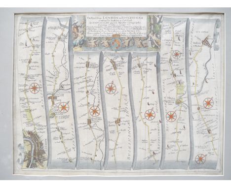
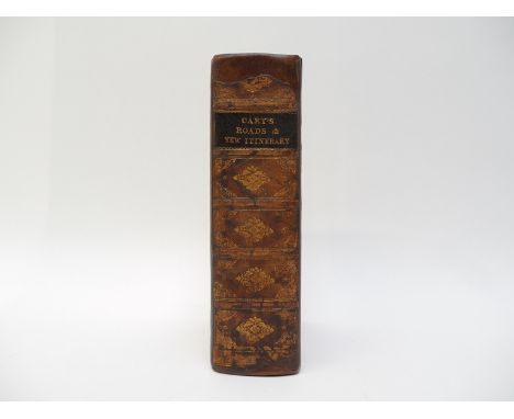
Atlases, England & Wales - John Cary: 'Cary's Travellers's Companion; or, a Delineation of the Turnpike Roads of England and Wales; shewing the immediate Route to every Market and Borough Town throughout the Kingdom', London, G & J Cary, 1826, copper plate engraved title page + 43 engraved maps, all with hand colouring in outline, including folding map of Yorkshire, as called for, bound together with 'Cary's New Itinerary: or, an accurate delineation of the great roads, both direct and cross, throughout England and Wales', 1826, 10th edition, hand coloured large folding map of England & Wales + 6 engraved folding maps, hand coloured in outline, as called for, contemporary calf gilt, rebacked retaining original backstrip, contemporary ownership signature of Viscount Galway, Serlby, Notts., verso FFEP, with some manuscript notes on distances of a journey on page preceding title

Lot 7033
Lengths and Levels to Bradshaw's Maps of the Canals, Navigable Rivers and Railways, in the Principal Parts of England, dedicated to Thomas Telford, 1833, 8vo, pp15 + [1], [bound with] Canals and Navigable Rivers, no separate title, pp5-20, [bound with] lengths and levels to Bradshaw's Maps of Canals, Navigable Rivers from actual survey, dedicated to Thomas Telford, 1832, pp15 + [1], folding engraved map to third part; 'Continuation of the Lea Navigation and River Stort' + 'Continuation of the Grand Junction Canal and the proposed London & Birmingham Rail Way', publisher's paper-covered boards

Lot 7035
19th Century topography, engraved plate books - Baines & Fairbarn: 'Lancashire & Cheshire Past & Present' circa 1867, two volumes in four divisions, two added engraved Vignette titles, seven portraits, 13 views and five maps / plates, original decorative cloth gilt, all edges gilt, Elmes & Shepherd: 'Metropolitan Improvements, Or London in the Nineteenth Century: Being a series of views', 1827 - 1829, added engraved title and 160 engraved views on 80 plates, old cloth gilt, John Duthy: 'Sketches of Hampshire', Winchester, Jacob & Johnson, [1838], 1st edition, engraved map and eight plates (of which two coloured) as called for, old cloth gilt, (rebacked) (6)
Lot 7036
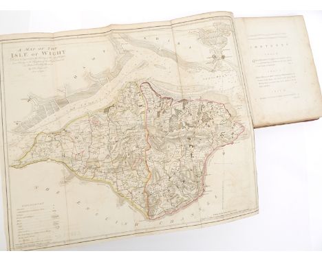
Richard Worsley: 'The History of the Isle of Wight', London, R. Dodsley et al, 1781, 1st edition, engraved vignette title page + 31 engraved maps/plans/plates, comprising large folding hand coloured map of the Isle of Wight, double page plan of Carisbrook Castle plus 11 further double page engraved views, 18 engraved plates, plus 6 engraved vignettes, large 4to, contemporary marbled paper covered boards, professionally later calf rebacked and recornered, two bookplates of John Hewlett Alden loosely inserted
Lot 7039
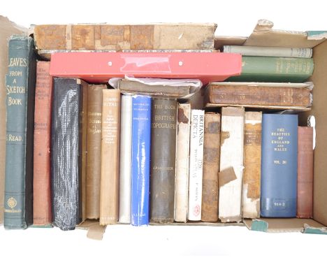
A collection of 20 assorted topographical interest volumes, including Samuel Read: 'Leaves from a Sketch-Book', 1875, plates, original cloth gilt; Fuller: 'The History of the Worthies of England', 1811, vol 2, contemporary calf very worn; Coles Finch: 'Watermills & Windmills', 1976, in dust wrapper; Shoberl: 'The Beauties of England & Wales', 1813, vol 14, engraved map of Suffolk, engraved plan of Ipswich, numerous engraved plates of Suffolk, engraved plan of Chichester, numerous engraved plates of Surrey and Sussex, ex library, rebound lib. cloth gilt; 'A Guide to the Architectural Antiquities in the Neighbourhood of Oxford', 1842, engraved plans & plates, old half calf gilt very worn; Boutell: 'The Monumental Brasses of England', 1849, etc

Lot 7041
Norfolk section, pp.123-156, from Fuller's 'The Worthies of England', 1811 edition, together with Norfolk section pp.89-113 from 'England Illustrated', [1764], with engraved map by Thomas Kitchin and engraved illustrations of Norwich Castle, S.E. view of Norwich, and Wymondham Abbey, from the library of the late Ron Fiske of Morningthorpe Manor, esteemed local historian, bibliophile and collector, each volume large 4to, handsomely and uniformly rebound for Ron Fiske in half tan leather, morocco gilt spine labels, each with his bookplate to front pastedown (2)
Lot 7043
Francis Blomefield: 'An Essay Towards a Topographical History of the County of Norfolk', London, William Miller, 1805-1810, 11 volumes, mezzotint portrait frontis plus 3 folding engraved maps/plans (comprising Norwich, King's Lynn & Map of Marshland (often not present)), plus 33 engraved plates (many folding) plus 14 pedigrees on 15 folding sheets as called for, half titles, ex Exeter City Library, uniform rebound green library cloth gilt, some library markings and some single page plates toned as usual, but else internally an extremely clean and tidy set, with all folding maps, plates and pedigrees professionally backed onto linen to reinforce and conserve them, inner joints professionally reinforced, a good, presentable utilitarian set of Blomefield's comprehensive history of the county of Norfolk, widely considered to be detailed, reliable and comparable with the best county histories of the period (11)


Lot 557
A World War II US combined emergency compass and waterproof match holder, by Foster Grant, height 7.5cm, together with a Sestral handheld boat or yacht compass, height 14cm, a Bavarian combined compass and sporting glass, boxed, a map measure, in leather case, and a reproduction cased compass (5).Condition report: All pieces are working and complete, some minor surface rust


Lot 510
Ephemera. Le Petit Journal, four issues dated 1909., Map of The Environs of Montpellier., fashion journals for 1914 and 1938, sheet music, a copy of The Daily Mail for Queen Victoria's Golden Jubilee June 23rd 1897., The Coventry and Warwickshire Graphic October 23rd 1914, together with various pictures. (a quantity)


Lot 51
*Robin Furness (b.1933)The Warwickshire, The Kill on Harrow Hill, Long Comptonlimited edition colour print, signed in pencilimage 36 x 49.5cm, andThe Hampton Hunt Series map of Foxhound Hunts of Great Britaincolour print66 x 48cm (2)*Artist's Resale Right may apply to this lot.Condition report: Both with very strong colours and in good condition.
Lot 5332
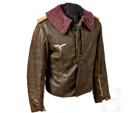
A Leather Jacket for Fighter Pilots Brown leather jacket with bluish-purple fur collar. Front covered fly with blue plastic buttons (two brown replacements), horizontal map pocket on left breast. White plastic Ri-Ri zip closures on sleeves with button, flap sleeve secure strap and blue cotton inner sleeve. Glove cuff connections removed. Blue-grey rayon liner with olive coloured cloth drawstring ties. Machine-embroidered white breast eagle on blue-grey backing is hand applied. Oberleutnant slip-on shoulder boards, attached through shoulder bridles and sewn down at the button. Wear and fading to the jacket around arms, elbows and back.USA-Los: Versand aus den USA.Zustand: II - IIIA leather jacket for fighter pilots Brown leather jacket with bluish-purple fur collar. Front covered fly with blue plastic buttons (two brown replacements), horizontal map pocket on left breast. White plastic Ri-Ri zip closures on sleeves with button, flap sleeve secure strap and blue cotton inner sleeve. Glove cuff connections removed. Blue-grey rayon liner with olive coloured cloth drawstring ties. Machine-embroidered white breast eagle on blue-grey backing is hand applied. Oberleutnant slip-on shoulder boards, attached through shoulder bridles and sewn down at the button. Wear and fading to the jacket around arms, elbows and back.USA-Lot: Shipping from the USA.Condition: II - III
Lot 5698
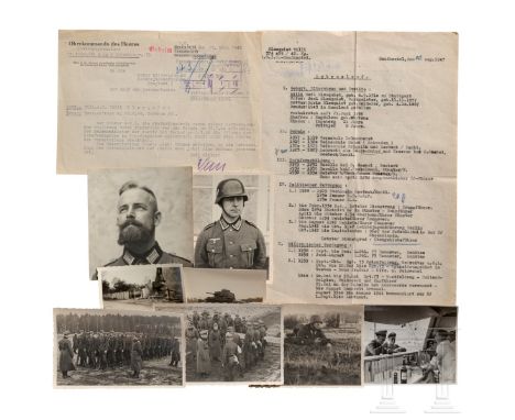
HJ-Obergebietsführer Willi Blomquist – ca. 130 Fotos als Offizier der Wehrmacht, sein Lebenslauf sowie sechs Briefe/DokumenteAus seiner bewegten Zeit als Offizier der Wehrmacht. Ca. 130 Fotos seiner Militärzeit 1938 - 1945, dabei Fotos in unterschiedlichen Formaten, Portraitfotos in Uniform, Ausbildung, Besprechungen, Schießübungen, Essen fassen, Fotos seiner Arm-OP (!), im Sanatorium, Polen- und Westfeldzug, auch Russland. Fünf Briefe an und von ihm mit Umschlägen, 1937-43, privat und Feldpost. Eine Straßenkarte, 1942, von Südost-Europa, eine Ausgabe der Deutschen Zeitung in den Niederlanden, 1942, auf dem Titelblatt mit einem großen Bericht und Foto über die Amtseinführung von Blomquist durch Hauptdienstleiter Schmidt. Ein geheimes Schreiben des OKH vom 17.03.45, Heerespersonalamt: "... der Führer (!) hat Oblt. Blomquist die Freiheitsstrafe (!) wegen seiner hervorragenden Tapferkeit vor dem Feinde am 25.09.44 erlassen". Dazu der mit Schreibmaschine gefertigte Lebenslauf von Willi Blomquist von Geburt an bis zur Zeit nach der Kapitulation 1945, datiert auf den 20.04.47, Lager Sandbostel, mit seiner Unterschrift. Insgesamt guter Zustand mit Altersspuren.Zustand: IIHJ-Obergebietsführer Willi Blomquist – approx. 130 photographs as officer in the Wehrmacht, his CV and six letters/documents From his eventful time as Wehrmacht officer. Approx. 130 photographs from his military time 1938 – 1945, including pictures in various formats, portrait photographs in uniform, training, discussions, shooting practice, food distribution, photographs of his arm operation (!), in the sanatorium, military campaigns in Poland and in the west, also Russia. Five letters to and by him with envelopes, 1937-43, private and field post. A road map, 1942, of southeastern Europe, a copy of the Deutsche Zeitung (German newspaper) in the Netherlands, 1942, on the front page a large report and photograph documenting the inauguration of Blomquist by Hauptdienstleiter Schmidt. A secret letter of the High Command of the Army dated 17 March 1945, Army Personnel Office: (tr.) “… on 25 September 1944, the Führer (!) waived the prison sentence (!) imposed on Oblt. Blomquist due to his excellent bravery in the face of the enemy”. Comes with the typewritten CV of Willi Blomquist starting with his birth until the surrender in 1945, dated 20 April 1947, Sandbostel camp, with his signature. In good overall condition with traces of age.Condition: II


Lot 314
ALLEGORIE "DIE MALEREI". Meissen. Datierung: Vor 1924. Meister/Entwerfer: Modell M.V. Acier. Technik: Porzellan, farbig und gold staffiert. Beschreibung: Drei auf einem Felssockel gruppierte Putten um eine Staffelei versammelt. Vor ihr, mitüberschlagenen Beinen auf einem Schemel sitzend, Putto mit Farbpalette und Pinsel. EinPutto zu seinen Füßen sitzend, ein weiterer mit Zeichenmappe unter dem Arm über dieLeinwand gebeugt, die einen bereits halbfertig gemalten Putto zeigt. Maße: Höhe 19cm. Marke: Schwertermarke, No.5, Bossierernummer 11, Malernummer 44. Der Entwurf für diese Gruppe gehört zu den Modellen der sogenannten 'Großen Russischen Bestellung'. Die insgesamt 40 Kleinplastiken wurden 1772 für Kaiserin Katharina II bei Kaendler in Auftrag gegeben, der alle zeichnerischen Einwürfe lieferte. Für die Ausformung wurde anschließend Michel Victor Acier als Modelleur hinzugezogen. Bestimmt waren die Figuren zur Ausstattung eines Kabinetts, in einem Pavillion im Garten von Schloss Oranienbaum bei St. Petersburg.Die 'Malerei' ist eine von acht Allegorien, die auf Katharinas Rolle als Förderin der Künste und Wissenschaften verweisen. Erläuterungen zum KatalogMeissen Deutschland Porzellan 19./20. Jahrhundert Allegorie Acier, Michel Victor PORCELAIN ALLEGORY "THE ART OF PAINTING". Meissen. Date: Before 1924. Maker/Designer: Model M.V. Acier. Technique: Porcelain, enriched in colours and gold. Description: Three putti on a rock base, gathered around an easel. One putto sitting on a stool infront of it, his legs crossed, holding a colour palette and a brush. One putto sitting at his feet. Another, holding a map with drawings under his arm, is bent over the cnvas, which shows a half finished painting of a putto. Measurement: Height 19cm. Mark: Swordsmark, No.5, porcelain former's no. 11, painter's no. 44. The design for this group is part of the models for the so-called 'Great Russian Order'. The 40 small sculptures were commissioned in 1772 for Empress Catherine II. Kaendler provided all the drawings for the designs. Michel Victor Acier was then consulted as a modeller for the mouldings. The figurines were intended to furnish a cabinet in a pavilion at the garden of Oranienbaum Palace near St. Petersburg.'Painting' is one of eight allegories that refer to Catherine's role as a patron of the arts and sciences. Explanations to the Catalogue

Lot 701
A set of historic county maps and prints, including The Neighbourhood of Windsor, after James Hakewill engrave of c.1813, and showing the surrounding areas including Colnbrook, Staines and Chertsey, framed and glazed (24.5x29.5 cm), together with Berkshire (2) and Bowles's ruduced map of Hampshire c.1782 acording to a pencil inscription verso, different dates and sizes. (4).


-
109198 item(s)/page