We found 109198 price guide item(s) matching your search
There are 109198 lots that match your search criteria. Subscribe now to get instant access to the full price guide service.
Click here to subscribe- List
- Grid
-
109198 item(s)/page


Lot 306
With Fine Lithographic Plates Paris: Charpentier (H.)publ. Paris dans Sa Splendeur Monuments, Vues, Scenes Historiques, Descriptions et Histoire, Vols. II & III, 2 vols. (ex. 3) lg. folio 1861. Full page cold. map, & 51 full page plts. some cold. tinted, orig. mor. backed gilt decor. cloth. As a coll. of plts. (2)

Lot 345
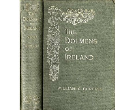
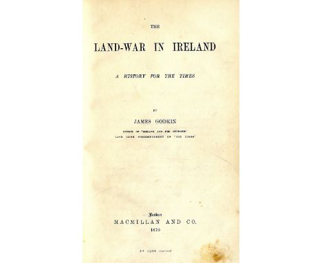
Box: Irish interest: Madden (R.R.) The United Irishmen, Their Lives and Times, 2 vols. L. 1842; Young (R.M.) Ulster in '98, Belfast 1893; Davis (F.) The Belfast Man, Earlier and Later Leaves; or An Autumn Gathering Belfast 1878; [Cusack (M.F.)] An Illustrated History of Ireland; Kenmare 1868, cold. frontis, lg. fold. map, & illus.; Lever (Chas.) The Dodd Family Abroad, L. 1872, plts. hf. mor.; Hall (Mrs. S.C.) Sketches of Irish Character, L. 1855, plts. & illus., hf. calf; Mangan (J.C.) Essays in Prose and Verse, 16mo D. (Duffy) 1906; & over 40 others of varied Irish interest, biography, history etc. As a box, w.a.f. (1)

Lot 348
Box: Leather Bindings, etc: A Collection of Scarce & Interesting Tracts, 4to L. 1795, recent 1/4 calf; Duigenan (P.) An answer to the Address of Rt. Hon. Henry Grattan, D. 1798, uncut, recent cloth; The General Laws of Estates or, Freeholder's Companion, L. 1740, calf; Wilson (R.T.) History of the Expedition to Egypt, L. 1803, calf; Giraud - The Campaign of Paris in 1814, L. 1815. hd. cold. plan frontis & fold. map, calf; & approx. 22 others, mostly leather bound; together with a bundle of pamphlets, mostly Second World War interest. As a coll, w.a.f. (1)


Lot 1123
A 17th century map engraving of Hungary by William Saxton pub. Rome 1688, to/w an engraved city plan of the Hague, datd 1560, an aerial view of Ingoldstat under siege and a 19th century map engraving of Cambridgeshire (4 - mounted, framed and glazed) Condition Report Largest map has some undulations - others good condition


Lot 640
An 18th century black and white aquatint engraving after R Smirke & J Emes showing a meeting of The Society of Royal British Archers in Gwersyllt Park, Denbighshire, dated 1794 and dedicated to His Royal Highness George, Prince of Wales, 50 x 66 cm in burrwood frame with gilt slip together with a late 18th century coloured engraving after Thomas Hearne showing Beverstone Castle, dedicated to Michael Hicks esq, dated 1778, 23 x 28 cm in gilt frame, and an unframed early 18th century map of Gloucestershire, 42 x 49 cm
Lot 617
A collection of pictures and prints relating to topography including an 18th century road map showing the route between Cirencester and Chipping Sodbury, showing the Arms of Bristol, 19 x 12 cm, a map of the Island of Sark, a pair of signed coloured limited edition prints after K W Burton showing The Clifton Suspension Bridge and Bourton on the Water, etc (all framed) together with a collection of unframed photographs relating to Concorde

Lot 599
A collection of pictures and prints including a 19th century Collins' railway and telegraph map of Warwickshire, a needlework panel of oval form showing a bird in oval gilt frame, various unframed prints and engravings including two examples after Bruce Bairnsfather, a boxed oriental bamboo scroll painting, etc


Lot 471
New Plan of The City of London, Westminster and Southwark/Dedicated to the Rt. Hon. Sir George Thorold/coloured engraving, 50cm x 68cm/see illustration Condition Report: This map is in good condition, there are a few small stains on the surface and it has been mounted close to the margins and is glazed and framed.


Lot 338
A Map of the Peiho River from the Gulf of Pechele to Pekin, c.1840, on laid paper, engraved on steel by Louis Becker and published by George Routledge & Co., Faringdon Street, London, several splits, 49.8cm square Various notes include 'the ten ports open to European commerce', 'the last census was 1812' and 'beside the Wenho River, the country perfectly level abounding with trees and richly cultivated'. 清约1840年 中国地图


Lot 212
1938 German Grand Prix rare Mercedes-Benz English press pack, complete as issued with 26 M-B black & white gloss photographic prints on 12 card sheets, a Nurburgring map, German GP history, M-B race results and achievements, driver biographies for Lang, Caracciola, Brauchitsch, Seaman, M-B technical data and race team anecdotes, a quantity of results sheets issued by the race organisers, a notepad with hand written lap charts, plus the official race programme; sold with a 1934 German Grand Prix souvenir programme and result sheets, a 1938 Coppa Acerbo racecard and an Alfa Corse driver results booklet, including Tazio Nuvolari (qty.) Mercedes-Benz finished first and second in this historic race with Richard Seaman becoming the third British driver ever to win a Grande Epreuve, his victory celebrations somewhat tainted by the Nazi salutes given by many of the German contingent. Unfortunately he would lose his life driving for the team the following year after crashing his Mercedes-Benz during the Belgian Grand Prix at Spa.


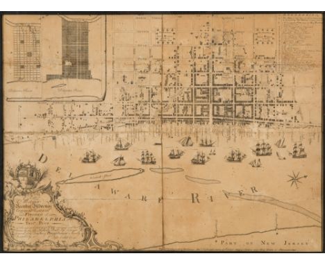
Lot 505
AN EARLY ENGRAVED MAP OF PHILADELPHIA, NICHOLAS SCULL, 1762To the Mayor, Recorder, Aldermen, Common Council and Freemen of Philadelphia this plan of the improved part of the city, surveyed and laid down by the late Nicholas Scull, Esqr., Surveyor General of the Province of Pennsylvania, is humbly inscrib'd by the editors., Philadelphia: Sold by the editors, Matthew Clarkson and Mary Biddle, 1762. Measurements: 48.5 x 66 cm (19 1/8 x 26 cm) [sight]PROVENANCE Collection of Jacob Gamble, Philadelphiathence by descent in the family (according to a handwritten note dated June 8, 1931, affixed to the backing)LITERATUREM.P. Snyder, City of Independence: Views of Philadelphia Before 1800, (1975), pp. 62 ff.S. Bedini, The Scull Dynasty of Pennsylvania Surveyors, in Professional Surveyor Magazine (May 2001)LOT NOTESA very rare map and important historical document in its own right, the last time a similar map was offered at public auction was at Sotheby's auction of Fine Books and Manuscripts on June 11, 2013, with an estimate of $100,000-150,000. As Martin P. Snyder notes about this map in City of Independence, this map was the first detailed map of the interior of Philadelphia. It was the first map to identify all the streets and alleys of Philadelphia, and the exact locations of important institutions of the time. The cataloguing for the Sotheby's lot notes that they located only five copies in public institutions: Philadelphia, Historical Society of Pennsylvania (2 of which one is defective); Philadelphia, Library Company; New York Public Library, Stokes Collection; Washington D.C., Library of Congress. PLEASE NOTEIf you will be bidding live on auction day, please note that Session I of the Auction (Russian Fine & Decorative Art), starts at 10:00 AM New York Time and goes from Lot 1 through Lot 234. Session II of the Auction (European, American and International Fine & Decorative Art) starts at 2:00 PM New York Time and goes from Lot 500 through Lot 657. We sell approximately 70 lots per hour.


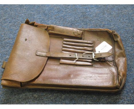


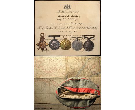
Lot 19
1914 Star Trio (entitled to clasp & rosette), with EDVII Army LSGC Medal, and Defence Medal. Mentioned In Despatches 31st May 1915 Certificate. To 80670 R.S.Mjr C H Flay RFA (served with 1/DAC RFA). (W.O.CL.1. on Pair), and (B.Q.M.Sjt on LSGCM). Together with an original Imperial German Army Cap and a Trench Map for Gouzeacourt 24/10/17. Interesting lot


-
109198 item(s)/page