We found 109182 price guide item(s) matching your search
There are 109182 lots that match your search criteria. Subscribe now to get instant access to the full price guide service.
Click here to subscribe- List
- Grid
-
109182 item(s)/page


Lot 280
Harmsworth Atlas, C. 1910. Folio, qtr binding, gilt. Featuring Antarctic maps with details of Ross, Challenger, Nordenskiold, Scott & Bruce expeditions., pre - revolutionary Russian Empire, Colonial Africa & some UK town/city maps etc. CONDITION REPORT: Binding marked and rubbed but sound. Map contents generall vg.


Lot 307
Taunt H. : A New Map of the River Thames, C. 1885. Fifth Ed. Small 8vo. Original calf binding with gilt titling & illustrations ( professionally re-backed ), aeg. Mounted photo frontis, text with sectional maps h/c in outline together with smaller mounted photos. Many contemporary adverts with engraved illustrations.

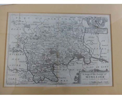
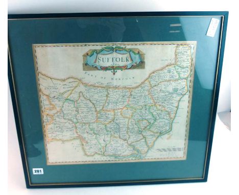
Lot 319
Blome R. : Mapp of the County of Midlesex, Mapp of the County of Surrey and Mapp of the County of Sussex C.1720, possibly from Thomas Taylor's England Exactly Described in 1715. Together with a strip 'Road map from London to the 196 milestone in the way to St. David's measured from Cornhill' - possibly from Universal Magazine, 1766. All mounted, frame and glazed.


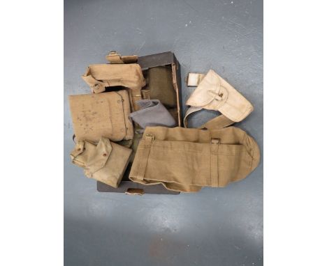
Lot 1461
Two Circa 1930's / 40's Sheffield Empire Theatre Posters, showcasing 'The Nitwits' and 'Peter Cavanagh' etc, each 37 x 24cm, two 1940's German illustrated publications, an electroplated gallery tray, 1913 Sheffield tramways enamel badge, XIX Century book page with strip map of Barnsley etc.

Lot 1480
AFTER MORDEN (Robt); Oxfordshire, a hand coloured and engraved map, framed and glazed, 42 x 37cm; Another, Kitchen (T), Warwickshire, 23 x 18cm. After CARY (John) ; Wiltshire, a hand coloured engraved map, framed and glazed, 53 x 42cm; Another, Blome (Richard), Lincolnshire, 32 x 26.5cm. (4)

Lot 121
'Kent', 17th century map by Robert Morden (British 1650-1703) 35cm x 64cm, five other 18th/19th century maps and collection of 18th/19th century hand coloured engravings depicting Country Estates and Rural Landscapes framed and unframed max 44cm x 31cm (qty) Condition Report Click here for further images, condition, auction times & delivery costs

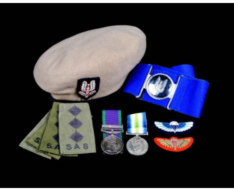
Lot 1009
By order of the recipient: the remarkable and historically significant Operation Mikado/ Plum Duff pair of medals to Captain Andrew Legg, 22nd Special Air Service Regiment and Royal Hampshire Regiment, offered together with his Beret and associated memorabilia: Medals: General Service 1962-2007, clasp: Northern Ireland (LT A LEGG R HAMPS), mounted individually for wearing, uneven toning but otherwise extremely fine; South Atlantic, with three loose rosettes (CAPT A LEGG R HAMPS (SAS)), in original card box stamped 'WITH ROSETTE', extremely fine. [3] Together with: the recipient's beret, with OR's fabric badge as commonly worn by S.A.S. officers; the map which he carried on his mission into South America, showing, in small scale and without grid-lines or significant details, Tierra del Fuego and adjacent areas; his dress miniature GSM, his S.A.S. stable belt, blue fabric with metal buckle bearing the Regiment's winged dagger badge; an S.A.S. blue winged parachute badge, and a gold-on-red mess dress parachute badge; four S.A.S. Captain's rank slides; an S.A.S. wall plaque; and a copy of 'Ultimate Acceptance', the book written by the recipient about Operation Plum Duff, under the pseudonym William Barnes. Graduated from the University of Reading with a MSc in Applied Mathematics in 1976. joined the Royal Hampshire regiment in Northern Ireland in March 1977 via Sandurst Direct Entry Course No 9. Passed S.A.S. selection test and the subsequent officer's week in August 1978, but obliged to remain with his Regiment for another tour in Northern Ireland, and then required to take the selection test again, owing to a change of training personnel. Passed S.A.S. selection for a second time in August 1980, and joined B Squadron as a Troop Commander in January 1981. Served with the S.A.S. in Oman, Northern Ireland, and as part of the UK Anti-Terrorist team. Operation Mikado was a plan conceived at senior government level to deploy elements of the S.A.S. to Argentina to destroy the Exocet missiles that threatened the Falklands Taskforce, together with the pilots and aircraft based at Rio Grande. Operation Plum Duff was the code-name for an initial reconnaissance patrol to be led by Captain Legg which, during planning, mutated into a dual reconnaissance and/or opportunistic assault role. One consequence of this was that the eight man team carried explosives, and were obliged to reduce their allocation of rations to provide capacity for them. Legg, described as 'an unconventional officer who was popular with his men' flew via Ascension Island to a location over the frigid waters of the South Atlantic, where he and his team parachuted out of a specially converted C130 'Hercules', plunging with their equipment into the ice cold and turbulent ocean to await recovery by the Royal Fleet Auxiliary. Transferred by stages to the Aircraft Carrier H.M.S. Invincible, they set off on the last 450 miles of their journey in a stripped down Sea King helicopter, with a crew that specialised in difficult insertions and had trained to fly using night vision goggles. Planning had been conducted without any meaningful information about the military situation that they would face upon arrival, and unusually, the team themselves had been largely excluded from the deliberations. This had forced Legg to adopt a short term, reactive mindset. Upon approaching the primary drop off point, and believing that it might have been compromised, he ordered the crew to continue to a secondary location. They had been detected by Argentine radar, and the necessity of deploying countermeasures, together with foul weather, prevented this. Eventually they put down on the Chilean side of the border, and Legg set out to lead his men east into Argentina. Presently the inadequacy of their rations forced them to request a resupply using their increasingly erratic radio. By this stage their superiors in Hereford knew that the Argentines were aware of their presence, and had assumed that the men had already been captured. Upon making contact with their support team they were withdrawn by stages, always expecting to be re-deployed, until the order came for them to return to England, where a Board of Enquiry conceded that no blame could be assigned to Legg or the other personnel directly involved in the mission. Andrew Legg left the armed forces in 1983, oppressed by feelings of guilt at having been unable to destroy the Argentine's Exocet capability. But to us his medal group presents a very different aspect. Not only does it tell the story of a seminal operation in the history of the S.A.S., of a pioneering and death defying feat of long range infiltration, and give us a first rate example of the mysterious proceedings of the British Special Forces; it also stands as testament to a man who's outstanding qualities as an officer spared his men from the inevitable fate of being captured and killed that would have fallen to their lot had he allowed his instinct for circumspection to be overridden by a personal desire for glory. The truth is that there was never any real possibility of he and his seven men destroying the exocets. The military objective which Legg felt guilt at not attaining was not a real one. What was real was the absence of intelligence about their objective, as exemplified by his map. They didn't know the exact location of any of their targets, such as the missile stores or pilot's mess, and as we now know the Argentines had taken the elementary precaution or relocating these assets anyway. Also real were the 3,000 well armed soldiers who would have opposed them had they somehow contrived to walk to Rio Grande with only a small supply of explosives to eat. A contemporary nickname for Mikado was 'Operation Certain Death'. Another officer might have failed to avoid that certainty, led his men into the trap that awaited them, left the nation lamenting a military catastrophe and eight families lamenting a personal one, and left the Argentines celebrating a propaganda coup of titanic proportions. But Captain Legg trod carefully, balancing the massive weight of his superiors' expectations with the immediate and unfolding situation on the ground, and at no stage giving up, or relinquishing the desire to continue with his mission. Thus the only casualty was his promising career. On the occasion of the sale of his medals, it is fitting to observe that to an objective mind the outcome of his efforts was the only form of success that was ever a possibility.

Lot 1070
A collection of British token coinage, including: Portsmouth, John Patten, farthing, 1667, goof fine; Henry Jenner, farthing, 1656, fine; Lancaster, halfpenny, 1794, John of Gaunt, rev. Arms, edge 'LANCASTER LONDON OR BRISTOL', very fine; Emsworth, halfpenny, Lord Howe, rev. King and Constitution, good very fine or better; Middlesex, halfpenny, Foundling Fields, lamb, nearly extremely fine; Map of France, halfpenny, edge milled, very fine; and approximately 50 others, fine to very fine. [qty].


Lot 272
Battle Of The Somme 24/7/16 Corrected Trench Map linen backed paper trench map, France Sheet 57C S.W. covering Longueval, Montauban, High Wood, Delville Wood trenches, corrected 24/7/16. Pin holes to corners. Together with the matching linen backed, coloured paper, larger size map 57C for the same area ... Coloured paper, double sided map of Sarajevo 1992-1995. 3 items.


Lot 449
Small Selection of Propaganda Dropped Leaflets including 'Der Fuhrer Spricht' ... 'Wolkiger Beobachter' NRI ... Similar NR4 ... Quantity No 424 'Latfachen'. Together with Red Cross letter from Guernsey 1943 ... Stalag VIII B prayer book ... Active Service 1916 Gospel ... German fold out map.


Lot 43
The Modern Traveller. A Popular Description, Geographical, Historical and Topographical, of the Various Countries of the Globe. Greece. Vol. 1., James Duncan, London, 1826, including fold-out map dated 1826, hardcover, green leather, (text loose from spine); further leather bound hardback books, including "Nicholson's Practical Carpentry" (damages), modern works, etc:- One Box
![Bishop [J.F. Mrs]: The Yangtze Valley and Beyond, pub. John Murray, London 1899, with fold-out map; Travellers Discovering No](https://cdn.globalauctionplatform.com/85eeb771-27ce-4721-a939-a8cd010cfa6e/4dba5232-c156-4312-e5f4-9a39308b7742/468x382.jpg)
Lot 51A
Bishop [J.F. Mrs]: The Yangtze Valley and Beyond, pub. John Murray, London 1899, with fold-out map; Travellers Discovering Norway in The Last Century, an anthology, pub. Dreyers Forlag, Oslo 1968, gilt tooled red leather; The Laplanders, Per Host, same publisher, gilt tooled tan leather and a quantity of other travel and exploration books :- One Box

Lot 479
MILITARIA - ASSORTED comprising a book, May, Col. H.A.R. Memories of the Artists Rifles, Howlett & Son, London, 1929, grey cloth, plate illustrations, quarto (upper joint frayed; upper hinge split); and a British Army map holder, the canvas flap dated 1941, complete with a map of Italian interest, (2).
![[HISTORY] Slatin Pasha, Rudolf C. Fire and Sword in the Sudan. A Personal Narrative of Fighting and Serving the Dervishes 18](https://cdn.globalauctionplatform.com/f35a251d-82bc-4a41-8b35-a8c5011791a0/70984d19-b2bb-4395-8af7-9f30bf61244b/468x382.jpg)
Lot 674
[HISTORY] Slatin Pasha, Rudolf C. Fire and Sword in the Sudan. A Personal Narrative of Fighting and Serving the Dervishes 1879-1895, translated by Major F.R. Wingate, second edition, Arnold, London, 1896, maroon cloth gilt (worn), top edges gilt, illustrations, quarto; Wingate, Major F.R. Ten Years' Captivity in the Mahdi's Camp 1882-1892, ninth edition, Sampson Low, Marston & Co., London, 1893, pictorial cloth, illustrations and maps, octavo; Robertson, Sir George. Chitral. The Story of a Minor Siege, second edition, Methuen & Co., London, 1899, crimson cloth gilt, top edges gilt, illustrations, plans and a folding map, forty-page publisher's catalogue, octavo; and Roberts, Field-Marshal Lord. Forty-One Years in India, from Subaltern to Commander-in-Chief, two volumes, Bentley, London, 1897, navy blue cloth, plate illustrations, plans, octavo, (5). Note: This lot sold with all faults, not subject to return.
![[SCIENCE]. GEOLOGY Murchison, Sir Roderick. Siluria. A History of the Oldest Rocks in the British Isles and Other Countries,](https://cdn.globalauctionplatform.com/f35a251d-82bc-4a41-8b35-a8c5011791a0/113048bb-dfad-492f-b5a9-eee9e5f47cf0/468x382.jpg)
Lot 690
[SCIENCE]. GEOLOGY Murchison, Sir Roderick. Siluria. A History of the Oldest Rocks in the British Isles and Other Countries, fifth edition, Murray, London, 1872, with Figures of the Silurian Fossils to Illustrate Murchison's 'Siluria', fifth edition, Murray, London, 1872, bound as one, full calf, frontispiece, illustrations, folding geological map, quarto (upper joint cracked; lower joint partially cracked).
![[TOPOGRAPHY]. SOMERSET Nightingale, Rev. Mr. A Topographical and Historical Description of the County of Somerset, for Sherw](https://cdn.globalauctionplatform.com/f35a251d-82bc-4a41-8b35-a8c5011791a0/716eed76-dc7c-4a23-d9f4-323b4df1e3d3/468x382.jpg)
![[TOPOGRAPHY]. SOMERSET Rutter, John. Delineations of the North Western Division of the County of Somerset, and of its Antedi](https://cdn.globalauctionplatform.com/f35a251d-82bc-4a41-8b35-a8c5011791a0/3705c088-6e55-4848-bff6-d80a57d6b68b/468x382.jpg)
Lot 696
[TOPOGRAPHY]. SOMERSET Rutter, John. Delineations of the North Western Division of the County of Somerset, and of its Antediluvian Bone Caverns, for the author / Longman et al., London, 1829, later half calf, frontispiece, vignette title, ten (of eleven) engraved plate illustrations, folding hand-coloured map, further wood-cut vignette illustrations, list of subscribers, small quarto.
![[TOPOGRAPHY]. SOMERSET Some Account of the Church of St. Mary Magdalene, Taunton, and the Restoration Thereof, Vizetelly Bro](https://cdn.globalauctionplatform.com/f35a251d-82bc-4a41-8b35-a8c5011791a0/6cabe69f-5a41-45a2-a7d2-ed084fdc14a0/468x382.jpg)
Lot 698
[TOPOGRAPHY]. SOMERSET Some Account of the Church of St. Mary Magdalene, Taunton, and the Restoration Thereof, Vizetelly Bros., London, 1845, original blind-stamped dark green cloth gilt, all edges gilt, eleven plate illustrations (only nine listed), quarto (spine ends frayed, with small losses); and Burrow, Edward. Ancient Earthworks & Camps of Somerset, subscriber's limited edition 574/1025, SIGNED BY AUTHOR, Burrow, Cheltenham, 1924, quarter cloth with leather spine label, illustrations and plans, folding map at end (taped verso), quarto, (2).
![[TRAVEL]. Warburton, Colonel Peter Egerton. Journey Across the Western Interior of Australia, first edition, Sampson Low et](https://cdn.globalauctionplatform.com/f35a251d-82bc-4a41-8b35-a8c5011791a0/4cb3f6b7-7ec2-449b-ac92-32edd743ce45/468x382.jpg)
Lot 700
[TRAVEL]. Warburton, Colonel Peter Egerton. Journey Across the Western Interior of Australia, first edition, Sampson Low et al., London, 1875, bevelled pictorial green cloth gilt, tissue-guarded portrait frontispiece, vignette title, eight plate illustrations (as called for), folding map (torn, without loss, and tape-repaired), forty-page publisher's list dated February 1875, octavo (hinges tender; spine head nicked).
![[MISCELLANEOUS] Taylor, Rev. Isaac. Scenes in Europe, for the Amusement and Instruction of Little Tarry-at-Home Travellers,](https://cdn.globalauctionplatform.com/f35a251d-82bc-4a41-8b35-a8c5011791a0/1a699097-e459-496a-fde6-cc0290b7e8c2/468x382.jpg)
Lot 703
[MISCELLANEOUS] Taylor, Rev. Isaac. Scenes in Europe, for the Amusement and Instruction of Little Tarry-at-Home Travellers, eighth edition, for Harris, London, 1825, quarter leather with pictorial boards, folding map frontispiece (taped verso), vignette title, twenty-seven (of twenty-eight) pages of illustrations (81 of 84 plates), four-page publisher's list, small octavo (upper board detached; corners and spine ends worn); Macloc, New, Complete and Universal History of Upwards of Four Hundred Animals, by Dean & Munday, London, 1815, full leather, frontispiece, vignette illustrations 'cut by Mr J. Thompson', small octavo (rubbed; upper board almost detached; spine ends worn; lower joint cracked); and another work, (3). Note: This lot sold with all faults, not subject to return.
![[MISCELLANEOUS] Scott, Sir Walter. The Lady of the Lake, Ross, Edinburgh, 1871, Lorne tartan-ware covers with a dark green l](https://cdn.globalauctionplatform.com/f35a251d-82bc-4a41-8b35-a8c5011791a0/3661aba7-8e3b-4d64-9887-30e0cb54a3a3/468x382.jpg)
Lot 712
[MISCELLANEOUS] Scott, Sir Walter. The Lady of the Lake, Ross, Edinburgh, 1871, Lorne tartan-ware covers with a dark green leather gilt spine, all edges gilt, frontispiece and a further eight mounted photographic illustrations, octavo; Black's Picturesque Guide through North and South Wales, twelfth edition, Black / Catherall & Prichard, Edinburgh / Chester, 1863, original green cloth gilt, map endpapers, plate and text illustrations, two folding railway maps, folding map of Wales, thirty-six page advertiser, further advertisement leaf, octavo; and two other works, (4).
![[MAPS] Morden, Robert (c.1650-1703), 'Oxfordshire', engraved county map, hand-coloured in outline, sold by Abel Swale Awnsha](https://cdn.globalauctionplatform.com/f35a251d-82bc-4a41-8b35-a8c5011791a0/8ac3dd8e-d76e-461c-f4c7-4391c10a5fa0/468x382.jpg)
![[MAPS] Speed, John (1552-1629) & Hondius, Jodocus (1563-1612), 'The Countie of Radnor', engraved county map, hand-coloured i](https://cdn.globalauctionplatform.com/f35a251d-82bc-4a41-8b35-a8c5011791a0/3425dceb-3967-4415-9f28-144483a98337/468x382.jpg)
![[MAPS] Moll, Hermann (c.1654-1732), 'The North Part of Great Britain called Scotland', engraved map, hand-coloured in outlin](https://cdn.globalauctionplatform.com/f35a251d-82bc-4a41-8b35-a8c5011791a0/066aaa65-3344-48c5-ca6c-a7e52495ef08/468x382.jpg)
![[MAPS]. WALES Bacon's New Tourist Map of North Wales, folding, hand-coloured in outline, 48.5cm x 48.5cm, green cloth covers](https://cdn.globalauctionplatform.com/f35a251d-82bc-4a41-8b35-a8c5011791a0/aaf94bc0-b1d0-4133-aee8-363cf8396867/468x382.jpg)


Lot 730
Dublin Ephemera: A varied collection including, a number of Annual Reports of The Boys Brigade - Dublin Battalion; 2 Invitation Cards for a Ball at Pavilion Kingstown, to Honour The Lord Lieutenant and The Countess of Aberdeen; a coloured Map of Great Southern and Western Railway, showing damage done from 28th June to 31st Dec. 1922; Souvenir Album, Dublin Grand Opera Society, annuals, photos etc. A lot, w.a.f. (1)
![Irish Map: Dublin, [Rocque (John)] A Plan of the City and Suburbs of Dublin by J. Rocque Reduced from his large Plan, engrave](https://cdn.globalauctionplatform.com/9a031618-5f56-4e03-b082-a8af00ef4ace/00464368-ef15-4210-d432-2731ef43d4bb/468x382.jpg)
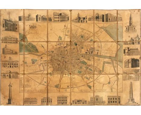
Lot 740
Irish Map: Dublin, [Rocque (John)] A Plan of the City and Suburbs of Dublin by J. Rocque Reduced from his large Plan, engraved for and Sold by L. Elin at Bible in Castle Street & I. Williams, Skinner Row, [P. Halpin Sculp.], with ornate dedication "To George Putland, dedicated and corrected this time 1765", reference list to left, approx. 29 cms x 40 cms ( 11 1/2" x 15 1/2 ") pasted down, unframed. Scarce. (1)Ref: Law, G1b (ii)
Lot 741
Map of Dublin with Attractive EngravingsIrish Map: Dublin - Cooke (J.) Arch & Surveyor Cooke's Royal Map of Dublin, dedicated by Special Permission to His Most Gracious Majesty King George the Fourth on His Visit to Ireland in August 1821, hand coloured, Dublin 1822, the border decorated with various engraved vignette of landmark buildings in the city, approx. 50cms x 72cms (20" x 28"), worn. Scarce. (1)


-
109182 item(s)/page