We found 109182 price guide item(s) matching your search
There are 109182 lots that match your search criteria. Subscribe now to get instant access to the full price guide service.
Click here to subscribe- List
- Grid
-
109182 item(s)/page


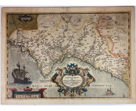
Lot 697
SPAIN -- "VALENTIÆ REGNI, olim Contestanorum Si Ptolemaeo, Edentanorum Si Plinio Credimus Typus". (Antwerp, Ortelius, n.d. (between 1584 and 1592)). Engr. map in cont. colouring and gold heightened. 390 x 540 mm. (Laid down on cardboard, hence v° could not be inspected). First, rather scarce state (of 2). V.d. Broecke, Ort29. -- Added: "REGNI VALENTIÆ TYPUS". (Amst., Mercator/Hondius, 1634). Engr. map in cont. colouring, w. large title cartouche, scale indicator, sailing ship and sea monster. 355 x 480 mm. (Lower blank margin a bit frayed). Dutch text on v°. V.d. Krogt I, 6155:1.1 -- And 2 o. (4).

Lot 653
GERMANY -- "COMITATUS BENTHEIM, et Steinfurt". (Amst.), J. Janssonius, (c. 1650). Plain engr. map. 385 x 503 mm. -- "ARCHIEPISCOPATUS TREVIRENSIS Recentissima Delineatio (…) J. de Ram". Amst., (c. 1690). Plain engr. map. 480 x 590 mm. -- "S.R.I. WESTPHALIÆ CIRCULUS, in omnes ejusdem subjacentes provincias (…)". Amst., P. Schenk jr., (c. 1700). Engr. map in cont. colouring. 587 x 500 mm. -- "CHARTE von dem Fürstenthum Ostfriesland". Nuremberg, 1790. Engr. map mounted on linen, cold. by hand. (Colours faded, a bit stained). -- "THURINGIA LANDGRAVIATUS". (Amst.), J. & C. Blaeu, (c. 1650). Engr. map, cold. by hand. 510 x 410 mm. -- And 22 o. of G., incl. 2 plans. (27).

Lot 666
LOW COUNTRIES -- "BRABANTIA". First h. 17th c. Plain engr. map. 237 x 321 mm. Guicciardini Ilustratus, Brabant-5. -- "RHINOLANDIÆ, Amstelandiæ (…)". Amst., H. Hondius, 1629. Engr. map in cont. colouring. 457 x 556 mm. -- "KAERTE van Suyt-Hollants grootste deel vervatende geheel Rijnlandt ende Suytkennemerlandt, (…)". Leiden, P. v.d. Aa, 1724. Plain engr. map. 483 x 585 mm. -- And 13 o. of parts of Holland. (16).

Lot 670
LOW COUNTRIES -- DELFT -- ("KAART FIGURATIEF"). (Amst.), P. Smith, (1702 (?)). Collection of 16 (of 24) engr. views ('randprenten') which surround the so-called Kaart Figuratief of Delft by D.E. v. Bleyswijck, and text-leaf 'Sommiere Beschryvinge der Stadt Delft'. Loose as issued. NOTE:Dirck Evertsz. van Bleyswijck, was commissioned in 1675 to have a map made with accompanying images of buildings and cityscapes. When the map was ready in 1678, it consisted of a bird's eye view, a view of Delft from the west, Delfshaven seen from the Maas, 22 images of buildings, two maps of Overschie and Delfshaven, four family coats of arms of Delft mayors and a short text with a description of the city of Delft. The floor plan with the border prints could be put together into one monumental wall map. Our collection consists also of - a very rare - folded broadside w. instructions on how to arrange the individual prints of this wall map.

Lot 924
ROME -- DESSEINE, F. Beschryving van oud en nieuw Rome. Uit het Fransch en Latyn vert. (d. W. v. R(anouw)). (Vol. 1 only). Amst., F. Halma, 1704. 1 of 3 vols. (28), 160 pp. W. engr. front., engr. ti-vign., 24 text-engr. (incl. 2 headpieces), 62 full-p. engr., & 13 fold./double-p. engr. plates/maps by Goeree, Baptist, Van Vianen, (a.o.) after Goeree. - Bound (as often) with: B. KENNET. De aaloudheden van Rome, of beschryving van de geleerdheyd en opvoeding der Romeynen. Vert. d. W. Sewel. Amst., F. Halma, 1704. W. engr. front., 21 text-engr. (incl. 1 headpiece), 2 fold. maps (1 map rep./piece missing), 10 fold. engr. (1 lge fold.) & 6 full-p. engr. - 2 in 1 vol. Fol. Cont. blind tooled vellum w. raised bands. (Tear in top of spine, corners a bit worn/dam., vellum a bit stained, free endpapers gone, a bit browned). NOTE:First part (complete in itself) of the first & only Dutch translation of a monumental and splendid work on the history of Rome. - Schudt 555; Van Eeghen/v.d. Kellen 578; Kunst op Schrift 91, 96; Kissner 109.

Lot 695
SPAIN -- "PLAN OF THE CAMP OF TARRAGONA" - "AN EXACT DRAUGHT of the Bay and Harbour of Vigo" - "PLAN OF THE CITY AND CASTLE OF ALICANT, besieged by the Chevalier D'Asfeldt, (…)" - (London, 1745). 3 engr. maps by J. Bassire, taken from the atlas to 'Tindal’s Continuation of Mr. Rapin's History of England'. 390 x 475 mm each. (The last of the three mentioned w. a defective lower left margin). -- Added: "INSULA GADITANA vulgo Isla de Cadiz". Amst., C. Allard, n.d. (c. 1700). Engr. map of Cadiz and surroundings. 237 x 282 (paper size). (Margins cropped to plate size). -- And 2 o. (6).
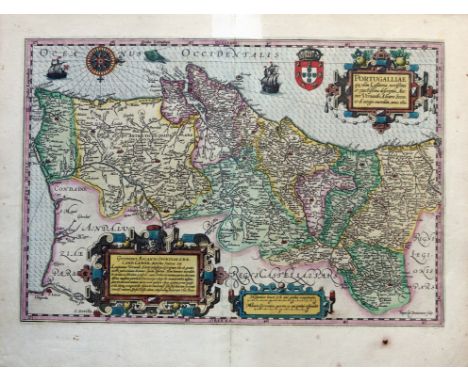
Lot 689
PORTUGAL -- "PORTUGALLIÆ quæ olim Lusitania, noviisima et exactissima desriptio, Auctore Vernando Alvaro Secco, & de integro emendata, anno 1600". (Amst., J. Hondius, c. 1628). Engr. map by Van Doetecom after Alvares Seco in fine cont. colouring w. 3 elaborate cartouches, a compass rose, 2 ships and a seamonster. 341 x 502 mm. (Upper blank margin reinforced on vertical fold, small burn hole in lower blank margin, but in good condition). NOTE:V.d. Krogt I, 6300:1A.

Lot 627
EASTERN EUROPE -- POLAND -- "POLAND AS DIVIDED". (Lond., (etc.), 1817). Engr. cold. map by J. & G. Menzies, taken from Thomson's 'New general atlas'. 453 x 500 mm. -- Added: "SITUAZIONE ATTUALE della Polonia". (Florence), 1831. Engr. map sparsely cold. in outlines after B. Zaydler. 376 x 470 mm. (Multifolded, but in good condition). -- (2).

Lot 163
VELDE, C.W.M. v.d. Reis door Syrie en Palestina in 1851 en 1852. Utr., 1854. 2 in 1 vol. viii, 334; xvi, 429 pp. W. fold. lithogr. map & plan (w. tears), fold. plate & 2 cold. lithogr. views Cont. h. mor. (Spine a bit dam./loosening, front side loose). -- M. NIEBUHR. Travels through Arabia, and other countries in the East. (Repr. ed. 1792. 1968). 2 vols. Ocl. w. dust-j. -- Added: J. BURCKHARDT. Travels in Syria and the Holy Land. Lond., 1822. W. front.-portr. & 5 maps/plans (1 fold.). 4°. Cont. cf. (Without large fold. general map, joints broken/split, some faint stains, a bit foxed). -- (4).

Lot 200
BUDDINGH, S.A. Neêrlands Oost-Indië. Reizen over Java, Madura, Makasser (...) gedaan gedurende het tijdvak van 1852-1857. 2de uitg. Amst, Wed. J.C. v. Kesteren & Zn., 1867. 3 vols. (6) ,415; (6), 415; (8), 445 pp. W. fold. cold. lithogr. map, tinted lithogr. portr. & 27 cold./tinted lithogr. plates. Beautiful or. blind tooled & richly gilt dec. cl. (Plates a bit foxed as usual, else very fine). NOTE:Bastin/Brommer 575-577: "This is more than a travelogue, containing as it does information on a wide range of subjects skilfully interwoven into the narrative (...) The combination of an interesting and informed text with so many coloured plates makes Buddingh's Neêrlands-Oost-Indië one of the handsomest of Dutch nineteenth century travel books". - Cat. NHSM I, 248; Landwehr, Bks w. cold. plates, 247; Rouffaer/Muller p.4; Tiele 214.

Lot 1016
DAPPER, O. Naukeurige Beschrijvinge der Afrikaensche Gewesten van Egypten, Barbaryen, Libyen, Biledulgerid, Negroslant, Guinea, Ethiopiën, Abyssinie: Vertoont In de Benamingen, Grenspalen, Revieren, Steden, Gewassen, Dieren, Zeeden, Drachten, Talen, Rijkdommen, Godsdiensten en Heerschappyen. / Naukeurige Beschrijvinge der Afrikaensche Eylanden: als Madagaskar, of Sant Laurens, Sant Thomee, d'eilanden van Kanarien, Kaep de Verd, Malta, en andere. 2e dr. Amst., J. v. Meurs, 1676. 3 in 1 vol. (8), 428; 349, (17); (2), 121, (4) pp. W. lge-fold. engr. map of Africa, 42 double-p./fold. engr. maps/plans/views & 56 text-engrs. Fol. Cont. blind tooled vellum w. raised bands & mor. label. (Stained in places, else a good and complete copy). NOTE:The second revised and best edition (first 1668). Extensive description of the N. African countries (Egypt, Morocco, Tunesia), the Sahara, the West Coast (with the former Dutch colony St.George del Mina), Ethiopia & the various islands like Madagascar, Canaries, Cape Verdies, etc. (incl. the former Dutch settlements like Fort Nassau on Goeree). - Tiele 298; Gay 219.

Lot 487
SCHILDER, G. The world map of 1624 by Willem Jansz. Blaeu & Jodocus Hondius. - Id. Three world maps by Francois v.d. Hoeye of 1661, Willem Janszoon (Blaeu) of 1607, Claes Janszoon Visscher of 1650. - Id. The world map of 1669 by Jodocus Hondius the Elder & Nicolaas Visscher. - Id. & J. WELU. The world map of 1611 by Pieter van den Keere. - Amst., N. Israel, 1977-81. 4 vols. Full size facsimile of the maps involved plus comment. text. Lge-fol. Owrps. - Complete set. Each volume limited to 600 copies.

Lot 758
LINSCHOTEN, HUYGEN VAN. Collection of 11 engraved plates by Joh. & Bapt. v. Doetecom from the 'Itinerario'. (Amsterdam, c. 1600). 11 engr., incl. 1 map of Mozambique. All c. 250 x 320 mm. (2 w. rep. on vertical fold, but in good condition and w. ample margins). NOTE:Collection of engravings to Huygen van Linschoten's famous travels to i.a. Mozambique, comprising the following plates: '6 en 7. Insula & arcis Mocambique' (without description on v°); '32 en 33. Habitus e China regno'; '32 en 33. Lectuli & ratio quibus Chinæ proceres'; '32 en 33. Naves e China & Java'; '46 en 47'. Naves cæloces seu biremes'; '60 en 61. Æthiopum e Moçambyque, etc.'; '61 en 62. Naute Arabes'; '64 en 65. Cochini Rex elephante vectus'; '64 en 65. Inquilini e Cananor Mahometani infectiss.'; '86 en 87. Ecce tibi ramum, etc.'; 86 en 87. Arundo Indica'. - Tiele, Mémoire, 87-8.
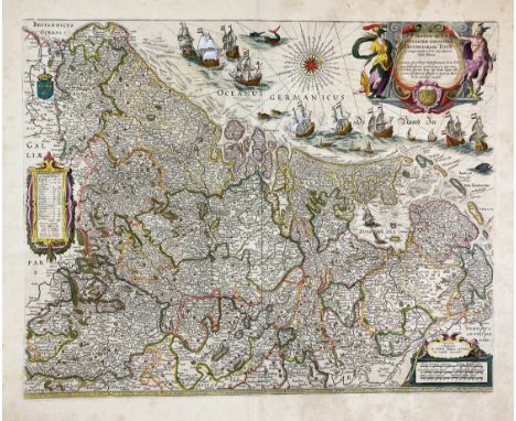
Lot 679
LOW COUNTRIES -- "NOVUS XVII INFERIORIS GERMANIÆ PROVINCIARUM TYPUS de integro multis in locis emendatus à Guliel. Blaeu". Amst., W. Blaeu, (1662). Engr. map, cold. by hand, w. large title cartouche, a compass rose, several ships at sea and sea monsters. 405 x 514 mm. (3 small holes in upper blank margin, a bit browned/foxed, but a good copy). NOTE:Third state, text in Latin on v°. - V.d. Krogt 3000:2.2; Van der Heijden 64.2.


Lot 1029
(LAT, J. de). Nieuw en Beknopt Kaart-Boekje, vertoonende de XVII. Nederlandse Provintien. Deventer, Joan de Lat, 1741. (16) pp. W. a fold. general map of the Netherlands, 22 fold. maps and 2 distance tables, all nicely cold. by hand. Narrow-8°. Cont. h. roan. (Some maps split on folds, some small rep. to last distance table, slightly browned, but a good copy). NOTE:Koeman II, Lat1a, note.
Lot 95
FREDERIKSOORD -- DE STAR, een tijdschrift, uitgegeven van wege de Permanente Kommissie der Maatschappij van Weldadigheid. 1e dl., 1e stuk. Amst., J. van der Hey, 1819. (8), 549 pp. W. 2. handcold. costume plates, 1 fold. handcold. map of India & 4 fold. tables. Cont. hcf. NOTE:Rare first part of the first volume of this monthly magazine, published by the 'Permanente Commissie van de Maatschappij van Weldadigheid', mainly by the founder (Johannes van den Bosch) and the secretary (Willem Anthonie Ockerse), to inform the donors what the 'Maatschappij' spend their money on. At the beginning of the 19th century, a large-scale social experiment took place in the United Netherlands, with as purpose: to end poverty. Since 1818, the 'Maatschappij van Weldadigheid' buys up large, uncultivated tracts of land. Seven Colonies of 'Weldadigheid' were established there in seven years. The publication of the magazine ends in 1826 after the death of Ockerse. In 2007 'De Star' is revived by the former director Jan Mensink a.o.

Lot 1028
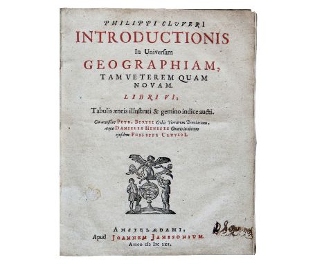
CLUVERIUS, Ph. Introductionis in Universam Geographiam, tam Veterem quàm Novam libri VI. Amst., J. Janssonius,1661. (8), 142; (2), 31, (1) pp. W. 45 fold. maps, 1 fold. engr. wind chart, & 1 table. Sm-4°. Cont. vellum w. overl. sides. (Bind. a bit soiled, name entries on paste down & title, first free endpaper gone, 1 map rep. in lower margin, some marg. stains, a few underl. in an old hand, but else a good copy). NOTE:Philip Cluver (Cluwer or Cluvier) (1580-1623), German geographer and historian, was given a special appointment at Leiden as geographer and put in charge of the university's library. His life's project was a general study of the geography of Antiquity, based not only on classical literary sources, but - and this was his contribution - supplemented by wide travels and local inspections. He became virtually the founder of historical geography. The first edition of this work appeared in 1624 (without maps) and many editions followed. Another edition with only 38 maps (in duodecimo) was also published in 1661 (Amst., Elzevier). - Sabin 13805; Shirley 426.

Lot 676
LOW COUNTRIES -- "NAEUKEURIGE NIEUWE LAND-CAERT des Graefschaps Zeeland". Leiden, Chr. Vermey, (1718). Engr. map of the province of Zeeland. 455 x 535 mm. 2nd state. -- Added: "MIDDELBURGHUM". Amst., F. de Wit, (1698). Engr. plan of the city. 420 x 530 mm. (Lower outer right corner w. small tear running into image and partly trimmed to plate edge). Fine plan w. lots of details. -- And 2 o. w. relation to Zeeland, incl. a plan of Vlissingen. -- (4).
Lot 381
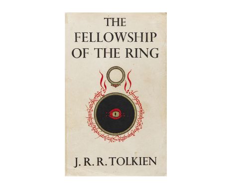
TOLKIEN, J.R.R. The Lord of the Rings. London, George Allen & Unwin Ltd., (1955). 3 vols. W. fold. map in each vol. Ocl. w. dust-j. (Cloth stained and spine ends/corners first 2 vols. a bit dam., dust-jackets partly dam./rep. w. Sellotape, spines browned, price-clipped). NOTE:First edition: The Fellowship of the Ring (2nd impression) The Two Towers (2nd impression) The Return of the King (1st impression).


Lot 950
BIBLIA NEERLANDICA -- (MARTIN, D.). Historie des Ouden en Nieuwen Testaments. (Vert. d. W. Séwel). Amst., P. Mortier, 1700. 2 vols. (18), 282, (8); (26), 163, (11) pp. W. 2 variant engr. fronts., lge. engr. vign. on each ti., 32 engr. head- & tailpieces, 5 engr. double-p. maps (incl. a world map & 3 indexes) & w. c. 428 illustrations on 214 engr. plates. Lge-fol. Cont. h. goatskin. (Slightly rubbed boards, vol. 1 w. 2 small tears in blank margin, vol. 2 w. faint marg. stain in the prelims, else a fine set). NOTE:So-called 'Grote bijbel van Mortier'. One of the finest illustrated bibles produced in the Netherlands with engravings after Luyken, Picart/d, Goeree, Tideman, Hoet by Baptist, Blois, Mulder a.o. On this luxurious bible cf. Van Eeghen/v.d. Kellen 351; Klaversma/Hannema 180, 187; Poortman II, 98-105.


Lot 133
Collection of military cap badges and Staybrite (inc 17/21st Lancers, Calgary Highlanders, SAS Artists, Kings Own Malta Regiment, Drake, RNAS, Kings African Rifles, First Surrey Rifles), buttons, pips, cigarette cards, albumen military soldier photographs, map and embroidered vintage handkerchiefs, etc.


Lot 440
ELEVEN MODERN FRAMED NEEDLEWORK PICTURES ETC, subjects include a coaching scene, a unicorn hunting scene, fox hunting scene, floral still life etc, largest approximate size 38cm x 109cm excluding frame, together with a framed Bartholomew's map of Birmingham, religious print, picture frame and a Sectric & Mains parrot themed wall clock converted to battery, some losses to the parrot
Lot 443
A QUANTITY OF PICTURES AND PRINTS ETC, to include an etching by Henry Wilkinson 'Patience' depicting two hunting dogs, three textile pictures by Cherrilyn Tyler, woodland watercolour by Peter Hodson, Robert Morden map of Warwickshire, a vintage butterfly wing picture, an oil on canvas depicting a river landscape indistinctly signed, carved wooden African panel, assorted pictures etc
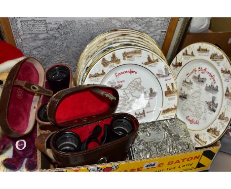
Lot 468
A BOX AND LOOSE MAPS, PLATES AND BINOCULARS ETC, comprising two framed facsimile maps: 'A Picture Map of Birmingham in 1730 Imagined & Drawn from City Records by Bernard Sleigh' and 'Saxton's Map of Worcestershire, 1577', largest frame 51.5cm x 39cm, together with ten 'Edwardian' China collectors plates depicting coalfields, cased Ross 7 x 42, and Telemax 5 8 x 40 binoculars, and a metal trinket box with relief figures in a rural landscape (1 box + loose) (sd)


Lot 606
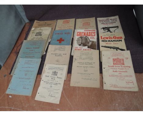
Twelve WW2 Military Booklets, Browning Heavy Machine Gun Mechanism Made Easy, Lewis Gun Mechanism Made Easy, Grenades For The Home Guards, Small Arms Training x3 Vol1 no2 ,no3 and no6, Tactical Handling of Flame Throwers, First Aid, Elementry Map Reading, Field Service Pocket Book part 1 no 13, Infantry Training x2 part 5, vol 1 no 2 and Notes on Map Reading


Lot 173
Original vintage travel advertising poster for Southern Railway Island & Mainland Connections, the poster features a map of Isle of Wight with smaller insets of The Solent, Southampton, Portsmouth, Lymington, and Southern Railway & Continental Connections with the English Channel and France. This poster reproduces the map originally issued by the British Railways. Horizontal. Poor condition, folds, tears, creasing, staining, tape marks, paper skimming, small paper losses. Country of issue: UK, designer: Unknown, size (cm): 25x63, year of printing: 1940s.

Lot 176
Original vintage poster - Illustrated Map of the Holy Land for Use in Schools Issued by the National Savings Movement, this poster has been designed for use in schools and shows many of the historic towns in the Holy Land. The illustrations have been based on events from the Old and New Testaments and have been placed, where possible, in geographical position, except where a number of important events have taken place in a small area. It is interesting to record that some of the illustrations of the towns have been adapted from engravings in Cassell, Petter and Galpin’s illustrated Bible published over a century ago. – The map features Mediterranean Sea or The Great Sea, The Dead Sea, modern Israel and Palestine territories and the Eastern Bank of the Jordan River. Issued by the National Savings Committee. Printed for H.M. Stationery Office by UDO Litho Limited, London. Good condition, creasing, tears, minor staining. Country of issue: UK, designer: Mahoney, size (cm): 101x76, year of printing: 1950s.

Lot 181
Original vintage travel advertising poster for Trips, Cruises in the Canary Islands / Voyages, Croisieres aux Iles Canaries, featuring an illustration of a gentleman playing a guitar and smoking a pipe and a lady in traditional clothing dancing under a palm tree with a map marking Santa Cruz de Tenerife, Las Palmas, Casablanca, Tangier, and Marseille, with a silhouette of a cruise ship Paquet. Acceptable condition, tears, creasing, paper losses, staining, pencil mark on bottom edge. Country of issue: France, designer: J. Tonelli, size (cm): 49x32, year of printing: 1950s.
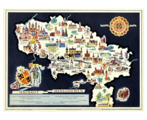
Lot 200
Original vintage travel poster for Hainaut Henegouwen in Belgium featuring a colourful pictorial map by Philippe Dumont and J. Ado Baltus depicting the Hainaut province marking the capital Mons or Bergen in Dutch and Charleroi, depicting castles, factories, and tourist places of interest, with an astrological sign compass above and a knight in armour standing with a flag next to the coat of arms, set over dark background. Horizontal. Very good condition, creasing. Country of issue: Belgium, designer: Ph. Dumont, J.A. Baltus, size (cm): 29x40, year of printing: 1950s.

Lot 201
Original vintage travel poster for Brabant in Belgium featuring a colourful pictorial map by Philippe Dumont and J. Ado Baltus depicting the Brabant province marking the capital Brussels, depicting castles, churches, cathedrals, and tourist places of interest, with a knight in armour and lady with a book standing next to the flag of Brabant, set over light background. Horizontal. Very good condition, creasing. Country of issue: Belgium, designer: Ph. Dumont, J.A. Baltus, size (cm): 29x40, year of printing: 1950s.

Lot 202
Original vintage travel poster for Atwerpen Anvers in Belgium featuring a colourful pictorial map by Philippe Dumont and J. Ado Baltus depicting the Antwerp province marking the capital Antwerp, depicting castles, churches, cathedrals, and tourist places of interest, with the coat of arms below the image set over light background. Horizontal. Excellent condition. Country of issue: Belgium, designer: Ph. Dumont, J.A. Baltus, size (cm): 29x40, year of printing: 1950s.

Lot 203
Original vintage travel poster for Liege Luik in Belgium featuring a colourful pictorial map by Philippe Dumont and J. Ado Baltus depicting the Liege province marking the capital Liege, depicting castles, churches, cathedrals, and tourist places of interest, with the coat of arms below the image set over green background. Horizontal. Very good condition, creasing. Country of issue: Belgium, designer: Ph. Dumont, J.A. Baltus, size (cm): 29x40, year of printing: 1950s.
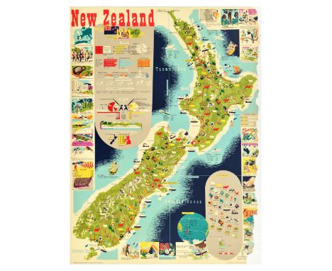
Lot 219
Original vintage travel poster for New Zealand, featuring a great colourful pictorial map of North, South and Stewart islands, surrounded by the Pacific Ocean, with informative insets with statistics on the population, birth rate, infant death rate, life expectancy, education, livestock population, value of production 1949-1950, trade in 1950, geographical features, comparison of populations of New Zealand and United Kingdom; image insets showing the map of New Zealand, Treaty of Waitangi, kiwi bird, Parliament, sub-tropical trees, tuatara, mountaineers, Maori canoe prow, war effort, major places of interest and a key to the pictorial map. Produced by Publicity Division, Department of Tourism and Publicity, N.Z. Government. Printed in Great Britain. Poor condition, several paper losses on right edge, creasing, tears. Country of issue: UK, designer: H. Mallitte, size (cm): 102x75, year of printing: 1951.
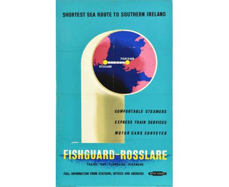
Lot 233
Original vintage travel advertising poster for British Railways Fishguard-Rosslare Shortest sea route to Southern Ireland, Comfortable steamers, Express train services, Motor cars conveyed. Trains run alongside steamers. The poster features an illustration of a ship's funnel showing the map with a connection between Rosslare and Fishguard. Good condition, folds, creasing, tears, pinholes, minor staining. Country of issue: UK, designer: Lender, size (cm): 101x63, year of printing: 1960s.
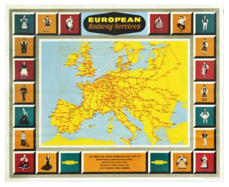
Lot 240
Original vintage railway travel map poster - European Railway Services for tickets and further information please apply to British Railways Continental Enquiries Offices Victoria Station London SW1 Liverpool Street Station London EC2 or to principal travel agencies - featuring a map of Europe in yellow with the extensive route lines marked in red between the various cities marked in black text and connection ferry services marked in dashed white lines over the blue sea, the map surrounded with colourful images in 20 boxes depicting people dressed in the traditional national costumes of the European countries including a man in uniform and people dancing with the stylised title text above and the information below with the British Railways logo on each side. Published by the Southern Region of British Railways. The Haycock Press Ltd London SE5. Horizontal. Large size. Good condition, folds, creasing, small tears, minor staining. Country of issue: UK, designer: Unknown, size (cm): 101x127, year of printing: 1960s.
-
109182 item(s)/page