We found 109182 price guide item(s) matching your search

Refine your search

Year

Filter by Price Range
  • List
  • Grid
  • 109182 item(s)
    /page

Lot 329

Walker (J & C), A Geological Map of England, Wales and Part of Scotland Showing also the Inland Navigation with the Rail Roads and Principle Roads, hd col engr map, sectionalised and laid on linen, geological profiles along top and base of map, 145 x 100cm, contained in cl book box.

Lot 285

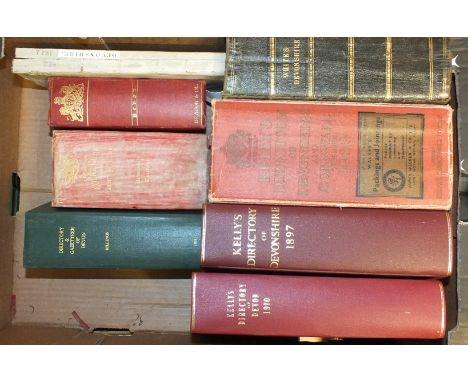
Botanista (Theophilus, pseud.), Rural Beauties; Or The Natural History of the Four Following Western Counties......., engr frontis, fldg map, re-backed cf gt, 16mo, 1757; The Gazetteer of the County of Cornwall, linen-backed, fldg map, rebound hf mor gt, 18mo, nd and other volumes, similar, (6).

Lot 295

Worms (Lawrence), and Baynton-Williams (Ashley), British map engravers, illus, dwrps, cl gt, 8vo, 2011 and other books on maps.

Lot 390

A 'Great Western Railway Plymouth Great Western Docks' map printed on linen, 40 x 40.5cm, a Railway System 1902 map for Midland, Southern England & Wales, 35 x 48cm and a Bartholomew's Revised half-inch map of Dartmoor, 55 x 83cm, (all framed), (3).

Lot 71

Millais (J G), Far Away Up the Nile, cl gt, 8vo, 1924; Melland (Frank H) and Cholmeley (Edward H), Through the Heart of Africa, fldg map, plts, pic cl gt, (af), 8vo, 1912 and other volumes, similar, (5).

Lot 308

Cary (John), Cary's Traveller's Companion or a Delineation of the Turnpike Roads of England and Wales, engr tp, hd col engr fldg map of Yorkshire, 42 hd col engr maps, rebacked, hf cf gt, 12mo, 1821.

Lot 228

Smyth (Capt. William Henry), Memoir Descriptive of the Resources, Inhabitants and Hydrography of Sicily and Its Islands Interspersed with Antiquarian and Other Notices, fldg map, 14 aquatint plts, (lacks view of St Johns Church), rebound, hf mor gt, with orig marbled bds, 4to, 1824.

Lot 56

Lloyd (Henry Humphrey Evans), A Political and Military Rhapsody on the Invasion and Defence of Great Britain and Ireland, 1 fldg map, 2 fldg plts, rebacked, cf gt, 8vo, 5th edn, 1798.

Lot 233

Hamilton (William Richard), Remarks on Several Parts of Turkey, in 2 pts: Pt 1, Aegyptiaca or Some Account of the Ancient and Modern State of Egypt, As Obtained in the Years 1801, 1802, fldg engr map; Pt 2, twenty-four fldg plts by J Powell, rebound cl gt, 4to, 1809, Ex Lib (Bath Munic. Ref. Lby), some pages and most of the fldg plts bear a lby blind stamp.

Lot 388

Romana De Hooghe, a large copper-engraved hand-coloured map, "The English Riviera" Carte Maritime D'Angleterre, hand-coloured and framed.

Lot 537

A child's dirndl dress and blouse, two map jigsaws (unchecked), playing cards and other items.

Lot 167

Cox (Rev. Thomas), Magna Britannia - Devon, pp465-546, later tp, engr hd col fldg map by Robert Morden, hf mor gt, sm 4to, 1720 and another copy, with Dorset bound-in, 2 fldg maps, (not coloured), no tp, hf cf gt, sm 4to, nd, (2).

Lot 309

Owen (W), Owen's New Book of Roads or a Description of the Roads of Great Britain, 2nd edn, facsimile map, rebound hf cf gt, 12mo, 1779; also Owen's New Book of Fairs, hf cf gt, 12mo, 1813.

Lot 289

Desnos (Louis Charles), Senex (John) and Bellin (Jacques), Nouvel Atlas D'Angleterre 1767 bound with The Roads Through England or, Ogilby Survey (titled in French as well), 1766 and Recueil de Villes Ports D'Angleterre 1766, 3 vols bound in one: Nouvel Atlas, engr tp, 10 hd col engr maps, 2 of French coast, "Roads Through England", engr map of England, 101 engr road maps; Recueil: 18 engr maps and city plans, hf cf gt, 4to, 1766-67.

Lot 147

Borlase (William), The Natural History of Cornwall, reprint, 2nd edn, limited to 350, fldg map, teg, dwrp, cl gt, fo, slip case, 1970.

Lot 144

Deacon's Court Guide, Gazetteer and County Blue Book - Survey of Devonshire, fldg map, ge, cl gt, 8vo, 1st edn 1882, another, 1896 and other similar directories by William White, M Billing, Pigot, Kelly, etc, (9).

Lot 370

Green, James, Map of the Turnpike Road from Plymouth to Exeter 1819, J Cary Sculpt, 29 x 102cm, also A New and Correct Map of the Roads of England, South Britain, from Ogilby's Survey, 32 x 29cm.

Lot 189

Carrington (H E), Plymouth and Devonport Guide, fldg map frontis, tp repaired, 5 fldg plts, mor gt, 32mo, 1828 and three other guides, Devon and Cornwall.

Lot 178

Rowe (Samuel), A Perambulation of the Ancient and Royal Forest of Dartmoor, fldg map, plts, rebound cl gt, 8vo, 1848; Carrington (NT), Dartmoor, A Descriptive Poem, plts, me, hf mor gt, 8vo, 1826 and another volume, Dartmoor, (3).

Lot 161

Maton (William George), Observations Relative Chiefly to the Natural History, Picturesque Scenery and Antiquities of the Western Counties of England..... 1794 & 1796; 2 vols in 1, fldg map, 16 oval aquatints, hf cf gt, 8vo, 1797.

Lot 552

A framed silver map by The Royal Geographical Society, London hallmark for 1976, 37 x 56cm.

Lot 192

Izacke (Richard), Remarkable Antiquities of the City of Exeter, now very much enlarged and continued to the year 1723, by Samuel Izacke, engr frontis, fldg map, fldg view of Exeter Cathedral, armorials to text, ge, re-bound mor gt by Riviere, 8vo, 1724.

Lot 369

William Kipp, a 17th century map of Cornwall, hand-coloured, 31 x 40cm and other coloured and uncoloured maps and charts.

Lot 162

Fraser (Robert), General View of the County of Devon, fldg map, hf mor gt, 8vo, 1794; De La Beche (Henry), Report on the Geology of Cornwall, Devon and West Somerset, 13 plts, many fldg, cl gt (a/f), 8vo, 1839 and other volumes, (6).

Lot 324

Chauchard (Capt Jean Baptiste Hippolyte) A General Map of the Empire of Germany, Holland, the Netherlands, Switzerland, The Grisons, Italy, Sicily, Corsica and Sardinia, tp, calligraphic dedication page, index sheet, 25 d-p maps including 2 index maps, John Stockdale, City of Leeds Libraries book plate, hf mor gt, fo, 1800.

Lot 381

Ortelius, Abraham, Sicilae Veteris Typus, 1696, early colour, centre fold, inset map of Syracuse in top left corner, text box in lower left corner, broad margins, image 46.5 x 34.2cm.

Lot 303

Donn (Benjamin), A Map of the County of Devon with the City and County of Devon with the City and County of Exeter, hd col map of Devon, 11 hd col dp maps of Devon Hundreds and one uncoloured dp map of Plymouth and Stoke Towns, Citadel and Dock, rebound hf cf gt with orig bds, bookplate of Frederick Pollock, fo, 1765.

Lot 107

Hamilton (Sir William), Observations on Mount Vesuvius, Mount Etna and other Volcanos in a Series of Letters, fldg map, 5 plts, rebound hf cf gt, 8vo, 1772.

Lot 468

C SMITH: A NEW MAP OF THE COUNTY OF DORSET divided into hundreds, dated 1804

Lot 503

AN ANTIQUARIAN MAP OF DORSETSHIRE

Lot 474

Large terrestrial map decorated low centre table

Lot 249

Cary's Traveler's Companion, pub. London 1790, 41 UK county maps, bound in original red leather, one map lacking

Lot 465

J Blaeu Map of Staffordshire, circa 1645, French text verso, contemporary hand-colouring, info verso

Lot 309

Quantity of books on fishing including:-Shipley, Williams & Fitzwilliam "A True Treatise on the Art of Fly-Fishing, Trolling, etc....", edited by Edward Fitzgibbon, Simpkin Marshall & Co 1838, frontis, name inscribed on title page and on ffep dated 1849, blindstamped cloth with gilt titles on backstrip, top of backstrip chipped Gallichan, Walter M (Jeffrey Mortimer)"Fishing and Travel in Spain, a guide to the angler", F E Robinson & Co 1904, photographic frontis with tissue guard, photographic plates, hinges cracked, inscription on ffep dated 1909, gilt titles and decorations on red clothThe New Naturalist LibraryFront, W E & Brown, M E "The Trout", Collins 1967, inscription on ffep, green cloth, dj not price clippedStoddart, Thomas Tod"The Angler's Companion to the Rivers and Lochs of Scotland", 2nd edition, William Blackwood & Sons 1853, engraved frontis, illustrations, stitched pocket in back board with a folded map and various other related volumes, also "The Trout and Salmon Magazine" dating from the 50's, 60's, etc. in green bindings

Lot 486

Robert Morden (1695-1722)Engraved map of Oxfordshire, framed and glazed

Lot 472

Modern framed map of Somersetshire and Wiltshire after John Carey, framed map of Glocestershire after John Speede, the paper is creased and stained dark, map after Willem Janszoon Blaeu "A New Description of Africa 1631" printed after the Folger Shakespeare Library (4)

Lot 489

Jan Jansson Map of Northamptonshire, engraved map circa 1650, framed and glazed in Hogarth frame

Lot 493

18th century Dutch coastal strip map of "Dunwich, Aberdeen", "Sunderland", etc., 'No.V' to top right corner and Josiwo to bottom right corner, 47cm x 30cm

Lot 466

John Ogilby Strip map, circa 1675, the Road from Oxford to Chichester, hand-coloured

Lot 487

Robert Morden (circa 1695-1722)Engraved map of North Wales, hand-coloured, framed and glazed

Lot 123

Five Bartholomew's maps, the 'Latest Indian Railways' Guide a Multicolour Map' published by Makhija & Bros, Delhi and various topographical engravings of country houses, etc.

Lot 467

Saxton Hole map of Carnarvon, second edition, published 1610, hand-coloured (info verso)

Lot 115

MAP OF BUCKINGHAM & COLOUR PRINT OF HORSE & JOCKEY

Lot 489

FOLDER OF LUCAS 29 SECTION ROAD MAP FOLDER

Lot 189

M. M. Rudge, Leicester Cathedral, an etching, 14 x 9cm, an Ordnance survey map, West Leicester 1887 and a facsimile of Spencer's New Map of Leicester 1879, (3).

Lot 270

Three reproduction pistols and a reproduction map of Leicester, (4)

Lot 399

Col. Barry's map of the Pytchley Hunt 1911, printed for Private Circulation, Stamford's London, 61x68cm.

Lot 405

Colourprint map, Northamptonshire, reprint; collection of other Northamptonshire maps and prints.

Lot 1

An 18th century Thomas Kitchen framed map of Hartfordshire.

Lot 2

An eighteenth century framed map of Somerset by Emanuel Bowen.

Lot 43

Ceasarea: Or, An Account Of Jersey by P. Falle c1734. printed by T. Wotton, London, 2nd edition, missing map a/f..

Lot 492

John Speed Uncoloured engraved mapEngland, Wales and Ireland (Speed, John)"Invasions of England and Ireland with all their Civil Wars since the Conquest", uncoloured engraved map, 38.7cm x 51.5cm

Lot 464

"Facsimile of the Ordnance Survey Surveyors Drawings of the London Area 1799-1808, Map of the Geology and Contours of London and its Environs by R W Mylne" and other reproduction maps and drawings, unframed

Lot 835

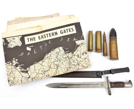
A US Model 1892 bayonet for the Krag Jorgensen rifle, the blade dated 1899, in its scabbard with steel belt attachment, GC; a WWI German 37mm pom pom shell case with explosive shell in fired condition; 3 other small shell cases; 11 1940 War Edition linen backed OS maps, mostly of northern England; 3 similar part maps of Moscow, Berlin and Frankfurt; 2 other maps; and a map/poster, “The Eastern Gates”, of the Baltic States etc, and on the other side a propaganda poster showing caricature sketches of the German leaders, photographs of the Russian and allied leaders, map of Europe etc. Average GC

Lot 333

17th century English Schoolcoloured engravingMap of Glamorgan30 x 36cm.

Lot 320

1889 ETHNOGRAPHIC MAP of GREAT BRITAIN AND IRELAND – Superb detailed antique map 14”x19” (JOHNSON’S ATLAS) small stains lower border

Lot 344

Surrey Woking Oaklands Goldworth Road 1900 10th October vellum mortgage document Mr H Shuttleworth to Mr A Simmonds includes map signed and sealed three pounds and also five shillings embossed stamps

Lot 394

Surrey Woking & Ripley with the surrounds Homeland Handbooks no 42 much advertising 81pp and ordnance Map

Lot 395

Surrey Woking an illustrated guide to Woking & surrounding district. Pub Chamber of Trade 1951 pp80 includes map and many period advertisements

Lot 399

Map Railways of Great Britain 1906 hard cover stamped Great central Marylebone 28 May 1908

Loading...Loading...
  • 109182 item(s)
    /page

Recently Viewed Lots