We found 109182 price guide item(s) matching your search
There are 109182 lots that match your search criteria. Subscribe now to get instant access to the full price guide service.
Click here to subscribe- List
- Grid
-
109182 item(s)/page
![John Speede, original hand coloured map of 'Caermarden', [sic] Hogarth framed and glazed. (B.P. 24% incl. VAT)](https://cdn.globalauctionplatform.com/2c284f73-4b6b-4005-af7b-a7c100d5e8c3/3151bdc6-42b5-4266-b2e6-8e47a10d75b1/468x382.jpg)


![After John Speede, a facsimile modern map of 'Breknoke' [sic], together with after Samuel and Nathaniel Buck, two small castl](https://cdn.globalauctionplatform.com/2c284f73-4b6b-4005-af7b-a7c100d5e8c3/1217efb4-1b84-4e95-8616-b24fbd64e679/468x382.jpg)
Lot 444
After John Speede, a facsimile modern map of 'Breknoke' [sic], together with after Samuel and Nathaniel Buck, two small castle prospects: 'The South East View of Breknock Castle' and 'The North View of Morlashe Castle, in the county of Glamorgan'. Framed and glazed. (3)(B.P. 24% incl. VAT) CONDITION REPORT: Print of Brecon castle: No obvious tears or losses. Little or no side margins - plate marks. Under the frame at the sides.
![John Speede, an original hand coloured map of Breknoke [sic], Hogarth framed and glazed. (B.P. 24% incl. VAT)](https://cdn.globalauctionplatform.com/2c284f73-4b6b-4005-af7b-a7c100d5e8c3/4492085e-b653-4c46-fc39-b3578afdb99a/468x382.jpg)

Lot 123
An interesting early 19th Century scrapbook, inscribed 'Philip Musgrave 1837', thought to relate to Philip Musgrave (1833-1859), son of Sir George Musgrave, High Sheriff of Cumbria in 1840, the album containing a wide selection of watercolour scraps including a map of Bedfordshire (where Philip Musgrave was born) Good overall condition Provenance: this album given to the mother of the vendor by Maud Graham (sister of Rector Ivor Graham) 'for her children' whilst she was in their service at the rectory of Arthuret Parish Chuch, Longtown, Cumbria


Lot 31
James Joseph Lloyd Carr (1912-1994) - Limited edition colour print - Historical map of Cumberland, to mark the Queens Silver Jubilee, 62cm x 40cm, No. 114 of 777, signed and with publisher stamp, in gilt frame and glazed, two small Cumbrian related oil paintings and a print of West Walls Deanery Print slightly faded Note: Surely a rarity, this historical map was produced by J.L. Carr Publishers, an independent publishers founded and run by novelist and publisher James Carr based in Ketting, Northamptonshire. For further information, see the Obituary by D.L. Taylor published in the Independent, 28th February 1994
![A quantity of Lake District related books, including Wainwright [Alfred], 'The Central Fells', 2nd impression 1958 (with dust](https://cdn.globalauctionplatform.com/b54c7539-9668-4863-b7a2-a7bd010ddfc1/c76fb99f-5a21-4153-ed1e-5d88bae95cd9/468x382.jpg)

![Johannes Jansson [Janssonius] (1588-1664) - Coloured engraving - Map of Essex, 38cm x 48cm, in Hogarth frame and glazed, with](https://cdn.globalauctionplatform.com/b54c7539-9668-4863-b7a2-a7bd010ddfc1/37e31773-aa9d-4fd1-cacc-379afda8b357/468x382.jpg)


Lot 773
GENTLEMAN'S CORUM STAINLESS STEEL BUBBLE AUTOMATIC WRIST WATCHthe round blue dial with world map in red, green and yellow, with applied stainless steel numerals, outer dot seconds track, domed crystal, the 43mm case with 383.150.20, 738286 to the reverse exterior, on a black strap with a Corum clasp, lacking box and papers

Lot 774
MID SIZE MICHAEL JORDI GENEVE BI COLOUR STAINLESS STEEL AUTOMATIC WRIST WATCHthe round silver coloured dial with coloured map, dot hour markers, date aperture at 3, outer raised Arabic numeral seconds track, the gold coloured bezel with city names in black, the 37mm case with crystal section to the centre with movement visible beneath, on a blue strap, with Michael Jordi clasp, lacking box and papers

![A group of 12 assorted prints and watercolours, including a map of Oxford, Buckingham and Bark-shire [sic] and one oil on boa](https://cdn.globalauctionplatform.com/33b68e00-38e1-449d-aa16-a7c500b0f057/1fcff233-9f15-4173-9872-566822b4c729/468x382.jpg)
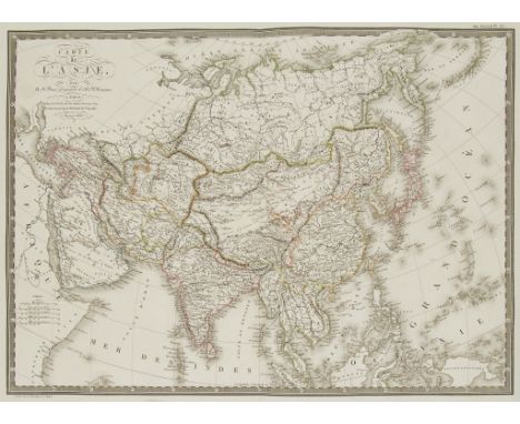
Lot 147
Brue (Adrien Hubert) Carte de l'Asie, general map of the continent, along with 4 other maps of Asia Minor, Russia in Asia, Turkey in Asia and Turkey in Europe, all from the Atlas Universel, 5 engraved maps with original outline hand-colouring, each c.400 x 545mm., or the reverse, each with a central fold, full margins and publisher's blindstamp, Paris, 1820-22; with a D'Anville-Schraembel map of the Tigris and Euphrates, 1786; a small map of Asia Minor by Vander Aa; and a group of 9 'Patent Illuminated' maps of the Middle East in biblical times, by Charles Knight & Co. after W. Hughes (16)

Lot 264
Ogilby (John). The Road from London to Montgomery North Wales, hand coloured strip road map, probably late 17th century, 44.5cm x 32cm; after Leonard Knyff, Newnham Padox (sic) Warwickshire, the seat of the Rt. Hon.ble Basill Feilding, double-page engraved bird's eye view with coat-of-arms, engraved by Johannes Kip 35cm x 48cm and Warwickshire. Saxton (Christopher & Kip, William), Warwici Comitatus a Cornauiis olim Inhabitatus, coloured and engraved map, strapwork title cartouche, separate scale of distance surmounted by dividers, 29cm x 35cm


-
109182 item(s)/page