We found 109198 price guide item(s) matching your search
There are 109198 lots that match your search criteria. Subscribe now to get instant access to the full price guide service.
Click here to subscribe- List
- Grid
-
109198 item(s)/page


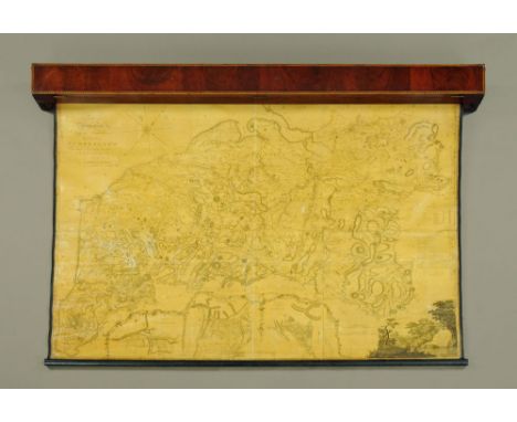
Lot 1059
A George III antiquarian map of The County of Cumberland by Thomas Donald, at the request of the late Mr Jefferys Geographer to the The King and engraved by J Hodgkinson 1783, and contained within a period map case. Map dimensions +/- 114 cm x 164 cm (see illustration). CONDITION REPORT: The map is mounted on linen. The condition is generally fairly good considering the age of the piece. There are numerous small creases and minor scuffs but no large tears or losses. The worst affected area is bottom left near Whitbeck just below the numeral 15. The map does appear to have a varnished finish but again this is in generally good order with no significant discolouration. The edges of the map are slightly dirtier than the centre. There is a visible crease line down the centre running from the right of the S on Solway down to the bottom scale.

Lot 601
After Christopher Saxton, a hand tinted map of Herefordshire, after the original dated 1577, framed and glazed. 39 cm x 53 cm. CONDITION REPORT: This is a copper plate engraving. There is discolouration throughout. Later handcolouring. Edges trimmed to the print. This copper plate engraved map has trimmed edges, later hand colouring and discolouration to the paper in areas. The print appears to be stuck down to the cardboard backing at the corners but possibly in other areas also.


![Cary (J), CARY'S SURVEY OF THE HIGH ROADS FROM LONDON TO HAMPTON COURT [...] RICHMOND ON A SCALE OF ONE INCH TO A MILE : WHER](https://cdn.globalauctionplatform.com/aa975ce7-035d-424a-901a-ae4c011e831d/d8328eb4-c9a2-4b5a-a950-ae5300ffbb85/468x382.jpg)
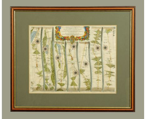
Lot 321
Cary (J), CARY'S SURVEY OF THE HIGH ROADS FROM LONDON TO HAMPTON COURT [...] RICHMOND ON A SCALE OF ONE INCH TO A MILE : WHEREIN Every GENTLEMAN'S SEAT, situate on, or seen from the ROAD, (however distant) are laid down, with the Name of the Possessor; to which is added the number of INNS on each separate route; ALSO, the different TURNPIKE GATES, shewing The Connection which one trust has with another, 1/2 leather, marbled boards, "Explanation" and "Advertisement" page, foldout engraved "General Map" of London and environs, full-page "General Plan for explaining the different Trusts of the Turnpike Gates.", and eighty hand coloured engraved strip-maps to 40 plates, printed for J Cary, London 1790 (at fault)
Lot 338
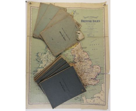
Six Bacon's Excelsior Wall Atlases, each from Part VI of the "British Colonies" series, comprising: Africa, Australia, Canada And West Indies, India, New Zealand, South Africa, and Latitude And Longitude Ocean Routes, with four maps from the "America" series, comprising: North America (Bold Feature), South America (Bold feature), Panama Canal, and United States (Historical), and six maps from Part IV of the "British Isles" series, comprising: British Isles, England, Ireland, Scotland, Wales, Australia, and New Zealand, each six panel linen-backed map with punched brass hanging rings to top corners, each map 100cm x 75cm (17)
Lot 7001
(Arabia, Middle East, Islam, Travel), Augustus Ralli: 'Christians at Mecca', London, Heinemann, 1909, 1st edition, frontis + 10 plates from photos as called for, original pictorial cloth gilt; Robert Durie Osborn: 'Islam Under the Arabs', London, Longmans, 1876, 1st edition, original cloth gilt; Rev. S.M. Zwemer: 'Arabia: The Cradle of Islam', Edinburgh & London, Oliphant, Anderson & Ferrier, 1900, 1st edition, frontis + 9 maps (of which 2 folding) + numerous black & white plates as called for, orig. pictorial cloth gilt; Thomas Patrick Hughes: 'A Dictionary of Islam', L, WH Allen, 1896, 2nd edition, map frontis + numerous engraved ills. in text throughout, original black pictorial cloth with illustration of Mecca in gilt to top board and of minaret/mosque in gilt to spine; Wright: 'The Life of Sir Richard Burton', L, Everett & Co, 1906, 2nd edition, 64 plates as called for, ex Repton School Library, armorial bookplates and small number of inkstamps, orig. cloth gilt, top edges gilt; Rev. R. Sterling: 'Arabic and English Idiom Conversational and Literary', Jerusalem, 1912, org. blindstamped cloth gilt; 'Les Mille et une Nuits Contes Arabes', translated Antoine Galland, Paris, Morizot, 1864, engraved frontis, vignette title + numerous engraved plates by Gavarni and Wattier as called for, contemporary half morocco gilt, top edge gilt (8)

Lot 7004
Wilfred Thesiger: 'Arabian Sands', London, Longmans, 1959, 1st edition, illustrations from photos and maps as called for (including folding map in rear pocket), original cloth, dust wrapper. A classic of travel literature describing Thesiger's crossing of the Empty Quarter of the Arabian Peninsula and its Bedouin inhabitants

Lot 7005
T.E. Lawrence, "Lawrence of Arabia", five titles by or relating to him, comprising 'The Mint', London, Jonathan Cape, 1955, 1st edition, original cloth, dust wrapper; 'Revolt in the Desert', London, Jonathan Cape, 1927, 1st edition, folding map + portrait and other illustrations as called for, original cloth gilt; Garnett: 'The Letters of T.E. Lawrence', London, Cape, 1938, 1st edition, original cloth, dust wrapper; Graves 'Lawrence & the Arabs', 1927, 3rd impression, and robinson 'Lawrence the Story of His Life', 1935, each original cloth (5)
Lot 7008
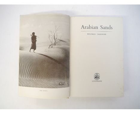
Wilfred Thesiger: 'Arabian Sands', London, Longmans, 1960, 2nd impression, signed by author to FFEP, folding map of the Empty Quarter in rear pocket, plus numerous other maps and photographic illustrations as called for, original cloth gilt. Thesiger's first and most important work, recounting his crossing of the Empty Quarter under the aegis of the Middle East Anti-Locust Unit in 1946-7. "Following worthily in the tradition of Burton, Lawrence, Philby and Thomas, [Arabian Sands] is, very likely, the book about Arabia to end all books about Arabia." Indeed, St John Philby described Thesiger as "probably the greatest of all explorers" (Maitland, 380) and Sir John Glubb regarded him "the last, and certainly one of the greatest, of the British travellers among the Arabs" (ibid.). Alexander Maitland, Wilfred Thesiger: the Life of the Great Explorer (2006). Provenance: signature obtained by vendor in person from Thesiger circa 2002 after corresponding with him by letter and subsequently visiting him at the nursing home in Surrey where he then resided as a very elderly man
Lot 7010
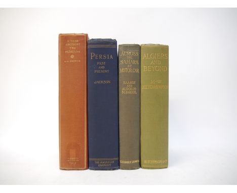
A.V. Williams Jackson: 'Persia Past and Present. A Book of Travel and Research', New York, Macmillan, 1906, 1st edition, large folding map of Persia & Afghanistan + 136 illustrated plates containing 220 photographic images as called for, original pictorial cloth gilt, top edge gilt. Jackson was an American Scholar and professor of Indo-Iranian languages at Columbia University, who was a great authority on ancient Persian history, language, and literature. Jackson travelled to Persia twice. The main purpose of his first trip in 1903 was to meet Zoroastrians living in Iran and study their customs and religion; together with Edward Granville Browne: 'A Year Amongst the Persians', C.U.P., 1926, 2nd edition, portrait frontis + folding map at end as called for, original cloth gilt; plus Hilton-Simpson: 'Algiers & Beyond', 1906, 1st edition, and Haardt & Audouin-Dubreuil: 'Across the Sahara by Motor Car', 1924, 1st edition, both with folding map and numerous illustrations from photos as called for, both original cloth gilt (4)

Lot 7011
(North Africa, The Maghreb, Travel), Budgett Meakin, 3 titles: 'The Moorish Empire - The Land of the Moors - The Moors', London, Swan Sonnenschein, 1899, 1901, 1902, 1st editions, 3 volumes, 1st volume, subscribers copy, signed by the author and numbered (12), numerous maps, plans, charts, plates & illustrations, uniform original pictorial cloth gilt, covers depicting fate of citadel, Tangier, vol 3 with Mudie's subscription lib label at head of top board. Scarce as a set; Alexander Graham & H.S. Ashbee: 'Travels in Tunisia', London, Dulau, 1887, 1st edition, folding map + 50 illustrations of which many full page plates as called for, original cloth gilt; Henri Basset: 'Essai sur la Litterature des Berberes', Alger, Jules Carbonel, 1920, 446pp, rebound quarter cloth gilt, original printed wraps bound in; Colonel Robin: 'Notes Historiques sur la Grande Kabylie de 1838 a 1851', Alger, Adolphe Jourdan, 1905, 269pp, orig. printed wraps (6)

Lot 7018
(Africa, Travel, Exploration), Lieut. Boyd Alexander: 'From the Niger to the Nile', London, Edward Arnold, 1907, 1st edition, 2 volumes, 3 large folding maps + portrait frontises and 48 plates as called for, ex Repton School Library, armorial bookplates and small number of inkstamps, original cloth gilt; Adolf Friedrich Duke of Meclenburg: 'From the Congo to the Niger and the Nile. An Account of the German Central African Expedition of 1910-1911', London, Duckworth, 1913, 1st edition, 2 volumes, folding map + numerous black & white plates as called for, ex Repton School Library, armorial bookplates and small number of inkstamps, original cloth gilt, top edges gilt; Colonel Sir W.F. Butler: 'The Campaign of the Cataracts. Being a Personal Narrative of the Great Nile Expedition of 1884-5', London, Sampson Low, 1887, 1st edition, 2 volumes, frontis, large folding map + black & white plates & ills. in text as called for, original pictorial cloth gilt (5)
Lot 7020
Count Joseph Potocki: 'Sport in Somaliland', London, Rowland Ward, 1900, 1st edition in English, limited edition (32/200), numbered and signed by Rowland Ward, "One of the rarest of all African big game hunting books", Czech (Africa) p.133, portrait colour frontis of author from a water-colour sketch by the distinguished Viennese studio of J. Löwy, photographer to the imperial and royal courts, plus 18 photogravures printed on india paper and mounted on light card leaves hinged with linen, 5 of them double page, as called for, lacking some tissue guards, and two tissue guards with child's scribbling, lacks large folding map at end, p.43/44 torn with large part loss affecting text/black & white ill. in text, numerous illustrations to the text, some full-page, most tinted, photogravure plates generally reasonably clean and ok, minimal foxing, but a small number with light tidemark to lower margin and some marginal soiling, one or two other leaves with marginal part loss/closed tears, small number of leaves loose, imperial 4to, original light tan pictorial buckram (bumped and worn/slightly grubby), title gilt to spine and front board, image of "Our Biggest Lion" in black to front board, embossed snakeskin effect endpapers, linen hinges, top edge gilt. A sumptuous work, this volume recounts the 1895 safari of Polish aristocrat and sportsman Potocki and his comrades to Somaliland's Haud region, then into Ogaden. The excellent artwork in the book is from the talented Polish illustrator Piotr Stachiewicz

Lot 7021
Henry Morton Stanley: 'Through the Dark Continent', London, Newnes, 1899, 2 volumes, large folding map + numerous maps, plates and ills. in text as called for, original pictorial cloth gilt, all edges gilt, bookplates of James Stafford Ransome (1860-1931), freelance journalist and author and founder of the British Engineers' Association (2)
Lot 7022
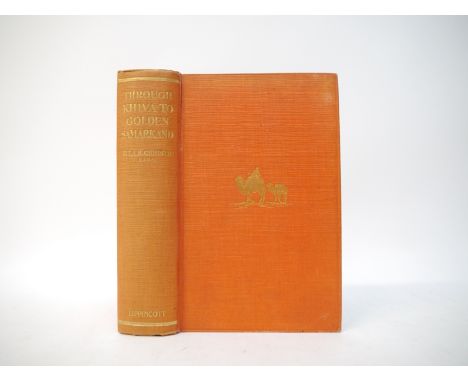
Ella Robertson Christie: 'Through Khiva to Golden Samarkand. The Remarkable Story of a Woman's Adventurous Journey Alone Through the Deserts of Central Asia to the Heart of Turkestan.', Philadelphia, Lipincott, 1925, 1st edition, map + 55 illustrations from photographs as called for, original cloth gilt. Scarce. Ella Christie (1861-1949) was a pioneering Scottish traveller and explorer who had an indominatoble adventurous streak and travelled extensivley throughout the world including Africa, the Middle East, Asia, the Far East and the Russian Empire including present day Central Asia. She was the first British woman to visit the Khanate of Khiva which had covered present-day western Uzbekistan, south-western Kazakhstan and much of Turkmenistan before the Russians arrived at the second half of the 19th century. She was amongst the first selection of women to be elected as fellows of The Royal Geographical Society in 1913, was a fellow of the Royal Geographical Society of Scotland, and in November 1934 she became a Vice-President of the society.

Lot 7025
Murray's Handbook of the Bombay Presidency. With an Account of Bombay City.', London, John Murray, 1881, 2nd edition, 4 folding maps as called for (including 1 in rear pocket at end) plus additional folding map of NW provinces Oudh & Rajput from Murray's Handbook of Bengal, couple of Repton School Library inkstamps, original cloth gilt; Jonquière: 'Histoire de L'Empire Ottoman', Paris, Hachette, 1881, 4 folding coloured maps at end, recased quarter cloth retaining large parts of original upper and lower wraps, spine title label (2)
![Shipping, Nippon Yusen Kaisha Line, oblong 4to souvenir book, circa 1920's/30's, [30]pp, mainly coloured plates including col](https://cdn.globalauctionplatform.com/090e9bfb-9918-4e0a-acb7-ae5200f80046/4e26009b-6273-41c8-b6b1-ae5900962b73/468x382.jpg)
Lot 7032
Shipping, Nippon Yusen Kaisha Line, oblong 4to souvenir book, circa 1920's/30's, [30]pp, mainly coloured plates including colour/chromo lithographs + large coloured lithograph folding cross section illustration of steamship (37x89cm) and folding coloured world map at end, printed Mitsuma Printing Works, oblong 4to, original red and white striped paper covered boards gilt, ribbon ties
Lot 7047
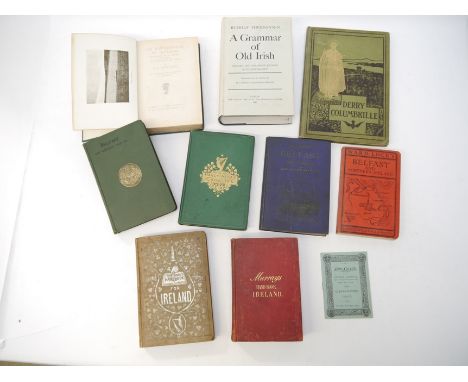
(Ireland), 'The Irish tourist's illustrated handbook for visitors to Ireland in 1852', London & Dublin, 1852, 3rd edition, 6 folding maps + engraved illustrations throughout, original decorative cloth silvered; R.A. Scott-James: 'An Englishman in Ireland. Impressions of a Journey in a Canoe by River, Lough and Canal', Dent, 1910, 9 black & white plates from photos + map as called for, orig. cloth gilt, top edge gilt; 'Murray's Handbook for Traveller's in Ireland', 1878, 4th edition, revised, 8 folding maps/plans, lacks railway map in rear pocket, original cloth gilt; J. Bartholomew: 'Philips' Handy Atlas of the Counties of Ireland', G. Philip & Son, 1882, 33 double page coloured maps as called for, original cloth gilt; [William Doherty]: Derry Columbkille. Souvenir of the centenary celebrations in honour of St. Columba, in the Long Tower Church, Derry, 1897-99', Dublin, [1899], [10],181pp, illustrations throughout, original pictorial cloth gilt; plus others Belfast; 'A Grammar of Old Irish', 1980; Sinn Fein 1905-06 16pp printed booklet (10)
Lot 7052A
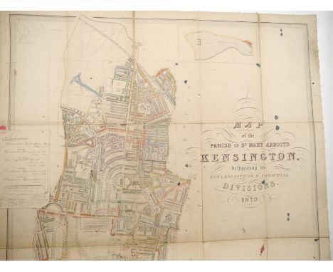
KENSINGTON - Edward DAW (publisher), 'Map of the Parish of St. Mary Abbotts, Kensington, delineating its Ecclesiastical & Parochial Divisions 1879', London, Edward Daw, 1879. Large folding hand coloured engraved map extending from the Portobello Road in the north to the Fulham Road in the south, mounted on linen, approximately 108 x 76cm, with some old manuscript annotations and two old relevant manuscript notes attached at margin, worn at folds/corners, couple of inkspots, folding into original green cloth wallet (worn) lettered in gilt. A rare and detailed plan of Kensington produced during a period of great westward expansion in Victorian London

Lot 7054
A collection of volumes relating to London and environs, including 'County of London Plan', Macmillan, 1943, numerous plates, folding maps/plans etc, 'Greater London Plan 1944', HMSO, 1945, profusely illustrated with folding maps, plans and plates, each large 4to, original cloth gilt; Samuel Woodburn: 'Ecclesiastical topography : a collection of one hundred views of churches in the environs on London', Cadell & Davies, 1807-1811, 2 volumes in 1, 2 engraved title pages + 100 engraved plates as called for, 4to, contemporary full decorative calf gilt (very worn); 'The Post Office London Directory 1965', Kelly's, 1965, thick 4to, orig. cloth gilt; T.R. Way: 'Suburban Reliques North of the Thames', 1898, limited edition (59/280, signed and numbered, 24 lithograph plates as called for, 4to, orig. quarter vellum worn; 'Catalogue of the Tombs of London AD 1666', London, Privately Reprinted, 1885, orig. wraps; London Topographical Society 3 volumes, 1960's map volumes facsimiles famous London maps/views; 3 Tape Indicator folding maps London circa 1900, etc (25)
Lot 7056
A large collection of volumes relating to London and environs, including 'The Endowed Charities of the City of London', M. Sherwood, 1829, old hald calf gilt; Robins 'Paddington Past & Present', [1853], original cloth gilt; Thomas Boyles Murray: 'Chronicle's of a City Church Being an Account of the Parish Church of St Dunstan in the East', Smith Elder, 1860, extra illustrated/grangerized copy, with additional engraved folding map 1754 and other 18th & 19th Century engraved folding views, plates, relevant cuttings etc etc, original cloth gilt; 'The New Picture of London, being a Complete Guide and Hand-book', John Reynolds, [1839], engraved frontis and plates, original cloth gilt; early 20th Century photo album of Hill Hall, Epping, with blueprint plan loosely inserted; 'The London Directory of 1677', 1878 facsimile edition; Hutton: 'Literary Landmarks of London', 1888; 'Dicken's Dictionary of London 1879'; plus others Chiswick, Brentford, Ebury, Westminster, Walbrook, Belgravia, 'Liber Albus The White Book of the City of London, 1861'; Wallis's New Plan of London, c.1831, engraved hand coloured folding map, backed onto linen, 42 x 67cm, in original paper covered sleeve, printed paper label; 6 folding tape indicator maps of London circa 1900, etc (50+)
Lot 7059
Topography, including Murray's Handbooks for Travellers Greece, 1872, 4th edn revised, 12 maps/plates/plans, mostly folding, and Syria & Palestine, 1875, new edition, numerous maps & ills including 2 folding in pockets at front and end, each org. cloth gilt; Baedeker's Guides Spain & Portugal, Northern France, Northern Italy; Ball's Alpine Guides 'Central Tyrol', 1873, folding panorama + 2 folding maps, 'Western Alps', 1863, folding panorama + 5 maps (lacks frontis map), 'Central Alps', 1866, lacks some maps, each org. cloth gilt (slightly soiled); 'Batholomew's Road Map of Scotland', circa early 1900's, seven folding coloured sheets backed onto linen, quarter inch to a mile, pub Sifton Praed & Co, in original leather case (dilapidated); John Rutter: 'Delineations of The North Western Division of the County of Somerset', London, 1829, with the 20 additional engraved plates, 4to, contemporary half leather gilt (worn); plus another similar volume on Manchester with engraved plates, 1830, plus 1 other

Lot 7062
(Topography, Oxford & Cambridge etc) Thomas Wright (of Trinity College Cambridge) & William Bartlett: 'The History & Topography of the County of Essex', 1836, 2 volumes, added engraved vignette title pages, engraved folding map, 100 engraved topographical and architectural views including country houses etc, bindings a/f very worn; Willis & Clark: 'The Architectural History of the University of Cambridge, and of the Colleges of Cambridge and Eton', Cambridge, 1886, 3 volumes, engraved plates & ills. in text, uniform full crushed green morocco, gilt tooling, "T.H.F." monogram in gilt to front covers, spines a bit faded and slightly rubbed and worn, but a nice quality signed binding "Bound by Stoakley. Late Hawes", marbled EP's/pastedowns, all edges gilt; 'An Inventory of the Historical Monuments of the City of Cambridge', 1959, 2 volumes, 4to, orig. decorative cloth gilt, dust wrappers, plus map/plans volume, with ditto Oxford, 1949 2nd printing, orig. cloth gilt, dust wrapper (9)
Lot 7065
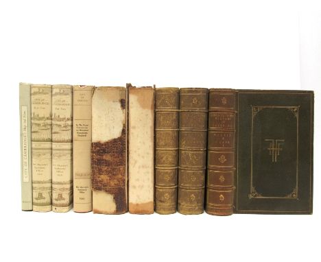
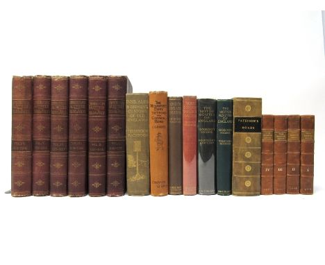
Collection topography, including Edward Mogg: 'Paterson's Roads; Being an Entirely Original and Accurate Description of all the Direct and Principal Cross Roads in England and Wales, with Part of the Roads of Scotland. &c', 1826 [but later, ads dated Jan. 1837], 18th edition, large engraved folding map of England & Wales (dated 1826), plus 11 engraved maps on 8 folding plates as called for, old quarter calf gilt, recased; Daniel Defoe: 'A Tour Through the Island of Great Britain. Divided into circuits or journies. interspersed with useful observations. Particularly fitted for the perusal of such as desire to travel over the Island', London, W. Strahan et al, 1778, 8th edition, 4 volumes, 2 folding engraved maps as called for, contemporary calf, later rebacked; with J. Brabner: 'The Comprehensive Gazetteer of England and Wales', William Mackenzie, circa 1895, 68 double page maps + 24 steel engraved plates, large 8vo, uniform original publisher's cloth gilt, all edges gilt; plus 6 others Inns & Taverns, coaching roads, motoring, including Hackwood: 'Inns, Ales & Drinking Customs of Old England', 1909, 1st edition, plates, original cloth gilt, Harper: 'The Newmarket, Bury, Thetford, and Cromer Road. Sport and History on an East Anglian Turnpike', 1904, 1st edition, original cloth, etc (17)

Lot 7067
Solar eclipse. Cave (E. & Smith G.), 'The Geography of the Great Solar Eclipse of July 14 MDCCXLVIII Exhibiting an Accurate Map of all parts of the Earth in which it will be visible with the North Pole....', published `The Gentleman`s Magazine`, 1748, engraved map with twenty-four diagrams of the extent of the eclipse in various locations, framed and glazed, the whole approx size 50 x 61cm


Lot 7071
(Staffordshire) John Speed: 'Stafford Countie and Towne with the ancient Citie Lichfeild described', engraved hand coloured map, circa 1627, John Sudbury & George Humble, inset town plans of Stafford and Lichfield, framed and double glazed, the whole approx size 45 x 56cm, English text verso

![John Speed: 'Flintshire', hand coloured engraved map, published Thomas Bassett & Richard Chiswell, [1676], inset town vie](https://cdn.globalauctionplatform.com/090e9bfb-9918-4e0a-acb7-ae5200f80046/62fd6a97-a7e9-4946-8155-ae59009667d7/468x382.jpg)
Lot 7080
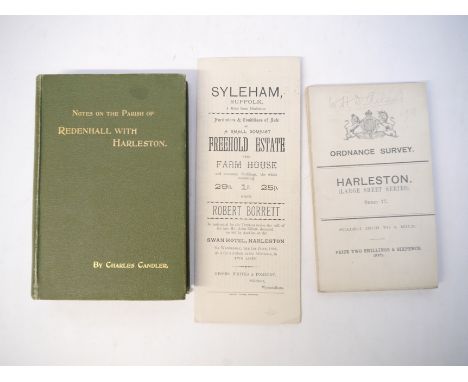
Harleston - 'Notes on the Parish of Redenhall with Harleston', by Charles Candler, 1896, 1st edition, Loosely inserted a letter of 1894 asking about the acreage of Harleston and an early 20th Century photographic postcard of Candlers, Harleston. Together with an Ordnance Survey map of Harleston, 1909 and sale particulars of a freehold estate to be sold by Robert Borrett, Harleston, 1892.

Lot 7082
Armstrong 'History & Antiquities of the County of Norfolk', 1781, 4 odd volumes, including vol. V Freebridge Lynn, Freebridge Marshland, and Gallow, engraved folding map of the Fens + 7 engraved plates, comprising Castle-Acre Castle; Castle-Acre Monastery; Rising Castle; Lynn Regis (King's Lynn); Middleton Castle; portrait Robert Walpole; Houghton Hall; Volume VII Happing, Henstead, Holt, Humbleyard & Loddon, 7 engraved plates, comprising Hickling Priory; Bixley Hall; Venta Icenorum; Kirby Bedon Hall; Melton Constable Hall; Ditchingham Hall; Langley House; Volume IV West Flegg, East Flegg & Forehoe, 4 engraved plates comprising Caister Castle; Great Yarmouth prospect; Easton Lodge; Wymondham Abbey; each old half calf gilt (worn); part copy of Volume 3, South Erpingham, 5 engraved plates comprising Blickling Hall; Heydon Hall (engraved by William Ellis from a drawing by Humphrey Repton); Irmingland Hall (engraved by J. Page from a drawing by Humphrey Repton); Wolterton Hall; Wood Dalling Hall (engraved by J. Page from a drawing by Humphrey Repton), a/f, disbound, lacking leaves at beginning (4)
![[Mostyn John Armstrong]: 'History and Antiquities of the County of Norfolk. Volume I. Containing...The Hundreds of Blofield,](https://cdn.globalauctionplatform.com/090e9bfb-9918-4e0a-acb7-ae5200f80046/c22b411c-177f-468a-9750-ae5900967509/468x382.jpg)
Lot 7084
[Mostyn John Armstrong]: 'History and Antiquities of the County of Norfolk. Volume I. Containing...The Hundreds of Blofield, Brothercross and Clackclose', Norwich, 1781, folding engraved map of Norfolk frontis, 204,26,295pp, contemporary calf, later handsomely rebacked brown calf with gilt bands and gilt leather title label

Lot 7086
Francis Blomefield: 'An Essay Towards a Topographical History of the County of Norfolk', London, William Miller, 1805-1810, 11 volumes, mezzotint portrait frontis plus 3 folding engraved maps/plans (Norwich, King's Lynn, and Map of Marshland that is often lacking) plus 33 engraved plates (many folding) plus 14 pedigrees on 15 folding sheets as called for, half titles, uniform old cloth gilt, leather gilt title labels to spines. Clean and tidy set of Blomefield's comprehensive history of the county of Norfolk, widely considered to be detailed, reliable and comparable with the best county histories of the period; together with a well illustrated biography of Francis Blomefield, Norfolk's greatest antiquarian, by Stephen Govier, 2011, signed by the author (12)
Lot 7095
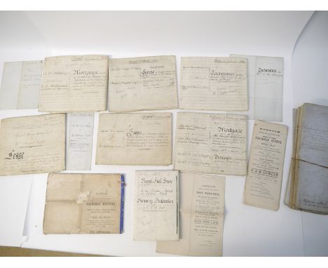
Collection of 19th vellum and other documents relating to Burgh Hall, Burgh Hall Farm & Estate, Burgh Next Aylsham, Norfolk, James Hunt Holley Esquire, son of Aylsham Attorney George Hunt Holley, 7 vellum and 4 paper documents 1860-1869 including leases, conveyance, mortgages, sale particulars etc, 1863 vellum conveyance of the Burgh Hall Estate with large manuscript pen, ink & wash plan; 1863 Burgh Hall Estate Statutary Declaration with a good quality large folding pen, ink & wash plan; 1873 lease of Burgh Hall with smaller pen & ink map, etc; plus 11 Abstracts of the Title of James Hunt Holley Esqre to a Capital Mansion House called Burgh Hall and land situate at Burgh next Aylsham, 1861/62. The once grand Jacobean style mansion of Burgh Hall was demolished in 1981. The hall was originally owned by the Holley family and rebuilt in the 1830s with architectural plans showing extensions for a new veranda by James Hunt Holley, son of Aylsham attorney George Hunt Holley. These were designed by George Stanley Repton, the fourth son of the famous landscape designer, Humphry Repton, who created Sheringham Park. The land at Old Hall Farm, the site of the former mansion, was sold by Savills in October last year for £2.2m

Lot 7131
(Diss, Yaxley, Brome Hall, Roydon etc) packet sale particulars including 'Valuable Commercial Premises, Market Place, Diss, formerly the Star Inn & Old Corn Hall', 1950 sale particulars, folding map, original printed wraps, TW Gaze auctioneers, plus 4 others Diss including Market Hill 1898, 1931 & 1936, 5 sale posters late 19th & 20th Century including Diss, 12 sale particulars Yaxley 1940's; 'The Brome Hall Estate, Suffolk', sale catalogue 1953, 406 acres, relating to the estates of Sir Thomas Henry Tacon and Miss Maude Tacon, [32]pp, 2 folding coloured plans in rear pocket, comprising 30 individual lots Brome Hall, Home Farm Brome, Eye Railway Yards, The Red House Eye, Bridge House Eye, Bush Farm Denham and Cottages in Hoxne, TW Gaze Auctioneers, original printed wraps. Formerly the seat of the Cornwallis family, purchased by Sir Edward Kerrison's family and inherited by Lady Agnes (Kerrison) Bateman of Shobdon, Herefordshire. Purchased byu Sir Thomas Henry Tacon of Eye and inherited by his daughter Maud Tacon (d.1953) who was engaged to the Rev. Polycarp Oakey who pre-deceased her; George Poulter: 'The Corbould Genealogy', 1935, reference to Syleham & Hoxne, coats of arms and portrait illustrations; a Parish profile for Roydon compiled from local records
Lot 7133
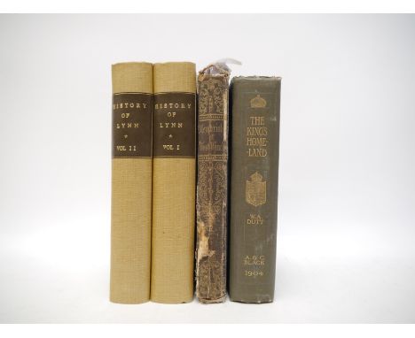
William Richards: 'The History of Lynn', King's Lynn, Baldwin, 1812, 2 volumes, a/f lacks plates/map, rebound quarter cloth, marbled paper covered boards, bookplates of John Blatchly; Rev. George Eller: 'Memorials of West Winch', 1861, signed and inscribed by author verso frontis, working copy, worn a/f, lacks map, all other litho plates by RS Groom Wilkinson present, original cloth gilt (worn); W.A. Dutt: 'The King's Homeland Sandringham and North-West Norfolk', 1904, introduction by Henry Rider Haggard, original cloth gilt (4)

Lot 7138
Six linen-backed 19th Century folding sheet maps for Suffolk, Essex & Norfolk, including 1805 hand coloured in outline sheet depicting area from Rotherhithe East London to River Medway/Thames Estuary and Waltham Abbey to Maldon, 65 x 95cm; 1890 sheet 207 depicting Ipswich and surrounding area, 42 x 57cm; 1889 sheet 208 Woodbridge and environs, etc; plus a detailed facsimile large folding OS sheet map of Orford, 1927 (7)


Lot 7173
Committee of Inquiry on Grouse Disease and A. S. Leslie: 'The Grouse in Health and in Disease: Being the Final Report of the Committee of Inquiry on Grouse Disease', London, Smith, Elder, 1911, 1st edition, 2 volumes, 58 full page plates, of which many in colour + 41 maps, full page colour map of mean rainfall for 25 years in Scotland, as called for, xxiii,512pp; vii,150pp, 4to, uniform original publisher's cloth gilt, top edges gilt, armorial bookplates of Colonel Edward Donald Malcolm, 16th Laird of Portalloch (1837-1930), to front pastedowns. The beginning of the modern West Highland White Terrier breed is attributed to Colonel Malcolm of Poltalloch, Scotland in Argyllshire in the late 1800's (2)
Lot 7176
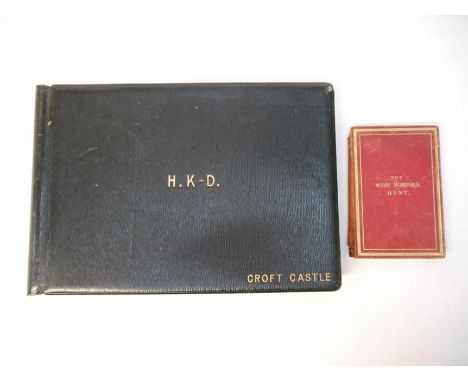
A game log book with 40+ pages of manuscript entries dating from the 1930s and onwards, several shoots being in Norfolk and Suffolk, the large oblong leather album dating from slightly earlier, probably circa 1900, monogrammed in gilt to front cover "H. K-D. Croft Castle", from 1799 Croft Castle in Herefordshire became home to the Kevill-Davies family, and after 1847 was inherited by William Albert Somerset Herbert Kevill-Davies who served in the South African war. In 1908 he married Dorothy Mortlock Lacon, heiress to the Lacon brewery in Great Yarmouth. Entries for shoots at Gunthorpe Hall, Norfolk; Croft Castle; Ormesby, Norfolk, various houses including Ormesby Hall, many names listed including R. Dashwood, Colonel Benn, Capt. Thatcher, Sir J Benn, Sir G. Talbot, Major Miller, Sir G. Lacon, Sir A. Haylerigg, B. Nightingale, Sir J. Rawlinson etc; Maultby, Norfolk; entries in a couple of different hands and dating upto 1980s, other locations include Isle of South Uist Outer Hebrides, more Ormesby Hall including J. Lacon, Dick Rayner etc etc, m/s entries comprise 26 pages of log entries + 16 pages with additional remarks on blank facing page, boards approx 26x39cm, old full leather gilt, inner dentelles gilt, all edges gilt; together with a late 19th Century engraved folding map of West Norfolk, folding into red calf gilt binding titled in gilt "The West Norfolk Hunt" to cover (2)


-
109198 item(s)/page