We found 109182 price guide item(s) matching your search

Refine your search

Year

Filter by Price Range
  • List
  • Grid
  • 109182 item(s)
    /page

Lot 3514

Local Interest - Herman Moll (1654 - 1732), by and after, a map, Derby Shire (sic, Derbyshire), inset named-views of Pooles Hole (sic) and The Devils Arse (sic) to margin, with fossils and geological specimens from the county explained, from A Set of Fifty New and Correct Maps of England and Wales, [London 1724], hand-coloured engraving, 32cm x 19cm; William Bernard Cooke (1778 - 1855), after Sir Francis Leggatt Chantrey RA (1781 - 1841), Smelting House, in Middleton Dale, Derbyshire, [London 1818], engraving, 21cm x 18cm, [2]

Lot 3511

Joan Blaeu (1596 - 1673), by and after, a two-page map, Darbiensis Comitatvs, Vernacul Darbie Shire (sic, Derbyshire), proto-Baroque cartouche and allegory to lower-left margin, two pages of Latin topographical text to verso, pages 261 - 262, from volume IV of Theatrum Orbis Terrarum, 1645, copperplate engraving, fine 17th century hand-colouring to recto, 54.5cm x 64cm

Lot 3512

John Speed (1551/52 - 1629), by and after, two-fold map, The Kingdome (sic) of China, newly augmented by J.S., 1626, Are to be fold (sic) by Tho: Bafsett (sic) in Fleet Street, and Ric: Chifwell (sic) in St. Pauls (sic) Church yard, [London], hand-coloured engraving, 40cm x 52.5cm

Lot 3508

Astronomy and Cartography - Johann Gabriel Doppelmayr (1677 - 1750), by and after, astronomical chart, Ephemerides Motuum Coelestium Geometricae, from Atlas Coelestis, Published by Johann Homann, Nuremberg [1742], engraving, hand-coloured delineations and vignettes, 51cm x 61cm John Thomson (1777 - c. 1840), by and after, a two-fold map, Spanish North America: Southern Part, No. 59, Drawn & Engraved for Thomson's New General Atlas, [probably London] 1816, hand-coloured engraving, 55cm x 73cm; Johann Christoph Harenberg (1696 - 1774), after, a two-fold map, Imperii Turcici Europaei Terra, in primis Graecia [Greece], [Published by Homman's Erben, Nürnberg] 1741, title vignette framed by an arrangement of Ancient Greek coins, engraving, delineated with hand-colouring, 51.5cm x 62cm; Johann Matthias Hase (1684 - 1742), after, a two-page map, Hungariae [Hungary, with bordering states and countries], [Published by Homman's Erben, Nürnberg] 1744], line engraving, with hand-coloured delineations, fanciful cartouches and vignettes, 52cm x 61cm (4)

Lot 3600

Local Interest - Pilkington (James) A View of the Present State of Derbyshire; with an Account of its Most Remarkable Antiquities; Illustrated by an Accurate Map and Plates, two-volume set, Printed and fold (sic) by J. Drewry, London 1789, pp: volume I, viii, 496, title-page with ten-fold fold-out engraved map of the county; volume II, iv, 464, title-page with fold-out engraved antiquarian plate, slightly later quarter-calf and marbled boards (disbound), 8vo, (2); Provincial Imprint, Davies (The Rev. D.P.), A New Historical and Descriptive View of Derbyshire, from the Remotest Period to the Present Time, Printed and Published by and for S. Mason, Belper 1811, pp: viii, [ii], 717, [xiv], six-fold fold-out hand-coloured engraved county map to title-page, contemporary marbled calf, gilt lettered red morocco title label to spine, recto pastedown with tipped-in clipped autograph of the author, 8vo; Britton (John) & Brayley (Edward Wedlake), The Beauties of England and Wales; or, Delineations, Topographical, Historical, and Descriptive, of Each County, Embellished with Engravings, volume III only: Cumberland, Isle of Man and Derbyshire, Printed by Thomas Maiden [...], London 1802, contemporary half-calf and marbled boards, 8vo, [4]

Lot 3594

Local Interest - Mawe (John), The Mineralogy of Derbyshire: with a Description of the Most Interesting Mines in the North of England, in Scotland, and in Wales; and an Analysis of Mr. William's Work, Intitled (sic) "The Mineral Kingdom", Subjoined is A Gloffary (sic) of the Terms and Phrafes (sic) ufed (sic) by Miners in Derbyshire, first and only edition, Printed and Sold by William Phillips, London 1802, pp: xv, 211, illustrated with one full-page engraved map and three-full page engraved geological plates, later buckram boards, 8vo

Lot 3509

Coghlan's New of Map of London and Its Suburbs, with the Improvements to 1836, Published by H. Hughes, 15, St. Martin-le-Grand, ten-fold, hand-coloured engravings laid on canvas, 26.5cm x 41.5cm, contemporary blue card sleave applied with publisher's paper label; Railway Map of the Environs of London: Showing the Route of all the Lines of Railway Now Open, and in Progress, from the Metropolis to the Extent of Thirty Miles from the Post Office [...], Published by J.R. Robbins, 3, Warwick Court, Holborn and R. Tyas, 8, Paternoster Row, London 1840, steel engraving with some hand-coloured delineations, paper laid on canvas, fifteen-fold, 35.5cm x 48cm, contemporary cloth covers (upper detached); C. Graf (second-quarter, 19th century), by, The Circuiteer: A Series of Distance Maps, to serve as a guide for ascertaining Cab Fares, Porterage, &c., & c., No. 1: London, Published by J. Friedericks, 5, Nassau Street, Soho, London 1850, chromolithograph, forty-five fold, 55cm x 71.5cm, the fold prefixed by explanation and index - 8pp, contemporary black buckram wrap, applied with publisher's paper label; Stanford's Library Map of London and Its Suburbs, Sheet 14, Published by Edward Stanford, 55 Charing Cross, London 1877, hand-coloured engraving on card, laid on canvas, twenty-five fold, 65.5cm x 55.5cm, contemporary blue buckram covers as issued with publisher's paper label, marbled endpapers; Panorama of Hastings, Published by Rock & Co., London [n.d., c. 1840], ten fold-out engraved views and vignettes, within lithographic borders of foliage, each 9cm x 12cm, yellow endpapers, contemporary bookseller's ticket: W. Reid, Stationer, Print & Music Seller, Pelham Library, Hastings, contemporary buckram, gilt lettered upper cover within a blind tooled cartouche, [5]

Lot 3647

Topography - Robinson (William, Gent., F.S.A.), The History and Antiquities of the Parish of Edmonton, in the County of Middlesex; comprising an Account of the Manors, the Church, and Southgate Chapel, with other Interesting Matter [...], first and presumably only edition, Printed for the Author [...], London 1819, pp: xiii, [i], 331, thirteen engravings as called for: title-page with fold-out thirty-fold [...] Map of the Parish [...] Shewing (sic) the Allotments in the Common Fields & Common Marshes as divided by Act of Parliament in the Years 1801 & 1802, engraving with contemporary hand-coloured cartographic delineations, 53cm x 73cm, further Plan of the Orsett Estate, and further topographical and antiquarian studies and reproduced portraits, contemporary Regency calf gilt lettered and tooled spine with plain calf boards, the upper board with ironic MS label: Keep in the Family, repeated to top margin of recto endpaper, inscribed in pencil Baron Platt with additional tipped-in ink MS letter from Newnham Lodge, Hook, Hans, indistinctly signed and dated 1942, citing the book was the his grandfather's Sir Thomas Joshua Platt [KC], "most commonly known as Baron Platt", [1788/90 - 1862, British judge who served as Baron of the Exchequer], 8vo

Lot 3583

Local Interest - Derby, Lord Belper's Copy, Hutton (W[illiam]), The History of Derby; From the Remote Ages of Antiquity, to the Year MDCCXCI [...],Printed by J. Nichols [...], London 1791, pp: xiii, [ii], 32, illustrated with full-page engraved plates, fold-out map and fold-out panorama of the city, Regency calf gilt, panelled blind with a frieze of acanthus in a gilt border of scrolling acanthus, later calf lettered spine, repairs to corners and reinforced text block, marbled edges, marbled endpapers en suite, Plain Armorial crested bookplate to recto pastedown: Belper, surmounted by crest and baron's coronet, 8vo; Simpson (Robert), A Collection of Fragments Illustrative of the History and Antiquities of Derby, Compiled from Authentic Sources, Illustrated with many Engravings, Printed and Sold by G. Wilkins and Son, Derby 1826, pp: [vi], 876, late 20th century green quarter-morocco gilt and marbled paper board, 8vo, [2] Provenance: Hutton's Derby ~ Edward Strutt, 1st Baron Belper PC FRS (1801 - 1880); sold Christie's, Printed Books: The Property of the Lord Belper, December 15th 1976, Lot 99 - part lot (1 of 3), £140.

Lot 3649

Travel/Exploration - Signed & Dedicated Copy, Campbell (W.W.), East Africa by Motor Lorry: Recollection of an Ex Motor Transport Driver, first and only edition, with Photographs, Sketches, and a Map by the Author, John Murray, London 1928, pp: xii, 318, adverts [iv], recto endpaper autographed and inscribed by the author in ink MS: To my friend Mr "Dick" Ba*in with best wishes from the Author "Will" Campbell [...] Nottingham, original blue cloth gilt as issued, 8vo

Lot 3510

Edward Weller, by and after, Bacon's Popular Map of England and Wales, published by G W Bacon & Co, London, 85cm x 66cm

Lot 3588

Local Interest - Farey (John, Sen.), General View of the Agriculture and Minerals of Derbyshire; with Observations on the Means of their Improvement, Drawn up for the Consideration of the Board of Agriculture and Internal Improvement, three-volume set, Printed by B. M'Millan [...] For Sherwood, Neely & Jones [...], London 1811 - 1817, pp: volume I, xlvii, [i], 532, [ii], [ii], illustrated with five hand-coloured engraved maps and sections of strata; volume II, [iv], 522, [iii], [ii], illustrated with four engraved plates; volume III, xxvii, 725, [ii], illustrated with two full-page engraved plates and one fold-out map, 20th century brown buckram with lettered spines, by David Billet, tickets to verso pastedown, 8vo, [3]

Lot 3513

John Speed (1551/52 - 1629), by, two-fold map, Cumberland and the Ancient Citie Carlile (sic, Carlisle) Described with Many Memorable Antiquities Therein Found Observed, English text to verso, [Sold] in Popes-head (sic) Alley, by the exchange by I. Sudbury and Georg. Humble, [London] 1610, engraving with contemporaneous hand-colouring, 40cm x 53cm

Lot 3590

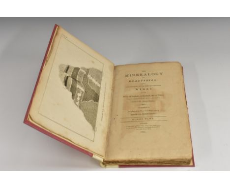
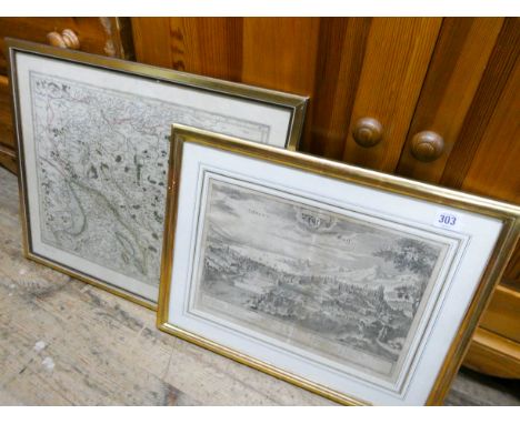
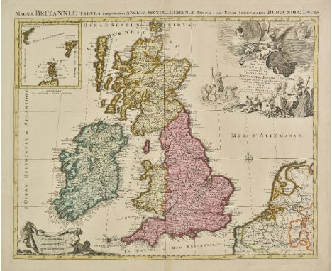
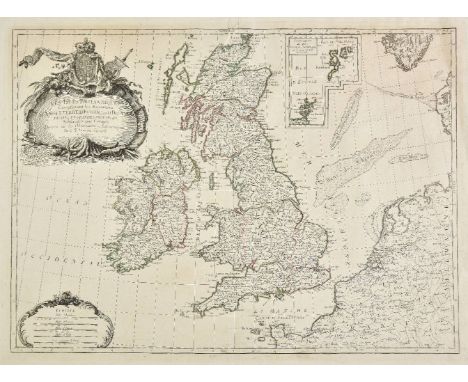
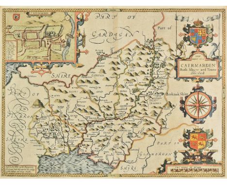
Local Interest - Guides - Provincial Imprints: [Moore (Henry)], Picturesque Excursions from Derby to Matlock Bath, and its Vicinity; Being a Descriptive Guide to the Most Interesting Scenery and Curiosities in that Romantic District, with Observations Thereon, Illustrated with Twelve Etchings [...], Published by H. Moore, Derby 1818, pp: 107, [i], publisher's boards, 12mo; Moore (Henry), Picturesque Excursions in the High Peak of Derbyshire: [...] Buxton and Castleton Guide [...], A New Theory to account for the Ebbing and Flowing Well, Situated in Barmoor Clough, near Buxton [...], Embellished with Nine Plates, Published by H. Moore, Derby 1819, pp: 119, [i], publisher's boards, 20th century buckram spine, contemporary ink MS ownership to upper cover: Miss Bodenham, who has inscribed a MS list of 'Views in this volume' to recto pastedown, 12mo; [Simpson (Robert)], A Walk through Derby, containing a Concise Account of the Public Buildings, in the Town; Compiled from Authentic Sources, Printed and published by and for G. Wilkins & Son, Derby 1827, pp: 120, topographical views within text throughout, pictorial publisher's boards, 12mo; Moore (Henry), The Romantic Beauties of Dove-Dale and Ilam [...], With Plates, Printed and Sold by W. Hoon, Ashbourn (sic, Ashbourne) 1829, pp: 70, [ii], publisher's pink boards, 16mo; The Journey-Book of England: Derbyshire, with Twenty-Three Engravings on Wood, and an Illuminated Map of the County, Charles Knight & Co., London 1861, contemporary calf spine and marbled boards, 16mo; Buxton: [Orme (Daniel)], The Buxton Guide, and Excursive Companion [...] of the High Peak, with Engraved Illustrations [...], Published for the Author [...], Buxton 1842, contemporary boards, later calf spine, 16mo; others, The Rambler's Guide to Buxton [...], publisher's boards, 12mo, Breadsall Priory Copy: Buxton and Its Resources, [n.d., 1863], Plain Armorial bookplate to recto pastedown: Alfred Seale Haslam, 12mo & Views in Buxton and Neighbourhood, Published by J.C. Bates, 1865 - 1867, 45 steel engraved views, oblong 12mo; Thomas (John), Walks in the Neighbourhood of Sheffield, Yorkshire, Printed by Robert Leader, Sheffield 1830 - 1831, 12mo

Lot 3628

Ogilby (John) and Bowen (Emmanuel), Britannia Depicta (sic): or, Ogilby Improv'd; Being a Correct Coppy (sic) of Mr: Ogilby's Actual Survey of all ye Direct & Principal Crofs (sic) Roads in England And Wales [...] 1, A full & particular Defcription (sic) & Account of all the Cities, Borough-Towns, Towns-Corporate & their Arms [...] with fuitable (sic) Remarks on all places of Note drawn from the beft (sic) Historians and Antiquaries [...], 2, The Arms of the Peers of this Realm who derive their Titles from places lying on, or near the Roads, 3, The Arms of all ye Bishopricks (sic) and Deaneries, their foundation, Extent, Yearly-Value, Number of Parifhes (sic) [...], 4, The Arms, & a fuccint (sic) Account of both Universities & their refpective (sic) Colleges, their foundations, Fellowfhips (sic) [...], fourth edition, Printed & Sold by Tho: Bowles, Print & Map Seller, [London n.d. 1736], pp: engraved allegorical title-page, tables [viii], 273 engraved full-page road and county maps as called for, relaid contemporary calf boards blind, with early 19th century calf spine gilt with lettered red morocco title-label, small 8vo

Lot 3575

Local Interest - A Compleat (sic) History of Derbyshire [...], Printed by E. and R. Nutt [...] In the Savoy, 1730, pp: [i], three-fold map of the county by Robert Morden (c. 1650 - 1703), 423 - 463, distance table [1], 20th century black morocco spine and title label gilt to upper cover, maroon buckram boards, 8vo; [Nightingale (Joseph)], Derbyshire, [Baldwin, Cradock and Joy, London 1816], pp: lacking any prelims, [4], 2 full-page engraved maps of the city and its eponymous county by John Roper after George Cole, 20th century brown faux 'morocco' buckram, gilt lettered black leather title label to upper-cover, 4to, [2]

Lot 572

JOHN SPEED, DOUBLE SIDED MAP OF NOTTINGHAMSHIRE, HAND COLOURED ENGRAVING, C1627, 39 X 51CM

Lot 221

Military items relating to Captain Harvey Weiner to include cloth and brass badges, buttons, a map, printed ephemera, whistles, a WWII Austrian blanket and a medal

Lot 463

After Robert Morden. Map of Cumberland, picked out in colours, with Swale and Churchill stamp, 18thC, 41cm x 46cm.

Lot 443

Various ephemera, maps, etc., to include map of Yorkshire, various others, etc. (a quantity)

Lot 106

H. MOLL MAP OF STAFFORDSHIRE WITH ANTIQUITIES together with various other Staffordshire county maps including Aikin 1798, John Seller, Phillips, 19th Century town plan of Stafford, Walker town plan of Birmingham (all loose, not mounted or framed) together with an 18th Century engraving of 'The Gate of the Manor House of Tixall, Staffordshire and a 19th Century engraving of 'The Talbot Arms Inn, Rugeley, Staffordshire (9)

Lot 404

LONDON & THAMES INTEREST BOOKS AND EPHEMERA to include various 19th and 20th Century works together with a 1762 publication of a parliamentary 'act to prevent the committing of thefts and frauds by persons navigating Bum Boats, and other boats upon the River Thames' and a folding 'Map of West Ham' 4 inches to a mile published by Wilson & Whitworth, Broadway, Stratford 1899 A/F

Lot 603

225th Parachute Field Ambulance D-Day 6th June “Top Secret” Landing Maps, Photograph Archive. Pegasus Bridge Interest.This is the archive of Douglas Protheroe a medic with the 225th Parachute Field Ambulance unit which on the night of the 6th June dropped in the vicinity of Pegasus Bridge and he then served in the Advance Dressing Station in the Café Gondrée at the bridge. Comprising: Map “Defences Troarn” classified as Top Secret until issued then secret. This shows detail of the area, bridge lengths, flood areas etc. ... Aerial Photograph, possibly of Drop Zone. ... Issue Map 7F/2 1:80,000 (1943) Sheet including the reference area of the drop zone and Pegasus Bridge. ... Map 7 F/1 Caen. ... Map Sheet 153 NW (May 1944) 1:25,000 Bonnebosq. Map Sheet 7F 1:100.000. ... Military Issue Map Case. ... Original printed Journal of the 225 Para Field Amb Normandy Edition (July 1944). ... An number of original editions of “Pegasus Goes To It” including 1 to 6 (June 1944) (10 total). Large fragment of silk parachute stamped “National Automotive Fibres Inc Dec 18 1943”. ... Far East Silk Map. ... etc. A digital image of Douglas Protheroe is also available.Mr Douglas Protheroe enlisted into the Army as a conscientious objector, transferred to the RAMC, he like many of his fellow thinkers wanted to do his part and volunteered for the dangerous duties with the Parachute Field Ambulance with the 6th Airborne Division, 5th Parachute Brigade, 225th (Parachute) Field Ambulance, which had formed at Castle Cary on 7th June 1943. It was in this capacity in the early hours of the 6th June his aircraft lifted into the night sky, to be one of the first units to land in France. His aircraft was unable to find the drop zone at 01.05 hrs and the pilot went around again locating the Zone the unit dropped at 01.20 hrs, their RV being a copse shown on map 7 F/2. near Bénouville Bridge for ever now known as Pegasus Bridge. He was selected and help set up medical aid post at Café Gondrée with Lieutenant-Colonel Bruce Harvey. The unit served in France for 77 days before shipping back to the UK. Douglas Protheroe remained with the unit and saw action in the Ardennes during the winter of 1944 and then took part in Operation Varsity the “Rhine Crossing”. Following VE day the unit prepared for the Far East. He remained with the Army until 1951. The biographical information is supplied by the vendor.

Lot 755

German Third Reich WW2 Army / Waffen SS issue Krim arm shield.A good bronzed example. Eagle and swastika on shield bearing the dates 1941 1942 and map of the Crimea; the reverse retains all four securing blades. Minor service wear. GCKrim instituted 25th July 1942

Lot 756

German Third Reich WW2 Army and Waffen SS Kuban Arm shield.A good dull brass example on field grey cloth. Eagle and swastika on shield bearing the date 1943 and map of the region. Retains original metal backing plate, backing paper and all four pairs to blades. Removed from uniform. Generally VGC.Instituted 20th September 1943, for the defence of the Kuban Bridgehead on the Eastern Front.

Lot 303

A framed black and white print and a framed map

Lot 376

A nest of three mahogany brass bound map top coffee tables with inset glass tops

Lot 74

Maurice Harold Macmillan, 1st Earl of Stockton, signed autograph display UACC dealer 10 x 8 inches photo double 3D mounted in acid free mountboard with an authentic autograph. Overall size 40 x 33 cm 16 x 13 inches, ready for framing. Maurice Harold Macmillan, 1st Earl of Stockton, OM, PC, FRS(10 February 1894 - 29 December 1986) was a British statesman and Conservative politician who served as Prime Minister of the United Kingdom from 1957 to 1963. Dubbed Supermac , he was known for his pragmatism, wit and unflappability. Macmillan served in the Grenadier Guards during the First World War. He was wounded three times, most severely in September 1916 during the Battle of the Somme. He spent the rest of the war in a military hospital unable to walk, and suffered pain and partial immobility for the rest of his life. After the war Macmillan joined his family business, then entered Parliament at the 1924 general election for the northern industrial constituency of Stockton-on-Tees. After losing his seat in 1929, he regained it in 1931, soon after which he spoke out against the high rate of unemployment in Stockton-On-Tees, and against appeasement. Rising to high office during the Second World War as a protégé of wartime Prime Minister Winston Churchill, Macmillan then served as Foreign Secretary and Chancellor of the Exchequer under Churchill's successor Sir Anthony Eden. When Eden resigned in 1957 following the Suez Crisis, Macmillan succeeded him as Prime Minister and Leader of the Conservative Party. As a One Nation Tory of the Disraelian tradition, haunted by memories of the Great Depression, he believed in the post-war settlement and the necessity of a mixed economy, championing a Keynesian strategy of public investment to maintain demand and pursuing corporatist policies to develop the domestic market as the engine of growth. Benefiting from favourable international conditions, he presided over an age of affluence, marked by low unemployment and high-if uneven-growth. In his Bedford speech of July 1957 he told the nation they had 'never had it so good', but warned of the dangers of inflation, summing up the fragile prosperity of the 1950s. The Conservatives were re-elected in 1959 with an increased majority. In international affairs, Macmillan rebuilt the Special Relationship with the United States from the wreckage of the Suez Crisis (of which he had been one of the architects), and redrew the world map by decolonising sub-Saharan Africa. Reconfiguring the nation's defences to meet the realities of the nuclear age, he ended National Service, strengthened the nuclear forces by acquiring Polaris, and pioneered the Nuclear Test Ban with the United States and the Soviet Union. Belatedly recognising the dangers of strategic dependence, he sought a new role for Britain in Europe, but his unwillingness to disclose United States nuclear secrets to France contributed to a French veto of the United Kingdom's entry into the European Economic Community. Near the end of his premiership, his government was rocked by the Vassall and Profumo scandals, which to some, especially the rebellious youth of the 1960s, seemed to symbolise the moral decay of the British establishment. After his resignation, Macmillan lived out a long retirement as an elder statesman. He was as trenchant a critic of his successors in his old age as he had been of his predecessors in his youth. Macmillan was the last Prime Minister born during the Victorian era, the last to have served in the First World War, and the last to receive an hereditary peerage. At the time of his death he was the longest-lived prime minister in British history, a record he held until James Callaghan surpassed him on 14 February 2005. Good Condition. All signed pieces come with a Certificate of Authenticity. We combine postage on multiple winning lots and can ship worldwide. UK postage from £3.99, EU from £5.99, Rest of World from £7.99.

Lot 104

Seebohm (Henry). Siberia in Europe: A Visit to the Valley of the Petchora, in North-East Russia [and:] Sibera in Asia: A Visit to the Valley of the Yenesay in East Siberia, 2 works, 1st editions, John Murray, 1880-2, half-title and folding map to each work, Siberia in Europe map spotted, light spotting to outer leaves of Siberia in Asia, green moir‚ silk doublures, inner dentelles gilt, bookplates of J. Hamilton Leigh, top edges gilt, uniform near-contemporary green crushed morocco by Zaehnsdorf (dated 1900 on turn-ins), gilt arabesque lozenge to sides, spines sunned, 8vo (20 x 13.5 cm), together with: Dresser (Henry Eeles), A Manual of Palaearctic Birds, 2 volumes, 1st edition, by the author, 1901-3, frontispieces, engraved bookplates of William Henry Radcliffe Saunders, top edges gilt, others untrimmed, contemporary blue crushed half morocco for Hatchards, pale marks to sides, 8vo (23 x 15.8 cm), [Wheelwright, Horace William,] A Spring and Summer in Lapland, by an Old Bushman, 2nd edition, Groombridge and Sons, 1871,6 hand-coloured engraved plates including frontispiece, later red half sheep by R. Ackrill of Harrogate, slightly rubbed, 8vo (19 x 12 cm), Gurney (John Henry), The Gannet, a Bird with a History, 1st edition, Witherby & Co., 1913, colour and halftone plates, bookplate of Samuel Lister, 2nd Baron Masham (1857-1914), top ege gilt, contemporary crushed half morocco by Riviere & Son, 8vo (21.2 x 14.5 cm), and 2 others, both leather-bound, 8vo Mullens & Swann pp. 516 (Seebohm: 'two of Seebohm's most charming works'), 180 (Dresser), 625 (Wheelright); Wood pp. 561 (Seebohm, both works), 324 (Dresser), 624 (Wheelwright), 372 (Gurney); Zimmer pp. 567 (Seebohm, both works), 179-80 (Dresser), 671 (Wheelwright), 279 (Gurney: 'a detailed account'). This is the first edition of Wheelwright's work with coloured plates; the first edition proper (1864) was uncoloured. (8)

Lot 105

Shelley (George Ernest). A Handbook to the Birds of Egypt, 1st edition, John van Voorst, 1872, hand-coloured lithographic plates after J. G. Keulemans, ghost of a near-contemporary ownership inscription to title page (the ink obliterated), modern green half morocco, gilt spine, 8vo (24.4 x 14.5 cm), together with: Friedmann (Herbert), Birds Collected by the Childs Frick Expedition to Ethiopia and Kenya Colony, 2 volumes, 1st edition, Washington DC: United States Government Printing Office, 1930-7, colour frontispieces, halftone plates, leaves unopened, edges untrimmed, modern green half morocco, 8vo (24.5 x 14.5 cm), Allouse (Bashir E.), The Avifauna of Iraq, 1st edition, Baghdad: al-Tafayyudh Press, 1953,folding map of Iraq, original wrappers bound in, modern green half morocco, 8vo (24 x 16 cm), Bannerman (David A.), The Birds of Southern Nigeria ... extrait de la Revue zoologique africaine, publi‚e sous la direction du Dr H. Schouteden, Vol. IX, Fasc. 3, [-Vol. X, Fasc. 2], Brussels: Marcel Hayez, 1921-2, 2 offprints in 1 volume, original front wrapper to volume 1 bound in, 22 pp. manuscript index bound in to rear, browning, modern maroon half morocco, large 8vo (27 x 17.5 cm), and Horsbrugh (Boyd Robert), The Gamebirds and Waterfowl of South Africa, with colour plates by Claude Gibney Davies, facsimile edition, Johannesburg: Winchester Press, 1978, original green half moroocco, spine slightly sunned, slipcase, 4to, number 77 of 100 copies only of the 'de luxe Collector's' issue, from a total edition of 526 copies Shelley: Anker 469; Nissen IVB 872; Wood p. 566 ('this excellent work'); Zimmer p. 588. (6)

Lot 106

Smythies (Bertram E.). The Birds of Burma, 1st edition, Rangoon: American Baptist Mission Press, 1940, 31 colour plates after A. M. Hughes including frontispiece, captioned tissue-guards, folding map to rear, original green cloth, dust jacket with pictorial onlay to front panel (restoration to extremities), 8vo, together with: The Birds of Burma, 2nd edition, revised, Edinburgh: Oliver and Boyd, 1953, later gift inscription, bookplate of J. F. D. Tutt, original cloth, dust jacket (price-clipped, tape-reinforcement verso along top and bottom edges), 8vo, and The Birds of Borneo, 1st edition, Edinburgh: Oliver and Boyd, 1960, tipped-in compliments slip inscribed by the author, original cloth, dust jacket (tape-reinforcement along top and bottom edges verso), 8vo Nissen IVB 882 (first item). The first edition of Birds of Burma is today scarce in any condition, and especially so in the dust jacket. According to Smythies's introduction to the second edition, the first was printed in a run of 1,000 copies, most of which were 'bought by Europeans living in Burma, and left behind by them when they evacuated before the Japanese invasion in 1942 ... The Japanese collected as many as they could and shipped them off to Tokyo, where they housed them in the library of the Royal Veterinary College, later destroyed in an air raid'. (3)

Lot 107

Stevenson (Henry). The Birds of Norfolk, with Remarks on their Habits, Migration, and Local Distribution, 3 volumes, 1st edition, John Van Voorst [-Gurney and Jackson], 1866-90, 8 lithographic plates by Wolf or Smid (4 tinted, 4 hand-coloured), halftone portrait plate to volume 3, errata slips to volumes 1-2, 4 pp. publisher's advertisements to volume 2, light spotting to endpapers, frontispiece margins, title-pages, and plate facing p. 360 in volume 2, bookplates of Jannion Steele Elliott (British ornithologist, 1871-1942), original green cloth, spines lettered in gilt, blind panels to covers, 8vo, together with: Whitlock (F. B.), The Birds of Derbyshire, 1st edition, Bemrose & Sons, Limited, 1893, folding map frontispiece (very short tear to stub), 5 photographic plates, ownership inscription of mid-20th-century ornithologist Hubert E. Pounds, marginalia and laid-in manuscript notes in the same hand, original cloth, slightly marked, 8vo, Mitchell (Frederick Shaw), The Birds of Lancashire, 2nd edition, revised, Gurney & Jackson, 1892, folding map frontispiece, bookplate of J. E. Harting (English ornithologist, 1841-1928), marginalia, laid-in manuscript material and printed matter, original cloth, 8vo, Babington (Churchill), Catalogue of the Birds of Suffolk, 1st edition, John van Voorst, 1884-6, map frontispiece, 7 photographic plates, original cloth, 8vo, and 3 similar 19th-century county faunas, original cloth, 8vo Mullens & Swann pp. 561 (Stevenson), 648 (Whitlock), 408 (Mitchell), 251 (Babington); Wood pp. 582 (Stevenson), 626 (Whitlock), 466 (Mitchell), 215 (Churchill); Zimmer pp. 603 (Stevenson: 'An excellent local ornithology'), 439 (Mitchell). All bright copies. Stevenson's work is uncommon complete with the third volume as this was published 20 years after the second. (9)

Lot 112

White (Gilbert). Natural History and Antiquities of Selborne, with Notes by Frank Buckland, 2 volumes, Macmillan and Co., 1876, half-titles, wood-engraved frontispiece to volume 1, chromolithographic frontispiece to volume 2 (listed to face p. 252), map and 4 wood-engraved plates number 2-5 to rear of volume 2, wood-engraved illustrations in text (many full-page), 24 mounted carbon prints (including photograph of a letter at volume 1 p. xxiv, apparently as issued), folding manuscript facsimile, extra-illustrated with 49 lithographs after J. G. Keulemans on india paper, mounted on wove blue paper, 24 lithographs after Herbert Railton on india paper, mounted, 11 etchings by Edmund J. Sullivan, mounted, and 1 folding manuscript facsimile (these all published in Bowlder Sharper's 1900 edition and all but the facsimile accompanied by a mounted caption leaf), 14 engraved and other plates mainly from the first edition of 1789 (including vignette title and the folding 'North East view of Selborne', some of these spotted and offset), and a mounted fragment of an autograph letter signed from Gilbert White to his sister-in-law 'Mrs White, at the Vicarage, Blackburn, Lancashire' with wax seal, newspaper cuttings mounted to volume 1 endpapers, bookplates of Prince Henry, Duke of Gloucester, all edges gilt, c.1900 red crushed morocco gilt by Ramage, dove motifs to spines and covers, 4to (29.2 x 21.2 cm) Freeman p. 364; Mullens & Swann p. 640. A generously extra-illustrated copy, with a bound-in fragment of an autograph letter signed from White to the wife of his brother John (1727-1780), vicar of Blackburn, which includes a transcript of his short poem 'On a bad road ill-mended', eventually published in Marcus Woodward's White's Selborne for Boys and Girls (Oxford, 1927). The original illustrations for this edition were by P. H. Delamotte (1821-1889). Provenance: HRH Prince Henry, Duke of Gloucester (1900-1974, bookplates); 'The Sporting Library of H.R.H The Prince Henry, Duke of Gloucester', Christie's London, 27 January 2006, lot 742. (2)

Lot 113

Witherby (H. F., & others). The Handbook of British Birds, 5 volumes, 1st edition, H. F. & G. Witherby, 1938-41, together with: Dutt (William A.), Wild Life in East Anglia, 1st edition, Methuen & Co., 1906, bookplate and ownership inscription of J. E. Harting (British ornithologist, 1841-1928), Bolam (George), Wild Life in Wales, 1st edition, Frank Palmer, 1913, dust jacket bright and entirely unrestored, Walpole-Bond (John), Field-Studies of Some Rare British Birds, 1st edition, Witherby & Co., 1914, Paton (E. Richmond, & Oliver G. Pike), The Birds of Ayrshire, 1st edition, H. F. & G. Witherby, 1929, Riviere (Bernard Beryl), A History of the Birds of Norfolk, 1st edition, H. F. & G. Witherby, 1930, folding map tape-repaired, Nash (J. Kirke), The Birds of Midlothian, 1st edition, H. F. & G. Witherby, 1935, Clegg (William E.), A History of the Birds of Middlesex, 1st edition, H. F. & G. Witherby, 1935, plates and maps to all but the fourth work (Walpole-Bond), some spotting to edges and endpapers, original cloth, dust jackets (all except Bolam's work with repairs to extremities and restoration to spines), 8vo, and 7 similar, early-20th-century British ornithology, original cloth, dust jackets, 8vo (19)

Lot 114

Wolley (John). Ootheca Wolleyana: an Illustrated Catlaogue of the Collection of Birds' Eggs begun by the late John Wolley, and continued with additions by the editor Alfred Newton, 4 parts in 2 volumes, 1st edition, [John van Voorst-] R. H. Porter, 1864-1907, photogravure portrait frontispiece, 21 chromolithographic plates of bird eggs numbered I-XXI, 16 further lithographic plates (tinted, chromolithographic or uncoloured) depicting birds, nests and landscapes lettered A-P, folding colour map, list of plates to each volume, editor's presentation inscriptions (probably secretarial) to blank interleaves between parts 1 and 2 and 3 and 4, and before section-title of part 3, either direct or on mounted letterhead, light spotting to egg plates and endpapers, bookplates of G. E. Took, top edges gilt, contemporary green crushed half morocco, spines sunned, royal 8vo (24.9 x 14.8 cm) Anker 541; Freeman 2817; Mullens & Swann p. 661; Nissen IVB 1014; Wood p. 633 ('This famous work'); Zimmer pp. 691-2. (2)

Lot 145

Africa. Ortelius (Abraham), Africae tabula nova, [1570 or later], hand coloured engraved map, large strapwork cartouche, slight soiling to margins, 370 x 500 mm, Latin text on verso Marcel van den Broecke. Ortelius Atlas Maps, no. 8. (1)

Lot 146

Americas. Tirion (Isaak), Nieuwe Kaart Van het Westelykste Deel Der Weereld, dienende tot aanwyzing an de Scheepstogten der Nederlanderen Naar West Indie..., published Amsterdam, 1754, hand coloured engraved map, old folds, 340 x 365 mm (1)

Lot 149

Bedfordshire. Speed (John), Bedford Shire and the situation of Bedford described with the armes of those honorable familyes that have borne ye titles of dukes and earls thereof, published George Humble, circa 1646, engraved map, inset town plan of Bedford, large strapwork cartouche and mileage scale, torn with slight loss to lower right vertical margin, replaced in facsimile, 385 x 510 mm, English text on verso (1)

Lot 15

Cary (John). Cary's New English Atlas; Being a complete set of county maps, from actual surveys, corresponding in size with his general atlas; On which are particularly delineated those roads which were measured by order of the Right Honourable the Postmaster-general..., 1809, double page engraved title, contents list, general map of England & Wales, forty engraved county maps (Yorkshire on four sheets) and two maps of North & South Wales, all double page, all with bright contemporary hand colouring, slight offsetting of the cartouche, very slight spotting, largely confined to margins, forty page index bound at rear, marbled endpapers, some abrasion to front pastedown after removal of bookplate, upper joint cracked, contemporary marbled boards with later quarter speckled calf, bumped and with slight wear to extremities, folio Chubb CCCXXXIII. (1)

Lot 150

Berkshire. Speed (John), Barkshire described, [1616], uncoloured engraved map, panorama of Windsor castle, 385 x 510 mm, Latin text on verso A good dark impression. (1)

Lot 151

*Berkshire. Speed (John), Barkshire described, [1616], hand coloured engraved map, panorama of Windsor castle, central fold partially strengthened on verso, 385 x 510 mm, mounted, framed and double glazed, Latin text on verso (1)

Lot 152

Bowen (Emanuel & Kitchin, Thomas). An Accurate map of Buckinghamshire divided into its hundreds..., J. Tinney, R. Sayer, T & J Bowles, 1756 [and] An Accurate map of the County of Bedford divided into its hundreds..., J & C Bowles and Robt. Sayer, [1765] [and] An Improved map of Hartfordshire from the best surveys and Intelligence divided into its hundreds..., Robt. Sayer and J. & C. Bowles [1765], together 3 engraved maps with contemporary outline colouring, Hertfordshire with some additional later enhancement to the colouring, each approximately 705 x 525 mm, all originally published in 'The Large English Atlas', with another thirteen county maps of Buckinghamshire, 17th-19th century, engraved and lithographic county maps, many with hand colouring, including examples by Bacon, Cary, J & C Walker, Davies, Teesdale, Collins, Murray, Smith, Harrison and Morden, occasional duplicates, mostly large format but various sizes and condition (16)

Lot 154

Bradshaw (George, publisher). G.Bradshaw's Map of Canals Situated in the Counties of Lancaster, York, Derby & Chester; Shewing the Heights of their Pools from a level of 6ft. 10in. under the Old Dock Sill at Liverpool, from levels taken by William Johnson and Son, Manchester, circa 1830, engraved map with contemporary outline colouring, sectionalised and laid on linen, calligraphic title, table of reference & explanation, 875 x 1250 mm, edged in green silk (1)

Lot 156

British Isles. De L'Isle (Guillaume), Les Isles Britanniques ou sont le Rme. d'Angleterre tir‚ de Sped celut d'Ecosse tir‚ de Th. Pont &c. et celut d'Irlande tire de Petti. Le tout rectif‚ pas diverses observations, published J. A Dezauche, Paris, 1772, engraved map with contempoary hand colouring, decorative cartouche and mileage scale, slight creasing, 475 x 615 mm, together with Cassini (Giovani Maria), Le Isole Britanniche antiche..., 1799, engraved map with contemporary outline colouring, 375 x 505 mm, with Janvier (Jean), Les Isles Britanniques comprenant les Royaumes d'Angleterre, d'Ecosse et d'Irlande divis‚s en grandes provinces..., Paris, circa 1770, engraved map with contemporary hand colouring, small juvenile sketch on verso, 315 x 450 mm, plus Tardieu (Pierre Alexander), Isles Britanniques deuxieme carte Angleterre ancienne, Paris, circa 1750 engraved map with contemporary outline colouring, 330 x 430 mm (4)

Lot 157

British Isles. Ruscelli (Girolamo), Tabula Europae I, [1561], uncoloured engraved map on a trapezoidal projection, slight browning to central fold, 185 x 260 mm, Italian text on verso, together with Anglia et Hibernia nova, [1574], hand coloured engraved map, slight staining to margins, two very small repaired holes on the central fold, 185 x 250 mm, Italian text on verso, with Munster (Sebastian), Der Cosmographen. Von den Britannischen Insuln, circa 1614, hand coloured woodcut map, slight staining and dust soiling to margins, 255 x 170 mm, German text on verso surrounding a portrait of James I, plus Dus under Buch Anglia, circa 1598, hand coloured miniature woodblock map, map size 85 x 135 with German text below and on verso of map R. W. Shirley, Early Printed Maps of the British Isles 1477 -1650, nos 67, 111, 342 & 207 respectively. (4)

Lot 158

British Isles. Van der Aa (Pieter), L'Angleterre suivant nouvelles observations..., circa 1720, hand coloured engraved map, 225 x 300 mm, together with Cluver (Philip), Veteris et nova Britanniae descriptio, circa 1729, hand coloured engraved map, inset map of the Orkney islands, 215 x 265 mm, with Seutter (George Matthaus), Accuratissima Angliae Scotiae et Hiberniae..., circa 1720, engraved map with contemporary hand colouring, 210 x 265 mm, plus Moll (Herman), A pocket companion of ye roads of ye South part of Great Britain, called England and Wales..., circa 1729, hand coloured engraved map, old folds, slight spotting, right hand vertical border extended, 280 x 300 mm, and Seligmann (Johann Michael & Edwards George), Untitled map, originally published in 'A History of Uncommon Birds', circa 1749, engraved map with contemporary hand colouring, decorated with a beetle, a bird's beak and an inset engraving of a bird on a branch, 260 x 205 mm, with Chiquet (Jacques), Les Royaumes d'Angleterre, d'Ecosse et d'Irlande..., circa 1719, engraved map with contemporary outline colouring, 165 x 225 mm (6)

Lot 160

British Isles. Jaillot (Alexis Hubert), Les Isles Britannique qui contiennent les Royaumes d'Angleterre, Ecosse et Irlande distingu‚s enleurs principales provinces subdivis‚es en leurs Shireries ou comt‚s..., circa 1740, engraved map with contemporary hand colouring, inset map of the Faroe, Shetland and Orkney islands, large uncoloured decorative cartouche and mileage scale, 495 x 600 mm, together with Merian (Matthaus), Magnae Britanniae et Hiberniae Nova Descriptio, [1658], hand coloured engraved map, inset map of the Orkney islands, 320 x 390 mm (2)

Lot 161

British Isles. Jaillot (Alexis Hubert), Carte Generale des Royaumes D'Angleterre, Escosse et Irlande. Avecq les Isles circonuoisines, Coniies toutes sous le nom de Britanniques Nouvellement dressee et tiree de Cambdene Spede et autres, 1669, engraved map with contemporary outline colouring, some creasing, some dust soiling largely confined to margins, one repaired tear to upper margin, replaced in facsimie, 400 x 525 mm Rare. Not listed in Shirley or Tooley. The 1669 date precedes any of Jaillot's atlases and was published just one year after he commenced trading under his own name. (1)

Lot 162

British Isles. Ortelius (Abraham), Britannicarum Insularum typus, [1601], uncoloured engraved map orientated to the west, large strapwork cartouche, 370 x 510 mm, Latin text on verso Originally published in the Parergon. Marcel van den Broecke. Ortelius Atlas Maps no.192. (1)

Lot 163

British Isles. Smith (Charles), Smith's new map of the navigable canals and rivers of England, Wales & Scotland, distinctly shewing the length of each line and the dates of the acts of parliament which have passed for executing the same..., Jany. 6th 1815, engraved map with contemporary outline colouring, sectionalised and laid on linen, inset map of central Scotland and a map of the Canals &c. in the environs of Birmingham, list of the principal canals, calligraphic title, compass rose and table of explanation, 945 x 765 mm, contained in a contemporary marbled slipcase with publisher's oval printed label to upper cover, edges of slipcase strengthened with modern white sticky tape (1)

Lot 164

*British Isles. Speed (John), Britain as it was devided in the tyme of the Englishe Saxons especially during their Heptarchy, published John Sudbury & George Humble, circa 1627, hand coloured engraved map, compass rose and numerous rhumb lines, fourteen engraved historical scenes to vertical margins, slight creasing, 385 x 510 mm, English text on verso, framed and double glazed R.W.Shirley. Early Printed Maps of the British Isles, 1477 - 1650, no.317. (1)

Lot 165

British Isles. Nolin (Jean-Baptiste), Les Isles Britanniques ou sont Les Royaumes d'Angleterre, d'Ecosse et d'Irlande &c..., Paris, [1698], engraved map with outline colouring, inset map of the Faroes, Orkneys and Shetland islands, some repaired worm holes, largely confined to margins, 605 x 485 mm, together with Schenk (Pieter), Novissima prae caeteris aliis accuratissima regnorum Angliae, Scotiae, Hiberniae..., 1706, uncoloured engraved map, inset map of Faroes, Orkneys and Shetland islands, 575 x 490 mm (2)

Lot 166

British Isles. Janvier (Jean), Les Isles Britanniques Comprenant les Royaumes D'Angleterre, D'Ecosse et D'Irlande, Divis‚s en Grandes Provinces, Subdivis‚s par Comt‚s, Dress‚s sur les Observations Astronomiques, circa 1760, engraved map with contemporary outline colouring, large ornate black and white cartouche and mileage scale, inset map of the Shetland and Orkney islands, 475 x 650 mm (1)

Lot 167

Buckinghamshire. Blaeu (Johannes), Buckinghamiensis comitatus Anglis Buckinghamshire, Amsterdam, circa 1648, engraved map with contemporary outline colouring, slight overall toning, 420 x 270 mm, together with Saxton (Christopher & Hole G.), Buckingha. comitatus in quo olim inserderunt cattieuchlani, circa 1610, hand coloured engraved map, additional old folds, 275 x 295 mm, with Van den Keere (Pieter), Buckinghamshire, circa 1627, uncoloured engraved miniature map, 85 x 120 mm, English text on verso, plus another ten county maps of Buckinghamshire, including examples by Pigot, Badeslade & Toms, Cowley, Morden, Rollos, Kitchin, Lewis and Cary, occasional duplicates, various sizes and condition (12)

Lot 168

Carey (Henry Charles & Lea, Isaac). [A Complete Historical, Chronological and Geographical American Atlas, Being a Guide to the History of North and South America and the West Indies, Exhibiting an Accurate Account of the Discovery, Settlement and Progress of their Various Kingdoms, States, Provinces &c]. Philadelphia, 1822, lacking title but retaining advertisement and contents, twenty-nine (only of fifty-three) double page engraved maps with contemporary hand colouring, some staining, comparison plate at rear, and three chronological tables with contemporary colouring, lacking endpapers, contemporary half calf, heavily worn and frayed, boards detached, lacking spine, folio, together with Cassell, Petter & Galpin, (publishers), Cassell's British Atlas..., circa 1865, printed title and index, fifty-eight lithographic British county and regional maps, all with contemporary outline colouring, eight uncoloured town and city plans, with additional railway maps, lacking the supplementary maps of London, contemporary half morocco, worn and frayed, folio, with Lewis (Samuel), Atlas to the Topographical Dictionary of England..., 1848, general folding map of England & Wales with a closed handling tear affecting image and forty-one engraved county maps (including twelve folding), all with contemporary outline colouring, but lacking the folding plan of London, contemporary blindstamped cloth with gilt lettered spine, slim 4to Sold as a collection of maps, not subject to reurn. (3)

Lot 169

*Carmarthenshire. Speed (John), Caermarden both shyre and towne described, 1st. edition, published John Sudbury & George Humble, [1611], hand coloured engraved map, inset town plan of Carmarthen, large strapwork cartouche, compass rose and mileage scale, 385 x 510 mm, English text on verso, mounted, framed and double glazed (1)

Lot 17

Grierson (George & John and Keene Martin). New and Correct Irish Atlas being a complete set of Provincial and County Maps, divided into Baronies; containing the principal Cross-Roads, Cities, Towns, Rivers, Canals, &c. together with a General Map of Ireland; shewing the relative Situation of each County, and a Topographical Description of the same, Dublin, circa 1822, printed title with some staining and soiling, separate table of explanation, folding general map of Ireland frayed and stained with long closed tear crudely repaired on verso, four engraved maps of the Irish provinces and thirty-two maps of the counties, all with contemporary outline colouring, some finger and dust soiling to margins, one map (Wexford) with closed tear affecting image, contemporary half morocco, heavily worn and frayed, upper board detached, rear board near detached, spine partially lacking, oblong 4to (1)

Lot 170

Cheshire. Saxton (Christopher & Hole G.), Cestriae comitatus Romanis legionibus et coloniis olim insignis vera et absoluta descriptio, [1607], hand coloured engraved map, 'open book' cartouche, slight mount staining, 260 x 305 mm, Latin text on verso, together with Pigot (james & Co.), Westmorland, circa 1838, engraved map with contemporary outline colouring, 240 x 360 mm, with one other similar (3)

Lot 171

*Cheshire. Drayton (Michael), Untitled map of Cheshire, circa 1612, hand coloured engraved allegorical map, 255 x 320 mm, mounted, framed and glazed Published in the 'Poly-Olbion'. (1)

Lot 173

*Cornwall. Speed (John), Cornwall, 1st edition, published John Sudbury & George Humble, [1611], hand coloured engraved map, inset view of Launceston, 385 x 510 mm, mounted, framed and double glazed, English text on verso (1)

Loading...Loading...
  • 109182 item(s)
    /page

Recently Viewed Lots