We found 109182 price guide item(s) matching your search
There are 109182 lots that match your search criteria. Subscribe now to get instant access to the full price guide service.
Click here to subscribe- List
- Grid
-
109182 item(s)/page


Lot 612
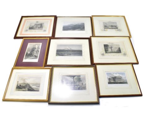
JOHN TALLIS & COMPANY; five mid 19th century maps comprising 'United States', ' North America', 'British America', 'Mexico, California and Texas' and 'East Canada and New Brunswick', a group of approx twenty-five 19th century topographical engravings including North American and coloured examples, two portrait engravings and a modern re-print of a map 'Ghost fleet of the Outer Banks', all framed and glazed.Additional InformationSome visible creasing and spotting/foxing to images, general scuffs and wear to frames.

Lot 610
An early 18th century and later hand coloured map of Bedfordshire, 23 x 16cm, an early 19th century map of Cheshire, a late 18th century map of Yorkshire, an early 19th century map of the East coast of Yorkshire and two 18th century road maps, both detailing Barnsley to Halifax, all framed and glazed (6).Additional InformationGenerally in good condition, a few crease marks, but overall not too bad at all.


Lot 542
A collection of maps, 'Iles Britanniques', 15 x 17cm, framed and glazed, Turkey in Asia by H Moll, 20 x 25cm, framed and glazed, India Proper by H Moll, framed and glazed, 26cm x 20cm, Hertfordshire by Morden, 38cm x 45cm, framed and glazed, Turkey and Asia by Samuel Dann, 35cm x 49cm, framed and glazed, and a portfolio of other maps to include Ottoman Domaine by J Wilde, 60cm x 75cmCondition report: Browning to paper on Samuel Dann map, tears to margins


Lot 687
Two unframed and signed limited edition colour prints of HM Customs Cutter 'Vigilant,' together with a French 'Carte de la Manche', dated 1779, an 1897 Jubilee Fleet Review, hand-coloured print King's Fleet 1778, h/c map Guildford to Portsmouth, h/c 'Map of the World' after B. Baker, G. Edwards map of British Isles dated 1742 etc.

Lot 404
Hampshire & Fareham interest. A quantity of old photos, postcards and pictures of Fareham including photos of Tanners, Red Lion Hotel banquet Room, street scenes, aerial photo etc., four small watercolours, glazed and framed, indistinctly signed, and a Saxton's Map of Hampshire, glazed and framed


Lot 179
AN EARLY RAILWAY MAP,a 'Davies's New Map of the British Metropolis: The Boundaries Of The Boroughs, County Court Districts Railways, And Modern Improvements', 'London: Published for the proprietor by Saunder & Stanford, Oct. 25th. 1852', hand-coloured folding linen backed, in 32 segments,67 x 98cm
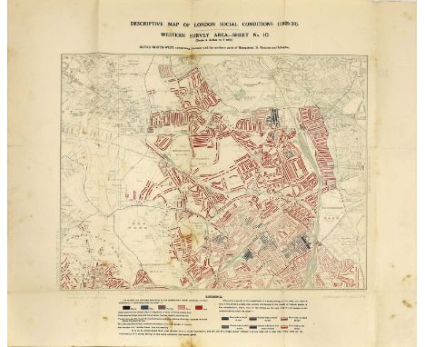
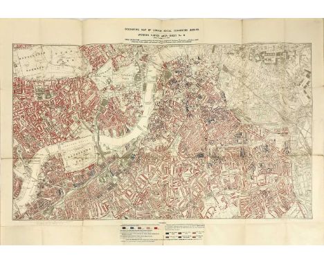
Lot 156
CHARLES BOOTH LONDON SOCIAL CONDITIONS 1929-1930, Charles Booth London Social Conditions 1929-1930, coloured lithograph map (sheet 8) covering Marylebone, Holborn, Finsbury, Paddington, Hampstead, St. Pancras, Islington and Westminster, published by P S King & Son,64 x 79cmCondition report: overall good condition


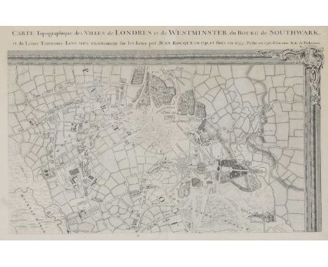
Lot 145
WANSTEAD HOUSE,an early map of Wanstead, Waltham and Leytonstone, by R Parr, titled 'Carte Topographique des Villes de Londres et de Westminster, du Bourg de Southwark, et de Leurs Environs Leve Tres exactement fur les lieux heux par Jean Rocque en 1741, et finis en 1745, publie en 1746, felon une Acte de Parlement', 49 x 68cm, framed


Lot 143
GROWTH OF LONDON MAPS 1901-1902,a complete set of London County Council's 6inch Maps - 'Shewing the Growth of London - Edition 1901-1902', 35 sheets, together with a smaller sheet noting that sheet 30 was not published as the image is on the margin of sheet 24,40 x 56cm (36 sheets in total)Condition report: Generally excellent condition. Very minor creases to edges of some.'Kensington Public Libraries' stamp to the front of each map.


Lot 144
BOWLE'S REDUCED NEW POCKET PLAN OF THE CITIES OF LONDON AND WESTMINSTER 1785,a copper engraved and hand-coloured map of the Cities of London and Westminster laid down on to cloth and folding into the original slipcase,38.5 x 55cmThe Bowles family were successful map publishers and sellers whose considerable output spanned a century. This map is the second, possibly third, edition of an original 1777 plan. Condition report: in excellent condition

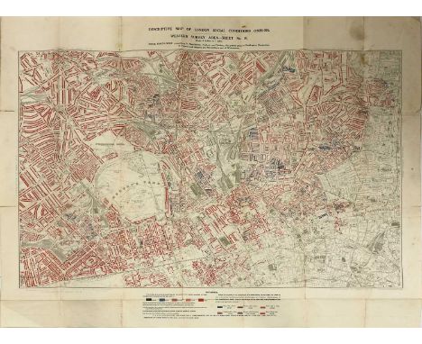
Lot 155
CHARLES BOOTH LONDON SOCIAL CONDITIONS 1929-1930, Charles Booth London Social Conditions 1929-1930, coloured lithograph map (sheet 9) covering Chelsea, Kensington, Westminster and Fulham, Lambeth, Southwark, Battersea and Camberwell, published by P S King & Son,103.5 x 69.5 cmCondition report: overall good condition


Lot 473
Major T. Sherman Royal Marines canvas and leather case, dated 1940 containing Infantry Training Volume IV Tactics 1963 with pen named inscription, 1966 map of Norway named Col. T Sherman, also The Land Battle Part 1 Tactics, and five other training pamphlets, a Royal Marines belt and buckle, silk map of French Indo China and Siam, collection of Royal Marines patches, .303 ammunition box and belt link of empty cases.Sold on behalf of the Royal Marines Reserve MerseysideThe case measures 52cm wide


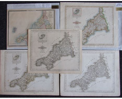
Lot 652
John Carey, Cornwall, hand-coloured map with a vignette of the Scilly Isles, 1787, 23 x 27.5cm, three others, similar and a later hand-coloured book plate map of Cornwall with Edystone lighthouse vignette, with hand-written label, Very scarce first edition before adding the coat of arms, circa 1835, (5).


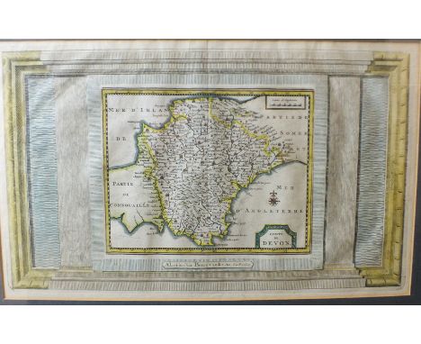
Lot 657
Bowen (Emanuel), "An Accurate Map of Devonshire, Divided into its Hundreds", Bowles & Sayers, hand-coloured map with vignette and plan of Plymouth, 53 x 66cm, together with C & J Greenwood, "The County of Devon from an Actual Survey", 1825/26, dated July 4th 1829, hand-coloured map with vignette of Exeter Cathedral, 61 x 69cm, minor marks and mould patches, (2).


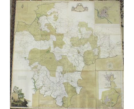
Lot 663
Donn (Benjamin), "A Map of the County of Devon with the City & County of Exeter, Delineated from an Actual Survey by Benjamin Donn, engraved by Thos Jeffreys, Geographer to His Majesty, 1765", hand-coloured map, inset town plans, compass rose, Lundy and title cartouche, 180 x 186, deconstructed in twelve linen-backed sheets.


Lot 665
Pine (J), "A Plott of All the Coast of Cornwall and Devonshire as they were to be Fortified in 1588 against the Landing of any Enemy", uncoloured, engraved map, engraved and published by J Pine, March 25th, 1740 according to Act of Parliament, decorative cartouche and engraved scrolling frame, 41 x 67.5cm.


Lot 669
Owen & Bowen, "Map of Devonshire, the Road from Bristol to Exeter", 19.5 x 13.5cm, and 18th century strip road map "Dartmouth to Newton Bushel", 19 x 12.5cm, Sayer & Bennett, a strip road map "Exeter to Dorchester, Plymouth to Dartmouth", 1775, 17 x 21cm and Carrington Bowles, "Exeter to Newton Bushel", 17.5 x 10cm, (4).

Lot 670
An 18th century double-map, "A Modern Map of Cornwall and Modern Map of Devonshire for Walpoole's New and Complete British Traveller", pub: Alex. Hogg, circa 1784, 35 x 22cm, Blome (Richard), "A Map of Devonshire with its Hundreds", an uncoloured map, 27.5 x 33cm, Van Den Kerre, a 17th century book plate map, "Devonia", 12 x 9cm, (3).


Lot 684
Railwayana: a Southern Region Suburban Services mirror, polychrome printed with the network map, 41 x 61cm (circa 1960s/70s) slight deterioration to silvering in patches - does not obscure the image; losses to slivering on top edge and scratches by Wallington (lower centre); some surface scratching

Lot 718
J A Knipe - 'Geological & Mineralogical Map of England and Wales with parts of Scotland, Ireland & France...' with forty-nine linen-backed sections, published 1884, 116 x 85 cm overall, with oil-paper ends, contained in cloth-bound slip-case with paper label for Edward Stanton (retailer) of Charing Cross
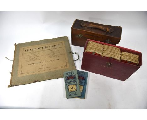
Lot 719
A 19th century German linen-backed folding shipping chart of the world, in eight sections with linen backing, 95 x 153 cm overall by Hermann Berghaus & F von Stúlpragel, Gotha 1867, in card slip, to/w a leather-cased set of Batholomew's Map of England and Wales, pub Sifton, Praed & Co Ltd (map 33 - Hampshire -missing), linen-backed (case a/f) and a similar later cloth-bound case of twenty three Bartholomew Quarter-Inch Automobile Maps of Great Britain, linen-backed (3) a/f

Lot 115
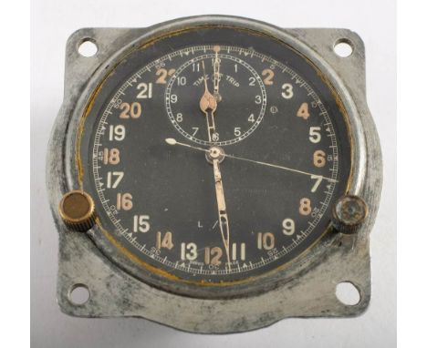
A WWII Spitfire cockpit clock Mk IIIB, by Smith & Son, London: black dial with 24 hour luminous Arabic numerals, time trip dial at 12 o'clock position, sweep seconds, the dial stamped as per title, the brass casing stamped to back with crown and 'AM' cipher, also 'Brevet Suisse 111.406' to one side, 9.5cm wide, together with a WWII period green leather cushion with map pocket under, (2).

-
109182 item(s)/page