We found 109198 price guide item(s) matching your search
There are 109198 lots that match your search criteria. Subscribe now to get instant access to the full price guide service.
Click here to subscribe- List
- Grid
-
109198 item(s)/page


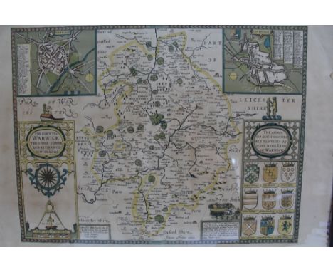
Lot 37
Attributed to John Ogilvy - "The Road from Oxford to Cambridge - The Arms of the College's, etc., in Oxford...", engraving coloured by hand, 18.3 x 12cms (plate size); together with a miniature map of Yorkshire, possibly after William Green, 12 x 8.8cms (image size), in none-matching frames. (2)


Lot 668
[Jean-Baptiste Christyn]: 'Het schouwburg der Nederlanden ... beschryvinge der XVII. Nederlandsche provintien', Antwerp, 1785, 5 vol. -- Description: [Jean-Baptiste Christyn]: 'Het schouwburg der Nederlanden ofte geographische en historische beschryvinge der XVII. Nederlandsche provintien', Antwerp, C.M. Spanoghe, 1785, 5 vol.Ê I: 12mo: Front. (dated 1786)-[2]-310 pp., 31 pl. (incl. the map of the 17 provinces and 27 folding plates). Ê II: 12mo: Front. (dated 1786)-443pp., 38 folding pl.Ê III: 12mo: Front.-372pp., 38 folding pl.Ê IV: 12mo: Front. (dated 1786)-397pp., 20 pl. (of which 19 folding plates).Ê V: 12mo: Front. (dated 1786)-348pp., 29 pl. (of which 27 folding plates).Ê Later half calf, gilt flat spine, leather title label, by F. Schmitz (Maastricht). With ownership entries (ex-libris Lud. (baron?) de Crassier; 2 oct 1895).
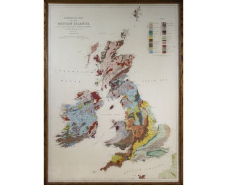
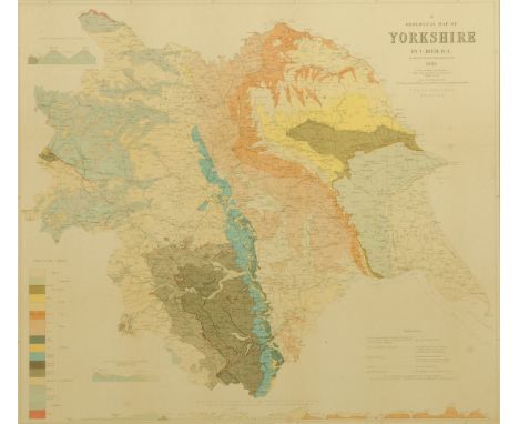
Lot 123
RARE GEOLOGICAL MAP of the British Isles, based on the works of the geological survey by J J H Teall, MA. Lld .SC. F.R.S director 2nd edition 1912 SCALE OF TWENTY FIVE STATUE MILES TO ONE INCH/1584000. Engraved at the ordnance survey office, Southampton, price uncoloured one shilling. coloured two shilling. Frame and glazed in original oak frame a good clean impression of this rare coloured map size 35" x 25"


Lot 120
Golden Cockerel Press.- Chair (Somerset de) The Silver Crescent, number 18 of 30 specially-bound copies, signed by the author, from an edition limited to 500, photographic illustrations, map endpaper, original blue crushed morocco by Sangorski & Sutcliffe, spine faded, some occasional light rubbing to extremities, 8vo, 1943.
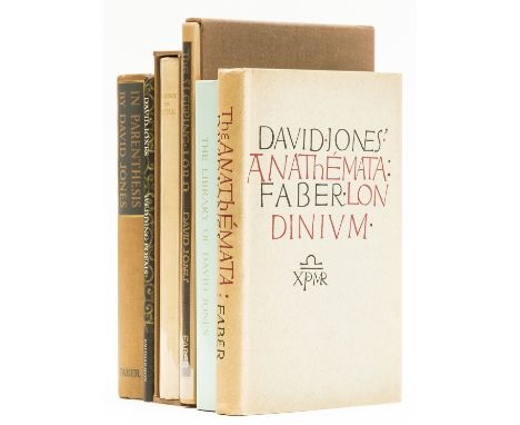
Lot 127
Jones (David) In Parenthesis, first edition, frontispiece, plate and map by the author, a few pencil annotations to preface and small markings to text, small book-label to rear pastedown, original beige cloth, spine a little browned but a good copy, 1937; The Anathemata, first edition, plates, Evan Gill's copy with his book-label, original cloth, dust-jacket, not price-clipped, spine lightly browned, 1952; The Sleeping Lord, number 143 of 150 copies signed by the author, frontispiece, original cloth, slip-case, 1974 § Jones (Huw Ceiriog) The Library of David Jones (1895-1974): A Catalogue, original cloth, dust-jacket, Aberystwyth, 1995 § Coventry (Francis) The History of Pompey the Little..., one of 400 copies, wood-engraved frontispiece and tail-piece by David Jones, leather book-label of Micheline & Mervyn Parkhouse, original cloth-backed boards, uncut, lower corners slightly bumped, slip-case, Waltham St. Lawrence, Golden Cockerel Press, 1926 § Leslie (Shane) Fleet Street, The New Broadside No.16, 2 colour illustrations by David Jones, c.430 x 190mm., tipped into aperture mount, Poetry Bookshop, [c.1926]; and a bundle of others by or relating to Jones including several prospectuses for his works, v.s. (sm.qty)

Lot 144
Schanilec (Gaylord).- Logue (Mary) A House in the Country, number 73 of 250 copies signed by the author and artist, original cloth-backed cloth, 1994 § Schanilec (Gaylord) YTWOK: A Chronological Miscellany of Images...engraved during the Second Millennium..., number 38 of 99 copies signed by the artist, original cloth-backed boards, uncut, 1999 § McGrath (Thomas) The Bread of this World; Praises III, number 173 of 210 copies, original limp boards sewn in Japanese style, 1992 § Arey (Richard Fred) Waterfalls of the Mississippi, number 92 of 226 copies signed by the author and artist, folding map, original pictorial cloth, gilt, uncut, slip-case, St. Paul, Mn., Minnesota Outdoors Press, 1998 § McCarriston (Linda) & others. Hungry Midnight 3, 6 broadsides of poems, title printed in red & black on thick paper and numbered 23/30 & signed by the artist, poems each numbered 23 of between 80 and 100 copies and signed by the author, loose in original cloth portfolio, 1999, all with colour wood-engravings by Gaylor Schanilec, all but the fourth Minneapolis or Stockholm, Wi., Midnight Paper Sales; and 5 others with colour wood-engravings by Schanilec including 2 loose broadside poems and a prospectus, v.s. (10)
![Eliot (T.S.).- Jones (David) In Parenthesis, [with an introduction by T.S.Eliot], number 5 of 70 copies signed by the author](https://cdn.globalauctionplatform.com/c80d5540-6644-4de5-a369-ac2400b1ba5c/f4e2acb1-7b84-4c52-b79d-ac2400b3666c/468x382.jpg)
Lot 15
Eliot (T.S.).- Jones (David) In Parenthesis, [with an introduction by T.S.Eliot], number 5 of 70 copies signed by the author & T.S.Eliot, frontispiece, plate and map by the author, original blue buckram, t.e.g., 8vo, 1961.⁂ An excellent copy of the author's first book, a prose poem based on his traumatic experiences in the trenches of the First World War. It was first published through T.S.Eliot at Faber & Faber in 1937 and is described by Eliot in his introduction as "a work of genius".
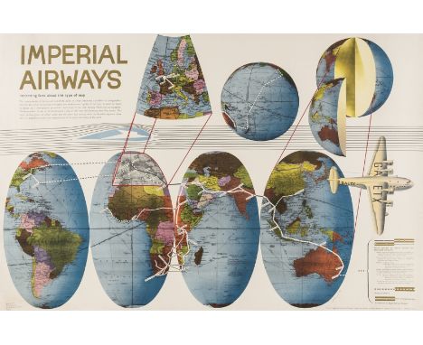
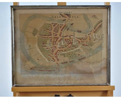
Lot 205
Erni (Hans) Imperial Airways, map of the world presented across four gores with airway routes included, lithograph printed in colours, mounted on linen, sheet 635 x 1020 mm (25 x 40 in), several areas of restoration to nicks and loss, old folds, some minor surface dirt, unframed, Curwen Press, 1938.
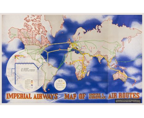
Lot 213
Moholy-Nagy (Laszlo) Imperial Airways/Map of Empire & European Air Routes, lithograph printed in colours, on thin wove paper, unlined, sheet 630 x 1010 mm (24 3/4 x 39 3/4 in), old folds, minor nicks and tears to extremities, unframed, Curwen Press, 1936⁂ Moholy-Nagy's tribute to Henry Beck's recently designed and published London Tube Map (1933).

Lot 317
Books - Barrett, William, FSA - History and Antiquities of the City of Bristol, printed by William Pine in Wine-Street, dedication dated 1789, in half calf and marbled boards Condition: Some brown spotting to folding map, title page and dedication page, a few other pages with light brown staining, contents not collated and sold as seen, later binding. **General condition consistent with age

Lot 322
Local Interest - George C. Ashmead - Plan of the City of Bristol and its Suburbs, hand-coloured two-part folding map, of thirty-six sections on two linen-backed halves, overall 150cm x 203cm, in original hide book-form slip-case Condition: Linen backing is probably of later date and has small loss to edge of one panel. Contents remarkably fresh and bright, only very minor brown staining to a couple of panels. Hide case is dry and scuffed, sun faded and with losses to title plus 'dogeared' ends. **General condition consistent with age

Lot 341
Bowen (Eman.) - 'An accurate map of the County of Essex divided into its Hundreds', 18th Century, hand coloured, 55cm x 73cm Condition: Vertical line of discolouration to the centre seam, some other minor discolouration, plate mark visible, three vertical tears/creases visible middle top, the longest ectending approx 5cm, unclear wether the map is laid down on the board. **General condition consistent with age


Lot 516
Red stained Royal Commemorative chair, for the investiture of H.R.H. the Prince Charles, July 1969, with gilt crest to the back, designed by Anthony Armstrong Jones (Lord Snowdon), belonging to a Mr & Mrs D.G. Hopkin, 76cm high x 56cm wide, together with two admittance tickets, invitation card, two order of services, official souvenir programme with map, a quantity of related ephemera etc Condition: Some knocks and scratches to the wood in places, the wooden back having small red section missing towards the top, some discolouration and staining to padded seat, would advise viwing in person prior to bidding. **General condition consistent with age

Lot 1263
S. S. STEWART, PHILADELPHIA. A LATE AND VERY RARE 19TH CENTURY FRETLESS BANJO CIRCA 1890-93 with map inlays, ivory pegs and a metal fingerboard up to the fifth fretmarker, with ivory maker's palque which reads "S. S. STEWART PHIL'A. PA" along with identical wood stamp, serial no. 6124 and trademark S.S.S. all stamped to the dower stick with matching stamps to inside rim, lacking tailpiece, bridge, nut, 3 x tuning pegs and several inlays. 0 - 12th fret = 322mm. 85.5cms overall (64.5cms Scale).


Lot 1211
Switzerland Its Mountains, Valleys, Lakes and Rivers new ed. 1889, London, 4to orig. gt. dec. cl. plus Emigrants Guide to the south African Gold & Diamond Fields 10th. ed. 1885, lacks sp. plus BLANEY, H.R. Old Boston 1st.ed. 1896, Boston, 4to orig. gt. dec. cl. plus 4 others & 1 map (8) Est. £30 - £50.

Lot 1213
BRUCE, J. Travels to discover the source of the Nile: in the years 1768, 1769, 1770, 1771, 1772, and 1773 6 vols. 1790-1791, Dublin, 8vo cont. quarter cl. bds. with 59 numbered engrvd. plts. as called for incl. 1 leaf Ethiopian script plus 2 (of 3) fldng. maps at rear of Vol.VI (missing map appears never to have been bound in) Vols. I-V lack half titles. Est. £300 - £500.


Lot 624
A large collection of WWII transport related ephemera and books to include: Ford at War, The Battle of Britain by Ira Peck, The King's Empire, Aircraft of the Battle of Britain, Marvels of To-Day An Illustrated Map of the Thames from Westminster Bridge to Tilbury Docks Shewing the Position of the Ford Works at Dagenham Essex, The Aeroplane Simply Explained, Roof Over Britain and many more.


Lot 127
James Malton (1761-1803) A Picturesque and Descriptive View of the City of Dublin Described. In a series of the most Interesting Scenes taken in the year 1791. By James Malton. With a brief authentic history from the earliest accounts to the present time. Engraved titlepage and dedication, Arms of Dublin, A Correct Survey of Dublin as it stood in the year 1610, A Correct Survey of the Bay of Dublin 1795, and twenty-five plates of views. London: 1803. This volume also included the Faden Map of A Plan of the City of Dublin...1797 This map only appeared in a few of the volumes Oblong folio. Dark Blue half calf binding. A very good set of this exceedingly rare topographical work. The plates are as follows: Great Courtyard, Dublin Castle; The Parliament House; Trinity College; College Library; Provost's House; St. Patrick's Cathedral; West Front of St. Patrick's Cathedral; Royal Exchange; Custom House; View of the Law Courts, looking up the Liffey; Tholsel; Old Soldiers Hospital, Kilmainham; Royal Infirmary, Phoenix Park; Blue Coat Hospital; Lying-in Hospital; Rotunda New Rooms; St. Catharine's Church; Marine School; Leinster House; Charlemont House; Powerscourt House; View of Capel Street, looking over Essex Bridge; St. Stephen's Green; Barracks; View of Dublin from the Magazine, Phoenix Park. Dedicated to the Governors and Directors of the Hospital, including the College Library, dedicated to Edmund Burke. Besides the above twenty-five views the bound volume contains the Arms of Dublin, as frontispiece; Survey of the City of Dublin as it stood in 1610, taken from Speed's Map; Survey of the Bay of Dublin, 1795, and a folding map of Dublin by Faden . At the end of the volume is a plate with two outline Keys - one of the smaller View of Dublin from the Park, the other of the smaller view of the Barracks. All the plates are inscribed James Malton del. et fecit

Lot 25
BOWYER, Robert, An Illustrated Record of Important Events in the Annals of Europe. Folio, 1816. Bound with The Campaign of Waterloo, 1816. First work has 19 hand coloured aquatint plates, 4 of which are double-page, plus one map, one plate of portraits and one plate of signatures. Second work has 4 hand-coloured plates, one of which is double page, plus 1 map and 2 plates of portraits. A few of the black and white plates have illustrations pasted to the versos. Colour plates are very clean. Contemporary half morocco.


Lot 878
A collection of Alfred Wainwright related booklets, maps and ephemera, nine calendars, notelets and envelopes, an antiquarium map of Cumbria and a collection of publications containing early drawings by Wainwright Exploring Eskdale, Exploring the High Fells, Museum of Lakeland Life and Out of Doors magazines.


Lot 242
Tank Corps 1919 South Russia Photographs of Captain R.F Shaw. MBE A rare selection of original personal “snap shot” photographs taken by Captain Reginald Frank Shaw MBE Tank Corps whilst attached to the White Russian Forces in 1919/1920. Images include: Tank Corps offloading tanks in the port, tanks being loaded onto trains, Officers and men of the tank corps, Russian officers and Cossacks with the tanks, A small dancing bear with a British officer . Together with a small selection of Captain Shaw post war. …. Also His canvas covered folding map case…Hand written training book…Field service pocket book named Reginald Shaw. (small quantity)

Lot 384
WW2 1944 Bomber Command Distinguished Flying Cross Medal Group & ArchiveA large archive of Flight Lieutenant Alan Frederick Forsdike DFC. MID, who flew as a Navigator on Halifax Bombers of 158 & 78 Squadron 4 Group. Comprising: Medal Group Distinguished Flying Cross (1944 with box & Buckingham Palace letter), 1939/45 Star, Bomber Command Clasp (loose in original box of issue with name), Aircrew Europe Star, Defence Medal, War Medal, MID Oak Leaf. Group mounted as originally worn. The medal group is accompanied by an extensive archive which includes Observer’s & Air Gunner’s Log Book covering the period 3rd September 1940 to 6th July 1947 and records 41 operations with 78 and then 158 Squadrons. ... Large number of photographs, letters, escape map, uniform badges etc.PLEASE NOTE This lot is being sold on behalf of the Leonard Cheshire Homes CharityThe announcement of the award of the Distinguished Flying Cross appeared in the London Gazette on the 19th May 1944.“158 Squadron. This Officer has participated in a large number of attacks on enemy targets including such centres as Berlin, Hamburg, Essen, and Kassel. He is a navigator of high merit whose example of courage, and determination has been inspiring. He has proved his skill in many difficult situations and his efforts have contributed greatly to the successes obtained.”Flight Lieutenant Alan Frederick Forsdike, joined the RAF in 1940 and volunteered for aircrew, selected as a navigator he took his first flight on the 3rd September 1940. After training in Canada and various training units he was posted to 78 Squadron operating the Halifax bomber and flew his first operation to Aachen on the 13th July 1943. A comment in the log book states for this first op “incendiary in belly, No Gee nearly bailed out” the trip took 6 hours. In January 1944 part way through his tour of operations he appears to have transferred to 158 Squadron again a Halifax Bomber Squadron and completed his tour on the 1st May 1944 with a trip to Malines, this being his 41st trip. The log as a large number of pencil details of raids. After the war he left the RAF and worked as a teacher in Brighton. He maintained close links with both Squadron Associations.
-
109198 item(s)/page