

Vincent (Frank). The Land of the White Elephant: Sights and Scenes in South-Eastern Asia. A Personal Narrative of Travel and Adventure in Farther India, Embracing the Countries of Burma, Siam, Cambodia, and Cochin-China. (1871-2), 1st edition, Harper & Brothers, New York, 1874, double page colour map, wood-engravings, publisher's list at end, original cloth gilt, edges a little rubbed, 8vo, together with An Australian in China. Being the Narrative of a Quiet Journey across China to British Burma, by G.E. Morrison, 1st edition, 1895, folding maps, illustrations, a little light spotting, top edge gilt, original cloth gilt, spine faded, 8vo, plus Chow-Chow; Being Selections from a Journal Kept in India, Egypt, and Syria, by the Viscountess Falkland, 2 volumes, 2nd revised edition, 1857, colour frontispiece to each (volume I with marginal water stain), a few spots, original blindstamped cloth, light edge wear, 8vo, with six others including Edwin Dingle's Across China on Foot, 1911, Edgar Thurston's Ethnographic Notes in Southern India, 1st edition, 2nd issue, 1907 and Two Years in the Forbidden City, by the Princess Der Ling, 1912 (10)
We found 109182 price guide item(s) matching your search
There are 109182 lots that match your search criteria. Subscribe now to get instant access to the full price guide service.
Click here to subscribe- List
- Grid
-
109182 item(s)/page
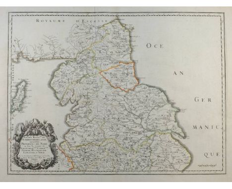
Flintshire. Speed (John), Flint-shire, published John Sudbury & George Humble, circa 1627, uncoloured engraved map, inset town plans of Flint and Saint Asaph, inset vignette of St. Winifred's Well, splits to central fold, some worming affecting image, 385 x 510 mm, English text on verso, together with Saxton (Christopher & Hole William), Caernarvo. comitatus pars olim ordovicum, [1637], uncoloured engraved map, large strapwork cartouche, compass rose and numerous rhumb lines, 255 x 315 mm (2)


Hulbert (C.). Volcanic Wonders, and Scenes of Astonishment: Being Historic and Scientific Descriptions of the Volcanoes of the Azores, and a General View of Burning Mountains, in Various Parts of the Globe, 2nd edition, Shrewsbury, 1827, single page engraved map, five engraved plates, some offsetting and scattered spotting, original cloth-backed boards, paper label to upper cover, upper joint splitting, some paper loss to boards, 4to (1)
South west England. Mercator (Gerard), Cornubia, Devonia, Somersetus, Dorcestria, Wiltonia, Glocestria, Monumetha, Glamorga, Caermarde, Penbrok, Cardigan, Radnor, Breknoke, Herefordia et Wigornia, circa 1636, hand coloured engraved map, some marginal repairs not affecting image, 370 x 470 mm, English text on verso, together with Sanson (Nicolas), Anciens Royaumes de Mercie et East-Angles ou sont les comt‚s ou shires de Chester, Darby, Nottingham, Lincolne, Rutland, Leicester, Stafford, Shrop-sh, Hereford, Worcester, Warwick, Northampton..., [and] Ancien Rouaume de Northumberland aujourhuy Provinces de nort..., published Paris, 1654 & 1658, two engraved regional maps with contemporary outline colouring, slight creasing, each approximately 380 x 510 mm (3)
South Africa. Wood (John, compiler), Imperial Map of South Africa Compiled for Field Intelligence Department, Cape Town, 1900, lithographic map, sectionalised and laid on linen, slight staining and abrasion, 900 x 1100 mm, together with Map of the Colony of the Cape of Good Hope and Neighbouring Territories. Compiled from the best available information, 1895, folding lithographic map, laid on linen, 770 x 925 mm, contained in contemporary cloth boards with a reference key to verso of upper cover, boards ink stained and faded, with Wood & Ortlepp (compilers),Briton or Boer West, published Cape Town & Johannesburg, 1900 folding lithographic map, laid on linen, 480 x 600 mm, contemporary printed green cloth boards, with three other maps similar, various sizes and condition (6)
Phillips (John). Illustrations of the Geology of Yorkshire; or, A Description of the Strata and Organic Remains: accompanied by a geological map, sections, and plates of the fossil plants and animals, 2 volumes, 2nd edition, 1835, single-page hand-coloured engraved geological map, 9 sectional plates, including 7 hand-coloured, and 12 uncoloured lithographed plates of fossil specimens, some light marginal spotting to fossil plates, contemporary boards, rubbed and marked, spines renewed, 4to, together with others on the geology of Yorkshire, including Thomas Hurtley, A Concise Account of Some Natural Curiosities, in the Environs of Mallam, in Craven, Yorkshire, 1786, bound in modern half-calf, 8vo, Josiah Bewick, Geological Treatise on the District of Cleveland, in North Yorkshire, its Ferruginous Deposits, Lias, and Oolites; with some observations on ironstone mining, 1861, John Weale, 1861, with large folding hand-coloured map, 2 folding coloured sections, 2 coloured plans and 2 tables, bound in original publisher's gilt-decorated black morocco (by Andrew Reid, Newcastle-on-Tyne), rubbed and scuffed to joints, with upper joint partly cracked, 8vo, author's presentation copy to T.H. Wilkinson, with inscription to front pastedown, and John Hutton, A Tour to the Caves, in the environs of Ingleborough and Settle, 2nd edition, with large additions, 1781, some staining, bound in modern full calf gilt, 8vo (5)
Crete. Coronelli (Vicenzo Maria), Coste Maritime dell' Isola di Candia con tutte le Baye e Porti di essa..., published Venice, circa 1695, uncoloured engraved map, compass rose and numerous rhumb lines, some staining to central fold, 395 x 520 mm, together with Paralello Geografico dell' Antico col Moderno Archipelago..., [and] Parte Meridionale dell Archipelago..., published Venice, circa 1695, two uncoloured engraved maps of the Northern and Southern Aegean sea, slight staining to central folds, each approximately 455 x 605 mm, Italian text and small engraved maps to verso, with Isola di Cipro, published Venice, circa 1695, uncoloured engraved map with Italian text below, on verso and to the sides of the map, map size 125 x 165 mm (4)
Lyell (Charles). Principles of Geology: Being an Inquiry How Far the Former Changes of the Earth's Surface are Referable to Causes now in Operation, 4 volumes, 3rd edition, John Murray, 1834, half-titles present, 14 maps and plates including some folding and 5 hand-coloured, engraved illustrations to text including some full-page, occasional offsetting and spotting, mostly affecting plates, 1 map with crudely taped closed tear repair to verso, a few minor ink marginalia, modern half calf with gilt-title, lacks spine labels, 8vo (4)

Martin (Martin). A Description of the Western Islands of Scotland..., 2nd edition, 1716, large folding linen-backed engraved map (detached, torn with slight loss, dust-soiled & few marks), folding engraved plate, dust-soiling and few marks, contemporary blind panelled calf, light wear to joints & extremities, 8vo, together with Headrick (James), View of the Mineralogy, Agriculture, Manufactures and Fisheries of the Island of Arran. With Notices of Antiquities, and Suggestions for improving the Agriculture and Fisheries of the Highlands and Isles of Scotland, published Edinburgh, 1807, folding engraved map frontispiece (close trimmed to ruled border & small tear to edge), occasional spotting, top edge gilt, 20th century dark green half morocco gilt, 8vo (2)
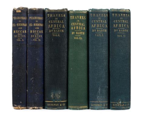
Burton (Richard Francis). Personal Narrative of a Pilgrimage to El-Medinah and Meccah, volumes I & II (of 3) only, 1st edition, 1855, tinted lithograph frontispiece, folding engraved map and 2 colour lithograph plates to first volume, colour lithograph frontispiece, 2 tinted lithograph plates, and 2 engraved plans (one folding to second volume), 24-page publisher's catalogue at rear of first volume, occasional minor marks, frontispiece to first volume loose and slightly frayed to extreme fore-edge, endpapers to each volume with remains of old library labels, original blue cloth gilt, rubbed and some marks, with some fraying to joints and extreme head and foot of spines (second volume detached along rear joint), 8vo, together with Barth (Henry), Travels and Discoveries in North and Central Africa: being a journal of an expedition undertaken under the auspices of H.B.M's. Government, in the years 1849-1855, volumes I-III, 2nd edition & volume V, 1st edition (of 5 in total), 1857-58, half-title to volume I only, 13 folding engraved maps (occasional light offsetting, one map to fifth volume torn without loss), 46 tinted lithograph plates, errata leaf at end of volume V, third volume with light waterstain to lower outer corners of plates, several inner hinges partly cracked, original blindstamped green cloth gilt (third volume in slightly non-matching lighter green cloth), rubbed and some marks, second volume with old bookplate of Bury & West Suffolk Library to front pastedown, all 8vo Abbey Travel 368 & 274 respectively. Ghani 62 for the first work. Ibrahim-Hilny I, 54 for the second work. (6)


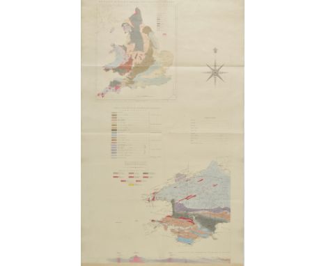
British Isles. Knipe (James A.) Geological Map of the British Isles and part of France, Showing also the Inland Navigation by means of Rivers and Canals, The Railways and Principal Roads and Sites of the Minerals, under the Patronage of His Royal Highness Prince Albert..., published H.Bailliere and Messrs. Grant & Griffith (late Harris), 1st edition [3rd state], 1845, engraved map by J.Dower, contemporary hand colouring, sectionalised and laid on linen on four sheets, each sheet with marbled endpapers and a small printed outline map to upper endpaper, large calligraphic title surmounted by the royal coat of arms, inset map of the Orkney and Shetland Islands, inset geological reference and table of explanation, seven geological cross sections and two diagrams of artesian wells, three very small ink spots to North East sheet, each sheet approximately 770 x 660 mm, contained in a contemporary green gilt morocco slip case with 'envelope style' lid (lid detached), gilt decorated spine and gilt royal crest to front board, worn at extremities (1)
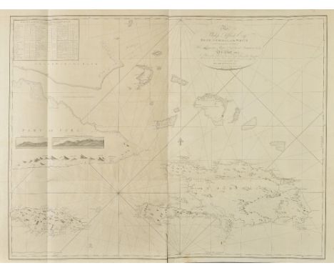
Leard (John). Leard's Pilot for Jamaica and the Windward Passages, surveyed by order of Vice Admiral Affleck and published by permission of the Right Honourable the Lords of the Admiralty, Mount and Davidson, circa 1793, title on printed label to upper board, title and front pastedown with slightly later manuscript ownership signature of Auguste Booquet Capn. au Long-cours, dated 1827, 14 (of fifteen) uncoloured engraved charts, including five double page and/or folding, slight spotting and water staining throughout, one map with short closed tear, hinges and joints cracked and weak, contemporary marbled boards, with large printed label to upper cover, some soiling and staining, and wear to edges, joints partly cracked, large slim folio (590 x 330 mm) Very rare pilot book. The last copy we can find recorded for sale in an auction was 1937. No institutional copies found, although the Library of Congress holds a pilot of fifteen maps with a different title. Examples of a few of the maps contained in this volume are held by the Biblioteca Nacional de Madrid and the British National Archives but no complete example appears to exist. Admiral Philip Affleck was Rear Admiral of the White and Commander in Chief of his Majesty's naval contingent in Jamaica and Bermuda between 1789 and 1792. During his time in command Affleck undertook a comprehensive marine survey of Jamaica and its surroundings. He was assisted by John Leard and William Buller. Affleck did produce a very rare 115 page nautical guide titled 'Sailing directions for the island of Jamaica and St. Domingue, or Hispaniola, and the windward passages; to be used with the charts and plans that are published from surveys and observations, made by orderof Philip Affleck .... in part of the years 1789, 1790, 1791, and part of 1792 ... prepared with the assistance of Leard in 1792'. Two examples appear to survive: one in the collection of the American Philosophical Society and the other in the National Archives of Australia. This pilot may be part of that larger work. Provenance: French 'Long-Cours' Captain Auguste Booquet belonged to the elite master mariners of the sailing world, who undertook the long course or long haul route around Cape Horn in pursuance of their trade. The title was not introduced until 1825. It is possible that this pilot was acquired by a French man of war during the Napoleonic wars. (1)
[Brome, James]. An Historical Account of Mr. Rogers's Three Years Travels over England and Wales, 1st edition, printed and sold by J. Moxon, and B. Beardwell, 1694, folding engraved map at front, entitled 'A New Mapp of England & Wales' (soiled and with some loss and repairs to edges, relined), title with some soiling and restrengthened to lower half of fore-edge and towards upper inner margin, some marks and soiling to text, late 19th or early 20th century calf gilt, rubbed and some minor wear, small 8vo, together with [Clarke, Edward Daniel]. A Tour Through the South of England, Wales and part of Ireland, made during the summer of 1791, printed at the Minerva Press, 1793, 11 partly-folding tinted aquatint plates, some manuscript bibliographical notes in pencil and ink to verso of half-title and title page, signature of Anne Chatfield, 1793 to front pastedown, contemporary full calf, rubbed and some wear with joints cracked, plus Arbuthnot (John), The Miscellaneous Works of the late Dr. Arbuthnot, 2 volumes, Glasgow, James Carlile, 1751, modern antique-style quarter calf with black morocco spine labels, 8vo (4)
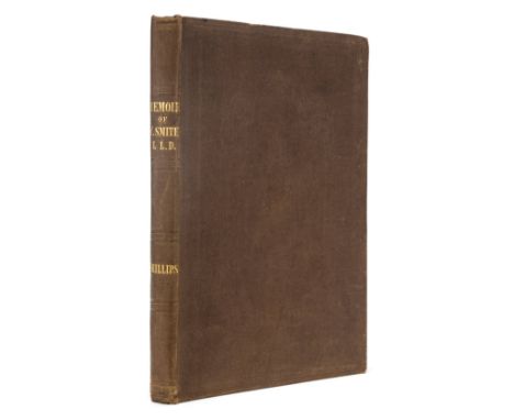
Phillips (John). Memoirs of William Smith, LL.D., Author of the "Map of the Strata of England and Wales", by his Nephew and Pupil John Phillips, 1st edition, 1844, engraved portrait frontispiece, four profile portraits, one in silhouette (light offsetting), illustrations, publisher's list at end, a few light spots, original brown blindstamped cloth, spine lettered in gilt, 8vo Only 500 copies printed. A good copy. (1)
Mantell (Gideon). The Geology of the South-East of England, 1833, lithograph frontispiece and five plates (one folding), folding hand-coloured engraved geological map at rear (some folds strengthened to verso), wood engraved vignette to title and numerous illustrations throughout volume, partly uncut, 16pp. publisher's catalogue at front, occasional scattered spotting, modern half calf, 8vo, together with Brande (William Thomas), Outlines of Geology; being the Substance of a Course of Lectures Delivered in the Theatre of the Royal Institution in the Year 1816, John Murray, 1817, folding hand-coloured engraved frontispiece of the Strata from London to the coast of Cornwall, label removed from front pastedown with consequent adhesive residue, original cloth, joints cracked and slightly frayed, spine faded & repaired at head & foot, removed library stamp at foot of spine and label to upper cover, 8vo, plus Royal Institution, A Descriptive Catalogue of the British Specimens deposited in the Geological Collection of the Royal Institution, 1816, 8pp. publisher's catalogue at rear, modern half calf, 8vo (3)
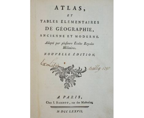
Brion de la Tour (Louis). Atlas, et Tables ‚l‚mentaires de G‚ographie, ancienne et moderne; Adopt‚ par plusiuers Ecoles Royales Militaires, Nouvelle dition, published Paris, 1778, additional half title, title page with near contemporary manuscript owenership signature, twenty (complete as list) double page engraved maps with contemporary outline colouring, occasional spotting and staining, map of the world with split along central fold, one map near detached, hinges weak and cracked, old pencil annotations to front pastedown and front endpaper, contemporary marbled boards with manuscript label to upper board, lacking spine, rubbed, worn and frayed, 8vo (1)
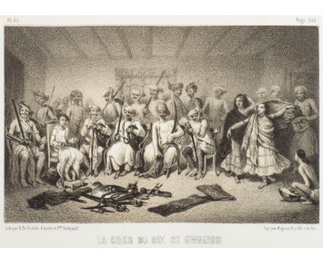
Soltykoff (Alexis). Voyages dans l'Inde, 2 volumes, 2nd edition, Paris, Curmer & Lecou, 1851, additional title printed in gold with wood engraved vignette to each volume, half-titles, single-page map to first volume, 36 tinted lithograph plates, some spotting throughout, all edges gilt, original elaborately gilt-decorated black cloth, incorporating pink, red, green and blue morocco onlays, minimally rubbed, generally in remarkably bright condition, large 8vo Prince Aleksei Dmitrievich Soltykoff (1806-1859) was a Russian traveller and artist, gave up his diplomatic career to plan his two voyages to India of 1841-43 and 1845-46, during which he both drew and described the people and scenery of New Delhi, Madras, Ceylon, Calcutta, Lahore, and elsewhere. Remarkable copy in a deluxe oriental-style binding. (2)

Cyprus. Coronelli (Vicenzo Maria), Carta maritima dell' Isola Cypri dismostrante le meridionali coste, published Venice, circa 1695, uncoloured engraved chart on two conjoined sheets, inset map of 'Coste maritime di Egytto d'Alessandria sino a Damiata' (the coast of Egypt between Alexandria and Damiata), slight worming to upper margin, two worm holes to image, 395 x 520 mm (1)
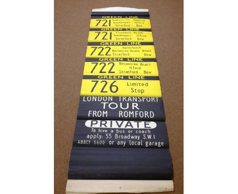
England & Wales. Bellin (Jacques Nicolas), Carte R‚duite des Isles Britanniques en cinq feuilles..., par ordre de M. de Machault..., published Paris, 1757, large hand coloured engraved map on two conjoined sheets, one repaired small hole affecting image, occasional repaired closed tears, two decorative cartouches, compass rose and numerous rhumb lines, stamp of the Depot de la Marine, 1000 x 880 mm, together with four large wall maps showing the World, England & Wales and estates, all in very poor condition with numerous tears, loss and damage, plus a very large 'bus destination roller' black and yellow lithography laid on canvas, showing stops at Hornchurch, Stratford, Bow, Chadwell Heath, Ilford, Romford, Private Hire and others, 2920 x 830 mm, appears unused (6)

Canary Islands. Coronelli (Vicenzo Maria), Isole Canarie, published Venice, circa 1695, uncoloured engraved map, decorative cartouche and mileage scale, inset 'fringed curtain' containing a map of the island of Madiera and the port of Funchal, compass rose and numerous rhumb lines, slight worming to upper margin just affecting plate mark, Italian text and an engraved vignette of Tenerife to verso, 455 x 605 mm, together with Isola Canarie gia dette Fortunatae Ins., published Venice, circa 1695, uncoloured engraved map, 225 x 305 mm (2)
Shropshire. The Shropshire Gazetteer, with an Appendix, including a Survey of the County, and Valuable Miscellaneous Information, bound in two volumes, Wem: Printed & Published by T. Gregory, 1824, folding engraved map frontispiece, twenty-two lithograph plates and one wood-engraved plate, occasional light spotting, contemporary gilt & blind decorated calf, 8vo (2)
Murchison (Roderick Impey). The Silurian System, Founded on Geological Researches in the Counties of Salop, Hereford, Radnor, Montgomery, Caermarthen, Brecon, Pembroke, Monmouth, Gloucester, Worcester, and Stafford; With Descriptions of the Coal-Fields and Overlying Formations, 2 parts in one, 1st edition, 1839, 3 engraved maps, 14 lithographed plates, including 2 folding and 3 hand-coloured, 9 folding hand-coloured geological sections, EACH SIGNED AT FOOT BY MURCHISON, 31 engraved plates of fossils, some spotting and water stains, mainly to uncoloured plates, occasional pencil annotations, hinges reinforced, contemporary brown half morocco, rebacked with original spine relaid, a little rubbed, 4to, COMPLETE WITH THE RARE ENGRAVED HAND-COLOURED GEOLOGICAL MAP, in three linen-backed sections, the third section signed at foot by Murchison, unobstrusive library blindstamps to blank margins, slight toning at foot of first and second sections, contained in contemporary half morocco case, Free Public Library, Wigan crest gilt stamped to upper cover, a little rubbed with loss at head of spine, plus J.C. Thackray's R.I. Murchison's Silurian System (1839) bibliographical pamphlet (1978), inscribed by the author, 4to Challinor 141; Dibner Heralds 97; Norman 1569; Nissen ZBI 2944; Ward & Carozzi 1620. "Murchison's Silurian System is a book of great importance to all students of Lower Palaeozoic geology. It gives an account of the distribution and succession, palaeontology and economic geology of the rocks of South Wales, the Welsh Borders, and the western Cotswold Hills. The chapters dealing with the Mesozoic and Upper Palaeozoic rocks added details to a story that was well known by 1839, the year of publication. But the chapters on the fossiliferous rocks below the Old Red Sandstone, which Murchison named the Silurian System, opened to view the sequence of rocks and fossils of this ancient epoch of Earth history for the first time. These chapters are still an important reference for the geologist and palaeontologist today." (Thackray). (2)AMENDMENT : All signatures are in facsimile and not original
![Sicily. Ortelius (Abraham), Siciliae veteris typus, [1592], engraved map with contemporary hand colouring, elaborate strapwor](https://cdn.globalauctionplatform.com/a79f5b87-a33e-46b3-9885-a6fa00ae143d/60fc080d-82ae-48c9-8280-a07b6b4122f9/468x382.jpg)
Sicily. Ortelius (Abraham), Siciliae veteris typus, [1592], engraved map with contemporary hand colouring, elaborate strapwork cartouche and list of the principal cities and towns, inset map of Syracuse, the whole decorated with sea monsters and galleons, 375 x 485 mm, Marcel van den Broecke, Ortelius Atlas Maps, no. 211. (1)
Conybeare (William Daniel & William Phillips). Outlines of the Geology of England and Wales, with an Introductory Compendium of the General Principles of that Science, and Comparative Views of the Structure of Foreign Countries, part I [all published], 1822, folding coloured geological map, folding coloured geological section (linen-backed), folding engraved plate, advertisement leaf, scattered spotting, armorial bookplate of Earl Manvers, contemporary calf, rebacked, spine faded, 8vo, together with Phillips (William), A Selection of Facts from the Best Authorities, Arranged so as to Form an Outline of the Geology of England and Wales, 1st edition, 1818, folding geological map, folding section, lacking the folding table, advertisement leaf, light offsetting, contemporary calf, rebacked with original spine relaid, a little rubbed, 8vo (2)
Leigh (Charles). The Natural History of Lancashire, Cheshire, and the Peak, in Derbyshire: with an Account of the British, Phoenician, Armenian, Gr. and Rom. Antiquities in those Parts, 3 parts in one, 1st edition, Oxford: Printed for the Author, 1700, engraved portrait frontispiece, partially removed and torn bookplate to verso of title with consequent tiny hole, list of subscribers, double page engraved map of Lancashire, Cheshire & Derbyshire by Herman Moll, with contemporary outline hand colouring, twenty-four engraved plates, contemporary half calf gilt, joints cracked, folio (1)
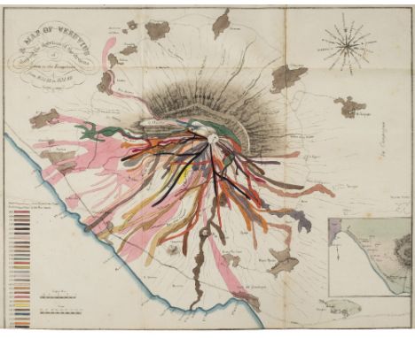
Auldjo (John). Sketches of Vesuvius, with Short Accounts of its Principal Eruptions, from the Commencement of the Christian Era to the Present Time, 1833, folding hand-coloured map (close-trimmed at foot with repaired tear to verso), 16 uncoloured lithographed plates, several folding, one or two closed tears, some light spotting and soiling, abrasions to front pastedown, contemporary boards, cloth reback, a few stains, 8vo (1)

Cary (John). Cary's Traveller's Companion or, a Delineation of the Turnpike Roads of England and Wales shewing the immediate route to every market and borough town throughout the Kingdom..., published John Cary, 1819, calligaphic title, advertisement and contents list, forty-three (complete as list) engraved maps with contemporary outline colouring, folding map of Yorkshire with old folds strengthened on verso, torn with slight loss to lower right corner, contemporary half calf, bumped and worn, 8vo Chubb. CCLXXXI. (1)
Borlase (William). The Natural History of Cornwall. The Air, Climate, Waters, Lakes, Sea and Tides; of the Stones, Semimetals, Metals, Tin, and the Manner of Mining... of the Inhabitants, their Manners, Customs, Plays or Interludes, Exercises, and Festivals; the Cornish Language, Trade, Tenures and Arts..., 1st edition, Oxford: Printed for the Author, by W. Jackson, 1758, folding engraved map, 28 engraved plates, occasional light spotting, armorial bookplate of Christopher Turnor, Stoke Rochford Library to upper pastedown, contemporary calf, rebacked preserving original gilt decorated spine panels and morocco title label, folio (1)
![*England & Wales. Mercator (Gerard), Anglia Regnum, [1595 or later], engraved map with contemporary outline colouring, 355 x](https://cdn.globalauctionplatform.com/a79f5b87-a33e-46b3-9885-a6fa00ae143d/a90555a6-a592-4dc3-c823-c82421f02772/468x382.jpg)

Johnston (Alexander Keith). Stanford's Library Map of Europe, constructed by A. Keith Johnston, Edward Stanford, June 1st, 1858, large-scale hand-coloured engraved map of Europe, sectionalised on linen, generally in very good, clean condition, overall size 1560 x 1730 mm (61.5 x 68 ins), loosely contained in publisher's cloth portfolio boards, rubbed and marked (spine cloth deficient), 4to A fine copy of the first of Stanford's series of library maps, later followed by Asia, Australasia, North America and Africa. (1)
![British Isles. Gastaldi (Giacomo), Angli e Hibernia Nova, published Venice [1548], uncoloured engraved map, two worm holes to](https://cdn.globalauctionplatform.com/a79f5b87-a33e-46b3-9885-a6fa00ae143d/eb4ddbc8-d8dd-4bb5-cc1d-3267935204b6/468x382.jpg)
Headrick (James). View of the Mineralogy, Agriculture, Manufactures and Fisheries of the Island of Arran. With Notices of Antquities, and Suggestions for Improving the Agriculture and Fisheries of the Highland and Isles of Scotland, 1st edition, Edinburgh, 1807, folding engraved map, light offsetting and a few spots, original boards, upper cover detached, spine defective, 8vo (1)
Mayo (John Horsley). Medals and Decorations Of The British Army And Navy, volumes 1 & 2, 1897, numerous colour plates, bookplates to front endpapers, some light spotting, uniform original red cloth, spines slightly toned and rubbed to head and foot, 8vo, together with Vaughn (E.L., editor), List of Etonians Who Fought in the Great War 1914-1919, privately printed, 1921, black and white title page, original quarter cloth to blue boards, slightly rubbed to head and foot, 4to, and Skirving (Edward Scot), Cheltenham College Register 1841-1927, Cheltenham, 1928, black and white folding map frontispiece, plus illustrations, previous owner's inscription to front endpaper, some slight toning, original gilt decorated black cloth, boards and spine slightly rubbed, 4to, plus other early 20th century military and school history and reltaed, including Army & Navy List, all original cloth, G/VG, 8vo/4to (6 shelves)

Kitchin (Thomas & Jefferys, Thomas). The Small English Atlas being a New and Accurate Sett of Maps of all the Counties in England and Wales, published Robert Sayer, John Bennett, John Bowles and Carrington Bowles, [1775], decorative calligraphic title, preface (with index and table of explanation on the same page), map of England & Wales and a map of the rivers of England, and forty-eight (complete) uncoloured engraved maps with descriptive text below image, slight finger soiling and staining largely confined to margins, later endpapers, modern quarter morocco, 4to The third edition has no date on the title page but must have been issued sometime after 1774 when Robert Sayer joined John Bennett in partnership. It is probably this edition that was advertised in the Sayer and Bennett catalogue of 1775. The maps differ from the earlier editions in that the borders of the hundreds, wapentakes and some canals and roads have been added and the list of towns below the maps is now alphabetical. Not in Chubb but c.f. Chubb CXCII for 1749 edition. (1)
[Vason, George]. An Authentic Narrative of Four Years' Residence at Tongataboo, one of the Friendly Islands, in the South-Sea, who went thither in the Duff, Under Captain Wilson, in 1796, 1st edition, 1810, engraved frontispiece and map (both laid down, some soiling and toning, recent half calf gilt, 8vo, together with Big Game and Pygmies. Experiences of a Naturalist in Central African Forests in Quest of the Okapi, by Cuthbert Christy, 1st edition, 1924, folding map, half-tone illustrations, a little light spotting, original blue cloth gilt, some fading to spine, 8vo, plus The River and the Desart: Or, Recollections of the Rhone and the Chartreuse, by Miss Pardoe, 2 volumes, 1st edition, 1838, lithographed frontispieces (one with light water stain), light toning, shelf labels, contemporary half calf, Society of Writers to the Signet gilt stamps to covers, joints cracked with losses to spines, 8vo, with others including Travels in Istria and Dalmatia, Drawn up from the Itinerary of L.F. Cassas, by Joseph Lavallee, 1805, Charles Rothery's Notes on a Yacht Voyage to Hardanger Fjord, and Adjacent Estuaries, circa 1850 and Henry Blackburn's The Pyrenees: A Description of Summer Life at French Watering Places, 1867 (35)
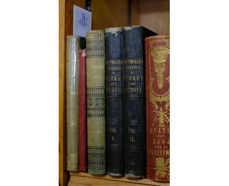
Curzon (Robert). Armenia: A Year at Erzeroom, and on the Frontiers of Russia, Turkey, and Persia, 1st US edition, Harper & Brothers, New York, 1854, map and wood-engraved illustrations, a little light spotting and toning, a few creases, library ink stamp and marks to front pastedown, original cloth, some fading, 8vo, together with A Diary in the Dardanelles, Written on Board the Schooner "Corsair," whilst beating through the Straits, from Tenedos to Marmora, by William Knight, 1st edition, 1849, map frontispiece, one or two leaves trimmed at fore edge, front hinge breaking, original red cloth, spine a little rubbed with tear at head, 8vo, plus A Tarantasse Journey through Eastern Russia in the Autumn of 1856, by William Spottiswoode, 1st edition, 1857, folding map, seven tinted lithographed plates, including one folding, some light spotting and marginal ink stains, endpapers renewed, original cloth, rebacked with original spine relaid (faded), 8vo, with two others: Horatio Southgate's Narrative of a Tour through Armenia, Kurdistan, Persia, and Mesopotamia, 2 volumes, 1840 and S.S. Hill's The Dominions of the Pope and the Sultan, circa 1850 (6)
*Penbroke & Caermarthanshire. Blaeu (Johannes), Penbrochia comitatus et comitatus Caermardiunum, circa 1645, engraved map with contemporary hand colouring, 415 x 540 mm, Dutch text on verso, together with another copy with some spotting and staining, mounted, framed and glazed, with Saxton (Christopher & Hole William), Glamorgan comitatus qui olim pars Silurum, [1607], hand coloured enrgaved map, strapwork cartouche and mileage scale, slight text showthrough, 275 x 335 mm, mounted, framed and glazed (3)
Rogers (Samuel). Italy, A Poem, 1830, black and white illustrations, book plate and period inscription to front endpaper, some light spotting and offsetting, contemporary gilt decorated full morocco, boards and spine slightly rubbed, 8vo, together with Dickens (Charles), The Posthumous Papers of The Pickwick Club, 1842, 43 black and white illustrations by Phiz, some light spotting and marks, rebound retaining contemporary green half calf boards and gilt decorated spine, slightly rubbed 8vo, and Brassey (Annie Allnutt), Sunshine and Storm in the East, or Cruises to Cyprus and Constantinople, 1880, numerous black and white illustrations, plus colour folding map frontispiece, cracked front guttering, some minor spotting, all edges gilt, contemporary gilt decorated red full calf, boards and spine rubbed with slight loss, 8vo, plus other 19th century literature and reference, all gilt decorated leather bindings, condition is generally good/very good, 8vo, approximately 80 volumes in total (3 shelves)
Bannerman (David Armitage). The Birds of Tropical West Africa. With Special Reference to those of the Gambia, Sierra Leone, The Gold Coast and Nigeria, 8 volumes, 1st editions, 1930 - 1951, numerous colour chromolithographic and black and white plates, folding map to volume one, top edge gilt, remainder untrimmed, dust jackets a little frayed and dust soiled, publisher's blue cloth gilt, 4to, together with Thorburn (Archibald),British Birds, 4 volumes, volumes 1 & 2, 4th edition, volumes 3 & 4 third edition, 1918, additional half titles, eighty-two (complete) colour plates, each with tissue guard, top edge gilt, publisher's red cloth gilt, spines faded, a little worn and frayed at head and foot of spines, boards a little stained and marked, folio (12)
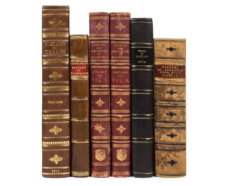
Whitaker (Thomas Dunham). The History and Antiquities of the Deanery of Craven, in the County of York, 2nd edition, 1812, engraved portrait frontispiece, tinted etched title page, engraved folding map, fifty engraved plates (including twenty-four sepia aquatints, most after Alken, and one hand-coloured plate), numerous folding pedigrees, offsetting from plates, spotting generally restricted to two sections (Ii and 3G), three or four leaves with short closed tears to blank margins, new endpapers, contemporary half calf, rebacked, marbled sides a little rubbed, large 4to, together with Hinderwell (Thomas), The History and Antiquities of Scarborough and the Vicinity: with Views and Plans, 1st edition, York: William Blanchard, 1798, engraved frontispiece and three other plates, two folding maps, subscribers list, three additional uncalled for plates, including a double-page panorama of Scarborough dated 1869, and two rare portraits of 'Dicky' Dickinson, Governor of the Spaw (inserted between pp.174-175), scattered spotting, offsetting from plates and maps, embossed library stamps to title, panorama and to blank margins of Dickinson portraits, contemporary ink ownership inscription to title, front pastedown with early ink annotation and armorial bookplate of James Comerford, original boards rebacked and recovered (original endpapers reused), 4to in 2s, plus Poulson (George), The History and Antiquities of the Seigniory of Holderness..., two volumes, Hull, 1840, engraved maps and plates, occasional spotting, mainly to first and last leaves, marbled endpapers, front pastedown with armorial bookplate of William Garnett Esq. of Bleasdale and Quernmore Park, Co. Lancaster, contemporary half morocco gilt, rubbed and a trifle worn, plus The History of Cleveland, by Rev. John Graves, 1808, and The History of the Town and County of Kingston Upon Hull, by Rev. John Tickell, 1796 Second title: James Comerford (1807-1881) was an antiquary, notary, and book collector. After his death his large library, particularly rich in topography, was sold at Sotheby's in 1881. The family motto on his heraldic bookplate, 'So ho ho dea ne', defies translation but may derive from an old Norman-French hunting call. (6)

Canary Islands. Coronelli (Vicenzo Maria), Isole Canarie, published Venice, c.1695, uncoloured engraved map, decorative cartouche and mileage scale, inset 'fringed curtain' containing a map of the island of Madiera and the port of Funchal, compass rose and numerous rhumb lines, slight creasing and occasional marginal closed tears, some dust soiling to upper right corner largely confined to margins, 455 x 605 mm (1)
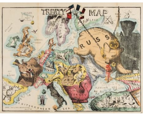
Europe. Onwhyn (Tom), Treaty Map, published Rock Brothers & Payne, April 20th, 1856, etched allegorical map with contemporary hand colouring, old folds, two small marginal closed tears, retaining pictorial paper wrappers with description key to verso of upper cover, upper cover detached, covers a little soiled and frayed, 485 x 620 mm Rare anamorphic map celebrating the Treaty of Paris which was signed on 30th March 1856 and which formally ended the Crimean War. The Russian Bear lifts its paw (which is streaming with blood) away from the Crimean peninsula. The bear's body is covered with the words 'tyrrany', 'oppression', 'treachery', 'bigotry' and 'ignorance'. However along its back is the notice 'Russian hide, wants more tanning'. Onwhyn clearly thinks little of the treaty as he shows Britannia's sword bound with 'red tape' and her lion with an eye-patch. Other European countries fare little better. Italy is depicted as a mad dog in convulsions, being strangled by a collar labelled 'popery'. Poland is depicted as a gravestone with 'Defunct nationality' engraved upon it and Austria is a double headed ass. Prussia is an obeisant cur wearing the collar of the Czar with the 'Very Petty German states' tied to its tail.The map appears to be a follow on from Onwhyn's 1854 map 'Comic Map of the Seat of the War' which was copied and also published in Belgium by Louis Mols-Marchal. Rod Barron in his blog of June 9th 2015 ;Clipping the Russian Bear's claws...,' describes the 1854 map and describes how, as the war progressed and casualties mounted that sentiment turned against treating the war as a subject for mirth and satire. It is perhaps surprising that Rock Brothers and Payne thought it appropriate to issue another map after what must have been considerable public opprobium. This may also explain why we have been unable to find a copy of this map appearing in auction or being held by an insitution. (1)

Crete. Coronelli (Vicenzo Maria), Isola e Regno di Candia, published Venice, circa 1695, large uncoloured engraved map on two sheets (as published), elaborate floral border with medallions containing the names of 100 towns and cities, slight browning to central folds, slight worming to margins, each sheet approximately 455 x 620 mm, Italian text on verso (2)
Higgins (Godfrey). The Celtic Druids; or, An Attempt to Shew, that the Druids were the Priest of Oriental Colonies who Emigrated from India..., 1829, additional lithographed vignette title, single-page map and 46 plates and plans (including 4 double-page), 7 lithographic illustrations, all on india paper, a few woodcut vignette illustrations to text, some heavy spotting, mainly affecting plate leaves, scattered browning, old closed tear repairs to inner and lower margins of printed title and new preface leaf, armorial bookplate of Randall Hatfeild to front pastedown, uncut with wide margins (?large paper copy), modern tan brown morocco, spine lettered in gilt, a little rubbed and bumped at extremities, 4to (32 x 25 cm) (1)


England & Wales. Walker (J. & C.), A Geological Map of England & Wales showing also the Inland Navigation by means of Rivers and Canals with their Elevation in feet above the Sea, together with the Rail Roads and principal Roads, published J & C Walker, 1835, large engraved map with contemporary hand colouring, sectionalised and laid on linen, calligraphic title, table of explanation with a geological and mineralogical cross section below map, slight staining and offsetting, cloth endpapers with a book plate of J.C.Thackray, 1260 x 980 mm, contained in a contemporary cloth slipcase worn and frayed with 'envelope style' flap detached Some of the railways highlighted on the map were constructed after 1835 which would indicate that the colouring for the railways is slightly later than the published date. (1)

Johnston (Alexander Keith). The Physical Atlas of Natural Phenomena, published William Blackwood and Sons, Edinburgh and London, 1850, printed title, frontspiece of a double page palaeontological map of the British Isles, twenty-four (complete as list), engraved maps with contemporary outline colouring, slight marginal spotting and finger soiling, all edges gilt, contemporary gilt panelled and decorated dark maroon morocco, spine a little faded, minor rubbing to extremities, folio (1)
[Serao, Francesco]. The Natural History of Mount Vesuvius, with the Explanation of the various Phenomena that usually attend the Eruptions of this celebrated Volcano. Translated from the Original Italian, composed by the Royal Academy of Science at Naples, by Order of the King of Two Sicilies, 1st English edition, London: E. Cave, 1743, two folding woodcut plates (one lined to verso & with closed tear to central fold), folding table, blind library stamp to title plates, few other leaves & free endpapers, ink library stamp to verso of title, occasional scattered spotting, ownership signature of John Wickins 1744 to front free endpaper, later quarter sheep, joints cracked, spine worn, 12mo in 6s, together with Winchilsea (Heneage Finch, 2nd Earl of), [A True and Exact Relation of the Late Prodigious Earthquake & Eruption of Mount Aetna, or, Mount-Gibello; as it came in a Letter Written to His Majesty from Naples by the Right Honorable The Earle of Winchilsea, His Majesties late Ambassador at Constantinople, who in his Return from thence, Visiting Catania in the Island of Sicily, was an Ey-witness of that Dreadfull Spectacle. Together with a more particular Narrative of the same, as it is collected out of severall relations sent from Catania, Printed by T. Newcomb, 1669], folding engraved frontispiece present with few repairs to edges (dust-soiled and dampstained, old ink stamp to verso of Royal Meteorological Society, Symons Bequest), facsimile title and final leaf, first & last leaf repaired at gutter margin, spotting and dust-soiling, early 20th century wrappers with manuscript title and ink stamp to upper cover, slim 8vo, contained in modern portfolio, plus Hamilton (William), Observations on Mount Vesuvius, Mount Etna, and Other Volcanos: In a Series of Letters Addressed to the Royal Society, 2nd edition, 1773, five engraved plates and one folding map, contemporary half calf, rebacked preserving original spine, 8vo, plus four 18th century disbound pamphlets (one defective), including A Sermon on the Late Earthquakes, More particularly that at Lisbon..., by Thomas Alcock, Oxford, 1756 (7)
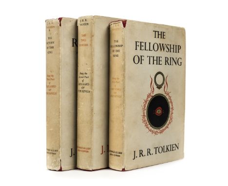
Tolkien (J.R.R.). The Fellowship of the Ring, 2nd impression, 1954; The Two Towers, 1st edition, 1954; The Return of the King, 1st edition, 1955, folding map at end of each, light spotting front and rear, previous owner inscription to Fellowship, original red cloth, dust jackets, some fading to spines, a few tears, chips and stains, 8vo (3)

Lancashire. Blaeu (Johannes), Lancastria palatinatus Anglis Lancaster et Lancashire, published Amsterdam, circa 1648, hand coloured engraved map, 400 x 510 mm, Latin text on verso, together with Cumbria vulgo Cumberland, published Amsterdam, circa 1646, engraved map with contemporary hand colouring, large decorative cartouche and mileage scale, 415 x 505 mm, Dutch text on verso (2)

Gordon (Patrick). Geography Anatomiz'd: or, The Geographical Grammar. Being a short and exact analysis of the whole body of modern geography, after a new and curious method, Seventeenth edition, corrected, and somewhat enlarged; and a set of new maps, by Mr. Senex, 1741, half-title, title printed in red and black, folding map of the world, and 16 folding engraved maps by Senex, including Asia, Africa, North America and South America, contemporary blind-panelled calf, spine label loosely inserted at front of volume, a little rubbed and upper joint partly cracked, a very good clean copy, together with a defective copy of William Salmons's Geographical and Astronomical Grammar, mid-18th century, with 16 folding maps, some tears, soiling and defects, contemporary calf, some wear, both 8vo (sold with all faults) (2)
Mawe (John). The Mineralogy of Derbyshire: with a Description of the most Interesting Mines in the North of England, in Scotland, and in Wales; and an Analysis of Mr. William's Work, Intitled "The Mineral Kingdom", Subjoined is a Glossary of the Terms and Phrases used by Miners in Derbyshire, 1802, three engraved plates (including frontispiece) and single-page map, edges untrimmed, original boards, printed title label to spine, loss at head & foot of spine and some wear, 8vo, together with Sopwith (T., land & mine surveyor), An Account of the Mining Districts of Alston Moor, Weardale, and Teesdale, in Cumberland and Durham; comprising Descriptive Sketches of the Scenery, Antiquities, Geology, and Mining Operations, in the Upper Dales of the Rivers Tyne, Wear, and Tees, Alnwick: Printed by and for W. Davison, 1833, hand-coloured engraved map frontispiece (lightly offset to title), scattered spotting, original cloth, neatly rebacked preserving original printed title label, some fading to boards, 8vo, with Forster (Westgarth), A Treatise on a Section of the Strata, from Newcastle Upon Tyne, to the Mountain of Cross Fell, in Cumberland; with Remarks on Mineral Veins in General. Also, Tables of the Strata, in Yorkshire, Derbyshire, &c., To which is added, a Treatise on the Discovery, the Opening, and the Working of Lead Mines; with the Dressing and Smelting of Lead Ores, 2nd edition, greatly enlarged, Alston, Cumberland: Printed for the Author by John Pattinson, 1821, ink initial stamp to title, eleven plates (4 hand-coloured, some folding, plates 1, 2 & 11 not published), folding table, wood engraved diagrams & illustrations to text, endpapers renewed, contemporary half calf, rebacked, 8vo, plus Werner (Abraham Gottlob), New Theory of the Formation of Veins; with its Application to the Art of Working Mines..., Translated from the German, to which added, containing notes illustrative of the subject by Charles Anderson, 1st English Edition, Edinburgh: Printed at the Encyclopaedia Britannica Press for Archibald Constable & Co., 1809, half-title, lacking portrait frontispiece, edges untrimmed, original boards, repair to upper joint, wear to spine & upper joint, 8vo (4)
Brecknockshire. Speed (John), Breknoke both Shyre and Towne described, published John Sudbury and George Humble, circa 1627, uncoloured engraved map, inset town plan of Brecknock, 385 x 515 mm, English text on verso, together with Kitchin (Thomas), An Accurate Map of Brecknockshire drawn from an actual Survey with various improvements..., published R.Wilkinson, Laurie & Whittle and Bowles and Carver, circa 1785, uncoloured engraved map, trimmed to neatline along upper border, margin replaced, 350 x 530 mm (2)
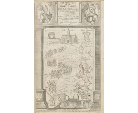
Fuller (Thomas). The Holy State, & The Profane State, 3rd edition, printed by R.D. for John Williams, 1652, title to each part, with woodcut vignette of a crown, and woodcut border to each, additional engraved title to first part, 20 engraved portraits to text, with fore-margin partially excised, upper outer corner and inner margin restrengthened, several engraved portraits to text, bound with The Historie of the Holy Warre, 3rd edition, Cambridge, Roger Daniel, 1647, additional engraved title, folding engraved map of the Holy Land, early ownership inscriptions of Henry Montfort at head of title, and 'William Williams His Booke 1692' to foot of main title, 19th century bookplate of John Russell to front pastedown, near-contemporary calf-backed boards, heavily rubbed and some wear, with joints partly cracked, folio (1)
![Netherlands. Blaeu (Johannes), Hollandiae pars septentrionalis vulgo Westuriesland en 't Noorder quartier [and] Ultraiectum d](https://cdn.globalauctionplatform.com/a79f5b87-a33e-46b3-9885-a6fa00ae143d/c145b3e9-8476-4884-fa0d-05cb43ddc236/468x382.jpg)
Netherlands. Blaeu (Johannes), Hollandiae pars septentrionalis vulgo Westuriesland en 't Noorder quartier [and] Ultraiectum dominium, published Amsterdam, circa 1643, two engraved maps with contemporary outline colouring, the first map orientated to the west, each approximately 390 x 500 mm, Latin text on verso (2)
*Monmouthshire. Speed (John), The Countye of Monmouth with the sittuation of the shire towne described, published Thomas Bassett & Richard Chiswell, [1676], hand coloured engraved map, inset town plan of Monmouth, large strapwork cartouche and mileage scale, slight creasing, central fold strengthened on verso, 385 x 510 mm, English text on verso, mounted, framed and double glazed, together with Blome (Richard), A Mapp of ye County of Mounmouthshire, [1673], hand coloured engraved map, slight spotting to margins, 315 x 245 mm, mounted, framed and glazed (2)

Yorkshire. Dix (Thomas), A New Map of the County of York, divided into its Ridings with their Subdivisions, Exhibiting the whole of the Mail, Direct and Principal Cross Roads, Navigable Canals, Rivers &c &c, published William Darton, 1820, engraved map with contemporary outline colouring, circular cartouche, uncoloured engraved vignette of 'South East View of York', table of explanation, list of market towns and their market days and a list of Wapontakes, old folds, backed with archival tissue and folds strengthened, 580 x 710 mm, together with Smith (T.M., Darton, Thomas, & Clark William), Yorkshire divided into its Ridings with their subdivisions, exhibiting the whole of the Mail, Direct and Principal Cross Roads, Rivers, Navigable Canals, Railways and the Parliamentary Divisions, published Darton & Clark, 1845, engraved map with contemporary outline colouring, hand coloured engraved vignette of the South East View of York, list of market towns and their market days and a list of the Wapontakes, some staining and slight offsetting, old folds, repaired closed tear and central fold repaired on verso, 580 x 710 mm Both maps are scarce with the second described map apparantly unrecorded. (2)
-
109182 item(s)/page