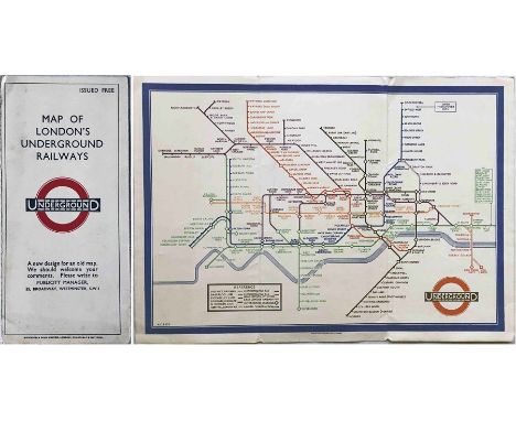
We found 109198 price guide item(s) matching your search

Refine your search

Year

Filter by Price Range
  • List
  • Grid
  • 109198 item(s)
    /page

Lot 218

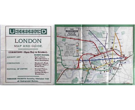
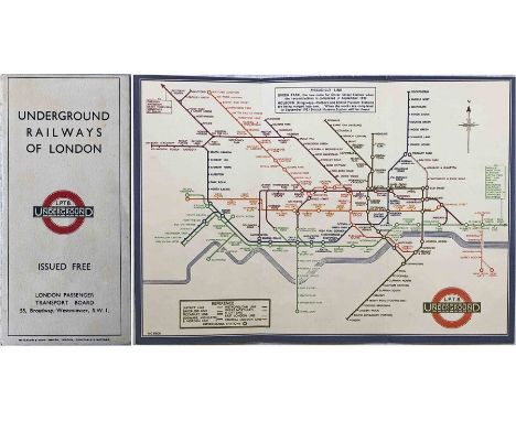
1921 London Underground POSTER MAP, print-code 358-1000-9/6/21. Shows the Hampstead line extension beyond Golders Green as under construction. Also shows motor-bus connections. Measures 30" x 24" (76cm x 61cm) and is in generally very good condition with just a few age-related blemishes. Folded. [1]

Lot 224

c1910-15 'Great Central Railway and its Connections' MAP (paper) with an inset enlarged scale map of central England. Strong, vibrant colours make this a very attractive map. Measures 26" x 39" (66cm x 100cm). Some small blemishes but generally in very good condition. Folded. [1]

Lot 502

1908 London Underground POCKET MAP showing the exhibition venues at Shepherd's Bush & Earl's Court. 1908 saw the first use of the UndergrounD logo as a header on these maps. This is a special edition produced for the Midland Railway whose information appears on 2 panels on the reverse. In used condition with some short partings at the folds but presents very well overall. [1]

Lot 208

Selection (3) of Underground Group/London Transport POSTERS etc comprising 1921 MAP of General Motor-Bus Routes (edge-scuffs, small tears but generally good) (very detailed, hand-drawn map of East Kent routes on reverse) and 1934 (1936 reprint) Trolleybus & Tram MAP bearing the legend 'Trolleybuses now operate on certain of the tram routes shown on this map' (generally good) (both approx 34" x 26", 86cm x 66cm) plus a 1933 DIAGRAM of 'Lines run over by Metropolitan Line Trains' (39" x 26", 99cm x 66cm) (short tear, otherwise good). [3]

Lot 225

1930s FLYING EPHEMERA comprising a 1932 AA Aviation Department FLYING MAP for the route from Biarritz to Bordeaux, produced for W L Hey, plane reg G - ABLR (1931 de Havilland Puss Moth). Printed on stiff, waterproof paper inside board covers with additional information about the aerodromes. Opens out to 41" x 10" (104cm x 25cm), in excellent condition. Plus an RAS (Railway Air Services) MAP OF AIR ROUTES, paper inside card covers, opens out to 29" x 12" (74cm x 31cm), in good condition. [2]

Lot 393

1933 first edition of the H.C. Beck London Underground diagrammatic card POCKET MAP with the famous cover slogan "A new design for an old map." A lightly-used example with a little wear but generally in good to very good, unmarked condition. [1]

Lot 284

c1912-17 Bacon's 'Portable Railway, Tramway & Underground Railway MAP of London'. Opens out to 30" x 20" (76cm x 51cm). Art-Nouveau-style cover design with illustrations of a steam-hauled train, tram and sub-surface and tube trains. Reverse is printed with 'Stranger's Guide to London'. Undated but CLR extension to Liverpool St is open (1912) and GWR/CLR line from Ealing to Wood Lane is under construction (opened 1917). Map is in excellent condition, cover has some wear/repair. [1]

Lot 214

c1932 London Underground quad-royal POSTER MAP designed by G W Bacon & Co. Lines are shown in colour superimposed on a street map of London, stations are depicted in 'bar & circle' format. A box in the upper margin states that the Piccadilly Railway extension to Southgate is under construction. Some short fold-partings reinforced on the reverse, otherwise in good condition. Folded [1]

Lot 135

Early 1920s Metropolitan Railway MAP 'Extension Lines into Metro-Land' produced as part of the Met's push to develop what it termed Metro-Land. Shows the new estates being developed along the line as well as golf-courses. The reverse is a general map of the Underground system with the Met highlighted in red. Folded, opens out to 19.5" x 15.5" (49cm x 40cm). In very good, lightly-used condition. [1]

Lot 426

Selection (21) of London Transport bus-related POSTERS comprising 1946 'Courtesy Aids Service' (20" x 25" - 51cm x 62cm), 1932 'General' map (33.5" x 25.5" - 85cm x 65cm, rather tatty), 3 x quad-royal bus maps (1962 & 2 x 1975) plus 16 x 1970s/80s interior posters to fit RTs, Routemasters. Generally in good condition, some blemishes to the large posters which are folded. [21]

Lot 352

1923 London Underground MAP of the Electric Railways of London "What to see and how to travel". Designed by MacDonald Gill with his distinctive style of calligraphy and map border, this is the issue dated 1/1/23 and the version thereof which shows the British Empire Exhibition stations with red dots. A very good example. [1]

Lot 252

1921 and 1925 editions of "METRO-LAND" BOOKLET published by the Metropolitan Railway. The first has some wear, loose cover, no fold-out map and the second also has some wear, spine reinforced, but is complete with the original fold-out map of 'Extension Lines into Metro-Land' on one side and the central section of the Metropolitan Railway, rest of the Underground and other railways on the reverse. The map is in very good condition. [2]

Lot 433

1911 London Underground POCKET MAP. This edition shows the 3 separate Hammersmith stations, the CLR extension to Liverpool St under construction and the LBSCR lines to Crystal Palace. Opens out to 10.5" x 8" (27cm x 20cm). In very good, lightly-used condition, a very small printing smudge at the bottom edge and a short inward tear from the r/h edge. An ex-guidebook copy that has been re-folded. [1]

Lot 323

1922 London Underground MAP OF THE ELECTRIC RAILWAYS OF LONDON 'What to See & How to Travel' with issue date 1-3-22. Designed by MacDonald Gill with calligraphed station names, the map opens out to 13.5" x 11" (34 x 28cm). A good copy, lightly used with '1923' written on cover and a partial parting of the centrefold. [1]

Lot 453

1912 London Underground POCKET MAP "What to See and How to See it" printed by George Philip & Son Ltd and featuring the vertical UndergrounD logo. This issue marks stations with black-outlined white circles and shows the Met station as Hammersmith (Grove). The reverse shows a theatre plan, places of amusement etc. Opens out to 10.5" x 8" (27cm x 20cm). A very good copy indeed, just a small printing smudge at the top r/h corner and a few other minor blemishes but generally an excellent example. [1]

Lot 221

1967 London Underground quad-royal POSTER MAP designed by Paul E Garbutt. Print-code 467/1164Z/2500. Shows the Victoria Line under construction. A few minor blemishes but generally very good. Previously folded. [1]

Lot 11

1947 quad-royal POSTER MAP 'London & Suburbs, Main Line Railways and connecting Underground Railways of the London Passenger Transport Board'. Probably the last, pre-nationalisation example of this map, published jointly by the main-line railways, later examples were issued by the British Transport Commission. A very detailed, interesting map with many now-closed lines and stations. A few edge-scuffs and small fold-corner partings but generally a very good copy. Previously folded. [1]

Lot 126

LCC Tramways GUIDEBOOKS comprising 1911 'Official Tramways Guide (186pp + fold-out map) plus 2 issues of 1931 'Round and About London by Tram' for North and South of the Thames respectively (158pp & 134pp, each with a fold-out copy of the Nov 1931 Tramways Map). Some cover wear but generally in very good condition. [3]

Lot 259

1930s CIGARETTE CASE with engraved London Underground map including pre-WW2 bullseye logo. Undated but map shows Underground service on the West London line which ceased during WW2. Manufactured by Tallent in silver and gold-coloured metal with two spring-loaded cigarette compartments. In very good condition. [1]

Lot 477

1924 (1st edition) of Geographia 'AUTHENTIC MAP DIRECTORY OF LONDON & SUBURBS' (worn covers, repairs to spine) plus a quantity of London-related books, booklets, maps & guides etc incl 1895 City of London Directory, LCC Reports 1907-8, LCC London Statistics 1936-38, hard-cover London Atlases and a great variety of other publications. [Quantity]

Lot 471

Selection (4) of 19th-century London MAPS comprising 1833 James Wyld's Map of the Vicinity of London (sectioned on card-backed pages) plus linen-backed fold-out maps inside hard covers: 1861 Ordnance Survey 1" London & Environs, 1863 Davies' Map of the Environs of London and 1871 Collins' Standard Map of London. All are in generally good, used condition with varying degrees of wear. [4]

Lot 418

Pair of 1924 & 1925 British Empire Exhibition at Wembley official, fold-out GUIDES, the first with a map designed by Kennedy North in a style similar to MacDonald Gill with an Underground map with calligraphed station names and elaborate, colourful illustrations. Used with some cover wear but are good when opened out. [2]

Lot 227

1927 'Stingemore' London Underground linen-card POCKET MAP, the issue dated January 1927. This is a special edition produced for Sun Insurance and is overprinted with their information on the cover and map. In used condition with some wear, a horizontal crease and age-spotting etc but overall still good. [1]

Lot 165

1927 MAP of the Railway Systems in India, Burma and Ceylon. Published by the Calcutta Chromotype Co. Opens out to 44" x 40" (112cm x 102cm), a very detailed map that also shows Malaya and includes 10 area inset maps, distance charts, index of railway systems & companies, lines under construction etc. In good condition, some strengthening applied to the reverse. [1]

Lot 485

1915 Railway Clearing House 'OFFICIAL RAILWAY JUNCTION DIAGRAMS', 158 coloured diagrams + index & supplements, inside hard covers, plus 1921 edition of RCH Official RAILWAY MAP of London & Environs, fold-out, linen-backed, inside hard covers, plus 1900 issue of Met & G C Joint Committee Cartage Area MAP for Gt Missenden, fold out, linen-backed, inside hard covers. All are in good to very good, used condition, the first has some cover wear. [3]

Lot 204

1979-84 London Underground quad-royal POSTER MAP designed by Paul E Garbutt. Shows the original Jubilee line to Charing Cross and the Piccadilly line to Heathrow Central. It also now incorporates BR's North London line. Undated but must be 1979-84 period. A few minor blemishes but generally in very good condition. [1]

Lot 6

LCC Tramways POCKET MAP & GUIDE, December 1913 issue with a cover illustration of a single-deck car emerging onto the Embankment from the Kingsway subway. In very good condition, a little age-darkened. [1]

Lot 486

1912 (June-Sept) London, Tilbury & Southend Railway TIMETABLES with cover illustration of Southend-on-Sea and fold out map of the line & connections plus 1914 Great Central Railway APPENDIX to the WORKING TIMETABLE from Oct 1st. Both have been bound into hard covers, the former is in very good condition, the latter has a repaired first page, otherwise good. [1]

Lot 281

1925 London Underground MAP of the Electric Railways of London "What to see and how to travel", Summer 1925 edition. In very good condition, an excellent example. [1]

Lot 253

1865 MAP 'A new Map of Metropolitan Railways & Miscellaneous Improvements. Deposited at the Private Bill Office, November 30 1865 for [Parliamentary] Session 1866'. Linen-backed inside original leathercloth covers, opens out to 33" x 34" (84cm x 869cm). In very good condition. [1]

Lot 85

c1930-50s enamel BOOKING OFFICE SIGN for Royal Blue Express Coach Services incorporating a network map. A superbly detailed and colourful sign measuring 20" x 30" (51cm x 76cm). Original wooden backing frame is partially present. In very good, ex-use condition, would benefit from a thorough clean. [1]

Lot 238

Large quantity (c80) of London Transport Green Line Coaches TIMETABLE LEAFLETS for individual routes from 1934-1947 plus a Green Line MAP from 1933 (33-3630, 20000). Generally in good to very good condition. [c80]

Lot 207

1930s Great Western Railway (GWR) quad-royal POSTER 'The Cambrian Coast & Dee Valley - a paradise for the tourist, the sportsman and the antiquary' by J P Sayer. A detailed, pictorial map of the region showing major sights, narrow-gauge railways etc. In rather fragile condition with some tears, small losses, worn folds, edge-scuffs etc but can still present well. [1]

Lot 198

1928 London Underground POCKET MAP of the Electric Railways of London "What to see and how to travel". Summer 1928 edition, designed by E G Perman with elaborate calligraphy of station names and border etc. In very good condition, an excellent example. [1]

Lot 296

1947 London Underground quad-royal POSTER MAP by H C Beck 'London's Underground', still in the pre-war style with elaborate border designed by 'Shep' (Charles Shepard). Print-code 547/1071M/2000. Shows the planned extensions of the Central Line to Ongar and West Ruislip and the subsequently abandoned Northern Line ones to Alexandra Palace, Mill Hill (The Hale) and Bushey Heath. Beck has thickened the lines to allow the line names to be included within them. Age-darkened, some damp staining, losses at edges, heavily folded. [1]

Lot 57

Selection (7) of Southern Railway etc original and reprinted CARRIAGE MAPS of which unframed (all folded) are: c1904-08 South Eastern & Chatham Railway on paper (damp-stained & nibbled edges, small loss at edge), Southern Railway c1924-24 and c1926-27 'Road to Sunshine' (both on card) plus similar to latter (reprint) plus framed & glazed (all reprints): LBSCR 'Sunny South Coast & Isle of Wight', SR 'Island & Mainland Connections' and SR General System Map, all in good condition. [7]

Lot 283

1910 MAP of the London & North Eastern Railway & Connections [North Eastern Area] with a key to 20 railway companies, the region's natural products, principal industries, fishing ports & imports. Linen-backed inside board covers, opens out to 34.5" x 44.5" (88cm x 113cm). Map is in very good condition, covers are a little worn, spine has been replaced. [1]

Lot 195

Quantity (27) of 1920s-onwards LCC Tramways, LGOC, LUT, London Transport POCKET MAPS & LEAFLETS incl 9 LGOC bus maps, 1-2-3 Bus, Tram & Tube Guide (c1920), 2 LUT Trams leaflets, 7 LCCT leaflets etc, 8 LT leaflets (incl Underground extensions) plus a quantity (55+) of London Transport bus & coach pocket map AMENDMENT LEAFLETS dated from 1950-69. Condition ranges from lightly-used to very good. [80+ items]

Lot 118

1884 SPECIAL REPORT from the [Parliamentary] Select Committee on the Metropolitan Railway (Park Railway & Parliament St Improvement) Bill. 527 pages inside new soft-card covers, printed by Hansard, includes fold-out map of central London railways incl early underground lines and planned pneumatic and 'Paxton' lines plus another of omnibus routes. An interesting and important historical document. [1]

Lot 233

Selection (6) of 1927-58 London Underground POCKET MAPS comprising June 1927 'Stingemore' (small foxing stains, otherwise very good), c1932 Metropolitan Railway M.1795/50M (good condition), Railway Map No 1, 1937 (good) and Beck diagrams No 1, 1948, Jan 1951 & 1958 858 (lightly used). Plus 3 x 1924/25 Underground Group PAMPHLETS for Wembley Exhibition etc (lightly used). [9]

Lot 128

1907 "District" [Railway] MAP of Greater London & Environs, 2nd edition. Shows the Franco-British Exhibition (held in 1908). A large-scale, full-colour map (42" x 26", 107cm x 66cm), linen-backed and folded into hard covers. Bakerloo, Hampstead & Piccadilly tubes shown in bold, non-Group tubes, eg Central and C&SLR, not so prominently! Map is in very good condition, the usual wear to the covers, the front cover is detached. [1]

Lot 206

1927 London Underground quad-royal POSTER MAP, print-code 694/4000/24-5-27. Shows the lines in full colours in 'Stingemore' style (no designer credited) superimposed on a street map and with a deep-blue border. Bears a small stamp of the LNER Advertising Department in the index section. Some small edge-losses, some folds are fragile and reinforced on the reverse but generally a good example. Folded. [1]

Lot 509

c1950-60s enamel BOOKING OFFICE SIGN for Royal Blue Express Coach Services incorporating a network map in the top half. A superbly detailed and colourful sign measuring 20" x 30" (51cm x 76cm). Original wooden backing frame is present. In excellent, ex-use condition with a good shine. [1]

Lot 137

Pair of matching April 1914 bus and tram POCKET MAPS comprising London General Omnibus Company Map & Guide and LCC Tramways Map & Guide. The former is a little worn but generally good, the latter is in very good condition. [2]

Lot 203

1965 British Rail quad-royal POSTER MAP of Greater London Network in diagrammatic format, designed by D J Lowten. Features a very early depiction of the then new BR logo and shows the lines in colour by section. Includes several since-closed lines and stations, eg Holborn Viaduct, Addiscombe, Forest Row etc. A short inward tear at one fold, a few minor blemishes but generally very good. Folded. [1]

Lot 331

1933 London Underground H C Beck diagrammatic, card POCKET MAP from the first-year series titled 'Underground Railways of London'. This is the edition with no print-code, issued c. August 1933 and has 'LPTB' inside the bullseye logos. Refers to re-naming of Dover St station to Green Park and the merger of Holborn and British Museum stations, all in September that year. In very good condition, an excellent example. [1]

Lot 211

1955 London Underground quad-royal POSTER MAP designed by H C Beck. Shows the network in its settled post-war state and utilises the wider lines to allow for the line names to be shown on them. An excellent example in very good condition. Folded. [1]

Lot 1065

Gerard Mercator (Flemish 1512-1594): 'Anglia regum', 16th century map with hand colouring, pub. Rumold Mercator Amsterdam 36cm x 48cm

Lot 753

A folding Philips wall map of Surrey 1950's (175cm x 125cm)

Lot 188

Edinburgh Map in a glazed frame in a vignette of Edinburgh Castle, 68 x 53cm

Lot 116

S Pyle 18th Century Double Sided Coloured Engraved Map of the road from Perth to Brechine, and the road from Braemarr to Fort George, published 1776, 47cm x 18cm, framed

Lot 132

In the Manner of Herman Moll, World map, 16cm x 30cm, later mounted and framed

Lot 1038

SCHENK (PIETER & VALK GERARD), LANCASTRIA PALATINATUS ANGLIS LANCASTER AND LANCAS SHIRE, hand-coloured engraved map, framed. Plate 38cm by 50.5cm

Lot 1039

SPEEDE (JOHN) [SPEED], THE PROVINCE OF CONNAUGH WITH THE CITIE OF GALWAYE DESCRIBED, 1610, Sudbury and Humble uncoloured map, latin text to rear, framed. Plate 38.5cm by 51.5cm

Lot 1037

BOWEN (EMANUEL), CHESHIRE DIVIDED INTO ITS HUNDREDS, c.1756, hand-coloured engraved half sheet map, framed; together with ANOTHER HAND-COLOURED ENGRAVED MAP, BRITANNIA ROMANA. (2)

Lot 497

A late 19th Century map of Scotland "constructed by W & A K Johnston Limited, geographers, engravers and printers, Edinburgh", printed, paid on cotton and affixed to ebonised poles, 122 cm x 109 cm

Lot 485

Antiquarian maps, framed under glass: Kitchin, Devonshire, circa 1786; Britton, Isle of Wight, 1805; John Cary, Cornwall, first published 1793. Together with a mid 19th Century American map of the counties of England and Wales

Lot 381

A large framed lithograph, comical map of Scotland together with illustrated book

Lot 679

Framed and glazed Robert Morden coloured map of Wiltshire

Lot 680

John Russell 1799 framed map Russia divided into government zones

Loading...Loading...
  • 109198 item(s)
    /page

Recently Viewed Lots