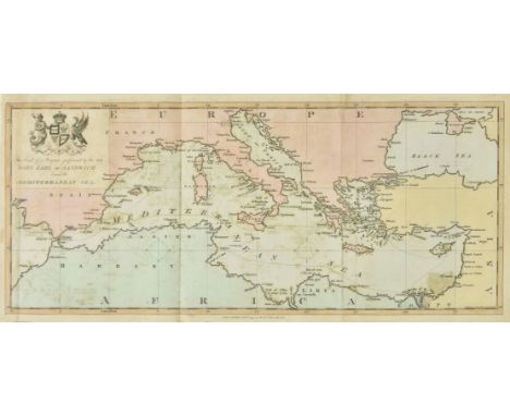

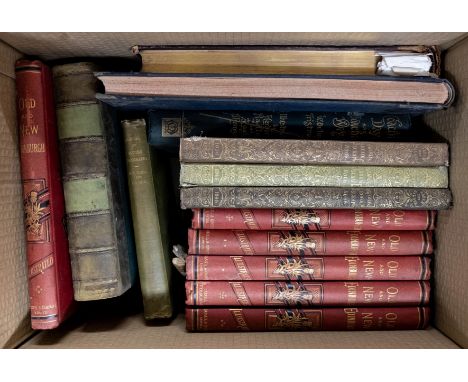
Sandwich (John Montagu, 4th Earl of). A Voyage performed round the Mediterranean in the Years 1738 and 1739. To which are prefixed, Memoirs of the Noble Author's Life, by John Cooke, 1st edition, London: for T. Cadell Jun. and W. Davies, 1799, engraved portrait frontispiece, 25 engraved plates, folding hand-coloured map, spotting and offsetting, frontispiece with repaired closed tear in margin, closed marginal tears in U3 touching shoulder-note and 3D1 touching headline, contemporary book-label of Henry Holdsworth, contemporary mottled calf, rebacked with original spine laid down, 4to (26.3 x 20.9 cm) (Qty: 1)NOTESAtabey 828; Blackmer 1149; cf. Cobham-Jeffery p. 55 (1807 edition). Sandwich embarked on a cruise of the Mediterranean as a continuation of his grand tour, visiting Athens, the Greek islands, Constantinople, Smyrna, Egypt and Malta.
We found 109198 price guide item(s) matching your search
There are 109198 lots that match your search criteria. Subscribe now to get instant access to the full price guide service.
Click here to subscribe- List
- Grid
-
109198 item(s)/page
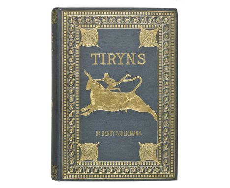
Schliemann (Henry). Tiryns. The Prehistoric Palace of the Kings of Tiryns, the results of the latest excavations, 1st edition in English, New York: Scribner's, 1885, folding frontispiece, folding map, 27 maps, plans and plates, several folding and colour, occasional slight offsetting, Easton Neston Library shelf number label to front pastedown, top edge gilt, original green cloth gilt, 4to (Qty: 1)NOTESA bright copy.
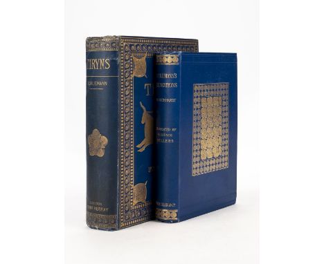
Schliemann (Henry). Tiryns. The Prehistoric Palace of the Kings of Tiryns. The results of the latest excavations, 1st UK edition in English, 1886, folding frontispiece,folding map, 27 maps, plans and plates, a few folding and colour, a little minor spotting, bookplate of George Bennett, M.D., F.R.C.S. (1804-1893, English born Australian physician and naturalist), top edge gilt, original blue cloth gilt, spine a little rubbed with small repaired tear at head, 4to, together with Schuchhardt (Dr. C.) Schliemann's Excavations. An Archaeological and Historical Study, translated from the German by Eugenie Sellers, 1st edition in English, 1891, portrait frontispiece, maps, plans and illustrations, a few folding, press cuttings tipped-in at end, a little minor spotting, original blue cloth gilt, 8vo (Qty: 2)
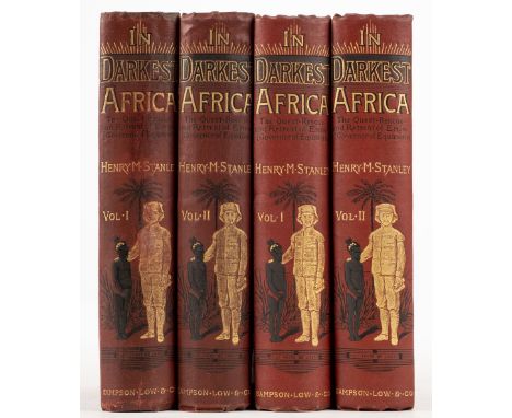
Stanley (Henry M.) In Darkest Africa or the Quest and Retreat of Emin Governor of Equatoria, 2 volumes, 1st edition, 1890, 3 folding maps (volume I map washed and re-guarded?), illustrations, some light rippling and a little spotting, volume I front hinge broken, bookplate, original red decorative cloth gilt, volume I spine tips repaired, 8vo, together with another set of the same work (volume II lacking first map) (Qty: 4)

Thomson (John). A General Atlas..., Edinburgh, London & Dublin, circa 1828, calligraphic title with near contemporary ownership signature and some water staining, forty-three of forty-four engraved maps with contemporary outline colouring, (lacking map of the world on Mercator's projection), a few maps trimmed with slight loss to printed image, some light toning throughout, slight water staining, some marginal dust and finger soiling, index bound at rear, contemporary half morocco, re-backed, some wear to extremities, 4to (Qty: 1)

Bird (Charles). Picturesque Old Bristol. A Series of Fifty-Two Etchings ... with Letterpress by John Taylor, 2 volumes, Bristol: Frost and Reed, 1885, 53 etched sepia plates (including frontispiece), tissue-guards, volume 2 with half-title, index leaf and publisher's notice, offsetting to tissue-guards, occasional spotting, contemporary half morocco gilt, joints & extremities rubbed and slightly worn, large 4to, together with Egan (Pierce) , Walks through Bath, Describing every thing worthy of interest connected with the Public Buildings, the Rooms, Crescents, Theatre, Concerts, Baths, its Literature, &c. including Walcot and Widcombe, and the Surrounding Vicinity; with Sketches of Prior Park House, the Rocks of Wick, Corsham House..., also an Excursion to Clifton and Bristol Hot-Wells..., Bath: Meyler & Son, 1819, half-title, engraved frontispiece and 20 plates, bound with Tunstall (James) , Rambles about Bath, and its Neighbourhood, 2nd edition, 1848, engraved frontispiece and 13 plates, without map, occasional spotting, all edges gilt, near contemporary half morocco, slight loss of leather at head of spine, old small paper label to central panel, extremities rubbed, thick 8vo (Qty: 3)NOTESPicturesque Old Bristol: Limited edition 7/125. 25 copies of the artist proof edition were printed on large paper, with each etching signed by the artist. There were also as here 125 unlettered proof copies on smaller paper, and 240 sets of etchings without letterpress; the publisher's notice in the second volume notes that many of the latter were sent to the colonies.
Birmingham. Wrightson's Annual Directory of Birmingham, including an alphabetical list of the Inhabitants of the Town; a complete Classification of the Trades; a new arrangement of Mails, Coaches, and Carriers, under the places to which they go..., Birmingham: R. Wrightson, 1829-30, numerous engraved & lithograph plates advertising trades and tradesmen (few folding), ink stain to fore-margin of initial few leaves, modern calf-backed printed boards, red morocco title label to boards, 8vo, together with The Directory of Birmingham; including an alphabetical list of the Inhabitants of the Town; a Classification of its Merchants, Manufacturers, &c..., A new arrangement of Mails, Coaches, and Carriers..., Birmingham: Wrightson & Webb, 1835, folding engraved map, numerous engraved plates advertising trades and tradesmen , modern brown half morocco, red morocco title label to spine, 8vo, plus Smith (William Hawkes) , Birmingham and South Staffordshire; or Illustrations of the History, Geology, and Industrial Operations of a Mining District, London: Charles Tilt, 1838, engraved frontispiece, folding plan and numerous plates including adverts for trades, front free endpaper with pasted-in author's signature, and bookplate of Eric S. Quayle of Greensleeves, Sutton Coldfield to front pastedown, original cloth-backed boards, short tear to lower joint, wear at head of spine, 8vo, plus Parson (William & White, William) , History, Directory, and Gazetteer, of the Counties of Durham and Nothumberland, and the Towns and Counties of Newcastle-Upon-Tyne and Berwick-Upon-Tweed, 2 volumes, 1827, without maps, contemporary calf, both volumes neatly rebacked, with gilt decorated spines and red maroon morocco title labels, large 12mo in 6s (Qty: 5)
Camden (William). Britannia: or a Chorographical Description of the flourishing Kingdoms of England, Scotland and Ireland and the Islands adjacent..., enlarged by the latest discoveries by Richard Gough, 3 volumes, London: John Nichols for T. Payne and Son, G. G. J. and J. Robinson, 1789, engraved portrait frontispiece to volume 1, 57 uncoloured engraved maps by John Cary (including 52 double-page or folding), and 96 uncoloured engraved plates (including 8 double-page), some maps trimmed with slight loss to printed margins, map of Lincolnshire trimmed along part of fold with slight loss, one double page table, occasional spotting, offsetting & toning, two leaves of text in volume 3 torn to lower outer blank corners, last few leaves in volume 3 lightly damp mottled, bookplate to each volume with motto Deo Ducente, contemporary diced calf gilt, upper boards of volume 1 & 2 and both boards of volume 3 detached, other joints cracked and weak, rubbed and worn to spines & extremities (particularly volume 1 spine), folio (Qty: 3)

Coburn (Alvin Langdon , illustrator ). Manchester & the Sea, Manchester: Cloister Press, circa 1926, tipped-in monotone plates from photographs by Coburn, folding map, contemporary navy morocco, gilt blocked title and presentatoion name 'The Honourable Sir Bijay Chand Mahtab, Maharajadhirija Bahadur of Burdwan G.C.I.E. K.C.S.I. I.O.M.', slim 4to, together with The Story of the Bale, Manchester: Lloyd's Packing Warehouses, 1926 (2 copies), monotone plates by Coburn, original japanese vellum backed boards, title label to upper cover, few marks, slim 4to, and Manchester Civic Week October 2nd to 9th 1926, Official Handbook, Manchester: Civic Week Committee, 1926, monotone plates, folding colour map, original mock leather, slim 4to, plus A Study in Storage, Manchester: Lloyd's Packing Warehouses, circa 1920s, monotone plates, maps in black & orange, original wrappers, image to upper cover, spine & extremities worn, slim 4to. AMENDMENT: The copy of Scarti di Cotone has been withdrawn from this lot (Qty: 5)
Dugdale (William). The Antiquities of Warwickshire, Illustrated from Records, Leiger-Books, Manuscripts, Charters, Evidences, Tombes and Armes: Beautified with Maps, Prospects and Portraictures, 2 volumes, 2nd edition, 1730, Large Paper copy, titles printed in red & black, 5 double page engraved maps (including county map and 4 maps of the county hundreds), 20 engraved plates (including 14 double page & portrait frontispiece to volume 1), numerous engravings to text, with many by Hollar, few minor marks, later endpapers, bookplates of Thomas Barrett of Lee and Herbert Louis Wade of Honiley to upper pastedowns, contemporary mottled calf, both volumes neatly rebacked with contrasting red & green morocco labels, corners repaired, folio (leaf size 46.5 x 27 cm) (Qty: 2)NOTESUpcott p.1259-1262. Large Paper copy.
Taylor (George & Skinner, Andrew). Map of the Roads of Ireland, Surveyed 1777, 1st edition, published for the authors as the Acts direct 14th Novr. 1778, uncoloured folding engraved map of Ireland facing title (some soiling and marks, relined, with minor loss to one fold), engraved vignette title and engraved dedication leaf and 12 pages of printed index (pages numbered v-xvi), 288 engraved road maps printed back to back, list of subscribers at rear (one or two leaves close-trimmed to fore-edge, touching text), some browning due to water staining at front and rear, contemporary wallet-style calf, with tie, gilt spine label, rubbed and some minor wear, 8vo (Qty: 1)
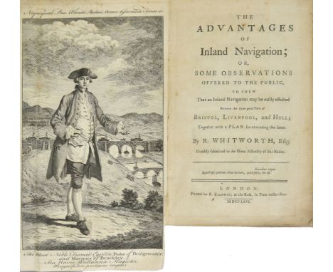
Whitworth (Richard). The Advantages of Inland Navigation; or, some Observations offered to the Public to shew that an Inland Navigation may be easily effected between the three Great Ports of Bristol, Liverpool, and Hull, 1st edition, London: for R. Baldwin, 1766, engraved portrait frontispiece (folding), 4 letterpress tables (folding), lacking map, closed tear in gutter of B6, contemporary sprinkled sheep, front joint cracked but firm, 8vo (20.2 x 12.6 cm) (Qty: 1)NOTESESTC T138831. Uncommon: no other copy traced in auction records since 1981.
![[Wilson, William]. Post-Chaise Companion: or, Travellers Directory through Ireland..., Dublin, 1786, engraved frontispiece, e](https://cdn.globalauctionplatform.com/4ed434fc-96bc-4961-9100-aaef00bec11d/4836f7e7-95d7-4e32-b5f3-aaf1010f3152/468x382.jpg)
[Wilson, William]. Post-Chaise Companion: or, Travellers Directory through Ireland..., Dublin, 1786, engraved frontispiece, engraved title, subscriber's list, 3 double-page engraved plates, folding engraved map hand-coloured in outline, errata leaf and endpapers detached, some light spotting and soiling, contemporary tree calf, covers detached, worming at foot of lower cover, spine rubbed, 8vo (Qty: 1)
![British Isles. Hollar (Wenceslaus), Untitled map of the British Isles, [1659 or later], uncoloured etched map surrounded by s](https://cdn.globalauctionplatform.com/4ed434fc-96bc-4961-9100-aaef00bec11d/1dbe9b4d-afea-4348-a0a7-aaf1010ec5e8/468x382.jpg)
British Isles. Hollar (Wenceslaus), Untitled map of the British Isles, [1659 or later], uncoloured etched map surrounded by sixteen vignettes and a view of Prague, with descriptive verse below image, trimmed to image and 'window mounted' on to later paper, 290 x 350 mm (Qty: 1)NOTESA scarce allegorical map which offers a satirical political commentary on the Thirty Years War and the English Civil War. R.W.Shirley. Early Printed Maps of the British Isles, no.529. 3rd state.
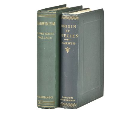
Wallace (Alfred Russel). Darwinism. An Exposition of the Theory of Natural Selection with some of its Applications, 1st edition, 1889, portrait frontispiece, illustrations, folding colour map, advertisement leaf at end, previous owner signature, bookplates, original green cloth, spine slightly darkened, 8vo, together with Darwin (Charles). The Origin of Species by Means of Natural Selection, or the Preservation of Favoured Races in the Struggle for Life, 6th edition, fifty-sixth thousand, 1899, folding diagrammatic plate, advertisement leaf at end, a little light offsetting and spotting, original green cloth gilt, spine a trifle darkened, 8vo (QTY: 2)NOTESFirst work from the library of author John Fowles (his bookplate); second work Freeman 457.
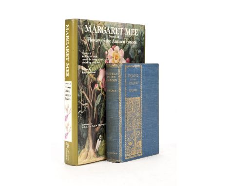
Wallace (Alfred Russel). Travels on the Amazon and Rio Negro, with an Account of the Native Tribes, and Observations on the Climate, Geology, and Natural History of the Amazon Valley, edited by George Thomas Bettany, Ward, Lock, circa 1900, portrait frontispiece, map and 10 plates, a few illustrations to text, title and frontispiece tissue-guard spotted, contemporary ink ownership of W.A.F. Balfour Browne, Glasgow, 4 April 1901 to half-title and later ballpoint pen inscription of Margaret Mee dated at London, October 1966 beneath, original gilt-decorated blue cloth, a little rubbed, 8vo, together with Mee (Margaret Ursula) , In Search of the Flowers of the Amazon Forests, edited by Tony Morrison, Woodbridge: Antique Collectors' Club for Nonesuch Expeditions, 1988, colour and black & white illustrations throughout, autographs of Margaret Mee's friends and admirers on blank versos of front and rear free endpapers and first and last leaves plus one loosely inserted sheet, original cloth in dust jacket, 4to (Qty: 2)NOTESThe first work is a reprint of the Minerva Library second edition of 1889. The association between the entomologist Balfour-Browne (1874-1967) is of note, since 'Unlike most of his contemporaries, Balfour-Browne ... was inspired less by Darwin than by the other great Victorian naturalist, A.R. Wallace ..., and his ideas about geographical distribution. This influence, his early interest in beetles, and a taste for studying organisms in their natural environment, led Balfour-Browne, after a restless start, to a lifelong study of the distribution of British water beetles' (ODNB). Margaret Mee sadly died in a car crash, in which her husband Greville (from whose library these books originate) was seriously injured, on 30 November 1988. This was the same month that her book was published, and this copy has been inscribed by many of Mee's friends and associates from Brazil. The reception was intended as a book launch and a homecoming party for Margaret, but after her death the reception went ahead as a homage.
![Blackburn [Jemima]. Birds drawn from Nature, 2nd edition, Glasgow: James Maclehose, 1868, 45 lithographic plates including pi](https://cdn.globalauctionplatform.com/4ed434fc-96bc-4961-9100-aaef00bec11d/fec843d0-cf38-4d21-9554-aaf1010f43fc/468x382.jpg)
Blackburn [Jemima]. Birds drawn from Nature, 2nd edition, Glasgow: James Maclehose, 1868, 45 lithographic plates including pictorial title-page, title-page spotted, a few later text-leaves strengthened with tape along fore edges, all edges gilt, original green cloth, recased, covers mottled, folio, together with: Campbell (Archibald James). Nests and Eggs of Australian Birds, 1st edition, Sheffield: for the author by Pawson & Brailsford, 1900, 2 halftone portrait frontispieces, map, 28 chromolithographic plates, all halftone plates as called for, printed slip with date to title-page, a few plates slightly nicked or creased, plate facing p. 12 repaired, original cloth, recased, rubbed and marked, wear to extremities, 8vo, Pleske (Theodore), Birds of the Eurasian Tundra, 1st edition, Boston: for the society, 1928, 17 heliotype plates, 6 colour plates, library label to front pastedown, original green cloth, 4to, Arnold (E. C.), Birds of Eastbourne, 1st edition, Eastbourne: Strange the Printer, Limited, 1936, colour plates, autograph letter signed from the author tipped in, original cloth, 4to, Wrigley (John), Notes on the Bird Life of Formby, 1st edition Liverpool: for private circulation, [1892], 4 lithographic plates, original cloth, marked, 4to, and 1 other (Qty: 7)NOTESNissen IVB 170 (Campbell), 107 (Blackburn), 733 (Pleske); Wood pp. 242 (Blackburn), 277 (Campbell, with date 1901), 520 (Pleske: 'a very useful account'); Whittell p. 111 (Campbell); Zimmer p. 123 (Campbell). The list of subscribers for Wrigley's work records a total of 71 copies.

British Isles . Lewis (Samuel), A Map of England & Wales, Divided into Counties, Parliamentary Divisions & Dioceses, shewing the principal Roads, Railways, Rivers & Canals..., 1839, four large engraved maps with contemporary outline colouring, some off-setting, slight staining and spotting, each map approximately 870 x 1050 mm, together with an additional three sections on Scotland, each map approximately 645 x 1310 mm, uniform contemporary morocco gilt, some wear and slight fraying to spines (Qty: 7)

Dunn (Robert). The Ornithologist's Guide to the Islands of Orkney and Shetland, 1st edition, London: published by the author, 1837, half-title, lithographic plate, 2 folding maps, plate slightly spotted, original fine-diaper cloth, paper spine-label, spine sunned and slightly frayed, together with: Kennedy (Alexander W. M. Clark), The Birds of Berkshire and Buckinghamshire, 1st edition, Eton: Ingalton and Drake, 1868, half-title, 4 hand-coloured albumen prints mounted on card, tissue-guards, half-title and final text-leaf browned, front inner hinge partially cracked at head, occasional light spotting, original green pictorial cloth gilt, a bright copy, Harvie-Browne (John Alexander), The Capercaillie in Scotland, 1st edition, Edinburgh: David Douglas, 1879, half-title, 2 etched plates including frontispiece, double-page map, frontispiece spotted, a few other marks, bookplate, ownership inscription ('Allan Gilmour') to half-title, original green pictorial cloth gilt, extremities rubbed, tips bumped, Rodd (Edward Hearle), The Birds of Cornwall and the Scilly Islands, edited ... by James Edmund Harting, 1st edition, London: Trübner & Co., 1880, autotype frontispiece, folding map, bookplate of Sir James Lumsden of Arden (1808-1879), largely unopened, original purple cloth, vignette blocked in bronze to front board, a bright copy, and 13 others, mainly 19th-century county or local avifaunas, original cloth, good copies, all 8vo (Qty: 17)NOTESFreeman 2071 (Kennedy); Gernsheim 436 (Kennedy); Mullens & Swann pp. 186 (Dunn), 326 (Kennedy), 281 (Harvie-Browne), 495 (Rodd); Wood pp. 327 (Dunn), 416 (Kennedy), 379 (Harvie-Browne), 540 (Rodd). Kennedy's work is the first ornithological book to be illustrated with photographs.
![* Buckinghamshire. Speed (John), Buckingham both shyre and shire towne describ. 1st edition, published George Humble, [1611],](https://cdn.globalauctionplatform.com/4ed434fc-96bc-4961-9100-aaef00bec11d/00adf1e8-a16f-4684-9903-aaf1010ec72b/468x382.jpg)
* Buckinghamshire. Speed (John), Buckingham both shyre and shire towne describ. 1st edition, published George Humble, [1611], uncoloured engraved map, inset town plans of Buckingham and Reading, slight browning to central fold, some closed repaired tears at base of central fold, 380 x 505 mm, mounted, framed and glazed (Qty: 1)

König (Alexander Ferdinand). Reisen und Forschungen in Algerien, 2 volumes in one, 1st edition, [Berlin: R. Friedländer, 1895-6], 24 photographic plates, 14 hand-coloured lithographic plates after J. G. Keulemans or E. de Maes, 2 chromolithographic plates, folding map, pencilled marginalia to volume 2, rear inner hinge tape-repaired, contemporary pebble-grain maroon cloth, spine lettered in gilt, 8vo, together with: Hume (Allan, editor), My Scrap Book: or Rough Notes on Indian Oology and Ornithology, 2 parts in one volume [all published], 1st edition, Calcutta: C. B. Lewis, 1869, browning, closed tear to pp. 259/60, a few marginal worm-tracks to outer leaves, original blue cloth, recased, 8vo, Harvie-Brown (John Alexander), Travels of a Naturalist in Northern Europe. Norway, 1871, Archangel, 1872, Petchora, 1875, 2 volumes, 1st edition, London: T. Fisher Unwin, 1905, 25 plates, 4 folding maps, original red cloth, 8vo, Wright (R. G., & Douglas Dewar), The Ducks of India, 1st edition, London: H. F. & G. Witherby, 1925, 22 colour plates, original cloth (spine faded, mottling to covers), dust jacket (edges reinforced with tape verso), 8vo, and 3 similar works, including Salim Ali, Handbook of the Birds of India and Pakistan, 10 volumes, 1st edition, 1968-74 (Qty: 17)NOTESWood pp. 420 (König), 394 (Hume), 637 (Wright); Zimmer pp. 313 (Hume), 292-3 (Harvie-Brown). König's work is rare, with no other copy traced at auction, and no record in Nissen or Anker. It may have originally appeared in the Journal für Ornithologie, which is referenced in the captions to the colour plates. The photographic plates include several interesting ethnographic studies.

Lilford (Thomas Littleton Powys, 4th Baron). Notes on the Birds of Northamptonshire and Neighbourhood, 2 volumes, 1st edition, large-paper issue, London: R. H. Porter, 1895, half-titles, frontispiece, 24 photogravure plates after drawings by Archibald Thorburn, 43 wood-engraved plates after G. E. Lodge, linen-backed folding map, top edges gilt, others untrimmed, contemporary green half morocco, spines sunned to tan, 4to (28.5 x 21.5 cm) (Qty: 2)NOTESProvenance: Harry Clarke Jervoise (1832-1911), British diplomat (engraved bookplates). Mullens & Swann p. 355; cf. Nissen IVB 564, Wood p. 436, Zimmer p. 400 (all for the octavo issue). According to Mullens and Swann there were 100 large-paper copies only, printed for subscribers. In the octavo issue Lodge's illustrations are printed in the letterpress rather than as separate plates.

Loyd (Lewis R. W.). Lundy. Its History and Natural History, 1st edition, London: Longmans, Green and Co., 1925, halftone plates (a few spotted), folding map, 2 laid-in autograph letters signed from ornithologist Pilcher George Ralfe (1861-1936), original cloth, dust jacket (restored), together with: Guthrie-Smith (Herbert), Mutton Birds and Other Birds, 1st edition, Christchuch: Whitcombe and Tombs Limited, 1914, photogravure frontispiece, 72 plates (one photogravure, the rest halftone), bookplate, original pictorial cloth gilt, dust jacket (restored), Gordon (Seton), Amid Snowy Wastes. Wild Life on the Spitsbergen Archipelago, 1st edition, London: Cassell and Company, Limited, 1922, halftone plates, 2 maps, original blue cloth (slightly cockled on front board), dust jacket (repairs verso), Chapman (Abel), Memories of Fourscore Years Less Two, 1851-1929, 1st edition, London: Gurney and Jackson, 1930, photogravure frontispiece, 27 plates (most in colour), text-illustrations, top edge gilt, others untrimmed, original cloth, dust jacket (repairs verso), and 20 others, all early or mid-20th-century general ornithology, original cloth, dust jackets, 8vo (Qty: 27)NOTESWood pp. 442 (Loyd), 372 (Guthrie-Smith: 'A charming and popular account of Puffinus griseus and some other New Zealand birds').
![Mosley (Seth Lister & Frederick Ormrod). An Account of the Birds of the Huddersfield District, 1st edition, [Huddersfield]: i](https://cdn.globalauctionplatform.com/4ed434fc-96bc-4961-9100-aaef00bec11d/d5c66b52-9bd1-4edc-9d0e-aaf1010f5560/468x382.jpg)
Mosley (Seth Lister & Frederick Ormrod). An Account of the Birds of the Huddersfield District, 1st edition, [Huddersfield]: issued privately to subscribers only, [1912-15], [12] 7-64 64-103 [3] pp., halftone portrait frontispiece, 39 hand-coloured lithographic plates, 38 hand-coloured lithographic maps of bird distributions, occasional spotting to a text, a few trivial spots to plates, map CC slightly cockled, bookseller's ticket (J. Broadbent & Co., Huddersfield) to front free endpaper, contemporary red quarter sheep, spine sunned and scuffed, 8vo (21.5 x 13.2 cm) (Qty: 1)NOTESBallance p. 341; Nissen IVB 651; Wood p. 473; not in Mullens & Swann or Zimmer. 'This rare work was printed by the authors on a hand-press and issued in 20 parts, the 40 "crayon-watercolour plates" being prepared by a "new hand-process". The maps show the distributional areas of certain species - altogether a creditable and useful treatise on local ornithology' (Wood). Ballance, Nissen and Wood each cite 40 plates and 40 maps. However, the British Library cites 38 plates, and the maximal collation otherwise traced at auction is a copy with the frontispiece, 39 plates and 38 maps (in 2013), in addition to two copies with the frontispiece, 39 plates and 37 maps, and two more copies with 39 plates and 37 maps but the frontispiece unmentioned. With the exception of the final two plates, respectively the black-headed gull (numbered 38) and the red-necked grebe (unnumbered), and the map corresponding to the first of these, the plates and maps are tabulated in the text itself, with no apparent lacunae. OCLC identifies four institutional locations world-wide: British Library, McGill, Oxford, and Trinity College (Connecticut).Note: an additional copy has since been examined which contains a plate depicting the eared grebe, not present in this copy (4/11/2019).

Muirhead (George). The Birds of Berwickshire, 2 volumes, 1st edition, large-paper issue, Edinburgh: David Douglas, 1889-95, 10 wood-engraved or etched plates, 2 plans, folding map, top edges gilt, others untrimmed, original tan buckram, spines darkened, 4to, number 99 of 100 copies, together with: Lilford (Thomas Littleton Powys, 4th Baron), Notes on the Birds of Northamptonshire and Neighbourhood, 2 volumes, 1st edition, London: R. H. Porter, 1895, photographic frontispiece, photogravure plates from drawings by Archibald Thorburn, wood-engravings after G. E. Lodge in the text, linen-backed folding map, inscribed by the publisher on free endpaper, ownership inscription of ornithologist Hubert E. Pounds, top edges gilt, others untrimmed, original green cloth gilt, a bright copy, 8vo, Butler (Arthur G.), Birds of Great Britain and Ireland, Order Passeres ... illustrated by H. Grönvold and F. W. Frohawk, 2 volumes, 1st edition thus, Hull: Brumby & Clarke, Limited, [1908], 115 chromolithographic plates with tissue-guards, top edges gilt, others untrimmed, original blue buckram-backed cloth, spines sunned, 4to, Kennedy (Ewen), Life and Natural History Notes, 1st edition, Edinburgh: privately printed at the Ballantyne Press, 1913, photogravure frontispiece, 10 mounted colour plates, halftone plates, front free endpaper excised, rear inner hinge partially cracked, top edge gilt, others untrimmed, original brown buckream, 4to, Nicholl (Archibald Michael Cyprian), Adventures after Birds of Osborne. Being a Camera Record of some of the Birds found near the College, 1st edition, Newport, Isle of Wight: Yelf Bros, 1916, 55 halftone plates (many mounted on card), original cloth, photographic onlay to front board abraded, 4to, and 6 others, original cloth, 4to (Qty: 14)NOTESMullens & Swann pp. 426 (Muirhead), 355 (Lilford), 111-2 (Butler); Wood pp. 474 (Muirhead), 436 (Lilford), 492 (Nicholl).
![Central and Northern Europe. Schedel (Hartmund). Untitled map, Nuremberg, [1493], woodcut map with contemporary hand colourin](https://cdn.globalauctionplatform.com/4ed434fc-96bc-4961-9100-aaef00bec11d/b050fe98-e5a8-41c3-97a4-aaf1010ec875/468x382.jpg)
Central and Northern Europe. Schedel (Hartmund). Untitled map, Nuremberg, [1493], woodcut map with contemporary hand colouring, trimmed to neatline on right hand vertical margin, replaced in facsimile and re-margined, central fold and central portion of the map extensively restored and repaired on verso, the whole backed with archival tissue, 395 x 580 mm, German text on verso (Qty: 1)NOTESThe map is one of the earliest depictions of Scandinavia and the Baltic Coast, extending to Russia in the east and the British Isles in the west. In the south, the map extends south of the Alps to Istanbul, Venice and the northernmost coast of the Mediterranean Sea. Schedel's map is a cartographic landmark, widely regarded as being the earliest obtainable map of Central Europe available to collectors.

Pearson (Henry J.). "Beyond Petsora and Eastward." Two Summer Voyages to Novaya Zemlya and the Islands of Barents Sea, 1st edition, London: R. H. Porter, 1899, chromolithographic frontispiece, 88 halftone plates, 2 folding maps, top edge gilt, original green pictorial cloth gilt, together with: ibid., Three Summers among the Birds of Russian Lapland, 1st edition, London: R. H. Porter, 1904, 68 halftone plates, folding map, plate 7 marked, short closed tears to plate 35 (folding panorama), top edge gilt, original green cloth gilt, a few small marks, Haviland (Maud D.), A Summer on the Yenesei (1914), 1st edition, London: Edward Arnold, 1915, 16 halftone plates including frontispiece, 12 pp. advertisements dated 1916, a little spotting to text, contemporary gift inscription to front free endpaper, original cloth, dust jacket (edges strengthened with tape verso, spine faded, pale stain to front panel, Wilkinson (Edward Sheldon), Shanghai Birds. A Study of Bird Life in Shanghai and the Surrounding Districts, 1st edition, Shanghai: North-China Daily News & Herald Limited, 1929, 23 colour plates, halftone plate, original green pictorial cloth gilt, spine-ends slightly frayed, Verner (Willoughby), My Life among the Wild Birds of Spain, 1st edition, London: John Bale, Sons & Danielsson, Ltd., 1909, all halftone plates as called for, folding plate on linen to rear, original green pictorial cloth gilt, all 8vo (Qty: 5)NOTESWood p. 514 (Pearson, both works), 380 (Haviland), 628 (Wilkinson: 'A very useful and well prepared systematic account'), 612 (Verner: 'An interesting, semi-popular work'). Haviland's work is scarce in the dust jacket.

* Cheshire. Blaeu (Johannes), Cestria Comitatus Palatinus, Amsterdam, circa 1645, engraved map with contemporary hand colouring, large margins, 380 x 500 mm, framed and glazed, together with Swire (William), Manchester and its environs engraved from an Actual Survey..., for the History, Directory and Gazetteer of Lancashire by Edwd. Baines, 1824, hand coloured engraved city plan, old folds, some damage and splitting to folds and appears to have been laid on later paper, 410 x 515 mm, mounted, framed and glazed (Qty: 2)
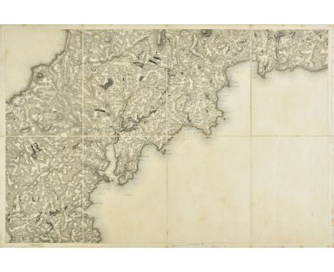
Cornwall. Mudge (Lt Col.), Ordnance Survey map of Cornwall, 1813, five engraved sheets with sparse contemporary outline colouring, sectionalised and laid on linen, slight dust soiling, each sheet approximately 610 x 910 mm, contained in a contemporary calf book-box with the crest of the Ordnance Survey on the upper siding, the box, worn and frayed (Qty: 1)NOTESThe map has a smaller calligraphic title sheet but this is erroneously the title sheet for Devonshire and not Cornwall.

Australia. Bellin (Jacques Nicolas), Carte reduite des Terres Australes..., published Paris, 1753, engraved map, old folds, slight overall toning, 210 x 285 mm (Qty: 1)NOTESOriginally published in Prevost's 'Histoire Generale des Voyages'. A geographically naive 'pre Cook' map showing the Eastern coastline of Australia running unbroken from Tasmania up to New Guinea.


* Devon. Speed (John), Devonshire with Excester described and the armes of such nobles as have borne the titles of them, published John Sudbury & George Humble, [1611], u ncoloured engraved map, inset town plan of Exeter, 385 x 510 mm, facsimile of text on verso of frame, mounted, framed and glazed (Qty: 1)
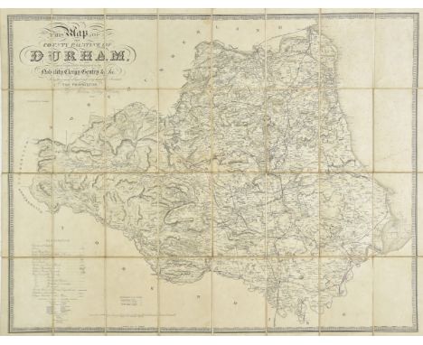
Durham. Hobson (William Colling), This Map of the County Palatine of Durham is most respectfully dedicated to the Nobility, Clergy, Gentry &c. &c. by their most Obliged and very Humble servant, the Proprietor, 1840, large scale map, engraved by J & C Walker, sectionalised and laid on linen, sparse near contemporary outline colouring identifying the railways, calligraphic title and table of explanation, occasional pencil annotations, slight dust soiling and staining, 790 x 980 mm (Qty: 1)
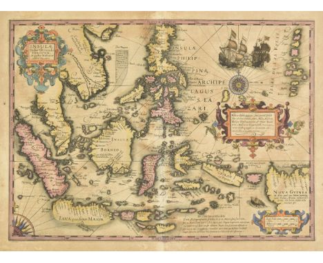
East Indies. Hondius (Jodocus), Insulae Indiae Orientalis Praecipuae in quibus Moluccae Celeberrimae sunt, Amsterdam, circa 1607, engraved map with contemporary hand colouring, two ornate cartouches and mileage scale, toned overall, central fold professionally reapired on verso, repaired marginal closed tears, 345 x 475 mm, Latin text on verso (Qty: 1)
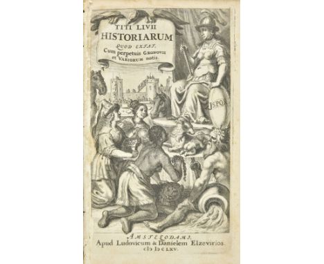
Livy . Titi Livii Historiarum quod extat, cum perpetuis Gronovii et Variorum notis, 3 volumes, Amsterdam: Ludovicum & Danielem Elzevirios, 1665, engraved title to volume 1, letterpress titles to volumes 2 & 3 with printer's woodcut device and imprint dated 1664 (light dampstain to volume 3 title), occasional light spotting, armorial bookplate of William Orme Foster to upper pastedowns, contemporary vellum, volume 1 rebacked, 8vo, together with Lucanus (Marcus Annaeus) , De Bello Civili, cum Hug. Grotii, Farnabii notis integris and variorum selectis, Amsterdam: Ex Officina Elzeviriana, 1658, engraved title, folding engraved map, some toning and spotting, bookplate of William Orme Foster to upper pastedown, contemporary vellum, 8vo (Qty: 4)NOTESProvenance: William Orme Foster (1814-1899) was an iron & coalmaster and the owner of the industrial firm John Bradley & Co. He served as a Liberal MP for South Staffordshire from 1857 until 1868. Willems 1358 & 1234.

Eastern Europe. Munster (Sebastian), Tabula Europae VIII, published H. Petri, Basel, circa 1552, hand coloured woodcut map on a trapezoidal projection of the Baltic Sea, Eastern Europe, Ukraine and the Black Sea, elaborate woodcut borders to text on verso credited to Hans Holbein, 270 x 340 mm (Qty: 1)


England & Wales. Walker (J. & C.), A Geological Map of England, Wales and part of Scotland, showing also the Inland Navigation by means of Rivers & Canals, with their elevation in feet above the Sea, together wth the Rail Roads and Principal Roads, published J. & C. Walker, March 31st. 1837, 1838, engraved map with contemporary hand colouring, sectionalised and laid on linen, calligraphic title, table of explanation, geological and mineralogical cross section above and below map, slight browning, 1400 x 995 mm, contained in a contemporary green morocco gilt book box with contrasting gilt morocco label to spine, box a little faded and stained (Qty: 1)

* Essex. Speed (John & Norden John), Essex devided into Hundreds with the most antient and fayre towne Colchester described and other memorable monuments observed, 1st edition, published George Humble, [1611], hand coloured engraved map, inset town plan of Colchester, 385 x 510 mm, mounted, framed and glazed with a facsimile of the text on the verso fixed to the rear of frame (Qty: 1)
Beattie (William). The Ports, Harbours, Watering-Places, and Coast Scenery of Great Britain, 2 volumes in one, 1844, engraved portrait frontispiece, engraved titles and numerous plates by W.H. Bartlett, some dampstains and spotting, all edges gilt, disbound 4to, together with Brandon (Raphael & J. Arthur) ,Parish Churches; being Perspective Views of English Ecclesiastical Structures..., 1848, numerous lithograph plates and plans, scattered spotting, contemporary green half calf, joints split, worn, large 8vo, plus Barrow (John) , Mountain Ascents in Westmoreland and Cumberland, 1886, frontispiece lacking, some illustrations, folding map, dedication inscribed by the author, lacking front free endpaper, original cloth, extremities rubbed, 8vo, and Cocks (Alfred Heneage) , The Church Bells of Buckinghamshire, London: Jarrold & Sons, 1897, lithograph frontispiece and plates, original cloth gilt, extremities rubbed, large 8vo (limited edition of 430 copies), plus other miscellaneous books including The Church Bells of Suffolk, by John James Raven, 1890; The Church Bells of Bedfordshire, by Thomas North, 1883; My Cricket Memories by J.B. Hobbs, 1st edition, 1924; Annals of Cricket by W.W. Read, 2nd edition, 1896, plus British topography, literature, travel, and reference etc. (Qty: 3 cartons)
Phillips (John). The Rivers, Mountains and Sea-Coast of Yorkshire. With Essays on the Climate, Scenery, and Ancient Inhabitants of the County, 2nd subcribers' edition, London: John Murray, 1855, 35 lithograph plates (including frontispiece and hand-coloured map), scattered spotting, original green cloth gilt, spine faded, 8vo, together with Shirley (Evelyn Philip) , Some Account of English Deer Parks, with notes on the Management of Deer, London: John Murray, 1867, wood engraved frontispiece, original green cloth gilt, 4to, plus Howitt (William) , The Rural Life of England, 2nd edition, corrected and revised, 1840, wood engraved vignette to title with inscription, wood engraved vignette illustrations, original cloth gilt, spine darkened, 8vo, plus other miscellaneous books (Qty: 2 cartons)
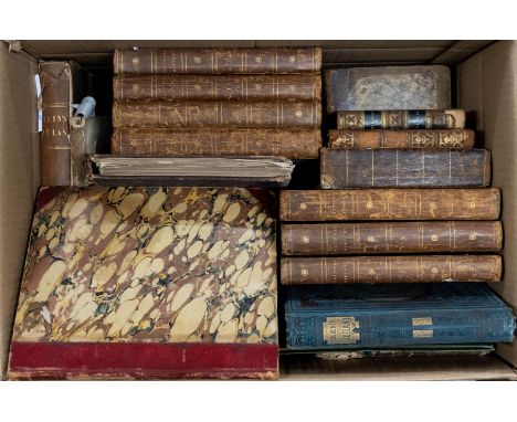
Spooner (William). Spooner's Pictorial Map of England & Wales, Arranged as an Amusing and Instructive Game for Youth. Illustrated with upwards of one hundred & twenty views, London: William Spooner, Nov. 5th, 1844, folding hand-coloured lithograph map sectionalised on linen, light spotting, original cloth covers with uncoloured lithograph pictorial title to upper board, spine faded, tie broken & lacking, map dimensions approximately 62 x 51 cm, together with Bowles (Carington) , Bowles's New Pocket Plan of the Cities of London & Westminster; with the Borough of Southwark: Comprehending the New Buildings and other Alterations to the Year 1789, folding hand-coloured engraved map sectionalised on linen, few ink marks, some dust-soiling and light wear, contained in original wallet case with printed title label (ink date written in manuscript), map dimensions approximately 48 x 94 cm, plus Phillips (William) , Outlines of Mineralogy and Geology, intended for the use of those who may desire to become Acquainted with the Elements of those Sciences; Especially of Young Persons, 3rd edition, 1818, 4 engraved plates (2 hand-coloured), edges untrimmed, original boards, 12mo, and [Anstey, Christopher] , The New Bath Guide: or Memoirs of the B.N.R.D. Family in a Series of Poetical Epistles, Bath, Printed and Published by John Browne, 1807, engraved title and 11 plates, some browning and spotting, original boards with later marbled paper adhered over, small 8vo, plus other miscellaneous 19th century antiquarian including a defective New National Encyclopaedia Atlas by William Mackenzie, 1868 and 11 odd volumes of Buffon's Natural History, published 1797-1808, etc. (Qty: a carton)
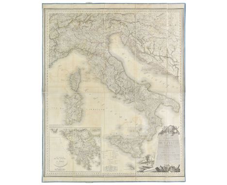
Europe. Four folding maps, circa 1820, including Orgiazzi (J. A.). Carte Statistique Politique et Mineralogique de l'Italie..., Paris, 1816, large wall map with contemporary outline colouring, sectionalised and laid on linen, some offsetting, edged in blue silk, 1190 x 1000 mm, together with Engelhardt (F. B. von). Karte von dem Königreich Pohlen, Gross-Herzogthum Posen und den angrenzenden Staaten in IV Sectionen, 1831, engraved wall map, with contemporary outline colouring, sectionalised and laid on linen, slight spotting, edged in blue silk, 900 x 950 mm, with Fallon (Ludwig August von, surveyor). Das oesterreichische-Kaiserthum mit beträchtlichen Theilen der angrenzenden Staaten..., 1822, two large engraved military wall maps of East and West Austria (but lacking the sheet for central Austria), sectionalised and laid on linen, slight browning, edged in blue silk, each approximately 1280 x 595 mm, all four maps enclosed by a contemporary waxed paper chemise and contained in a contemporary diced calf gilt book box, heavily worn and frayed (Qty: 1)

Pressly (William L.) . A Catalogue of Paintings in the Folger Shakespeare Library, 1993, Yale University Press, numerous colour and black & white illustrations, original cloth in dust jacket in slipcase, large 8vo, together with Gilbert (Christopher) , Pictorial Dictionary of Marked London Furniture 1700-1840, 1st edition, 1996, Furniture History Society, numerous black & white illustrations, original cloth in dust jacket in slipcase, large 8vo, and Hirst (Damien) , Beautiful Inside My Head Forever, 5 volumes, 2008, Sotheby's, numerous colour illustrations, all original wrappers in slipcase, large 8vo, plus other art, print & map reference, including A Series of Original Portraits and Caricature Etchings, 4 volumes, by John Kay, 1877, some leather bindings, many original cloth in dust jackets, some paperbacks, G/VG, 8vo/folio (Qty: 6 shelves)

* Europe. Munster (Sebastian), Untitled map of Europe depicted as a queen, Basel, circa 1580, uncoloured anthropomorphic woodcut map, with Iberia at the head with Italy and Denmark comprising the arms and Bohemia her heart, 290 x 170 mm, German text above and on verso of map, mounted, framed and glazed (Qty: 1)NOTESA design originally created by Bucius (Johannes Putsch) in 1537. It has been postulated that the character of the map is not a woman at all but a representation of Charles V of Spain showing Europe with Spain as its crown. The British Isles is depicted in the most rudimentary style under the sceptre

Map Reference . A collection of modern map history & reference, including A History of Cartography 2500 years of maps and mapmakers, by R.V. Tooley, 1st U.K. edition, 1969, The Exploration of North America 1630-1776, by W.P. Cumming et al, 1974, mostly original cloth, many in dust jackets, some duplicate volumes, G/VG, 8vo/folio (Qty: 4 shelves)
![Australia. Coronelli (Vincenzo), Het Niew Hollandt. Nuova Guinea, published Venice, [1697], uncoloured engraved globe gore of](https://cdn.globalauctionplatform.com/4ed434fc-96bc-4961-9100-aaef00bec11d/f24b9138-a9b5-4e6d-8dcf-aaf1010eb4b2/468x382.jpg)
Australia. Coronelli (Vincenzo), Het Niew Hollandt. Nuova Guinea, published Venice, [1697], uncoloured engraved globe gore of the Dutch discoveries in the Spice Islands, Papua New Guinea and Australia from the northwest Cape to the Gulf of Carpentaria around Weipa, map size 230 x 290 mm, Italian text below and on verso of map (Qty: 1)
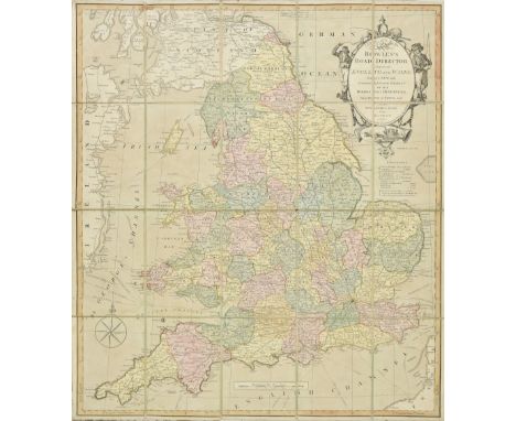
Folding maps. A collection of seven folding maps of England & Wales, 19th century, including Bowles & Carver (publishers). Bowles Road Director through England and Wales..., circa 1805, engraved map with contemporary hand colouring, sectionalised and laid on linen, large ornate cartouche, 600 x 530 mm, contained in a contemporary marbled slipcase with printed label to upper board, worn and frayed, together with Mogg (Edward). Mogg's New Map of England and Wales with part of Scotland..., 1831, large engraved map with contemporary hand colouring, sectionalised and laid on linen, large calligraphic title, table of explanation displayed in a 'curtain' cartouche, 1320 x 1050 mm, contained in a contemporary marbled card slipcase with a printed label to upper cover, worn and frayed at extremities, together with Cruchley (George Frederick). Cruchley's Improved Geographical Companion throughout England and Wales Including part of Scotland, 1825, engraved map with contemporary outline colouring, sectionalised and laid on linen, three extensive tables of explanation and reference, slight staining, 960 x 670 mm, printed title label as endpaper, contained in a contemporary card slipcase with duplicate label to upper cover, with Walker (John & Charles). England & Wales founded upon the Grand Trigonometrical Survey..., 1841, engraved map with contemporary hand colouring, sectionalised and laid on linen, calligraphic title, slight staining and offsetting, 1330 x 1010 mm, contained in a contemporary cloth slipcase with morocco gilt label to upper cover, lower corners crudely repaired with masking tape, with another copy similar, and two further folding maps by Wyld and Smith (Qty: 7)
T. Nelson And Sons . Souvenir of Scotland, 1892, numerous chromolithograph views, all edges gilt, period inscription to front endpaper, some minor spotting, publishers original gilt decorated blue cloth, lightly rubbed to head & foot, 4to, together with Granville (A.B.) , The Spas of England, and principal sea-bathing places, Northern Spas., Southern Spas., 2 volumes, 1841, Henry Colburn, black & white illustrations, advertisements to front & rear, light toning, uniform original embossed brown cloth, Northern Spas front board detached, boards & spines slightly rubbed & marked, 8vo, and William Pollard & Co. , A Book of The South West, 1907, Exeter, numerous black & white illustrations, advertisements & folding map to rear, some light toning, publisher's original gilt decorated full vellum, boards & spine lightly marked, 8vo, plus other late 19th century & modern U.K. topographical reference & related, including publications by Black, H.M.S.O., Batsford, mostly original cloth, some in dust jackets, G/VG, 8vo/4to (Qty: 6 shelves)

* Germany. Delarochette (Louis Stanislas D'Arcy), Map of the Empire of Germany including all the States Comprehended under that name with the Kingdom of Prussia &c., Laurie & Whittle, 1794, large engraved wall map with contemporary colouring and some later enhancement, on four conjoined sheets, old folds with some creasing and very slight fraying, upper right corner trimmed with slight loss to margin and replaced in facsimile, overall size 1015 x 1200 mm, mounted, framed and glazed (Qty: 1)NOTESThe map shows the Germanic territories in full from the Baltic Sea to the Gulf of Venice. Includes Germany, Austria, Bohemia (Czech Republic), Poland, Lithuania, Prussia, Switzerland, Holland, Belgium and Denmark.

* Glamorganshire. Speed (John), Glamorgan Shyre with the sittuations of the cheife towne Cardyff and ancient Llandaffe described, 1st edition, published John Sudbury & George Humble, [1611], uncoloured engraved map, inset town plans of Cardiff and Llandaff, large margins, slight staining, 385 x 515 mm, English text on verso, framed and double glazed (Qty: 1)


* Gloucestershire. Speed (John), Glocestershire contrived into thirty thre severall hundreds & those againe into foure principall devisions. The citie of Glocester & Bristowe discribed with the armes of such noble men as have bene dignified with ye titlles of Earles & Dukes thereof, 1st edition, published John Sudbury & George Humble, [1611], hand coloured engraved map, inset town plans of Bristol and Gloucester, slight browning to central fold, English text on verso, mounted, framed and double glazed (Qty: 1)

* Gloucestershire. Speed (John), Glocestershire contrived into thirty-thre severall Hundreds & those againe in to four Principall Devisions. The Citie of Glocester & Bristowe discribed with the Armes of such Noble man as have bene Dignified with ye Titles of Earles & Dukes thereof, published Henry Overton, circa 1710, hand coloured engraved map, inset city plans of Gloucester and Bristol, strapwork cartouche, trimmed to just inside neat line on vertical margins, skilfully repaired and any loss replaced in ink and watercolour, 380 x 505 mm, mounted, framed and glazed (Qty: 1)
![* Hampshire. Speed (John), Hantshire described and devided, Thomas Bassett & Richard Chiswell, [1676], hand coloured engr](https://cdn.globalauctionplatform.com/4ed434fc-96bc-4961-9100-aaef00bec11d/696e407f-08fc-41b1-b2f5-aaf1010edf70/468x382.jpg)
* Hampshire. Speed (John), Hantshire described and devided, Thomas Bassett & Richard Chiswell, [1676], hand coloured engraved map, inset town plan of Winchester, slight dust soiling, 380 x 505 mm, no text on verso, framed and glazed, together with Saxton (Christopher & Hole Guillaume). Northumbriae comitatus olim sedes Otadinorum [1610], hand coloured engraved map, 'open book' cartouche and large compass rose, 270 x 295 mm, mounted, framed and glazed (Qty: 2)

Heather (William). Untitled Composite Atlas of fourteen Sea Charts of the British coastline, 1793 - 1805, fourteen uncoloured folding and double page engraved charts, many with insets, with a double page engraved plate of Maritime flags with bright contemporary hand colouring at rear, bookplate of William Heather 'Chart and Map -Seller, The Navigation Warehouse, 157 Leadenhall Street' to front pastedown, contemporary half calf, over marbled boards, bumped and worn, large slim folio (Qty: 1)NOTESRare. No extant copies found. The charts consist of:- 1. Large untitled map of the British Isles orientated to the West, 780 x 1800 mm, published 1793. 2. Chart of the Downs and Margate Roads, 635 x 795 mm, published 1797, 3. Chart of Spithead, 635 x 785 mm, published 1797, 4. Chart of Plymouth Sound, A New Chart of the Race of Portland & A New Chart of the Entrances to Falmouth & Helford (three charts of one sheet), 645 x 800 mm, published 1798, 5. Heather's New & Improved Chart of the Isles of Scilly, 650 x 795 mm, published 1803, 6. Chart of the English Channel, 795 x 1880 mm, published 1805, 7. Chart of the Bristol Channel, 640 x 920 mm, published 1803, 8. A New and Correct Chart of St. George's Channel, 795 x 1850 mm, published 1804, 9. New and Improved Chart of the Hebrides or Lewis islands and Adjacent Coast of Scotland, 790 x 1250 mm, published 1804, 10. Heather;s New and Improved Chart of the Orkney Isles, 645 x 930 mm, published 1804, 11.New Improved Chart of the North Sea or the German Ocean, 950 x 1275 mm, published 1801, 12. Chart of the East Coast of England and Scotland from The Humber to Aberdeen, 645 x 785 mm, published 1798. 13. Chart of the East Coast of England, 645 x 785 mm, published 1802, 14. Chart of the Entrances to the River Thames, 640 x 790 mm, published 1801. William Heather occupied the premises on the bookplate from 1793 - 1812
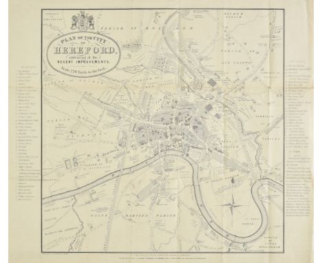
Herefordshire. A collection of thirty-seven maps, mostly 19th century, engraved county maps and town plans of Hereford and Leominster, with examples by Dawson, Lewis, James, Cole & Roper, Seller/Grose, Conder, Ordnance Survey, Weller, Collins, Bacon, J & C Walker, Hughes, Becker, Duncan, Moule, Archer, Fullarton, Hall, Pigot, Murray, Phillips, Smith and Harrison, including a reproduction map by Bickham and a reproduction road map by John Ogilby, various sizes and condition (Qty: 37)
![Herefordshire. Bill (John), Herefordshire, [1626 ], uncoloured engraved map, slight text show-through, 90 x 125 mm, English t](https://cdn.globalauctionplatform.com/4ed434fc-96bc-4961-9100-aaef00bec11d/ff20d11e-c27c-4346-bfe1-aaf1010ee1f0/468x382.jpg)
Herefordshire. Bill (John), Herefordshire, [1626 ], uncoloured engraved map, slight text show-through, 90 x 125 mm, English text on verso, together with Simmons (Matthew). H ereforshire with some confining Townes, [1635 or later], uncoloured engraved triangular mileage table with a simplified miniature map to lower right corner, engraved by Jacob Van Langeren, overall size 105 x 105 mm, near contemporary manuscript text to verso, with a later 1657 edition with the enlarged county map, with Ramble (Reuben). Herefordshire [1845], uncoloured map surrounded by lithographic topographical vignettes with contemporary hand colouring, overall size 190 x 155 mm, supplied with a page of contemporary descriptive text, plus Bowles (Carington). Bowles's Reduced Map of Herefordshire, [1785], uncoloured engraved map, 160 x 180 mm (Qty: 5)NOTESFive rare miniature maps of Herefordshire.
-
109198 item(s)/page