We found 109182 price guide item(s) matching your search
There are 109182 lots that match your search criteria. Subscribe now to get instant access to the full price guide service.
Click here to subscribe- List
- Grid
-
109182 item(s)/page


Lot 6559A
Emanuel Bowen (British 1694-1767): 'South Wales containing Burough and Market Towns and Rivers and Roads, engraved map with hand-colouring pub. 1762, 18cm x 20cm together with J & C Walker (British fl. 1820-1895): Map of America, engraved with hand colouring pub. 1831 under the Superintendence of the Society for the Diffusion of Useful Knowledge 27cm x 27cm (2) (unframed)


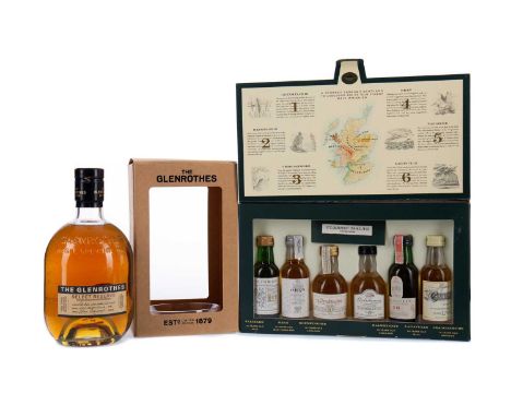
Lot 122
GLENROTHES SELECT RESERVESingle Malt Scotch Whisky700ml, 43% volume, in carton.CLASSIC MALTS OF SCOTLAND MINIATURES (6x5CL)Single Malt Scotch WhiskyIncludes Lagavulin aged 16 years White Horse Distillers (43%), Talisker aged 10 years Map Label (45.8%), Oban aged 14 years (43%), Glenkinchie aged 10 years (43%), Dalwhinnie aged 15 years (43%), and Cragganmore 12 years old (40%). All 5cl miniatures.


Lot 223
A COLLECTION OF APPROXIMATELY FIFTY SCOTCH WHISKY MINIATURESComprising of mainly single malts, including Bowmore 21 years old (43%), Laphroaig 10 yaers old (40%), Glenmorangie Port Wood Finish (43%), Talisker 10 years old Map Label (45.8%), Scapa 1985 (40%), Lagavulin aged 16 years White Horse Distillers (43%), and Glendronach Traditional aged 12 years (40%). All 5cl miniatures.Condition report: Please see additional photographs of the miniatures included in this lot.

Lot 327
CLASSIC MALTS OF SCOTLAND MINIATURE PACKIncludes Lagavulin aged 16 years White Horse Distillers (43%), Talisker aged 10 years Map label (45.8%), Oban aged 14 years (43%), Glenkinchie 10 years old (43%), Dalwhinnie aged 15 years (43%), and Cragganmore aged 12 years (40%). All 5cl miniatures, in carton.


Lot 416
WWIl Interest - an unusual RAF type ' Secret Map Domino ' comprising of a secret map hidden within a period domino. The top faux ivory-section removes to reveal a small section of a map showing North Africa. Items similar to this were used by captured British Airmen in order to aid their escape to allied territory during The War.

Lot 430
A scarce original WWII Second World War era British wooden map plotter / indicator. Simple wooden construction, with panels for various numbers / letters to be slid in. As used in various department rooms for plotting Luftwaffe courses or bomb drops during air raids. With a selection of assorted numbers. Measures approx; 8cm tall.


Lot 438
A WWII Second World War interest RAF silk escape map showing ' AAF Cloth Map - Asiatic Series ' 'For use by War and Navy Department Agencies only '. Dated 1944. Double sided. Along with an original US American 'escape kit' capsule featuring a compass to top and bakelite body containing matches.

Lot 455
A scarce original WWII Second World War era British brass map plotter / indicator. Chromed brass construction, with panels for various numbers / letters to be slid in. As used in various department rooms for plotting Luftwaffe courses or bomb drops during raids. With a selection of assorted numbers. Measures approx; 9.5cm tall.


Lot 15
A scarce original WWII Second World War period 1941 London Transport issued Underground map, showing the routes and stations in typical form. To the rear is a map of central London stations that are used a public Air Raid shelters. Scarce surviving document. Measures 6x9" when fully unfolded.

Lot 200
A scarce original WWII Second World War era British brass map plotter / indicator. Chromed brass construction, with panels for various numbers / letters to be slid in. As used in various department rooms for plotting Luftwaffe courses or bomb drops during raids. With a selection of assorted numbers. Measures approx; 19cm tall.


Lot 274
A scarce original WWII Second World War era British wooden map plotter / indicator. Simple wooden construction, with panels for various numbers / letters to be slid in. As used in various department rooms for plotting Luftwaffe courses or bomb drops during air raids. With a selection of assorted numbers. Measures approx; 9cm tall.


Lot 289
An original WWII Second World War period British Home Front ARP Air Raid Precautions issued bakelite Brodie helmet. Complete with a later liner and original chin strap. Painted notation to front ' AP EM ', believed to relate to Essex. Along with a 1940 dated folded paper map of Chatham and Maidstone.
Lot 193
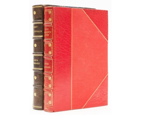
NO RESERVE Haggard (H. Rider) King Solomon's Mines, fourth printing, folding map with repaired tear, half-title, 16pp. undated advertisements at end, modern red crushed morocco, gilt, by Bayntun, 1885; Allan Quatermain, first edition, half-title, plates and illustrations, modern brown half morocco, 1887, 8vo (2)
Lot 20
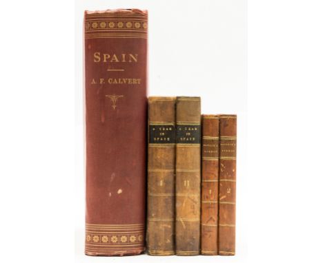
Spain & Portugal.- Baillie (Marianne) Lisbon in the Years 1821, 1822, and 1823, 2 vol., vignette titles, 8 aquatint plates, scattered spotting, bookplates, contemporary half-calf, gilt, rubbed, 1824 § [Mackenzie (Alexander Slidell)] A Year in Spain. by A Young America, 2 vol., engraved illustrations, spotting to first and last few leaves, bookplate, contemporary half-calf, a little rubbed, 1831 § Calvert (Albert F.) Spain, colour map frontispiece, plates and illustrations, previous owner's note tipped to title, strengthened hinges, original decorative cloth, bumping to corners and extremities, rubbed, [c.1917]; 8vo & 4to (5)

Lot 25
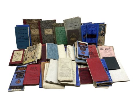
World.- Macdonald (Rev. Duff) Africana; Or the Heart of Heathen Africa, 2 vol., first edition, plates (with tissue guards) and illustrations, ink ownership inscription to titles, vol. 2 ink stamp to front endpaper, some spotting, original cloth, spines toned, light wear to spine ends, joints and extremities, 1822 § Doughty (Charles M.) Travels in Arabia Deserta, 2 vol., vol 1. with portrait frontispiece and folding coloured map (loose in pocket on lower pastedown, toned at fold on verso), illustrations and plates (some folding), endpapers browned, original cloth, spines sunned, ends a little worn, vol 2. tear along upper joint at spine head, 1923 § Agassiz (Prof. and Mrs) A Journey in Brazil, plates and illustrations, near contemporary ink notes to front endpaper, light marginal browning, original pictorial cloth, slight damp-stain upper cover, upper joint torn but holding firm, spine ends bumped, 1868; and 48 others travel, mainly Africa, Americas and Europe, v.s. (51)
Lot 26
World.- Wilkinson (William Henry) "Where the Chinese Drive". English Student-Life at Peking, first edition, 3 woodcut Chinese text blocks tipped-in, original cloth, small amount of light soiling, extremities lightly bumped, 1885 § Lovett (Richard) The History of the London Missionary Society 1795-1895, 2 vol., one of 250 copies signed by the author, plates and maps (some colour and folding), spotting to endpapers, original cloth-backed boards, spines toned, bumped at ends, a little scuffed, t.e.g., uncut, 1899 § Seebohm (Henry) Siberia in Asia, folding colour map, illustrations, bookplate to front pastedown, half-title loose, occasional spotting, upper hinge broken, original pictorial cloth, spine lightly toned, joints, spine ends and extremities a little rubbed, 1882; and 51 others travel, mainly Asia, India and the Pacific, v.s. (55)
Lot 34
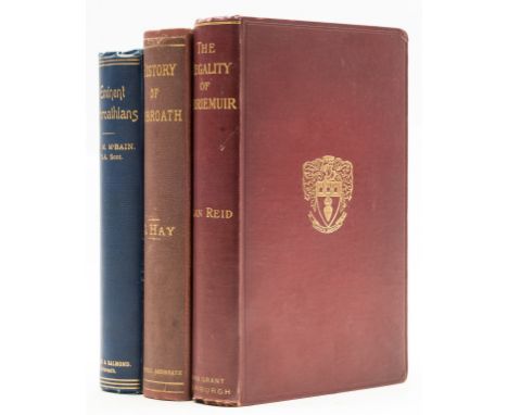
NO RESERVE Scotland.- Reid (Alan) The Regality of Kirriemuir, first edition, one of 650 copies, half-title, photographic frontispiece and 15 plates, folding map, illustrations, some splitting at gutter, endpapers browned with ink ownership inscription, spine ends and corners a little rubbed, t.e.g., 1909 § Hay (George) History of Arbroath, to the Present Time, first edition, frontispiece, 8 plates, frontispiece tissue-guard torn, ink inscription to title, rebacked with original spine laid-down, lightly rubbed, Arbroath, 1876, very occasional light spotting and finger-soiling, original cloth; and a study of eminent Arbroathians, 4to & 8vo (3)
Lot 35
NO RESERVE Surrey.- Salmon (Nathaniel) Antiquities of Surrey, first edition, extra-illustrated by the insertion of a folding engraved map by J. Gibson, folding frontispiece of Hampton Court, 3 plates of miniature portraits by Vertue, portrait of John Evelyn (dedicatee) and 11 other portraits, 26 engraved 18th and early 19th century plates, some folding, one by Hollar (mostly views of Surrey towns, villages and churches), later calf, gilt, spine faded, for the Author, 1736; and 7 others, miscellaneous, 8vo (8)
Lot 36
Big Game.- Thornhill (R.B.) The Shooting Directory, first edition, first issue, with pp.214-220 counted as one and pp.225-226 omitted, half-title, aquatint portrait and 6 aquatint plates, 2 engraved plates of which 1 folding, 3 folding tables, advertisement at end, A1 with short tear and neat repair, one or two marginal pencil notes, previous owner's ink signature to half-title, scattered spotting, bookplate, later half-calf, a little rubbed, [Schwerdt II p.258], 1804 § Maxwell (Marius) Stalking Big Game with a Camera in Equatorial Africa, frontispiece, plates, several folding, map, spotting, bookplate, contemporary half-morocco 1925; and 2 others similar, v.s. (4).
Lot 5
China.- Staunton (Sir George) An Authentic Account of an Embassy from the King of Great Britain to the Emperor of China, 3 vol. (including Atlas), second edition, engraved portrait frontispieces, both slightly offset onto titles, engraved plate and illustrations, Atlas vol. with 43 engraved plates and maps only (of 44, world map supplied in facsimile), some folding or double-page, occasional marginal damp-staining and spotting, browning, one plate with short tear to image caused by browning, abrasion mark to front free endpaper where label removed, text vol. in contemporary tree calf, rubbed, extremities worn, joints split, Atlas vol. in modern half-calf, 4to and folio, 1798.⁂ The second edition of this important account of Britain's first embassy to China, sent in 1792 and headed by Lord Macartney. Staunton was the secretary to the embassy which travelled via Madeira, Tenerife, Brazil, Java and Sumatra - the account includes a lengthy description of Rio de Janeiro, as well as one of the most important insights into Chinese life at the time.
Lot 8
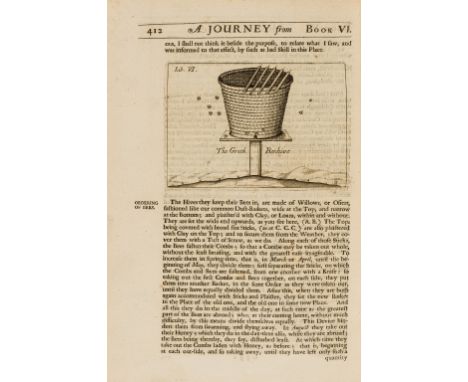
Greece.- Wheler (George) A Journey into Greece, first edition, folding engraved map and 5 plates (one divided into 3 smaller inserts), numerous engraved illustrations, occasional soiling and spotting, a few nicks at upper margin, later sprinkled calf, gilt, lower cover detached and with most of leather missing, head of spine chewed and slightly stained, encroaching on upper cover also, [Atabey 1328; Blackmer 1786; Wing W1607], folio, Printed for William Cademan, Robert Kettlewell, and Awnsham Churchill, 1682.⁂ Internally a very good copy generally and what was until recently a fine copy overall until the consignor's dog took a fancy to it and caused considerable damage by chewing the lower cover and top of spine. Probably reparable to recreate a very good copy again. Includes a description of the honey and bees from Mount Hymettus, south east of Athens with an illustration of a Greek Beehive (pp.409-413).Provenance: British Museum with duplicate stamp dated 1818 to verso of title and final leaf.


Lot 1437
A Wooden Tray Containing Mixed Collectables to include two folding measures, an old tape measure, a trench art style cigarette lighter, a spirit level with brass mount, a pair of binoculars, silver charm, map measure, a silver napkin hook, and a modern manual wind Masonic watch, and a box of dominoes etc.


Lot 28JH
Make & Model: Merc. A200 D Sport EditionDate of Reg: KU18 OMTColour: Whitecc: 2143MoT: 08-03-2022Fuel Type: DIESELMileage: 25kTransmission: AUTOSummary: Two registered keepers with the latest since July 2019. Extras include Garmin map pilot navigation system with SD card, panoramic sliding sunroof and 17' five twin spoke alloy wheels in black with high sheen finish. Two keys (not tested) Two service records on Mercedes service reportVehicle Check Sheet: https://angliacarauctions.co.uk/umbraco/surface/auction/GetVehicleCheckSheet?id=151351


Lot 126
Collection of Maps Relating to the Franco-Prussian War, produced in Germany showing the strategic positions of the German forces during the Franco-Prussian war of 1870-71. Various scales and areas, many show the positions of both Prussian and Bavarian forces in relation to those of the French. Sixteen maps in total. Various conditions, all folded; linen backed German / Austrian map of “Osterreichischen Kaiserstaates”, coloured, produced by Josef Scheda Vienna (Wein) 1847; 2x Imperial German official documents


Lot 145
Small WW1 Photograph Album of Gallipoli Interest, with images of Seddul Bahr in ruins and River Clyde, also Turkish shells exploding on the Peninsular, other images show Egypt, local scenes, men of Egyptian Labour Corps, shell holed Turkish Pontoons Ismalia, unloading camels, panorama of Jerusalem, Turkish prisoners, outside Beersheba, c.85 photographs in all, some age faded. Also coloured silk map of Turkey, Gallipoli and the surrounding territories. (2)

Lot 30
Very Large Collection of War Graves Registers Published by the War Graves Commission, London and later Maidenhead. Believed to be a complete or close to complete run of c.980 Registers.. Each Register relates to a Cemetery, most of which are in France or Belgium and as well a map or plan provides details of each individual buried (name, rank, date of death and next of kin etc.). There are neat marginal notes and marks to covers as is often the case, generally in very good condition. Very large collection, so purchaser may well need to collect.

Lot 49
Collection of Books on the Toulouse and Related Campaigns, including La Bataille d,Orthez, 1914, Neuf Mois de Campagnes ..du Marechal Soult, Dumas, with very map in rear pocket, some wear, Bataille de Toulouse, Mege, 1852,together with Michael Ayrton's own book "The Sharpest Fight" signed, etc. c.14 in all,

-
109182 item(s)/page