We found 109198 price guide item(s) matching your search
There are 109198 lots that match your search criteria. Subscribe now to get instant access to the full price guide service.
Click here to subscribe- List
- Grid
-
109198 item(s)/page
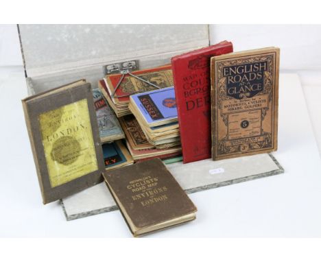


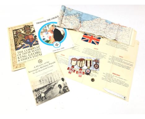
Lot 3183
British Red Cross medals to E.C.Halstead, West Riding, Proficiency in Nursing & First Aid, 5 years Service, WWll type pilots silk escape map and Central Europe instructions with compass and saw blade, and programmes for 1937 Coronation, 1966 Trooping the Colour, 1979 Sovereign's Birthday Parade Condition Report Click here for further images, condition, auction times & delivery costs


Lot 133
World War One (WW1) and World War Two (WW2) campaign medals - WW1: War medal and Victory medal, both inscribed to the rim J 80638 A E Lewin Boy 1 R.N.; WW2: 1939-1945 Star, Africa Star with North Africa 1942-43 bar and War medal, also awarded L.S.G.C. medal (missing) served latterly on HMS Avenger, Royal Navy, died on 15th November 1942 aged 41 years - included in lot report of sinking, map of Avenger, copy of service record and more

Lot 22
Official History of the Great War- Military Operations France and Belgium, 1914, Mons, the retreat to the Seine, the Marne and the Aisne, two volumes publ Macmillan, 1922, 32 maps plus plate - condition very good and clean, held in hinged faded red map boxes over stiff board with minor buckling [2]
Lot 243
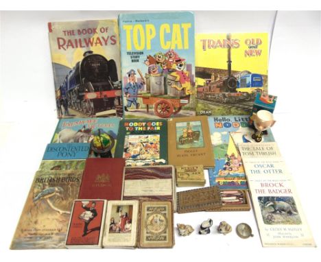
ASSORTED COLLECTABLES comprising an Ordnance Survey folding map of Windsor, circa 1900, red cloth covers; three packs of playing cards, including one of New Zealand and Federal Steamship Companies interest; three Wade ceramic figurines; pen nibs; various childrens books; a Fairylite 'Big Ears' egg cup, boxed; and other items.
![[BOOKS]. TOPOGRAPHY - WILTSHIRE Pitt-Rivers, Lieut.-Gen. King John's House, Tolland Royal, Wiltshire, privately printed, 189](https://cdn.globalauctionplatform.com/58f8c164-35d0-4282-8fda-abac010428c7/4eaa5b61-c208-4fd1-b3d5-abb30121c7d5/468x382.jpg)
![[BOOKS]. TOPOGRAPHY - SOMERSET Burrow, Edward. Ancient Earthworks & Camps of Somerset, subscriber's limited edition 574/](https://cdn.globalauctionplatform.com/58f8c164-35d0-4282-8fda-abac010428c7/45e36af0-d393-4c6d-a6e3-abb30121dffb/468x382.jpg)
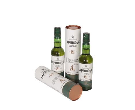
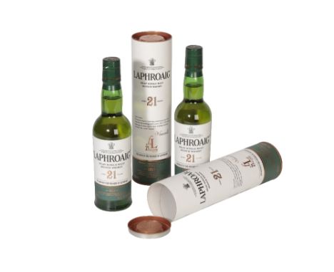
Lot 467
LAPHROAIG SINGLE MALT SCOTCH WHISKY, AGED 21 YEARS, limited edition release to celebrate the 21st anniversary of the Friends of Laphroaig, Isle of Islay, 35cl, 45.4% abv, in carton, 2 btls On the far edge of the Scotch whisky map, it's supposed that the art of distillation was first brought to Islay by Irish monks. Being remote, it's an art that flourished in the hands of the islanders, whose illegal operations tested the resolve and means of the tax man. Eventually, the law relaxed, various whisky makers set up legitimate distilleries, among them a pair of farmers, Donald and Alexander Johnston, who in 1815 founded their distillery on the island's south coast. Laphroaig, so called after its location, 'broad hollow by the bay.' It would remain in family hands for the next 139 years. Distilled in 1993, the year before the Friends of Laphroaig was founded, this whisky was maturing whilst the ranks of afficionados swelled to over 650,000 when bottled in 2015
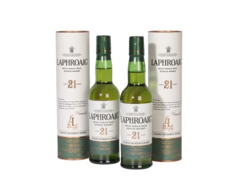
Lot 468
LAPHROAIG SINGLE MALT SCOTCH WHISKY, AGED 21 YEARS, limited edition release to celebrate the 21st anniversary of the Friends of Laphroaig, Isle of Islay, 35cl, 45.4% abv, in carton, 2 btls On the far edge of the Scotch whisky map, it's supposed that the art of distillation was first brought to Islay by Irish monks. Being remote, it's an art that flourished in the hands of the islanders, whose illegal operations tested the resolve and means of the tax man. Eventually, the law relaxed, various whisky makers set up legitimate distilleries, among them a pair of farmers, Donald and Alexander Johnston, who in 1815 founded their distillery on the island's south coast. Laphroaig, so called after its location, 'broad hollow by the bay.' It would remain in family hands for the next 139 years. Distilled in 1993, the year before the Friends of Laphroaig was founded, this whisky was maturing whilst the ranks of afficionados swelled to over 650,000 when bottled in 2015
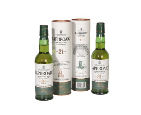
Lot 469
LAPHROAIG SINGLE MALT SCOTCH WHISKY, AGED 21 YEARS, limited edition release to celebrate the 21st anniversary of the Friends of Laphroaig, Isle of Islay, 35cl, 45.4% abv, in carton, 2 btls On the far edge of the Scotch whisky map, it's supposed that the art of distillation was first brought to Islay by Irish monks. Being remote, it's an art that flourished in the hands of the islanders, whose illegal operations tested the resolve and means of the tax man. Eventually, the law relaxed, various whisky makers set up legitimate distilleries, among them a pair of farmers, Donald and Alexander Johnston, who in 1815 founded their distillery on the island's south coast. Laphroaig, so called after its location, 'broad hollow by the bay.' It would remain in family hands for the next 139 years. Distilled in 1993, the year before the Friends of Laphroaig was founded, this whisky was maturing whilst the ranks of afficionados swelled to over 650,000 when bottled in 2015
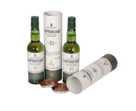
Lot 470
LAPHROAIG SINGLE MALT SCOTCH WHISKY, AGED 21 YEARS, limited edition release to celebrate the 21st anniversary of the Friends of Laphroaig, Isle of Islay, 35cl, 45.4% abv, in carton, 2 btls On the far edge of the Scotch whisky map, it's supposed that the art of distillation was first brought to Islay by Irish monks. Being remote, it's an art that flourished in the hands of the islanders, whose illegal operations tested the resolve and means of the tax man. Eventually, the law relaxed, various whisky makers set up legitimate distilleries, among them a pair of farmers, Donald and Alexander Johnston, who in 1815 founded their distillery on the island's south coast. Laphroaig, so called after its location, 'broad hollow by the bay.' It would remain in family hands for the next 139 years. Distilled in 1993, the year before the Friends of Laphroaig was founded, this whisky was maturing whilst the ranks of afficionados swelled to over 650,000 when bottled in 2015
Lot 471
LAPHROAIG SINGLE MALT SCOTCH WHISKY, AGED 21 YEARS, limited edition release to celebrate the 21st anniversary of the Friends of Laphroaig, Isle of Islay, 35cl, 45.4% abv, in carton, 3 btls On the far edge of the Scotch whisky map, it's supposed that the art of distillation was first brought to Islay by Irish monks. Being remote, it's an art that flourished in the hands of the islanders, whose illegal operations tested the resolve and means of the tax man. Eventually, the law relaxed, various whisky makers set up legitimate distilleries, among them a pair of farmers, Donald and Alexander Johnston, who in 1815 founded their distillery on the island's south coast. Laphroaig, so called after its location, 'broad hollow by the bay.' It would remain in family hands for the next 139 years. Distilled in 1993, the year before the Friends of Laphroaig was founded, this whisky was maturing whilst the ranks of afficionados swelled to over 650,000 when bottled in 2015
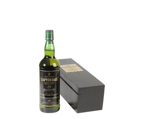
Lot 472
LAPHROAIG SINGLE MALT SCOTCH WHISKY, 25 YEAR OLD CASK STRENGTH, 2015 EDITION, Oloroso sherry and American oak casks, Isle of Islay, 70cl, 46.8% abv, in case On the far edge of the Scotch whisky map, it's supposed that the art of distillation was first brought to Islay by Irish monks. Being remote, it's an art that flourished in the hands of the islanders, whose illegal operations tested the resolve and means of the tax man. Eventually, the law relaxed, various whisky makers set up legitimate distilleries, among them a pair of farmers, Donald and Alexander Johnston, who in 1815 founded their distillery on the island's south coast. Laphroaig, so called after its location, 'broad hollow by the bay.' It would remain in family hands for the next 139 years.
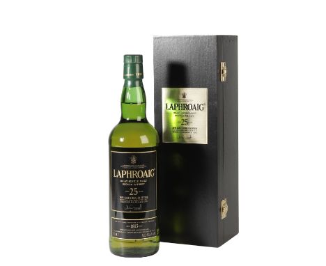
Lot 473
LAPHROAIG SINGLE MALT SCOTCH WHISKY, 25 YEAR OLD CASK STRENGTH, 2015 EDITION, Oloroso sherry and American oak casks, Isle of Islay, 70cl, 46.8% abv, in case On the far edge of the Scotch whisky map, it's supposed that the art of distillation was first brought to Islay by Irish monks. Being remote, it's an art that flourished in the hands of the islanders, whose illegal operations tested the resolve and means of the tax man. Eventually, the law relaxed, various whisky makers set up legitimate distilleries, among them a pair of farmers, Donald and Alexander Johnston, who in 1815 founded their distillery on the island's south coast. Laphroaig, so called after its location, 'broad hollow by the bay.' It would remain in family hands for the next 139 years.
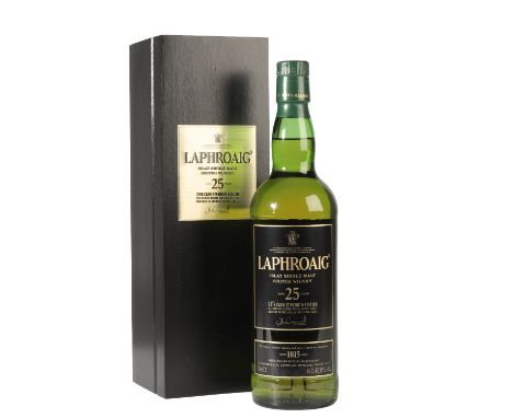
Lot 475
LAPHROAIG SINGLE MALT SCOTCH WHISKY, 25 YEAR OLD CASK STRENGTH, 2015 EDITION, Oloroso sherry and American oak casks, Isle of Islay, 70cl, 46.8% abv, in case On the far edge of the Scotch whisky map, it's supposed that the art of distillation was first brought to Islay by Irish monks. Being remote, it's an art that flourished in the hands of the islanders, whose illegal operations tested the resolve and means of the tax man. Eventually, the law relaxed, various whisky makers set up legitimate distilleries, among them a pair of farmers, Donald and Alexander Johnston, who in 1815 founded their distillery on the island's south coast. Laphroaig, so called after its location, 'broad hollow by the bay.' It would remain in family hands for the next 139 years.


Lot 644
C & J GREENWOOD: MAP OF THE COUNTY OF DORSET from an actual survey made in the years 1825 & 1826, engraved by H Frost and published by Greenwood, with a vignette of St Mary's Church, Sherborne lower left, a compass rose upper centre, the key upper right, the divisions lower right and the elabroately lettered title upper left, 63cm x 74cm Provenance: Lee Jackson Antique Maps and Engravings, London Private Collection, Cornwall


Lot 647
MICHAEL DRAYTON (1563-1631) ROBERT HOLE (d. 1624) 'Dorsetshere' a stylised map of Dorset, Western Hampshire and the Isle of Wight, with the characteristic anthropomorphic spirits of the rivers, settlements and other features of the land, created for Drayton's epic poetical work on the origins of Britain 'Poly-Olbion' hand-coloured engraving, 24.5cm x 32cm

Lot 648
JAN KIP (1652-1722) AFTER LEONARD KNYFF (1650-1722) 'Bryanstone in Dorsetshire, one of the seats of Henry Portman Esq.' from 'Britannica Illustrata' 35cm x 48.5cm; together with a map of Dorsetshire after Emmanuel Bowen (1694-1767), 42.5cm x 51cm; and a map of Gloucestershire after John Speed (1551-1629), 40cm x 52.5cm (3)

Lot 649
HOMANN HEIRS (HOMANNIANI/HOMANIANOS HEREDES) 'Tabula America Specialis Geographica Regni Peru, Brasilia Terra Firmae & Reg. Amazonum' engraved map with contemporary hand colouring depicting the northern section of South America, the sheet 57.5cm x 66cm; together with a similar map of the southern section of South Armerica 'Typus Geographicus Chili Paraguay Freti Magellanici & C', 57.5cm x 66cm; and another map of the northern section 'Carte de la Terre Ferme du Perou, du Brasil et du Pays des Amazones' after William Delisle (1675-1726), 69cm x 52cm (all unframed) (3)

Lot 656
C SAXTON DORSETSHIRE MAP," Described by C. Saxton, Corrected and Amended with many Additions as Roads & c by P Lea", 60cm x 48.5cm including the margins, together with one other map "Plan of the County of Dorset, Divided into Divisions..." dated "1803", 65cm x 54cm, edges stuck down, and handwritten " Dorsetshire plan of Arrangement, Entered into for the Defence of the County", listing various Captains, all contained in a modern folio


![[MISCELLANEOUS]. TOPOGRAPHY & OTHER Headlam, Cecil. The Inns of Court, first edition, Black, London, 1909, crimson cloth](https://cdn.globalauctionplatform.com/e64c5203-1910-4634-a16d-abac0103811c/238e521a-450f-4f66-a18e-abb1010b9dac/468x382.jpg)
Lot 108
[MISCELLANEOUS]. TOPOGRAPHY & OTHER Headlam, Cecil. The Inns of Court, first edition, Black, London, 1909, crimson cloth gilt, top edges gilt, twenty paper-protected colour plate illustrations by Gordon Home (including frontispiece, as called for), folding sketch-plan at end, 4 pp. publisher's catalogue, octavo; Nicholls, G.F. Cornwall, first edition, Black, London, 1915, grey cloth, twenty paper-protected colour plate illustrations by G.E. Mitton (including frontispiece, as called for), bird's eye view of Fowey Haven, sketch-map at end, octavo; and a further ten assorted volumes, all published by Black, (12).
![[MAPS]. SHROPSHIRE Moll, Herman (c.1654-1732), 'Shropshire', engraved map, hand-coloured, 31.5cm x 20cm, framed and glazed.](https://cdn.globalauctionplatform.com/e64c5203-1910-4634-a16d-abac0103811c/3c68c0b9-f406-43e1-b585-abb1010b9f95/468x382.jpg)
![[MAPS]. FRANCE Postel, Guillaume (1510-1581), & Ortelius, Abraham (1527-1598), 'Gallia', engraved map, hand-coloured, 36](https://cdn.globalauctionplatform.com/e64c5203-1910-4634-a16d-abac0103811c/2fd92bb1-ff33-4575-a010-abb1010ba357/468x382.jpg)
![[CHILDRENS] Milne, A.A. Winnie-the-Pooh, first edition, Methuen, London, 1926, dark green cloth gilt (corners knocked), top](https://cdn.globalauctionplatform.com/e64c5203-1910-4634-a16d-abac0103811c/a6084285-9b40-4c54-8354-abb1010b3dd9/468x382.jpg)
![[TOPOGRAPHY]. KENT & ESSEX Shore, W. Teignmouth. Kent, first edition, Black, London, 1907 (20s. Series), decorative gree](https://cdn.globalauctionplatform.com/e64c5203-1910-4634-a16d-abac0103811c/b7f557f9-1d35-4268-82f6-abb1010b7d19/468x382.jpg)
Lot 73
[TOPOGRAPHY]. KENT & ESSEX Shore, W. Teignmouth. Kent, first edition, Black, London, 1907 (20s. Series), decorative green cloth, top edges gilt, seventy-three paper-protected colour plate illustrations by W. Biscombe Gardner (including frontispiece, as called for), ground plan of Canterbury Cathedral and folding sketch plan of Canterbury (opposite p.116), folding sketch map (at end), quarto; and Moncrieff, A.R. Hope. Essex, first edition, Black, London, 1909 (20s. Series), decorative Vandyke brown cloth, top edges gilt, seventy-five paper-protected colour plate illustrations by L. Burleigh Bruhl (including frontispiece, as called for), folding sketch map (at end), 2 pp. publisher's list, quarto (one plate, opposite p.74, with paper-adhesion marks), (2).
![[TOPOGRAPHY]. SOMERSET Jeboult, Edward. A General Account of West Somerset, Description of the Valley of the Tone, and the H](https://cdn.globalauctionplatform.com/e64c5203-1910-4634-a16d-abac0103811c/84aa1a42-5c3b-47ab-b2e9-abb1010b802c/468x382.jpg)
Lot 76
[TOPOGRAPHY]. SOMERSET Jeboult, Edward. A General Account of West Somerset, Description of the Valley of the Tone, and the History of the Town of Taunton, Somerset & Bristol Steam-Press, Taunton, 1873, original blind-stamped brown-grey cloth, map frontispiece, thirteen mounted multi-view plate illustrations, author's approval slip to front pastedown, quarto (spine ends nicked and frayed; foxed); together with Views of the Quantocks, Whitby, Bridgwater, no date, green boards gilt, sixteen full-page illustrations from photographs, staple-bound, 17.25cm x 23.25cm, (2).
![[TOPOGRAPHY] Senior, W., et al. The Royal River: The Thames, from Source to Sea, Cassell & Co., London, no date [circa 1](https://cdn.globalauctionplatform.com/e64c5203-1910-4634-a16d-abac0103811c/4a63bcd9-b709-4d3b-93a4-abb1010b819a/468x382.jpg)
Lot 78
[TOPOGRAPHY] Senior, W., et al. The Royal River: The Thames, from Source to Sea, Cassell & Co., London, no date [circa 1885], pictorial bevelled blue cloth gilt, all edges gilt, full-page and text illustrations, map, tall quarto (upper hinge tender); and The Book of the York Pageant 1909, Ben Johnson & Co., York, 1909, original green cloth gilt, top edges gilt, frontispiece, colour and black and white plate illustrations, and text vignettes, quarto, in a plain card box (spine damp speckled; box with torn edging to lid), (2).
![[TOPOGRAPHY] Money, Walter. The History of the Ancient Town and Borough of Newbury, in the County of Berks, first edition, P](https://cdn.globalauctionplatform.com/e64c5203-1910-4634-a16d-abac0103811c/74b804f3-5036-4eed-b8c1-abb1010b8434/468x382.jpg)
Lot 81
[TOPOGRAPHY] Money, Walter. The History of the Ancient Town and Borough of Newbury, in the County of Berks, first edition, Parker & Co., Oxford & London, 1887, original brown cloth gilt (rubbed; spine ends nicked; joints partially torn), folding plan frontispiece (badly torn but without major loss), folding map, folding plan (both torn, without loss), 8 pp. publisher's list, large octavo; and Harper, Charles G. The Portsmouth Road and its Tributaries: To-day and in Days of Old, first edition, Chapman & Hall, London, 1895, pictorial blue cloth (rubbed), thirty-eight plate illustrations (including frontispiece, as called for), further text illustrations, octavo, (2).
![[TRAVEL]. INDIA Penny, F.E. Southern India, first edition, Black, London, 1914 (20s. Series), decorative orange cloth, fifty](https://cdn.globalauctionplatform.com/e64c5203-1910-4634-a16d-abac0103811c/887260c2-abe2-4049-9322-abb1010b85d2/468x382.jpg)
Lot 83
[TRAVEL]. INDIA Penny, F.E. Southern India, first edition, Black, London, 1914 (20s. Series), decorative orange cloth, fifty paper-protected colour plate illustrations by Lady Lawley (including frontispiece, as called for), folding sketch map (at end), 4 pp. publisher's list, quarto (one plate, opposite p.230, folded).
![[TRAVEL]. SOUTH AFRICA Kidd, Dudley. The Essential Kafir, first edition, Black, London, 1904, decorative black cloth, top ed](https://cdn.globalauctionplatform.com/e64c5203-1910-4634-a16d-abac0103811c/695a1606-fd45-446b-b949-abb1010b86d4/468x382.jpg)
Lot 84
[TRAVEL]. SOUTH AFRICA Kidd, Dudley. The Essential Kafir, first edition, Black, London, 1904, decorative black cloth, top edges gilt, one hundred plate illustrations from photographs by the author (including frontispiece, as called for), folding map (at end), errata slip, 4 pp. publisher's list, quarto (corners knocked).
![[TRAVEL]. A. & C. BLACK 7s. 6d. SERIES Bell, Mrs Arthur. Nuremberg, first edition, Black, London, 1905, decorative blue](https://cdn.globalauctionplatform.com/e64c5203-1910-4634-a16d-abac0103811c/baaea999-41c6-4e17-b690-abb1010b87ce/468x382.jpg)
Lot 85
[TRAVEL]. A. & C. BLACK 7s. 6d. SERIES Bell, Mrs Arthur. Nuremberg, first edition, Black, London, 1905, decorative blue cloth gilt, top edges gilt, twenty paper protected colour plate illustrations by Arthur Bell (including frontispiece, as called for), 4 pp. publisher's list, octavo; Dobson, G. St. Petersburg, first edition, Black, London, 1910, decorative yellow cloth, top edges gilt, the title blind-stamped 'Presentation Copy', sixteen paper protected colour plate illustrations and sixteen black and white plate illustrations by F. De Haenen (including frontispiece, as called for), folding map (at end), octavo; and Grove, H.M. Moscow, first edition, Black, London, 1912, decorative blue cloth gilt, top edges gilt, sixteen paper protected colour plate illustrations and sixteen black and white plate illustrations by F. De Haenen (including frontispiece, as called for), folding plan (at end), octavo; together with Stewart, Hugh. Provincial Russia, first edition, 1913; Gribble, Francis. Geneva, first edition, 1908; Musson, Spencer. La Cote d'Emeraude, first edition, 1912; Musson, Spencer. Around St. Malo, first edition thus, 1917; and Mackenzie, W.M. Pompeii, first edition, 1910, (8).
![[TRAVEL]. INDIA Buck, Edward. Simla Past and Present, first edition, Thacker, Spink & Co., Calcutta, 1904, original pict](https://cdn.globalauctionplatform.com/e64c5203-1910-4634-a16d-abac0103811c/7dbe1d77-cccb-49a8-bd9c-abb1010b88cc/468x382.jpg)
Lot 86
[TRAVEL]. INDIA Buck, Edward. Simla Past and Present, first edition, Thacker, Spink & Co., Calcutta, 1904, original pictorial bevelled green cloth, decorative endpapers, frontispiece and a further fifty plate illustrations (as called for), folding map, large octavo (spine and peripheries faded and browned; spine blocking visible as uncoloured faint impression only; small hole to lower joint; corners bumped).
![[TRAVEL]. INDIA Mundy, Captain. Pen and Pencil Sketches, being The Journal of a Tour in India, two volumes, Murray, London,](https://cdn.globalauctionplatform.com/e64c5203-1910-4634-a16d-abac0103811c/43cc76a9-7123-4f10-a01c-abb1010b8a3a/468x382.jpg)
Lot 88
[TRAVEL]. INDIA Mundy, Captain. Pen and Pencil Sketches, being The Journal of a Tour in India, two volumes, Murray, London, 1832, half green calf, the spines in compartments with crimson title labels, seventeen plate illustrations (12 + 5, as called for), folding map (at end of volume one), octavo (spine strips torn, with losses and glue repairs; joints cracked; vol. 1 lacking volume label and with almost detached lower board).
![[TRAVEL]. INDIA Gleig, Rev. G.R. The Life of Major-General Sir Thomas Munro, Bart. and K.C.B., Late Governor of Madras, new](https://cdn.globalauctionplatform.com/e64c5203-1910-4634-a16d-abac0103811c/94529a70-3957-4fc8-8f6c-abb1010b8ce5/468x382.jpg)
Lot 90
[TRAVEL]. INDIA Gleig, Rev. G.R. The Life of Major-General Sir Thomas Munro, Bart. and K.C.B., Late Governor of Madras, new edition, two volumes, Colburn and Bentley, London, 1831, full calf, tissue-guarded engraved portrait frontispiece, folding map, octavo (spine head upper compartments torn, that of vol. 1 with glue repair; vol. 1 with cracked joints; map torn, without loss but with paper tape repair).
![[TRAVEL]. MEXICO Stephens, John. Incidents of Travel in Yucatan, first edition, two volumes, Murray, London, 1843, original](https://cdn.globalauctionplatform.com/e64c5203-1910-4634-a16d-abac0103811c/b03d318e-3211-4e9e-a7df-abb1010b8fbe/468x382.jpg)
Lot 93
[TRAVEL]. MEXICO Stephens, John. Incidents of Travel in Yucatan, first edition, two volumes, Murray, London, 1843, original brown cloth gilt, 124 plate and text illustrations (including frontispieces, as called for), with two further unlisted illustrations in volume two (a plate opposite p.290 and a diagram on p.342), folding map, 4 pp. publisher's list for T. & W. Boone in French and English, octavo (spines worn, with 55% loss to spine strip of vol. 2; vol. 2 frontispiece torn with major loss; plates with heavily browned tissue guards; foxed; vol. 1 pp.17-20 detached; vol. 2 with duplicate copies of pp.133-144 and plate opposite p.134).

Lot 242
Banksy (British 1974-), 'Selection Of Banksy Ephemera', a collection of Banksy works to included; 'Di-Faced Tenner', 'Peckham Rock' postcard, 'Banksy vs Bristol Museum' guide and sealed postcard set, 'Crude Oils' sealed postcard set and single 'Kate Moss' postcard, 'Banksy In New York' (1st Edition, numbed from an edition of 2000), Dismaland guide, map and 'Fish Finger' (Q) ARR


Lot 711
Militaria, Escape Map, Sheet J3/J4. Double sided black, white, red and green silk/rayon escape map, approximately 50 x 65m. 1 : 378,000. J3 covers Northern & Central Italy, the Swiss and Austrian border and has a enlarged section of the Swiss frontier (slightly faded, some foxing and some small holes)

Lot 799
Maps, 28 OS maps of Berkshire, Hampshire, Surrey and Middlesex printed in the 1940s and 50s, a London Routes Coronation Day map, a Philips' New Railway Map of London & District and other sundry maps (gen gd). Sold together with a Messenger & Co. Ltd. Fifth Edition Glasshouse and Conservatory catalogue circa 1900 (fair/gd) (29)

Lot 16
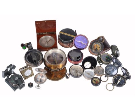
A collection of pocket sighting compasses, inclinometers and other related instrumentsVarious makers, late 19th century and laterComprising a French compass with silvered two-piece dial divided for every degree to circumference set within a folding square mahogany case, 8.5cm (3,375ins) wide; an unsigned oxidised brass surveyor's compass with floating silvered scale divided into half degree increments to outer track beneath hinged prism magnifier and pivoted filters opposing crosshair sight backed by a hinged mirror, with circular snap-on cover, 7.5cm (3ins) diameter; five various military issue sighting compasses, 6cm (2.375cm) wide and smaller including one in a leather pouch-type case; a circular oxidised brass perpendicular sight stamped STANLEY, LONDON 5.1cm (2ins) diameter, in red leather case similarly signed to interior, and a circular oxidised brass WATKIN MIRROR CLINOMETER by J. HICKS,MAKER, 8 HATTON GARDEN, LONDON further inscribed REG 14 MAR 1881, 7cm (2.75ins) diameter, in leather case, together with five assorted pocket compasses and a brass folding map magnification lens stamped CASARTELLI, MANCHESTER, (15).


Lot 523
A medal and associated ephemera collection from the estate of Charles Frederick Motley RN. Comprising War Medal 1939-45, Naval General Service Medal 1915-62 (with clasps for Cyprus, Near East, Malaya and Palestine), Korea Medal, UN Korea Medal, General Service Medal 1962- (with Malay Peninsula clasp), 1977 Jubilee medal and Long Service Good Conduct Medal (MX.817137 CPO CK (S) HMS Tiger), together with an UNVERIFIED Air Force Cross (dated 1955) & MBE Military 2nd type, a set of ?duplicate copy? medals and set of corresponding miniatures, Queen?s Golden Jubilee Medal, (Japan Occupational Forces 1946-52 medal) (see images and refer to auction department), Royal Navy Pilots Log Book (1946) Rating Pilot IV Class, large photograph/scrap album containing many monochrome photos from naval tours, mess dinners, guest visitors etc, hand delineated, also mounted postcard and souvenirs, instructions and ?thank you? letters for Queen Mother?s dinner, numerous wedding cakes, boxed piece of the 1981 Wedding Cake of HRH PoW and Princess Dianaand other catering achievement ephemera, large ring-binder containing certificates, Admiralty Letters of Appointment etc including a Bryant & May?s box of Safety Matches containing a secret escape map and two postcard albums with various Royal Navy ships, bases, and the village of Ingoldsby where Charles Frederick Morley was born. C.F. Motley had a unique naval career, enlisting in RN Fleet Air Arm in 1945 and gaining his wings before moving to catering in the Royal Navy, where he served on over 30 ship various carriers, and was head of Catering School in Chatham when they were commissioned to produce the wedding cake for HRH Prince of Wales and Lady Diana Spencer in 1981. C.F. Motley later gained his Submariner ?Dolphins? which were worn together with his Wings on uniform. (see images)

Lot 616
John Speed, double-sided hand coloured map of 'Wight Island' with 'An Alphabeticall Table of all the Townes' verso, mounted, glazed and framed, approx. 39 x 51cm, together with two maps of Hampshire by Robert Morden, map of London to Gosport and a miniature hand coloured map of Hampshire (5)

-
109198 item(s)/page