We found 109182 price guide item(s) matching your search

Refine your search

Year

Filter by Price Range
  • List
  • Grid
  • 109182 item(s)
    /page

Lot 258

A leather suitcase initialled AMG and contents including cigarette cards and Daily Express War Map of All Fronts

Lot 117

A reproduction map of Lancashire

Lot 2045

Six HMSO Training Manuals published for the War Office including Elementary Map Reading 1941, WO code 7960, Hints on Map Reading Instruction 1943, Drill (All Arms) 1951 -WO code 8510, Cadet Training Vol 1 1956 - WO code 9035 and two copies of Cadet Training Vol II 1956 - WO code 9036.

Lot 2077

A box of assorted pictures and Prints, including a map of Suffolk, map of Monmouthshire, etc.

Lot 2120

An Oil on canvas depicting a Vase of flowers, unsigned size 16 1/2'' x 20 1/2'', a Watercolour of flowers and a framed Map of Hampshire

Lot 569

Three boxes of assorted childrens games and toys to include Waddingtons Cluedo, the New Map Game Motorcross Motor Chase across London

Lot 617

18th century engraved map of Austria (with losses), the full sheet 54 x 60cm

Lot 649

An 18th century engraved county map of Suffolk for J Harrison, Newgate Street 1790, later hand-coloured, 33 x 47cm

Lot 656

Robert Morden - Engraved county map of Hertfordshire, later hand-coloured, 38 x 43cm

Lot 666

An engraved county map of Huntingdonshire; and two others of the same county (3)

Lot 672

An engraved county map of Northumberland; an engraved town plan; and a topographical print from the Illustrated London News (3)

Lot 248

A reproduction map reader compass, in a fitted case, 11cm, together with a small telescope

Lot 357

A map of Essex, framed, together with Laurel and Hardy figures, a box of china and cutlery

Lot 1124

A Map of Herefordshire 10 1/2'' x 8'', a Map of Leicestershire 10 1/2'' x 8'' and a large Map of Russia, 17 1/2'' x 14''

Lot 1202

A framed Print of a Saxton's Map of Yorkshire/Derbyshire, 21'' x 17'' together with a framed Print of a Map of Lincolnshire, 19 1/2'' x 15 1/2''.

Lot 44

A Robert Morden map of Hertfordshire and three other pictures

Lot 308

Oak banjo barometer/thermometer, 28" high; together with an antique style map of Gloucestershire, framed (2)

Lot 130

A map of Rutland, with Oakham and Stanford, by Speede, 16ins x 20ins

Lot 131

An Antique road map, Hereford to Leicester with map of Leicestershire, framed and glazed front and back, 7.5ins x 4.75ins

Lot 252

Henrietta Fanshawe, mosaic, map of Malta with figure in apron, 10ins x 15ins

Lot 178

Cigarette Cards, Cycling, Sectional Cycling Map by Ogden's (gd)

Lot 64

Pictures and Prints - various, Pollyanna Pickering; S Lewis map of Herefordshire; oils; etc

Lot 82

Ephemera - various, cigarette cards; a War Office Edition map; correspondence; interesting bills and invoices; etc

Lot 428

JOAN BLAEU NOTTINGHAMSHIRE double page engraved map with margins, hand coloured, 38 x 48.5cm and twelve other 18th and 19th c maps and prints of Nottingham (13) ++As a collection in good condition

Lot 429

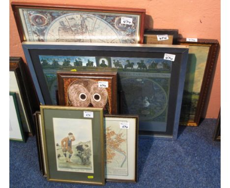
JOHANNES KIP (1653-1722) AFTER LEONARD KNYFF (1650-1722) THE PROSPECT OF NOTTINGHAM FROM YE EAST double page engraving mounted to platemark, hand coloured, 34.5 x 48cm and six other 18th and early-mid 19th c prints of Nottingham including a map (7) ++The Kypp engraving browned but still colourful, the others in reasonably good condition

Lot 380

Robert Morden, Kent circa 1695, 35 x 63.5cm, John Carey, A Map of Kent, The Best Authorities, circa 1805, 37 x 54cm, and another map of Kent

Lot 390

Kitchen Thomas, Kent drawn from an Actual Survey, circa 1740, engraving, flanked by period and later pages titled 'General Description of the County of Kent', framed as one, map 17.5 x 22.5cm, a miniature map of Kent, circa 1820, with four book pages, also framed as one, and two other maps of Kent

Lot 71

Latrobe (C.I. Rev.) A Journal of a visit to South Africa, with some account of the missionary settlements of the United Brethren, near the Cape of Good Hope second edition, folding engraved map handcoloured in outline and 3 engraved plates, tissue guards, contemporary half calf over patterned boards, lacks top board, 8vo, 1821.

Lot 74

Elstobb (W.). An Historical Account of the Great Level of the Fens, called Bedford Level ....., folding engraved map, list of subscribers, contemporary calf, ruled in gilt, rebacked with original spine skillfully laid down, [Kress B 2500, Goldsmith 15577], 4to, Lynn, W Whittingham, 1793.

Lot 76

Richards (William). The History of Lynn, 2 vol., folding map and 15 engraved and tinted plates, contemporary tree calf, spine gilt, rebacked with spine skillfully laid down, [Abbey 179], 4to, Lynn, W.G.Whittingham, 1812.

Lot 80

General View of the Agriculture of Lincolnshire ...., second edition, folding engraved frontispiece map, hand coloured, two folding engraved hand coloured maps, and eleven engraved plates, including one extra, several cropped close, original publisher's boards, uncut, 8vo, 1808.

Lot 83

Bailey (Robert S.). Natiae Ludae or Notices of Louth, folding engraved map, engraved title vignette, five engraved plates, the one with tisssue guard; uniform browning, contemporary half sheep over publishers boards, Louth, 1834, 8 vo.

Lot 92

Turnor (Edmond). Collections for the history of the town and soke of Grantham .... hand coloured engraved map frontispiece and seven engraved plates, plate of Johannus De Welby stain glass window with tissue guard from another work loosly inserted, later half moroccoed over patterned boards, spine ends worn, folio, 1806.

Lot 99

Weir (George). Historical and Descriptive Sketches of the Town and Soke of Horncastle ....., folding engraved map, hand coloured map, and five engraved plates with tissue guards, cloth-backed boards, 8vo, 1820.

Lot 316

Walker (Neil). The History of Wisbech and the Fens, engraved frontispiece, folding engraved map and 16 engraved plates, contemporary half calf over patterned boards, scuffed at extremities, 4to, Wisbech, 1849.

Lot 430

Lincolnshire.- White (William). History Gazetteer A Directory of Lincolnshire..., lacking map, contemporary calf, 8vo,1842; Baines (Edward), History, Directory and Gazetteer of the County of York ..., lacking maps, contemporary calf, worn, 1822; and a small quantity of other items mainly relating to Lincolnshire, with a 1934 Kelly's Directory of Kent, Surrey and Sussex, (qty).

Lot 258

A framed & glazed 19th century Henry Teesdale hand coloured map of Rutland. Frame size 50 x 58cm

Lot 1026

An Ordnance Survey map of Herefordshire, linen backed together with London's Country Guide No.1

Lot 1096

Robert Morden map of Warwickshire

Lot 1103

A set of framed Player's cigarette cards 'Fire Fighting Appliances', a map of Norfolk, two scrap books containing articles and pictures of 'The Times' 1928-1929 and 1929-1931 to include ocean liners, trains etc, a quantity of colour book pages

Lot 1131

A large collection of prints including scenes of Scotland, Wales and England. Also includes a large collection of Cathedral prints and various machines. Also includes a map of the diocese of England and Wales and a Genealogical Handbook of English History

Lot 1146

An 1890 OS map of The Country Around Minchinhampton

Lot 1149

Kelly's map of London and suburbs

Lot 804

A 19th century map of 'Ireland' coloured engraving, published by the Society for the Diffusion of useful knowledge, 1838, 60cm by 48cm and another map of 'The County of Kent', published by Chapman and Hall, 20cm by 25cm.

Lot 833

A 17th century map of The Kingdome of England by Abraham Goos Amsteloda, dated 1646, showing the counties of England and Wales, 51cm by 39cm, in double glazed frame, the verso England's Generall Description

Lot 177

Great Britain - 1969 (1 July) Investiture Prince of Wales with Caernarvon special handstamp, very unusual, t/a. With Wales map as illustration.

Lot 364

Great Britain & Norway - 1980 (20 June) Gunnar Nilsson Cancer Campaign pair of covers. Signed, expedition map on covers, l/a.

Lot 344

12 Various prints and engravings and a map of Somerset

Lot 573

Robert Morden maps of Buckinghamshire and Berkshire another map and two pictures

Lot 474

Group of assorted furnishing pictures, maps, framed ceramic tiles, needlepoint map of England and Wales, print after Constable etc. (10)

Lot 387

John Ogilby, a rare hand coloured road map, Salisbury to Campden, circa 1675, from the John Ogilby Britannia Road Atlas. H.47cm W.35cm

Lot 418

MICHAEL BURDLE: A map of Weymouth showing historic buildings, white ink on black paper

Lot 398

ROBERT MORDEN: 'Map of Dorsetshire', together with Kitchin's Map of Gloucestershire

Lot 115

A Framed Reproduction Blaeu Map of Scotland.

Lot 200

Three Pocket Watches and A Map Measuring Wheel.

Lot 396

Avery hand coloured shipping map of the Isle of Wight, framed

Lot 112

A large map reader style compass in wooden box

Lot 144

John Speed (1552-1629): A map of Herefordshire, hand coloured; together with an 18th century print of Carmarthen Castle (2)

Loading...Loading...
  • 109182 item(s)
    /page

Recently Viewed Lots