

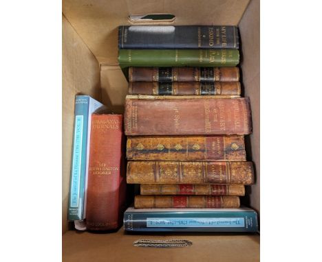
Late 19th and early 20th century tour guides. Nine works. Walter H. Tregellas. 'Tourists Guide to Cornwall and The Scilly Isles,' fifth edition, gilt embossed cloth, later uniform library dj, small tear to engraved fold out map, spotting to edge of text block, pp.160, pp.40 of advertisements to rear, vg, Edward Stanford, London, 1887; 'Weighell's Guide to North Cornwall with Map and Illustrations,' fifth edition, original cloth with gilt title to front board, contemporary ink owner inscription to front pastedown William Blackmore, small tear and repair to good fold out map, plates, pp.95, nine leaves of advertisements to rear, a very good copy, W. Weighell, Launceston, [c.1900]; Annie E. Argall. 'Tourists Guide to Cornwall and The Scilly Isles,' original embossed cloth with gilt tooled lettering to front board with differing title 'Netherton & Worths Tourist Guide to Cornwall', fine fold out map to frontis, charming steel engraved headpieces, advertisements, pp. 109, vg to fine, Netherton and Worth, Truro, 1900; C. S. Ward. 'North Devon and North Cornwall,' eighth edition, gilt embossed original cloth, colour fold out maps throughout, vg, Dulau & Co, London, 1904; 'Lake's Handy Guide Books to Cornwall. From Land's End to The Lizard,' torn and loss to printed thin card wraps, later dj, vg fold out map, steel engraved plates, slight spotting to edge of textblcok, advertisements, good, Lake and Lake, Truro, 1893; With three Murray's guides one being for Devon and a second edition Arthur L. Salmon. (9)A very good collection. John Stengelhofen (1939-2020). Please see lot 1 for provenance.
We found 109198 price guide item(s) matching your search
There are 109198 lots that match your search criteria. Subscribe now to get instant access to the full price guide service.
Click here to subscribe- List
- Grid
-
109198 item(s)/page

(Arctic exploration) D. Murry Smith 'Arctic Expeditions from British and Foreign Shores from the Earliest Times to the Expedition of 1875-76,' Full brown leather with gilt decorations, thick bevelled boards, rubbed mostly to extremities, gilt edge, frontis, full plates and fold out map, some sporadic spotting but generally a vg copy, Thomas Liddell. Glasgow, Melbourne, and Sydney, 1877.

A collection of OS maps and admiralty charts. All rolled, including;Admiralty Chart, 1930, “Chine Sea, Northern Portion–Eastern Sheet” showing Philippine Islands, addressed to B.Ong, Tehidy Hospital; OS 6’ 1977, two sheets joined together, showing boundaries of (?) something stretching between Horse Rock, Portreath and Trevellas; 1912, Geological Survey of Scotland, mineral veins and workings of Leadhills and Lanarkshire; OS 6’ 1906, Devils Bridge, Aberystwyth, Wales; OS 6’ 1906, adjoining map, Llanbadarn, Aberystwyth; OS 6’ 1977, Copy of map showing boundaries of Wheal Concord, Blackwater, Skinners Bottom, drawn & signed Hosking; Admiralty Plan, 1963, Falmouth Harbour & Truro River; Admiralty Plan, 1962, Mevagissey, Par, Charlestown and Looe Harbours; Admiralty Plan, 1931, “Plans of the North Coast of Devon and Cornwall” St Ives to Ilfracombe Harbour, incl Stevn Stones. From the estate of Ron Hooper, M.V.O., A.C.S.M., F.I.M.M.Born in St.Agnes, he graduated from Camborne School of Mines. After a short career mining in the Gold Coast of Ghana he joined the Camborne School of Mines, eventually becoming Senior Lecturer in Surveying. At the same time, he acted as an independent mining engineer and was appointed mineral agent for several Cornish estates including the Duchy of Cornwall, Tregothnan, and the Godolphin Estate (amongst others).
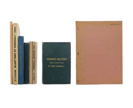
Cornish directories. Five works. R. Symons. 'A Geographical Dictionary or Gazetteer of the County of Cornwall,' original red cloth with bevelled boards and gilt tooled lettering, later uniform library dj, front board loosening, prelims debound, tape repairs to verso of fold out map, some light spotting to margins throughout, good to very good, F. Rodda, Penzance, 1884; John Wallis. 'The Cornwall Register; Containing Collections relative to the Past and Present State of the 209 Parishes....,' original green cloth vg, later dj, some spotting to edges of text block and prelims, good, Liddell and Son, Bodmin, 1847; 'Venning's Postal Directory of East Cornwall, 1887,' original green cloth, copious advertisements, fold out map, numerous engravings, good to very good, pp.228, 1847; 'The Cornwall Directory. Blue Book, 1929,' original blue cloth with gilt lettering, vg, Plymouth Printers, 1929; With a directory of Places for the Fire Brigade. (5)John Stengelhofen (1939-2020). Please see lot 1 for provenance.

Richard Warner 'A Tour Through Cornwall, in the Autumn of 1808,' Later uniform library dj taped to original boards, some toning, lacks frontis, pages uncut, good to vg, Richard Cruttwell, Bath, 1809; Walter White. 'A Londoner's Walk to the Land's End; And a Trip to the Scilly Isles,' original embossed cloth lacking backstrip, spotting throughout, fold out map, fair to good, Chapman and Hall, London, 1855; With six other works including Lewis Hind, Vulliamy, Wade and Hocking. (8)John Stengelhofen (1939-2020). Please see lot 1 for provenance.
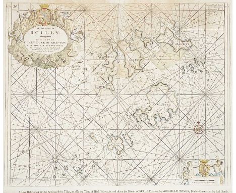
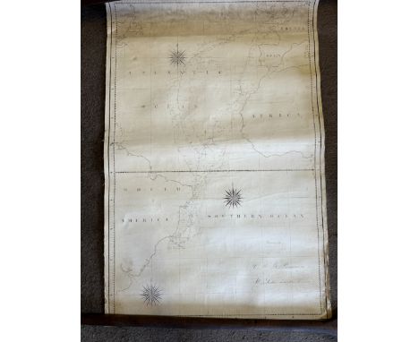
GREENVILE, Captain Collins Sea Chart of the Islands of Scilly Engraved and printed on laid paper, with pictorial cartouche dedication to the Duke of Grafton by title, later hand tinting to coastlines and pictorial areas, slight tear to top of centre fold, patchy toning, description by Abraham Tovey covered by mount, framed and glazed measuring 66cm x 76cm, good to very good, [c.1693].The first chart is the first printed map devoted to the islands (Quixley and Quixley, p.69).
'Trenwith Mine, St Ives,' Surveys and maps by Leonard Hawkey, 1911. Hand drawn cross sectional survey on thin linen by L. Hawkey, scale 1 inch to 5 fathoms, showing Victory Shaft, Berriman Shaft and Old Sump Shaft, reference of Adit Level, damp staining to edges, colour ink offsetting, rolled, approx 75cm x 215cm, 1911; 'Longitude Section', scale 1 inch to 5 fathoms, damp staining and nibbles to edge, rolled, approx, 75cm x 220cm [L. Hawkey, 1911]; Handrawn map on linen, with scale and compass, showing mine burrows, Stennack Road and Trenwith Terrace, damp staining, rolled, approx, 65.5cm x 143cm, [L. Hawkey, 1911], '....Berriman Shaft, Transverse Section,' hand drawn, scale 1 inch = 30 feet or 5 fathoms, damp staining to edges, approx 56cm x 21cm on much larger thin linen, rolled, [L. Hawkey, 1911]; With the same for 'Old Sump Shaft' and 'Victory Shaft'; Hand drawn survey both transverse and longitudinal sections for 'East Virgin Shaft and Sump Shaft', on linen with damp staining to edge, rolled, approx 68cm x 100cm, [L. Hawkey, 1911]; 'St Ives. Ordnance Map to show Leases and accompany Report of October 8th 1907,' tears and nibble to edges, rolled, approx 88cm x 109cm. (8)Surveyed by Hawkey during the reopening of the mine, by the German-owned 'British Radium Company' for the extraction of uranium (and radium). A fascinating survivor of subterranean St. Ives. From the estate of Ron Hooper, M.V.O., A.C.S.M., F.I.M.M.Born in St.Agnes, he graduated from Camborne School of Mines. After a short career mining in the Gold Coast of Ghana he joined the Camborne School of Mines, eventually becoming Senior Lecturer in Surveying. At the same time, he acted as an independent mining engineer and was appointed mineral agent for several Cornish estates including the Duchy of Cornwall, Tregothnan, and the Godolphin Estate (amongst others).

St Day Composite map 1:2500 showing geological contact, adits, Gossan, shafts (vertical), shafts (inclined), underground adits, drifts, cross-cuts, stopping, surface diamond drill holes, property boundaries St Day to Mount Wellington; Continuation to Tolgullow and Wheal Jane; 1:2500 Tracing, plan of mines in Scorrier District by RCAH; OS 25’ 1880, Tracing, Wheal Pink, St Day; 1772 Photcopy, map of boundaries of St Day (three parts); OS 25’ 1908, Great Wheal Busy &Chasewater;OS 6’ 1908, Redruth,Chasewater, St Day;OS 25’ 1908, United Mines St Day;Plan of Great County Adit,S.Furge;OS 25’ 1908, Wheal RoseScorrier;1892, 1:12672, Photocopy, Camborne,Illogan, Redruth &Gwennep Mines;OS25’ 1908, Mount Ambrose,Trefula, St Day;OS 25’ 1908,Poldice,Goongumpas, Hale Mills;WhealGorland, Wheal Quick, Wheal Cupid, maps, lodes & cross courses;Maps, lodes & cross courses,Scorrier, WestPoldice, Wheal Busy,Treskerby,North Downs;Maps, lodes, Park-an-Chy, North Downs, From the estate of Ron Hooper, M.V.O., A.C.S.M., F.I.M.M.Born in St.Agnes, he graduated from Camborne School of Mines. After a short career mining in the Gold Coast of Ghana he joined the Camborne School of Mines, eventually becoming Senior Lecturer in Surveying. At the same time, he acted as an independent mining engineer and was appointed mineral agent for several Cornish estates including the Duchy of Cornwall, Tregothnan, and the Godolphin Estate (amongst others).

Charts, Surveys, and maps. Map of West Africa, scale 1/3.000.000; Geological chart of Rio de Oro, Algerie; Survey of Wheal Grenville Mine, scale 1:500; five geological charts covering West Africa; 'Bathurst (Banjul)' sheet 10, coloured map, 1963; 'Westor Mine Ltd. No.4 Sheet,' scale 1:500 feet; Two charts profuse in illustrations regarding mining; 'Plan of Reef Plan'; With many other plans and charts in including second edition 1908 OS maps of Levant Mine &c. &c. From the estate of Ron Hooper, M.V.O., A.C.S.M., F.I.M.M.Born in St.Agnes, he graduated from Camborne School of Mines. After a short career mining in the Gold Coast of Ghana he joined the Camborne School of Mines, eventually becoming Senior Lecturer in Surveying. At the same time, he acted as an independent mining engineer and was appointed mineral agent for several Cornish estates including the Duchy of Cornwall, Tregothnan, and the Godolphin Estate (amongst others).

Cornwall. Geological Maps. 1:100 Holman Test Mine, Troon (partial), for UKAEA; 1:500 Holman Test Mine, underground (complete); 1’ Geological Survey Map, Tavistock; 1’ Geological Survey Map, Teignmouth; 1’ Geological Survey Map, Ivybridge; 1’ Geological Survey Map, Penzance, Hayle; 1’ Geological Survey Map, Falmouth; 1’ Geological Survey Map, Newquay; 1’ Geological Survey Map, Penzance, Hayle; 1’ Geological Survey Map, Camelford; 1’ Geological Survey Map, Exmoor, North Devon; OS 6’ 1908, Edition Map, Marazion; 1’ Geological Survey Map, Falmouth; 1’ Geological Survey Map, Tavistock; 1’ Geological Survey Map, Camelford. From the estate of Ron Hooper, M.V.O., A.C.S.M., F.I.M.M.Born in St.Agnes, he graduated from Camborne School of Mines. After a short career mining in the Gold Coast of Ghana he joined the Camborne School of Mines, eventually becoming Senior Lecturer in Surveying. At the same time, he acted as an independent mining engineer and was appointed mineral agent for several Cornish estates including the Duchy of Cornwall, Tregothnan, and the Godolphin Estate (amongst others).

A large collection of plans, OS maps, graphs &c. &c. Including;1981,Survey & Site plans by RCAH of Glebe Cottage, Comford, Lanner; Various graphs, metal production, prices by metal and country; Facsimilie liear map of 'Excelsior Tunnel. Kit Hill'; 'Southern Part of Devon Great Consols Mine'; 'International Mine Services. Plan and Section (Profile) of Diamond Drill Holes on the Plantation Vein'; 'I. M. S. Prince of Wales Development'; 1817 Copy of a drawing of Gunnislake and Lodes, plus underground workings; Geological projections &c. &c. (Q) From the estate of Ron Hooper, M.V.O., A.C.S.M., F.I.M.M.Born in St.Agnes, he graduated from Camborne School of Mines. After a short career mining in the Gold Coast of Ghana he joined the Camborne School of Mines, eventually becoming Senior Lecturer in Surveying. At the same time, he acted as an independent mining engineer and was appointed mineral agent for several Cornish estates including the Duchy of Cornwall, Tregothnan, and the Godolphin Estate (amongst others).


(Caroline Fox and Davies Gilbert) Royal Cornwall Polytechnic Society. A granderised collection of the first reports thought to be Caroline Fox's own. First annual report 1833 to the fifth annual report 1837, in one volume, with extra bound in letters, original sketches, plans, architectural drawings, etc, full pebbled red calf, rubbed to extremities and joints, 4to, gilt edge, vg, Jane Trathan, Falmouth, 1833-1837.First bound letter (MS) with the title "First Prospectus of the Falmouth Polytechnic Society, in the Spring of 1832" detailing the society's aims and objectives, with a list of lead members; this appears to be in the hand of Davies Gilbert himself, using examples from the Science Museum, the close top of the capital 'I' for instance, and the angularity of the lower case letters firmly suggest it is, without it being signed; Followed by (as a frontis) an original ink and wash portrait of Davies Gilbert and indeed flat signed by Gilbert.'Report of the Cornwall Polytechnic Society 1833,' List of Members, Laws of the Society, proceedings of the General Meeting, bound in watercolour sketch of a Cornish mine, an ink and wash sketch of 'Loss of the Prince of Wales, 1804', ink sketch 'Park of Whitby Abbey', prizes awarded, watercolour still life of flowers initialled RJ 1833, list of subscribers, watercolour plan of a greenhouse, Chart of Gothic Architecture, ink and wash sketch titled 'A Method of Ventilating Mines'.'The Second Annual Report of the Cornwall Polytechnic Society 1834,' watercolour portrait of a bearded man with a large ruby on his hat, 'A Mineralogical Sketch of the Island of Banca' (Bangka Island, Indonesia), a ground plan of Ashfield estate, engraving of a Dipping Needle Deflector, ink sketch of a Hydrostatic Lock, ink and watercolour chart on Cornwall, engravings of the 'Cheese Wring' in Bodmin, engraving of The Royal Academy Medal 1837.'The Third Annual Report of the Royal Cornwall Polytechnic Society 1835,' ink sketch of the Polytechnic medal, ink sketch of Laocoon and Sons, watercolour Jack Knife, , engraving of a ruined abbey, engraved portrait, watercolour coastal scene, ink sketch of capital punishment in a schoolroom, 'Lines of equal magnetic inclination' map of the Uk and Ireland, 'Two Treaties on the Natural History of the Pilchard' by Jonathan Couch, meteorological diagrams (x2) with a fold out engraved '...Register Kept at Ashfield near Falmouth...1835', a fold out engraved chart titled 'A Chronological Chart of the Wars of the British Empire, From the Revolution in 1688-9 to 1855', four architectural plans for The Royal Polytechnic Hall, Falmouth.'The Fourth Annual Report of the Royal Polytechnic Society 1836,' newspaper clipping of a general meeting, watercolour of seaweed specimens, still life of flowers x2, engraving of Queen Victoria.'The Fifth Annual Report of the Royal Cornwall Polytechnic Society,' hand drawn magnetic chart of the UK and Ireland by Robert W. Fox, hand drawn magnetic chart of the Atlantic, ink sketch of crows, ink sketch of knights, an original hand drawn map signed by Edwin Fox and titled 'Recent discoveries in the Artic Regions by Parry, Franklin, Ross and Buck', graphite sketches of models of Trewethey Stone and Dungerthis Monument, a linear map between Falmouth and Truro with detailed key, watercolor botanical sketch.The work concludes with a letter written in the same hand as the first, detailing the rise of three other 'Polytechnics' since the inception of the Falmouth Society; and a printed announcement for the 'Sunderland Polytechnic Society', 1838.This is a work of huge historical significance concerning the development of science and art, which propagated from the inception of the Falmouth Polytechnic Society and was indeed granted Royal patronage from King William IV in 1835. A singular and important work. John Stengelhofen (1939-2020). Coming from London, he trained as an architect in the meticulous modernist aesthetics of the mid-century Architectural Association. He found Cornwall, moved there and never left. Active in the early years of the Trevithick Society, he was primarily responsible for the introduction of the Society’s Journal in 1973. He left mainstream architecture in the County Architects's department to pursue academic research at the newly-established, Institute of Cornish Studies, establishing himself as a generous, but authoritative lecturer on Cornish industrial archaeology along the way. He used his architectural skills to design Wheal Martyn China Clay Museum, then becoming its first Director in 1975. He moved to the National Maritime Museum in charge of their outstation at Cotehele, with the Tamar sailing barge Shamrock. During his period as President of the Royal Institution of Cornwall, 1984-1986, he had a major hand in the acquisition of the adjacent premises enabling the Royal Cornwall Museum to expand. He co-founded Twelveheads Press in 1978 to publish well-researched books on Cornish and other industrial history. Always generous with both skills and information, he was active in the Cornish Buildings Group for fifty years where he made a substantial contribution to the quality and protection of the built environment of his beloved Cornwall. Latterly he returned to his love of modern design, in the form of research into twentieth century Cornish architecture and architects, and produced as a last collaborative project, a visionary, affordable development in Hayle with impeccable eco credentials, where he made his home.

Lyson's Cornwall 'Magna Britannia; Being a Concise Topographical Account of the Several Counties of Great Britain,' Volume the third containing Cornwall, rebound in half calf with gilt embossed compartmentalized spine, marbled endpapers, contemporary ink owner inscription William close Braddon, half title, lacks title page, tear to fold out map of Cornwall, copious full plates, pp.394, some spotting and toning to an otherwise good to very good copy, [ T. Cadell and W. Davies, London, 1814].John Stengelhofen (1939-2020). Please see lot 1 for provenance.

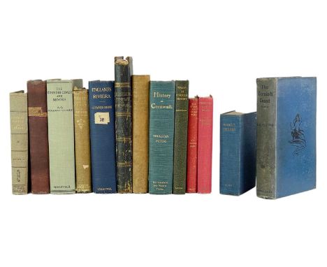
Thirteen works on Cornwall. Thurstan C. Peter and J. J. Daniel. 'A Compendium of the History and Geography of Cornwall,' fourth edition, vg original blue cloth, later uniform library dj, fold out map as frontis, spotting to title page and edge of text block, pp.485, good to vg, Netherton & Worth, Truro, 1906; J. Harris Stone. 'England's Riviera,' second edition, vg original blue cloth, ex libris with label to spine, later dj, fronts and plates, vg, Kegan Paul, Trench, Trubner & Co, London, n.d; George Laurence Gomme (ed). 'the Gentleman's Magazine Library,' part II only containing Cornwall, original cloth, text block loosening, some slight toning and spotting, Elliot Stock, London, 1892; 'The Beauties of England and Wales,' vol II only containing Cornwall, rubbed and bumped half leather, later dj, some toning and spotting, Vernor and Hood et al, London, 1801; Alphonse Esquiros. 'Cornwall and its Coasts,' original green cloth with chips to head of backstrip, ex libris Mary Molesworth Cordelia Cator, vg text block, Chapman and Hall, London, 1865; Peter Penn (ed). . 'Cornish Notes & Queries,' first series, original cloth, vg, Elliot Stock, London, 1906; With seven other works including a rough 'Itinery of Cornwall' by Cyrus Redding. (13)John Stengelhofen (1939-2020). Please see lot 1 for provenance.
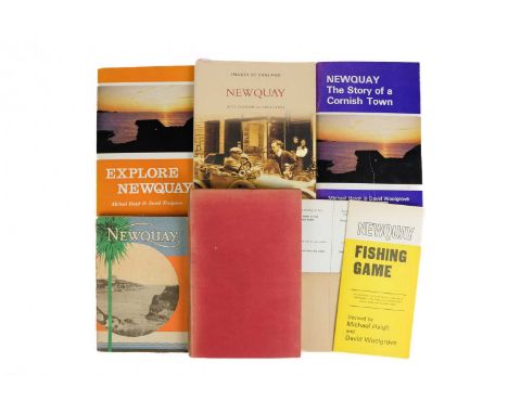
Newquay interest. 'Newquay. On the Cornish Coast,' a charming early 20th century tour guide with bright original card wraps and fold out map to rear, profuse with advertisements and vignette photographs, light spotting to wraps otherwise vg, pp.130, The Western National Omnibus Co, Newquay, [c.1920]; S. Teague Husband. 'Old Newquay,' illustrations by A. A. Golding, original cloth, some toning but generally g to vg, plates, pp.124, F. E. Williams & Co, Newquay, 1923; With three other works and 'Newquay Fishing Game' with counters and sleeve, in a fine condition. (6)John Stengelhofen (1939-2020). Please see lot 1 for provenance.
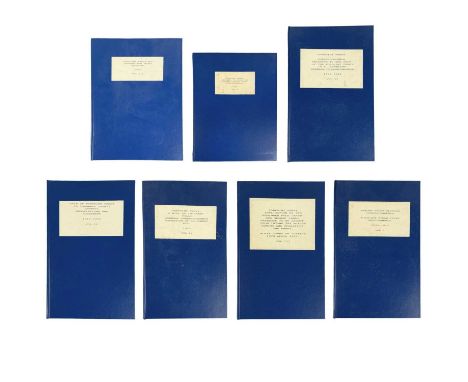
Torpoint Ferry Interest. Carew-Pole Papers Correspondence, plans, surveys etc for a new ferry, 1893-1923. Vol I- 'Antony Ferry Closure Correspondence-Torpoint Steam Ferry Improvements, 1893-1919,' correspondence (both typed and MS) between solicitors and parties involved in the creation of a more efficient steamer "...similar to those used at Gosport, New York &c &c", thus "necessary to again excavate the ferry canal and form a Dock and Landing Stage...", fascinating documentation on the mechanisms involved, incorporating Lieut Gen Sir Reginald Pole-Carew, representatives of the Home Office, numerous solicitors and tenants of rented lands from the estate of Anthony House, including receipts, surveys, MS and typed letters etc, in uniform blue boards.Vol II-'Sale of Torpoint Ferry to Cornwall County Council- Negotiations and Agreement, 1919-1920,' correspondence (typed) from 'Walker, Martineau & Co (solicitors)', a 'Memorandum of Agreement between Sir Reginald Pole-Carew and Lord St. Levan,' and Cornwall County Office "That we approve the principle of the purchase of the Torpoint Ferry provided that details are approved by the Finance Committee", bound in uniform blue boards.Vol III-'Torpoint Ferry Application by Sir Reginald Pole Carew and Geroge James Craddock to be Exempt from Income Tax Whilst Owning and Operating the Ferry. Royal Court of Justice, 10th April 1919,' transcript of the Shorthand Notes of Bennett & Co, 67 & 69 Chancery Lane, London, W. C, Sir John Simon, K.C and Mr A. M. Latter appeared as Counsel for the Appellants, The Solicitor General and Mr Parr appeared as Counsel for the Crown, In the High Court of Justice, King's Bench Division, bound in uniform blue boards.Vol VI- 'A Bill to Increase Tolls. General Correspondence, Valuation of Equipment etc, 1920,' consisting of receipts, surveys of lands, buildings, stores and permanent fixings (including value), bills, 'Statement showing the amount of capital put in the Ferry undertaking..., 25th March 1920,' and a copy of correspondence regarding '...the removal of Antony Passage Ferry', bound in uniform blue boards.Vol V- 'Attempts to Close the Ancient Antony Ferry, Correspondence, 1921,' concerning '...if we should grant to Lieut Gen Sir Reginald Pole-Carew licence to discontinue, relinquish and cease to maintain the ancient ferry known as Antony Passage Ferry...,' draft letters, newspaper clippings of plans, opinion of Norman C. Armitage Lincolns Inn 27th July 1921, 'Instructions to Counsel to settle draft Writ of Ad Quod Damnum, correspondence from County Hall Finance Department etc, uniformly bound in.Vol VI- 'Correspondance Relating to the Sale of The Torpoint Ferry, 'S. S. Beatrice', 1922-1923,' letters from 'Walker, Martineau & Co, Antony House Estate Office, County Hall etc, uniformly bound in.Vol VII- 'Torpoint Ferry Map Showing New Ferry Crossing, 1919,' coloured for the proposed route, backed onto linen, uniform case, 71mm x 102mm. (7)


A large collection of OS maps. Some with colour pencil additions from Hooper, in varying condition but mostly vg, all rolled.Including;OS 25’ 1952 SX 2675 Hawks’s Wood, Bodmin Moor; OS 25’ 1953 SX 6780 Warren House Inn, Dartmoor; OS 25’ 1953 SX 6781 Kings Oven, Waker Hill, Dartmoor; OS 25’ 1907 Tremore, Wheal Prosper, (St Austell/Lanivet); OS 25’ 1907 Withielgoose Mills, Mulberry Downs, Lanivet; OS 25’ 1879 Gwinear Wall; OS 25’ 1908 Levant, Trewellard, Pendeen; OS 25’ 1908 Botallack, Carnyorth; OS 25’ 1908 Halamannning, Trescowe, Great Work, West Godolphin; OS 25’ 1908 Chun Down’s, Chun Castle; OS 25’ 1908 Carleen, Wheal Vor; OS 25’ 1908 Breage; OS 25’ 1907 Tremore, Tremorebridge, (St Austell/Lanivet); OS 25’ 1907 Withiel Mills, Mulberry Downs; OS 25’ 1908 Halamanning, Colenso; OS 25’ 1908 Pendeen Lighthouse, Pendeen Cliffs; OS 25’ 1908 Botallack Crowns Mine; OS 25’ (1908)? Balwest, Great Work Mine; OS 25’ 1907 Chapel Porth, Wheal Cotes, Wheal Charlotte; OS 25’ 1908 Map (photocopy) Roscroggan stream works; OS 25’ 1908 Map (photocopy) Roscroggan stream works; OS 25’ 1908 Map Roscroggan stream works; OS 25’ 1908 Map (photocopy) Roscroggan stream works. From the estate of Ron Hooper, M.V.O., A.C.S.M., F.I.M.M.Born in St.Agnes, he graduated from Camborne School of Mines. After a short career mining in the Gold Coast of Ghana he joined the Camborne School of Mines, eventually becoming Senior Lecturer in Surveying. At the same time, he acted as an independent mining engineer and was appointed mineral agent for several Cornish estates including the Duchy of Cornwall, Tregothnan, and the Godolphin Estate (amongst others).
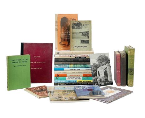
Diverse collection of twenty four works. 'Gulval Church and Churchyard. Past and Present,' thin leather wraps with gilt lettering, b+w photos pated to thin card, vg, scarce, Beare and Son, Penzance 1894; Joseph Hammond. 'A Cornish Parish: Being an Account of St. Austell, Town, Church, District and Peple,' first edition, original green cloth with gilt lettering and decorations to back strip, later uniform library dj, plates, maps, and frontis, toning to title page, light spotting but vg, Skeffington & Son, London, 1897; R. S. Hawker. 'Footprints of Former Min in Far Cornwall,' original embossed cloth, light mold staining to bottom of front board, later uniform library dj, plates and frontis, goog to vg, John Lane, London, 1903; A. Newland Deakin. 'Guide to Fowey & Neighbourhood,' printed card wraps, advertisements, plates, fold out map, William Pollard & Co, Exeter, 1892; Dorothy Dudley. 'The Slate Figures of Cornwall,' first edition, original cloth, unclipped dj, Worden Printers, Marazion, [1965]; Cyril Noall. 'A History of Cornish Mail- and Stage-Coaches,' first edition, original cloth, unclipped dj, some spotting to DJ and edge of text block, D. Bradford Barton, Truro, 1963; With nineteen other good works. (24)John Stengelhofen (1939-2020). Please see lot 1 for provenance.


St Agnes area including Cligga mine. Thirty five geological plans by Concord Tin Mines Limited, average size 74cm x 105cm; with many other charts and surveys with amendments including a facsimile print titled 'Compilation Map. Cornwall Tin & Mining Corp. St. Agnes- Cligga Properties. Manor of Tywarnhaile', 'Mine and Grid Topography', 'Pan II. Wheal Concord Mine Geology', &c. &c. (35+) From the estate of Ron Hooper, M.V.O., A.C.S.M., F.I.M.M.Born in St.Agnes, he graduated from Camborne School of Mines. After a short career mining in the Gold Coast of Ghana he joined the Camborne School of Mines, eventually becoming Senior Lecturer in Surveying. At the same time, he acted as an independent mining engineer and was appointed mineral agent for several Cornish estates including the Duchy of Cornwall, Tregothnan, and the Godolphin Estate (amongst others).

Mine plans and surveys. Notes 1908-1946 on shafts, lodes, underground workings, history & statistics about the above mines, plus underground sections New Polbreen & West Polbreen; Printed aerial photographs of quarry; OS 25’ Photocopy, map of Perranporth Airfield, with shafts and underground workings superimposed; 1:25,000 Plan of Cligga Mine; OS 25’ Photcopy, South Wheal Towan, Tin Mine Ltd; OS 25’ Photocopy, Cligga Mine, Great St George Mine, underground workings superimposed by RCAH; OS 6’ 1908, superimposed with boundaries, Wheal Rose, North Treskerby, Wheal Briton, RCAH; OS 6’ 1908, Superimposed by RCAH with boundaries of South Towan, East Wheal Fancy, East Wheal Music, South Wheal Butson, East Tywarnhayle, Wheal Tallack, North Towan, Wheal Freedom & West Polbream Mines; OS 6’ 1908, Superimposed by RCAH with boundaries; OS 6’ 1908, Superimposed by RCAH with boundaries of Wheal Anna, North Engelly, Wheal Albert, West Wheal Hope, Ty Tyas (?), Treworthan; OS 6’ 1908, Superimposed with boundaries of Blue Hills, East Blue Hills, Princess Royal, Wheal Prudence, Treslaw Sett; Sections 1:200 East of Bissoe Bridge, drawn by RCAH; Surrey notes and plan 1:1000 drawn by RCAH of Wheal Bussy; OS 6’ Photocopy, Great Wheal Busy, location of sections surveyed in 459; ‘Hearle Family Partition – Map No 2’ Showing lands divided between F.F.Rodd Esq, J.C.L.Tremayne Esq, C.S.Richardson; Tracing of all the mining sett boundaries in Tuckingmill and Redruth Cardrew; Tracing showing all the adits (including the county adit) in Redruth, Wheal Tolgus to St Day, Carharrack, Wheal Jane; 1819 Photocopy, Map of the mining district of Cornwall, between Camborne and Chasewater, showing The Great Adit; Original tracing, Redruth and marked mines area, (Plan of Great County Adit); Prints from 465/466 original tracing, mines marked and named; Hand drawn plan of St Day and Carharrack with superimposed shafts, adits and lodes. From the estate of Ron Hooper, M.V.O., A.C.S.M., F.I.M.M.Born in St.Agnes, he graduated from Camborne School of Mines. After a short career mining in the Gold Coast of Ghana he joined the Camborne School of Mines, eventually becoming Senior Lecturer in Surveying. At the same time, he acted as an independent mining engineer and was appointed mineral agent for several Cornish estates including the Duchy of Cornwall, Tregothnan, and the Godolphin Estate (amongst others).
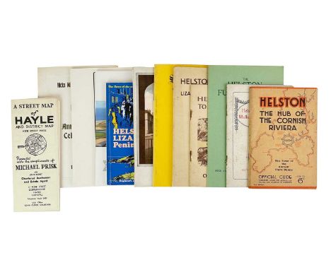
(Helston, Hayle, Helford &c., &c) Booklets and ephemera Edward M. Cunnack. 'The Helston Furry Dance,' thin card wraps, staple bound, plates and illustrations, pp.19, vg, P. S. Brewer, Helston, [1972]; 'From Helford River to Mounts Bay.... Official Guide,' printed card wraps, rust to staple bind, advertisements and illustrations throughout, some light spotting but generally vg, n.d; 'Helston and the Lizard Area....Official Guide,' printed card wraps, rust to staple bind, plates, vg, the Helston and District Chamber of Commerce, Oscar Blackford, Truro, n.d; Edna Waters Coward. 'St. Hilary. Once the Mother Church of Marazion, in Mounts Bay, Cornwall,' thin card wraps, staple bound, plates, pp15, fine, The Pharmacy, Dorset, n.d; With eight others including A Street Map of Hayle and Dristrict. (12)John Stengelhofen (1939-2020). Please see lot 1 for provenance.


Christopher Saxton and John Speed, Norfolk - A Countie Florishing & Populous Described and Devided with the Armes of such noble families as have borne the titles therof, published by John Sudbury and George Humble, circa 1627, hand-coloured engraved map, inset town plan of Norwich and battle scene, 38 by 50cm, framed


GROUP OF UNFRAMED MAPS including Ordnance Survey (Scotland and England) and anglers river mapsSalmon pools on the river Tay x2 100cm x 35cm overall good condition Salmon pools on the river cassley 62cm x 24cm overall good condition 1909 map of Yorkshire (west riding) sheet CLIII.5 104cm x 74cm. Decent condition small tears around the edges.1909 map of Yorkshire (west riding) sheet CLIII.2 104cm x 74cm decent condition small folds and tears around the edges1909 map of Yorkshire (west riding) sheet CLIII.3 104cm x 74cm similar condition to previous 1909 map of Yorkshire (west riding) sheet CLIII.1 104cm x 74cm similar condition to previousordinance survey of Yorkshire sheet SE15NE 56cm x 73cm overall good condition ordinance survey of Yorkshire sheet SE15NW 56cm x 73cm overall good condition

Vocke, Alfred (Polish, 1886-1944); b. Breslau, moved to Germany 1917, returned to Poland 1937 GERMANY, Rein-Nickel, 1936, a nickel medal by A. Vocke for the Vereinigte Deutsche Metallwerke AG, kneeling male miner, hands clasped on an axe, surrounded by seven bearded dwarves, rev. map of the Eastern hemisphere, edge impressed preuss. staatsmünze 1936 ni. 99,5% [Berlin mint], 56mm, 74.74g (cf. Teutoburger 134, 2002; cf. WAG 67, 3607). Extremely fine £40-£50 --- Provenance: bt A.C. Eimer, August 2013 Vereinigte Deutsche Metallwerke AG (VDM), created in 1930, removed to Frankfurt in 1934 and by the outbreak of World War II employed 21,000 people. The medal names Basse & Selve, the Altena-based manufacturer of engines for cars, motorcycles, boats and aeroplanes which, though founded in 1908, had closed in 1932, four years before this medal was issued; VDM took over their site in Altena and ran it as one of their eight factories.

Brunet, Georges-André (Belgian, 1902-1986); b. Brussels, and Fonson, Jean, later Jules (Brussels, 1848-present) BELGIAN CONGO, Cinquantième Anniversaire de l’Union Minière du Haut-Katanga, 1956, a bronze medal by G.-A. Brunet for Fonson, crucible from which metal flows above a map of the Belgian Congo, rev. male engineer demonstrating a cogwheel and a surveying instrument to three male youths, open book on table in foreground, edge impressed fonson, 85mm, 238.10g (Lippens/van Keymeulen 148; BM Acq. 1983-7, pl. 19, 1; cf. DNW 60, 1566). Extremely fine; in original maroon card case [base of case in need of minor repair] £30-£40
![Beutler, Miloslav (Bohemian, 1897-1964); b. Pardubice CZECHOSLOVAKIA, Mnichovská Dohoda [Munich Agreement], 1938, a bronze](https://cdn.globalauctionplatform.com/ea685ac1-52dc-4e60-9798-b0c900f3ff71/fe1a9672-b770-409f-ad3a-b0c900f6c894/468x382.jpg)
Beutler, Miloslav (Bohemian, 1897-1964); b. Pardubice CZECHOSLOVAKIA, Mnichovská Dohoda [Munich Agreement], 1938, a bronze medal by M. Beutler, robed female artisan standing half-right, vignettes of commerce in background, rev. hands surrounding a map of Czechoslovakia from which a hand emerges with fingers and thumb blunted, 55mm, 59.98g (cf. Aurea e41, 2295). Some light discolouration, otherwise good very fine £25-£35 --- Provenance: bt Simmons, December 2014 The Munich Agreement of 30 September 1938 was a settlement reached by Germany, Great Britain, France and Italy which permitted German annexation of the Sudetenland in western Czechoslovakia.

Bottée, Louis-Alexandre (French, 1852-1941); b. Paris U.S.A., Exposition Universelle Internationale, San Francisco [Panama-Pacific International Exposition], 1915, a bronze plaque by L.-A. Bottée for the Comité Français des Expositions à l’Etranger, robed female standing amongst ruins symbolic of the San Francisco earthquake of 1906, the city itself beyond, rev. map of the Americas, the location of the canal symbolized by a radiant torch, above a view of the French exhibition building, edge stamped bronze and cornucopia, 78 x 57mm, 132.55g (Maier 140; cf. DNW 86, 192). Very fine £90-£120 --- The exposition was held in San Francisco from 20 February to 4 December 1915. The French exhibition building was a copy of the Palais de la Légion d’honneur in Paris.

Kutterink, Marinus (Dutch, 1907-1983); b. Losser, and Koninklijk Begeer (Utrecht, 1878-present) NETHERLANDS, 50 Jaar N.V. Electriciteits-Maatschappij IJsselcentrale, Zwolle, 1961, a bronze medal by M. Kutterink, standing male figure holding bowl of fire, flanked by flashes of lightning, rev. electricity grid on map, power plant below, 70mm, 138.22g (Begeer 2674; cf. MPO 44, 5316). Extremely fine £15-£25 --- Provenance: bt Simmons, November 2002

Simmons, Mary Ann (British, 1959-present); b. Vancouver, emigrated to United Kingdom 1988 ENGLAND, The Fourth Service 1939-1945, 2002, a cast bronze medal by Mary Ann Simmons [Crucible Foundry] for the British Art Medal Society, concentric radiating waves, rev. map of the Western Atlantic approaches and the Rockall Trough, site of the first vessel to be sunk by a U-boat on the first day of World War II, edge highlight-impressed the fourth service 1939-1945 between the points of the compass, highlight notches on upper reverse edge, 90mm, 545.65g (The Medal 41, pp.118-19). Extremely fine, as made, a poignant medal, very rare; in black pouch of issue £100-£150 --- Provenance: bt BAMS, April 2003 Edition of 10. The medal commemorates the role of the Merchant Navy as the ‘fourth service’ during World War II. The reverse alludes to the sinking of the passenger liner Athenia, outbound from Liverpool to Montreal, torpedoed by U-30 220 miles north-west of Ireland at 7.30pm on 3 September 1939, the day that Britain declared war with Germany, with the loss of 117 lives. For a full description of the background to the issue of the medal and for an explanation of the notches on the upper part of the reverse, see The Medal 41, p.118.
![Förster, Richard (Russian, 1873-1956); b. St Petersburg, moved to Germany after 1900 GERMANY, Weltkrieg [World War], 1919,](https://cdn.globalauctionplatform.com/ea685ac1-52dc-4e60-9798-b0c900f3ff71/072d8711-1ee9-46e2-ba2b-b0c900f63514/468x382.jpg)
Förster, Richard (Russian, 1873-1956); b. St Petersburg, moved to Germany after 1900 GERMANY, Weltkrieg [World War], 1919, a bronze medal by R. Förster, robed figure bestriding landscape, holding torch and serpent, rev. map of the globe with flames issuing from Germany, banner below, 67mm, 105.92g. Extremely fine and very rare £80-£100 --- Provenance: bt Simmons, September 2003

Turin, Pierre (French, 1891-1968); b. Sucy-en-Brie, Paris MONACO, Principauté de Monaco, 1943, a bronze medal by P. Turin, view of the principality, rev. aerial map, Grimaldi arms above and rays of the sun behind, edge impressed bronze and cornucopia, 68mm, 150.49g (CGMP p.379; cf. Baldwin 39, 1904; cf. DNW M8, 2363). Good very fine £30-£40 --- Provenance: bt Irene Allen, October 2005


TRAVEL: BUCKINGHAM (James): 'Canada, Nova Scotia, New Brunswick, and the other British Provinces in North America...': London, Fisher, Son & Co, n.d (c.1850): folding map frontispiece, 540pp, contemporary half calf gilt, recased, light wear, 8vo: HOOKER (Joseph Dalton) 'Himalayan Journals': London, Ward, Lock & Co, 1905: publishers red cloth gilt, a bit rubbed and sunned, 8vo: with a box of misc. other travel books, 19th century and later. (Box)

LONDON: 'A Complete Guide to all Persons who have any Trade or Concern with the City of London and Parts Adjacent...': London, printed for J Rivington et al, 1763: 9th edition. With frontispiece plan of the Royal Exchange and folding map of the city, contemporary blind tooled speckled calf, four raised bands to spine, 206pp plus table at rear, 12mo. (1)
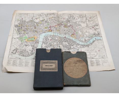
MAPS: Darton & Harvey (publisher): 'London Westminster and Southwark shewing the various alterations...': 1804, copper engraved map with hand colouring, 46 x 58cm, vertical centre fold, light toning and creasing, a few short tears and chips to margins: together with 'Cary's Reduction of his Large Map of England and Wales, with part of Scotland, containing the whole of the Turnpike Road, the principal rivers & the course of the different navigable canals..', printed by J Cary, 1805: folding map laid on linen, slipcase with printed label, a little rubbed and marked: with another 19thc folding map. (3)


LONDON MAP: 'The Pedestrian's Companion: 15 miles Round London': London, published by E Grattan, 1836: folding map with contemporary hand colouring, printed on paper and laid onto linen, dissected onto 21 sections, original blue cloth covers with gilt cartouche to upper, 48pp guide bound at rear cover, some toning and wear. (1)


-
109198 item(s)/page