We found 109198 price guide item(s) matching your search
There are 109198 lots that match your search criteria. Subscribe now to get instant access to the full price guide service.
Click here to subscribe- List
- Grid
-
109198 item(s)/page


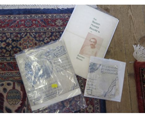
Lot 354
Arthur S. Sullivan: Two silk handkerchiefs printed with The Absent Minded Beggar with the words by Rudyard Kipling, a map of Southern Africa and a portrait of Lord Roberts another in cotton, and two brochures of The Absent Minded Beggar published by the Daily Mail Part of the late Peter Joslin collection of Gilbert & Sullivan and Theatre memorabilia

Lot 379
Books: A Philips Map of London for Visitors, 1877, hardbacked (as found); The Panorana of London by T. Allen, 1830 (rebound); Musical Haunts in London by F.G Edwards; The City Temple, Past Present and Future and a reprint of the Grand Panorama of London (5) Part of the late Peter Joslin collection of Gilbert & Sullivan and Theatre memorabilia
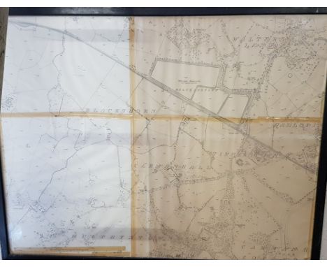


Lot 963
The English Channel, three cloth backed charts published by Charles Wilson (late J.W. Norrie and Wilson) 156 minories, 1884, each chart 106 cm x 73 cm overall and the River Thames from the late surveys drawn by J.S. Hobbs FRGS hydrographer, published by C Wilson (late J.W. Norrie and Wilson, 1883) cloth backed, 67 cm x 100 cm and a hand coloured map of the colony of New South Wales exhibiting the situation in and extent of the appropriated lands.... dedicated to Sir John Barot by his obliged humble servant Robert Dixon, 127.5 cm x 81 cm and a small fragment of a hand coloured map of Western Australia (6) (see illustration).


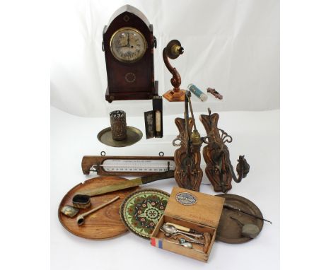
Lot 253
An early 20th century mahogany inlaid dome-top eight-day mantel clock, gilded dial set with Roman numerals (af) and a quantity of metalware to include a pair of Art Nouveau wall-mounted electroliers, an F Pastorelli of London small wall barometer and a wooden page turner with calendar dated 1898 with decorative map of the Russian Empire.


Lot 373
TWELVE ANTIQUE MAPS FEATURING STAFFORDSHIRE, some of the maps have been hand coloured within the last thirty years, Samuel J.Neele - Staffordshire c1812, J.Alkin - a plan of the Trent and Mersey canal c1795, R.Crighton - Staffordshire c1835, Sidney Hall - Staffordshire c1832, Charles Smith - Staffordshire c1822, J.Cary - Staffordshire c1787, J.Ellis - a modern map of Staffordshire c1766, J.Alkin - Staffordshire c1794, S.Simpson/R.Walker - Staffordshire c1746, George Cooke - Staffordshire c1809, T.Jenner - Staffordshire route distances c1657 and a Dutch map of Staffordshire by Pieter Meijer c1766

Lot 412
TWELEVE ANTIQUE MAPS FEATURING STAFFORDSHIRE, some of the maps have been handcoloured within the last thirty years, to include Thomas Kitchen-Bowles reduced map of Staffordshire c1769, Joshua Archer, Staffordshire c.1842, Thomas Kitchen, a new map of Staffordshire c.1764, Hans Cooper, Staffordshire c.1808, Thomas Kitchen, Staffordshire c.1769, W S Orr, Staffordshire c.1852, Sidney Hall, Staffordshire, a white on black woodblock print c.1833, T Badeslade and W H Toms, a map of Staffordshire c.1741, Sidney Hall, Staffordshire c.1820, R Butters, Staffordshire c.1803, John Cary Staffordshire c.1789, Mary Rodwell, Staffordshire c.1834


Lot 296
John Throsby, The History and Antiquities of the Ancient Town of Leicester, Leicester 1791, together with the supplementary volume To the Leicestershire Views, containing a series of excursions in the year 1790 to the villages and places of note in the county, London 1790, the folding county map uniform red half-calf (the boards of the supplementary volume mis-shapen), 4to, (2).


Lot 69
A British Army issued knapsack, 20th Century.With leather straps, A WWII British gas mask bag dated 1942, WWII period map/document bag for Sgt Major W. Shelmerdine of the Royal Horse Artillery, a War Department issued wood plane dated 1941, Air Ministry issue ammunition pouches, canvas belts etc.

Lot 75
Bacon's New Shilling map of the seat of war in Virginia and Maryland, 1862Fold out map produced by Bacon & Company, 48 Paternoster Row, London, 1862, 62x49cm, framed and glazed, The Guide to Paths in the Blue Ridge, The Appalachian Trail and Side Trails in Southern Pennsylvania, Maryland and Virginia, published by The Potomac Trail Club, Washington 1941, with many fold out maps, bound in black cloth with gilt lettering (2)


Lot 67
English School, 19th Century, oil on canvas, Portrait of a Young Woman', 40.7 x 30.6 cm, framed and glazed, together with, 19th Century Dutch School, oil on canvas, 'Still Life with Flowers', 50.3 x 40.5 cm, framed; R. Jameson, oil on board, 'Landscape with Ducks and Cows', signed 'R. Jameson' (lower right) 30.5 x 40.8 cm, framed; Joan Blaeu, 'Svthsexia Vernacule Svssex', later hand coloured map of Sussex, 45 x 58.6 cm, unframed; 20th Century lithograph of geese migrating, 45.6 x 62.6, framed and glazed; an oleograph after a 17th Century Dutch floral still life, 23. 2 x 28 cm, framed (6)


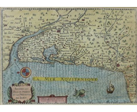
Lot 561
A 17th century French map titled 'Bourdelois Pais de Medoc et La Prevoste de Born', showing the coastline around Bordeaux, hand coloured with motifs in La Mer Aquitanique, with distance scale titled 'Miliaria Germanica Comunica', 17 by 24cm, framed, 29 by 36cm, together with a William Kip 17th century map of Rutlandia, hand coloured, 30 by 23cm, framed, 42 by 33cm. (2)


-
109198 item(s)/page