We found 109198 price guide item(s) matching your search
There are 109198 lots that match your search criteria. Subscribe now to get instant access to the full price guide service.
Click here to subscribe- List
- Grid
-
109198 item(s)/page


Lot 843
FARRINGTON (JOSEPH) THE LAKES OF LANCASHIRE, WESTMORLAND AND CUMBERLAND DELINEATED IN FORTY-THREE ENGRAVINGS..... WITH DESCRIPTIONS, TOPOGRAPHICAL AND PICTURESQUE THE RESULT OF A TOUR MADE IN THE SUMMER OF 1816 BY THOMAS HARTWELL HORNE plts generally spotted, double page map, hand coloured, half calf, spine gilt, aeg, 1816

Lot 844
A FULLERTON & CO, PUBLISHER SCOTLAND ILLUSTRATED IN A SERIES OF EIGHTY VIEWS FROM DRAWINGS BY JOHN C BROWN, WILLIAM BROWN [ET AL] plates and vignette title, D'Ewes Coke's copy with his signature and date 1846 on the ffe, half green morocco gilt, 1845 § William Beattie Scotland Illustrated in a Series of Views taken expressly... by Messrs Allom, Bartlett, etc, two vols plates and folding map, D'Ewes Coke's copy with his signature and date 1836 on the ffe, 1838 (3)

Lot 846
PINNOCK & MAUNDER, PUBLISHERS THE HISTORY AND TOPOGRAPHY OF NOTTINGHAMSHIRE WITH BIOGRAPHICAL SKETCHES..... AND A NEAT MAP OF THE COUNTY folding map, woodcut vignette of Nottingham Castle to title, wrappers, c1820, Executions at Nottingham during the last Century with a Short Biographical Sketch of each Culprit......, two copies, Nottingham 1827 § A Stapleton, A History of the Public Crosses of Old Nottingham, folding plan, 100 copies printed, book label of E S Cowen, wrappers, Nottingham Frank Murray 1893, rare and seven others, Nottingham handbooks and guides, etc (11)


Lot 856
BINNS (JONATHAN) THE MISERIES AND BEAUTIES OF IRELAND two volumes, map, green cloth gilt with Irish harp, 1837 § William Carleton - Traits and Stories of the Irish Peasantry, two volumes, new edition, lithographed title and frontispiece, wood engraved illustrations, embossed cloth, 1843 and 1845, all signed by W A Cadbury, worn, corners rounded, one frayed (4) ++++

Lot 858
HAYWARD (RICHARD) IN THE KINGDOM OF KERRY illustrations after T J Gracey, cloth backed boards, Dundalk: Dundalgan Press, 1946 § Margaret Stokes - Early Christian Architecture in Ireland, 1878 § twenty others, Irish life and literature including Fraser's Travelling Map of Ireland coloured in outline, green cloth, 1859 (23) ++++
Lot 862
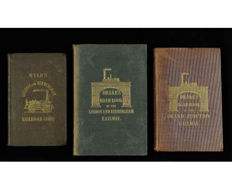
DRAKE'S ROAD BOOK OF THE LONDON AND BIRMINGHAM RAILWAY folding map, coloured in outline, illustrations and vignettes in the text, embossed green cloth gilt, aeg, 1839 § - Drake's Road Book of the Grand Junction Railway…. to which is appended the Visiter's Guide to Birmingham Liverpool and Manchester, second edition, Birmingham 1838, both signed by W A Cadbury § J.W.W. [James Wyld] - The London and Birmingham Railway Guide and the Birmingham and London Railway Companion, second edition, 1838 (3) ++++


Lot 77
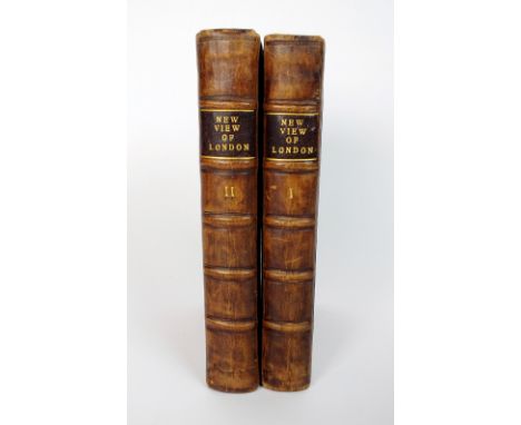
HATTON, Edward, A New View of London, or an Ample Account of that City', 2 vols, Printed for R. Chiswell, 1708, contemporary panelled calf, rebacked, lacks one plate of arms, but includes folding plan of London in Queen Elizabeth's time, and folding map of the City of London, Westminster, and the Borough of Southwark (2)

Lot 846
WWII GERMAN MAP OF AIR STRIKE FORCES AND DEFENCES OVER WESTERN EUROPE printed by Veriagsanstalt List & von Bressendorf, Leipzig 1943, titled 'Der Nordfeeraum und Wefteuropa mit Westwall und Maginot-Linie', also showing lines of defence of the German Army, framed and under glass, 111cm high x 87cm wide

Lot 1
A fine George III 3 inch pocket globe John and William Cary, London, circa 1791 The sphere with metal pivot pins to the poles and applied with twelve hand coloured printed gores with the equinoctial graduated in degrees and hours and the ecliptic graduated in days, the prime meridian labelled Meridian of Greenwich and the principal land masses outlined in colour and annotated with major rivers and mountain ranges, the oceans with islands labelled and printed with dotted lines for Resolution, Captain Cook 1773 and other circumnavigations complete with dates a vessels named, the South Pacific region incorporating circular printed title cartouche CARY'S, Pocket, GLOBE, agreeable, to the latest, DISCOVERIES, LONDON, Pub'd by J. & W. Cary. Strand. Apr. 1. 1791, the spherical fishskin covered case lined with printed map inscribed The WORLD as known in CESAR'S Time, agreeable to D'Anville opposing A TABLE, of, Latitudes & Longitudes, of Places not given, on this GLOBE , overall diameter 9cm (3.5ins) approx. William Cary is recorded in Clifton, Gloria Directory of British Scientific Instrument Makers 1550-1851 as born circa 1759 and apprenticed to Jesse Ramsden. William worked from 272 Strand, London 1789-90 then 182 Strand 1794-1822, he died in 1825. John Cary (I) is recorded by Clifton as a map, globe and chart engraver who was born in 1755 and worked from Johnson's Court, Fleet Street 1782 then Corner of Arundel Street, Strand 1783 before moving to 188 Strand 1783-1790 followed by 181 Strand 1792-1805. He is last recorded working at 86 St. James Street 1820-21. Although the brothers William and John Cary appeared to work independently they also collaborated on certain projects including the publication and manufacture of the current lot.


Lot 8
Christopher Saxton (c.1540-c.1610) A MAP OF NORTHUMBERLAND engraving with hand-colouring 38 x 50cms; 15 x 19 1/2in. (plate size); B*** R*** Davies (19th Century) MAPS OF LONDON FOR THE POST OFFICE DIRECTORY published 1875 and 1880 engravings 67 x 90cms; 26 1/2 x 35 1/2in (plate size); together with various Middlesex maps, all unframed. (8)


Lot 329
John Cary, "Cary's New Map of England and Wales with Part of Scotland and Which are Carefully Laid Down All the Direct and Principal Crossroads, the Course of the Rivers and Navigable Canals...", London 1794, hand coloured maps in a leather cover, badly damaged to the lower corner and to the leather fold.


Lot 698
An oil painting on board, study of dead birds, signed with initials bottom right JW, 26 x 20 cm approx, a pair of 19th century coloured engravings of a pied wagtail and a red throated pipit, an oil painting on canvas of a Dutch harbour scene with fishing boats, signed bottom right A Giebenya (?), an early 19th century coloured engraving - Map of the Black Water River, 45 x 58 cm approx and a watercolour of a thatched cottage with colourful garden, signed bottom right Tom W Armes and dated 34, 37 x 55 cm approx, all framed


Lot 738
An assortment of pictures and prints including an oil on canvas depicting a country house, signed and dated Rainbow 1914, a framed and coloured antique map of Hereford by T Kitchen, a small Georgian coloured print depicting frolicking cherubs - Les Amoures, a humorous cartoon study in ink - Acanthus, a framed print of Chertsey Bridge, etc

Lot 771
Books relating to Sicily including Travels in the Two Scillies by Henry Swimburne in the years 1778 to 1780, second edition, 4 volumes approx, printed by J Nicholls 1790, leather bound with map and illustrations, Tour In Italy and Sicily by L Simond 1828, In Sicily by Douglas Sladen, 2 volumes approx 1901, (10 volumes approx)


Lot 343
ORMEROD (G), THE HISTORY OF THE COUNTY PALATINE AND CITY OF CHESTER, second edition revised and enlarged by Thomas Helsby, Vol I with etched frontis portrait plate of Thomas Helsby, hand coloured double page map of Chester and other steel engraved plates and decorations, 3/4 leather with cloth boards, London, George Routledge, 1882 (3)


Lot 455
OLIVER Thomas, Topographical Conductor or Descriptive Guide to Newcastle and Gateshead, Newcastle 1851, original cloth, folding plan; HUBBERTHORN Richard, Travels and Adventures in Holland, Westphalia and other parts of Germany, Newcastle 1830, recently rebound cloth; COOKSLEY W.G. Explanatory Index to the Map of Ancient Rome, Eton 1851, cloth folding linen map in pocket, all vols 8vo (3)

Lot 494
BLOMEFIELD Francis, An essay Towards a Topographical History of Norfolk, Fersfield 1739-1775, first edition, 5 vols folio full calf, joints cracking vol.I, 31 plates including 5 folding and 2 maps, plus 2 extra folding plates in vol.V, vol II lacks the map of Norwich, but an extra vol.II is included with the set in uniform binding which is extra illustrated including the folding map of Norwich on linen and 17 additional plates (6)


Lot 508
PECK's Norwich Directory c1802 with folding map, worn paper on boards; BERRY's Norwich Directory for 1811, Norwich 1810, folding map on linen at front is Samuel King's map published 1766, front board detached; BLYTH'S Norwich Directory 1843; Norfolk and Norwich Remembrances 1801 rebound half calf retaining original wraps; Norwich & Norfolk Annual Memorandum-Book 1804 lacks cover (5)


-
109198 item(s)/page