
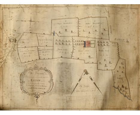
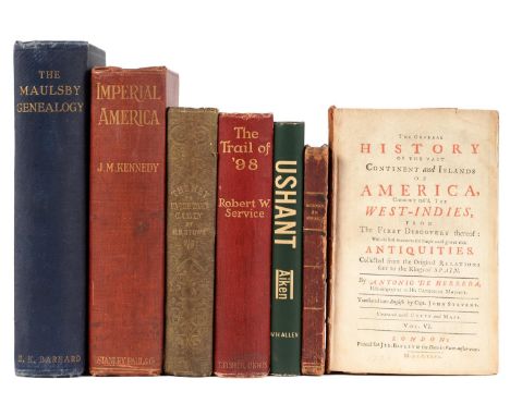
Lot 129
C Smith, 'A New Map of England and Wales, comprehending the whole of the Turnpike roads with the great rivers and navigable canals'. Originally printed 1804 second edition corrected to 1808 (58x47cm approx), together with Thomas Kitchen, a 'New Map of Shropshire'(25.5x20.5cm approx). And a strip road map of Ludlow and Shrewsbury in the Deanery of Chester pages 145 and 146 double sided (19x12cm approx). Together with Thomas Kitchen, 'Africa', original uncoloured map engraved by G Terry for John Harrison, dated 1787. 34x39cm approx. Framed. Together with a 19th century map of Sweden and Norway engraved by S Hall. 25x19cm approx. Framed and glazed. (5) (B.P. 21% + VAT)


![Greenwood (Christopher & John), Atlas of the Counties of England [and Wales], from Actual Surveys made from the Years 181](https://cdn.globalauctionplatform.com/662cb969-5584-4034-a004-b10000c209d5/f4d5825a-aea2-413c-bfc2-b1000108971d/468x382.jpg)


![Johnson (Samuel), A Dictionary of the English Language [...], eleventh edition, Edinburgh: Printed for Thos. Brown, R. R](https://cdn.globalauctionplatform.com/662cb969-5584-4034-a004-b10000c209d5/38a4014b-69af-4d45-9082-b100010758d4/468x382.jpg)
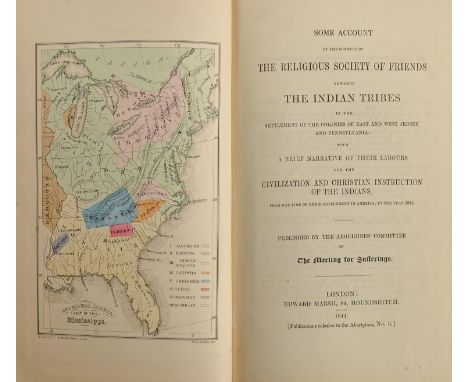
![India. The Bengal Directory and General Register for the Year 1832. [With] A General Index to Names [...], Calcutta: Com](https://cdn.globalauctionplatform.com/662cb969-5584-4034-a004-b10000c209d5/67637a67-1309-4e35-9b6d-b1000107516e/468x382.jpg)
![Liverpool. Enfield (William), An Essay Towards the History of Liverpool [...], first edition, Warrington: s.n., 1773, vi](https://cdn.globalauctionplatform.com/662cb969-5584-4034-a004-b10000c209d5/4c475fc0-8689-41d0-9185-b10001075d38/468x382.jpg)


![Bowles's New Four-Sheet Map of England and Wales [...], London: Printed for the Proprietors Bowles & Carver, n.d. [1](https://cdn.globalauctionplatform.com/662cb969-5584-4034-a004-b10000c209d5/26dc3199-1c6c-4333-8fde-b100010893c8/468x382.jpg)

![Local Interest. Thoroton (Robert, Doctor of Physick (sic)), The Antiquities of Nottinghamshire [...], Beautified with Ma](https://cdn.globalauctionplatform.com/662cb969-5584-4034-a004-b10000c209d5/1213769c-2aa1-4576-8f82-b100010761cd/468x382.jpg)
![India. [Sri Lanka] Map of Ceylon, London: Edward Stanford, October 2nd, 1882, steel engraving, contemporary hand-coloured del](https://cdn.globalauctionplatform.com/662cb969-5584-4034-a004-b10000c209d5/a76f4726-b5ea-43d8-bfcc-b10001074e19/468x382.jpg)
![Politics and History. [Miège (Guy)], The Present State of Great-Britain and Ireland, third edition, London: Printed for J.H.](https://cdn.globalauctionplatform.com/662cb969-5584-4034-a004-b10000c209d5/7ec5fce0-990c-4ae3-9a52-b1000107995d/468x382.jpg)

![Bindings, 'Miniature' Books. [Bible, New Testament] Novum Testamentum [...], Polymicrian edition, Londini: Sumptibus Samuelis](https://cdn.globalauctionplatform.com/662cb969-5584-4034-a004-b10000c209d5/09dbab0a-9606-45ce-b76e-b100010877a5/468x382.jpg)
![[Atlas] Moll (Herman, Geographer), A Set of Fifty New and Correct Maps of England and Wales, &c. With The Great Road](https://cdn.globalauctionplatform.com/662cb969-5584-4034-a004-b10000c209d5/13d705ce-1719-4b72-bf98-b1000108903b/468x382.jpg)


![Bibles, Theology & Thought. [KJV, 1611] The Holy Bible, containing the Old and New Testaments and the Apocrypha, fourteen](https://cdn.globalauctionplatform.com/662cb969-5584-4034-a004-b10000c209d5/e4f00945-033d-452c-a430-b1000107ff8e/468x382.jpg)


![Binding. [Latin Vulgate Bible] Biblia Sacra [...], Tornaci Nerviorum [Tournai]: typis Societatis Sancti Joannis Evangelistae,](https://cdn.globalauctionplatform.com/662cb969-5584-4034-a004-b10000c209d5/9500bcfd-0519-4280-8726-b10001084229/468x382.jpg)

![Local Interest. [Cox (Thomas)], Nottinghamshire, [from Magna Britannia et Hibernia], [In the Savoy: Eliz. Nutt, 1720], d](https://cdn.globalauctionplatform.com/662cb969-5584-4034-a004-b10000c209d5/27bfb376-ab85-4e36-9d1d-b10001075ec2/468x382.jpg)

![A 19th c lady's commonplace book, Agnes Robina McGeorge, n.d. [c. 1830], approx. [200]ff of manuscript extracts from bel](https://cdn.globalauctionplatform.com/662cb969-5584-4034-a004-b10000c209d5/1b479d58-8f37-4f8d-93ea-b1000107e296/468x382.jpg)
![Royal Navy. [Travel] Hall (Commander W.H., RN) & Bernard (W.D.), Narrative of the Voyages and Services of The Nemesis fro](https://cdn.globalauctionplatform.com/662cb969-5584-4034-a004-b10000c209d5/cfaae11b-a174-4642-aa5d-b1000107a7e7/468x382.jpg)