We found 109198 price guide item(s) matching your search
There are 109198 lots that match your search criteria. Subscribe now to get instant access to the full price guide service.
Click here to subscribe- List
- Grid
-
109198 item(s)/page
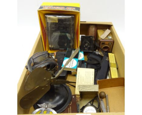


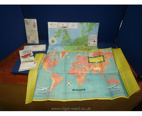
Lot 1465
A collectable old Air France folder and leaflets within including a large Routes flow Map referring to the aircraft of the time including ''Super Constellation by Lockheed and the Vickers Viscount'' with views in colour of the interiors, a Drinks Tariff leaflet, a Western Europe and North Africa map with strip rout charts, etc.,


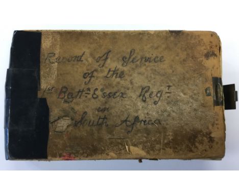
Lot 5149
British Boer War interest. A record of service of the 1st Battalion, the Essex Regiment in South Africa. A small hardbound book with metal clasp closesure, 18cm x 11cm. Taped repairs to spine. Hand written and complied by James Henry Pierson, late of 1st Battl, Essex Regt in 1907 from the Regimental magazine. Complete with newspaper cuttings, letters, hand drawn map, his Death and Marriage certificates, extract from Army orders, Army Pay cert. Plus a modern typed transcript copy of the journal, Essex Regiment Sweetheart badge pin a/f, Lord's Supper book and WW1 Silver War Badge to Name: Rfn B. Jones5th. London. Rgt. Regimental Number:1438. Badge Number:58049


![[Defoe (Daniel)] The Life and Strange Surprizing Adventures of Robinson Crusoe [&] The Farther Adventures..., 2 vol., sev](https://cdn.globalauctionplatform.com/2844b6c2-458c-409c-9df4-aa8000a89c38/59b27655-0f2f-45f5-be68-aa8801143117/468x382.jpg)
Lot 26
[Defoe (Daniel)] The Life and Strange Surprizing Adventures of Robinson Crusoe [&] The Farther Adventures..., 2 vol., seventh edition of vol.1, fifth edition vol.2, engraved frontispiece and 12 plates, folding engraved map, advertisement leaf at end of vol.1, some browning and water-staining, a little cropped affecting a few headlines, B1 of vol.2 defective at fore-edge (repaired), modern morocco-backed marbled boards, 8vo, W. Mears and T. Woodward, 1726.
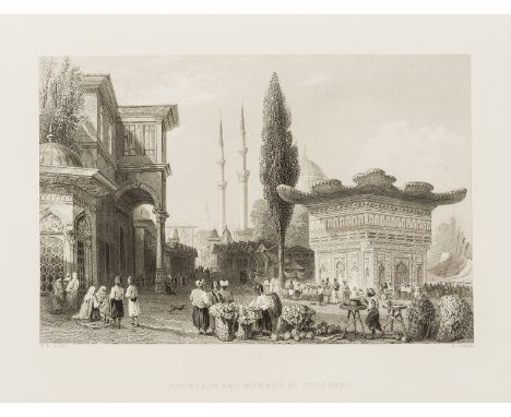
Lot 257
Levant.- Pardoe (Julia) The Beauties of the Bosphorus, engraved portait frontispiece of Pardoe, additional vignette title, portrait of Sultan Adbul Medschid, a map and 81 plates after W.H. Bartlett, occasional spotting, library stamp to verso of printed title, library label removed from front pastedown, contemporary red morocco, gilt, foot of spine little chipped, corners worn, rubbed, [Atabey 922; Blackmer 1254], 4to, Virtue & Co., [c.1840].
Lot 245
Central Asia.- Bell (James Stanislaus) Journal of a Residence in Circassia during the years 1837, 1838 and 1839, 2 vol., first edition, hand-coloured lithographed frontispieces, 8 plates, 1 hand-coloured, 1 folding map, occasional spotting, Eton school prize copy with ink inscription, bookplate, contemporary decorative morocco, [Abbey 355], 8vo, 1840.

Lot 213
Virgilius Maro (Publius) Bucolica Georgica Et Aeneis, 3 vol., half-titles, titles in red and black, engraved vignettes, frontispieces, engraved map, extra-illustrated with c.100 trimmed and laid down plates, light foxing, Springfield MASS library blind-stamps to titles and bookplates to pastedowns, near-contemporary diced russia, gilt arms of Michael Wodhull to covers, rebacked, extremities worn, rubbed, folio, Rome, Zempel, 1763-65; sold not subject to return. ⁂ Michael Wodhull (1740-1816) book collector and translator.

Lot 262
Voyages.- La Billardière (Jacques-Julien) Atlas pour servir à la Relation du Voyage à la Recherche de la Pérouse ..., atlas vol. only, 39 engraved plates only (of 43), all loosely inserted, one or two lacking corners, neatly restored, lacking folding map, ex-library ink-stamp to title, half-calf, rubbed and worn, loss to spine head, folio, Paris, 1811; sold not subject to return

Lot 190
Canals & water supply.- Reasons against the proposed Canals from Swindon to Latton..., 2pp. & map, folio, Oxford, 11th February 1811; and another, an ALs from Matthew Heath to Frederick Booth of Spring Gardens on behalf of the York Buildings Water Works against a proposal for an Act of Parliament by another water works company to provide more water to the area, folds, slightly browned, folio & sm. 4to (2).


Lot 315
Small Selection of WW1 Mapsincluding linen backed, paper trench map, Sheet 57B covering Cambrai and surrounding area. Trenches corrected 24/9/18 ... Similar showing enemy rear organisation, Sheet 57A covering Avesnes, corrected 8/10/18 ... Similar trench map, 51C, covering Baileulual trench marked in the field ... French map Amiens (17) ... Belgium map Valenciennes (12) ... Paper map of Lens. 6 items.


Lot 438
Interesting 25th Dragoons 'Burma' Related Map Case and Contentsconsisting large pattern, khaki webbing map case with front pocket and pencil holders. Large rear pocket. Side with carrying handles. Interior with perspex panels. Both of these with various annotations. Case marked 'Grant'. Complete with linen backed paper map 'Peshawar District and Surrounding Country' ... Similar map 'County Round Nowshera'. This stamped 'B Sqn 25th Dragoons' ... 2 x good photos of the 25th Dragoons in tropical uniforms with black berets. Capt. H.I.H. Grant was 2.1/C B Sqn 25th Dragoons in M3 tanks, present at the Battle of Sinzweya where the Japanese were defeated for the first time.


![Jan Janssonius (1588-1664), by, two-page map, Comitatus Darbiensis [Derbyshire], from volume IV of the Novus Atlas, [Amsterda](https://cdn.globalauctionplatform.com/27793252-3a24-4d64-b7b4-aa8c0028d1b8/318e5e98-f1f7-4e32-9230-aa8f00aed99a/468x382.jpg)
Lot 3611
Jan Janssonius (1588-1664), by, two-page map, Comitatus Darbiensis [Derbyshire], from volume IV of the Novus Atlas, [Amsterdam 1646], upper-right margin with coats of arms of the county aristocracy, lower-left with an allegorical sylvan title cartouche, Latin description to verso, hand-coloured engraving, 39.5cm x 49.5cm
![John Ogilby (1600-1676), by, two-page map, The Road from London to Darby (sic, Derby) [...], Plate 40, [London c. 1675], Baro](https://cdn.globalauctionplatform.com/27793252-3a24-4d64-b7b4-aa8c0028d1b8/ba4affc9-6d95-411d-b797-aa8f00aedabd/468x382.jpg)
Lot 3612
John Ogilby (1600-1676), by, two-page map, The Road from London to Darby (sic, Derby) [...], Plate 40, [London c. 1675], Baroque cresting with royal arms, hand-coloured engraving, 33cm x 44cm; another, similar, The Continuation of the Road From York to Weft-Chester (sic) [...], Compleated (sic) by the Branch from Manchefter (sic) to Derby [...], Plate 40, hand-coloured engraving, 33.5cm x 44cm, each framed en suite, [2]

Lot 3613
John Speed (1551/52 - 1629), by, two-page map, Darbieshire (sic, Derbyshire), Alphabetical Table and Description to verso, [S]old in popes head (sic) Alley by John Sudbury and G. Humble, [London 1627], engraving, contemporaneous hand-colouring, 40.5cm x 53cm Condition Report: Please refer to additional images
-
109198 item(s)/page