We found 109198 price guide item(s) matching your search
There are 109198 lots that match your search criteria. Subscribe now to get instant access to the full price guide service.
Click here to subscribe- List
- Grid
-
109198 item(s)/page


![DARTON, William : [publisher] Dr. Brookes's General Atlas of Modern Geography, 26 ex. 27 double-page hand coloured maps (lack](https://cdn.globalauctionplatform.com/e44547a3-faf4-48f9-916b-a88900eb8f8a/f13eb8ab-c9f9-408c-e24e-91bd37ac9bce/468x382.jpg)
Lot 555
INDIA : 3 manuscript maps, one title, ' Sketch Map Shewing the Principal Roads, Civil, Military and Stations under The Three Residences of Fort William, Fort of George and Bombay, AD 1828." 690 x 540 mm, hand coloured, and mounted on linen. (no cartographer). With other European maps (one in manuscript) and battle plans of a similar period.(9)


Lot 571
RAPIN & TINDELL : A folio of copper engraved maps and plans - Italy(12 plates), France(6 plates), Spain(24 plates), Major General Webb of France, Battles under Count De La Motte(5 plates),Belgium (22 plates) battles, Belgium (17 plates) town plans, town plans various( 8 plates), Ypres, Newport etc., (8 plates) Belgium and Netherlands, (3 plates) Germany etc. c1730s (110).* full list of map condition available on request

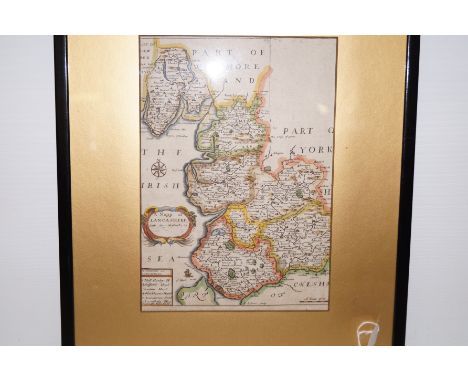
![SAXON, Christopher - Lancastriae : [ Lancashire ] hand coloured map with 'early' hand colouring, 485 x 395 mm, laid down, som](https://cdn.globalauctionplatform.com/e44547a3-faf4-48f9-916b-a88900eb8f8a/5919e315-f135-44c6-a86e-7b5899b70c3d/468x382.jpg)
![SPEED, John - Hartford Shire Described : [ Hertfordshire ] hand coloured map, 510 x 385 mm, Bassett & Chiswell, English text](https://cdn.globalauctionplatform.com/e44547a3-faf4-48f9-916b-a88900eb8f8a/fef38c27-dc4e-49a0-c028-db051e497fd2/468x382.jpg)


Lot 177
Bound Journal Covering Experiences and Details of One Mans Travels in Kashmir from April – May 1903, the well written journal covers his experiences and has a index in the front which lists the chapters of his trip, from Calcutta to Rawalpindi, Rawalpindi to Murree, Murree to Srinagar, at Srinagar, Up the river in House Boat, Camping out in Islamabad and places near, back down the river in House Boat, at Srinagar, on the Dhal Lake, Srinagar to Sambal, Sindh Valley, Manasbal Lake, Sambal to Baramulla, Baramulla to Murree. The journal also includes items of ephemera including business cards of local Kashmir tradesman and businesses. Linen back map attached to the inside pages. Bound in a gilt tooled stiff board covers. 60 pages. An interesting insight into an area where few western people travelled to at this time compared to the main part of the Indian subcontinent.
Lot 203
Collection of Ephemera to 183097 Capt Frederick K Forrester, MBE plus an incomplete manuscript by Lt Edward Rhodes, Pioneer Corps. Warrant to Capt Forrester for his OBE 19/04/1945 and letter for his MBE 25/02/1947. Folder containing newspaper and magazine cuttings, with a focus on the Italian campaign and many on the theme of post-war careers and teaching. Copy of 8th Army News for 03/05/1945 ‘Italy War Over, Hitler is Dead’. Inter-war photo (c.8” x 6”) Chigwell School OTC, Pioneer Corps NCO group photo (c.12” x 8”) signed Maj Spooner 7.10.40, 2 x officer grouping Pioneer Corps photo (c.8” x 6”). 8th Army pamphlets ‘The Post War Training of Teachers’ and ‘Summary of Recommendations of the McNair Report . Supply, Recruitment and Training on Teachers..’, ‘Lecture Notes, Background to the Allies’ from 1944, Ministry of Education wartime pamphlets ‘Notes for Intended Teachers’. War Office booklet Notes on Map Reading 1929 with Amendments to 1939. Army notebook inscribed S/O Forrester, F K, No 13033458 plus several military training pamphlets. Defence Medal Army Form with summary of his wartime service. Letter dated 09/05/1946 confirming Maj Forrester’s appointment to DADL 3 District (Deputy Assistant Director of Labour) in Italy. Envelope of photos from cattle farming family member in Australia, most annotated on reverse. Envelope with unattributed photos of a sinking ship rescue at sea. An incomplete 70pp typed foolscap manuscript telling the story of 142073 L/Cpl Edward Rhodes, later an officer. A senior soldier at the outbreak of war, he had served in WWI, he started in the ranks of the Royal Artillery at a coastal battery in Cornwall. Late 1940 he was selected for officer training and joined the Pioneer Corps, serving in Algeria and Italy with 307 Coy. He writes a series of humorous recollections and reflections on his army service; one being a highly evocative description of Battery night watch on the coast during a bitterly cold, soaking wet, ‘bloody’ night.

Lot 247
13x WW2 Aerial Propaganda Leaflets, including large coloured example of Adolf Hitler standing next to a hangman’s noose on top of a map of Europe with the slogan “FINI LE BEAU REVE DE CONQUERIE L’EUROPE – FINISHED IS THE NICE DREAM IN WHICH EUROPE WAS CONQUERED”, scarce Japanese produced examples urging the Indian forces to rise up against the British, plus examples relating to the V1 and V2 rockets. Various conditions. (13 items)


Lot 156
THEATRE PLAYBILLS - 5 framed theatre broadsides/playbills to include Gloucester Hippodrome (frame 27x78cm), Palace Playhouse Dundee 1916 (frame 33x92cm, damage to glass), West End Theatre Edinburgh (frame 27x75cm), Bijou Variety - St Sampsons, Guernsey (31x41 frame, historical map of Norfolk attached to reverse, frame damaged), Theatre Royal Covent Garden 1775 (frame 24x29cm).


Lot 191
1- Westman, H O: The Spoon: with upwards of one hundred illustrations, primitive, Egyptian, Roman, Medieval, and modern. L, Wiley & Putnam, 1845, first edition. With 8 engraved plated; 288pp. Later full leather; very good; 2- Sheffield Cutlers’ Company’s Industrial Exhibition, July, 1885. 177pp including many adverts; original full leather binding; rubbed; 3- White, W: General Directory of Sheffield. Sheffield, 1845. Original full leather; covers detached; lacking the map; 4- White, W: Gazetteer and General Directory of Sheffield. Sheffield, 1852. Original full leather, rubbed and block split in two; lacking the mapProvenance: The Bill Brown Collection of Antique Cutlery.
Lot 255
Cary's New and Correct English Atlas: Being a new set of County Maps from actual surveys. Exhibiting all the Direct & Principal Cross Roads, Cities, Towns and most considerable Villages, Parks, Rivers, Navigable Canals &c. L, J. Cary, 1793, second edition. With 2 General Maps (Hand coloured) Plus 46 county Maps (partially hand coloured in outline); 48 Maps in all, as called for. 4to., Later half leather over marbled boards and a slipcase. The first general map repaired and the second little trimmed. Plus: A facsimile edition of Speed’s 1614 edition of: Theatre of the Empire of Great Britaine.. Privately printed, no date. Bound by Peter Woodhead, Hertford. Folio, full leather gilt, with slipcase; very good. (2)

Lot 261
PLOT, Robert: The Natural History of Staffordshire. Oxford, Printed at The Theater, 1686. With a frontis linen backed folding map Plus 35 of 37 mostly double-page plates. (lacking plates 24 & 25). 4to. PP450, (x)index. Near contemporary full leather; worn and hinges cracked; plates 3, 5, 21, and 27 have the foredges trimmed; plate 26 torn with small loss to corner; few other plates with small tears (without loss); the odd small stain. Sold A/F not subject to return.
Lot 269
THOMPSON, George: Travels and Adventures in Southern Africa... comprising a view of the present state of the Cape Colony, with observations on the progress and prospects of the British emigrants. S. & R. Bentley for Henry Colburn, 1827, First edition, 4to. PP: xviii, (ii), 493. Complete with one folding lithographed map, Two lithographed plans (one double-page, one folding), Twenty aquatint plates (one double-page) and seventeen wood engravings in the text. Cont. full mottled calf and later spine; little rubbed; occasional foxing and the odd small tear.
Lot 270
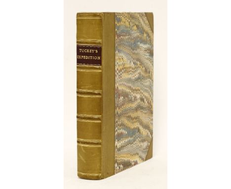
Tuckey, Captain James K: Narrative of an Expedition to explore the River Zaire, usually called the Congo, in South Africa, in 1816.… J. Murray, 1818, First edition. Large folding Map Plus 13 Plates (one hand-coloured). 4to. PP: (viii)including half title and title, Lxxxii (Introduction), 498. Later half leather over marbled boards and new endpapers; very light remains of stamp to verso of title page; contents page torn and with some repair (but complete); some browning and foxing.
Lot 271
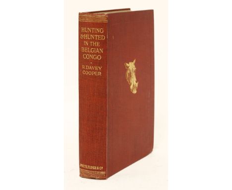
1- Cooper, R D; R. Keith Johnson (Edit.): HUNTING AND HUNTED IN THE BELGIAN CONGO. L, Smith, Elder, 1914, first edition. PP:xvii, (i)blank, 263. With folding map and plates (complete). Original red cloth gilt; covers little rubbed; 2- Lagden, G: The Basutos; in Two volumes. L, Hutchinson, 1909, first edition. PP: xvi, 337, (i)blank; xii, 339-690. All plates and Maps present. Original pictorial cloth gilt; little rubbed; former owners name to verso of frontispieces; occasional foxing; 3- The diary of Henry Teonge: chaplain on board His Majesty's ships Assistance, Bristol, and Royal Oak: Anno 1675 to 1679. L, for Charles Knight, 1825, first edition. PP: Extra engraved title page with vignette, xviii, 327; with a folding facsimile. Cont. full calf; rubbed and hinges cracked. (3)
Lot 274
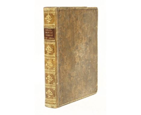
Weld, Isaac Jr.: Travels through the States of North America and the Provinces of Upper and Lower Canada, During the Years 1795, 1796, and 1797. L, John Stockdale, 1799, First edition. Complete with 16 Maps & Plates, including a large folding Hand-Coloured Map of the Northern States of America. 4to. PP: xxiv, 464. Cont. full calf; rubbed; lacking a few of the tissue guards; two small pin holes to the folding map; otherwise very good.

Lot 275
(4 works in one volume): Iobi Ludolfi (Ludolf, Hiob (1624-1704)): HISTORIA AETHIOPICA, SIVE BREVIS ET SUCCINTA DESCRIPTIO REGNI HABESSINORUM, QUOD VULGO MALE PRESBYTERI IOHANNIS VOCATUR. Frankfurt: Johann David Zunner, 1681. PP: (336). complete. Folio; Title-Page printed in red and black. ILLUSTRATIONS: On large engraved folding Map, 8 Engraved Plates (7 folding), plus 2 double-page Tables;Ibid. Ad Suam Historiam Aethiopicam Antehac editam Commentarius in quo multa Breviter dicta fusius narrantur. Frankfurt: Johann David Zunner, 1691. pp: (vi), 30, (ii), 632. complete. Title-page and calendar printed in red and black. ILLUSTRATIONS: 3 Portraits, 9 engraved plates and plans (4 double-page, 3 single page, and 2 half plates); plus a text illustration;Ibid. Appendix ad Historiam Aethiopicam. Frankfurt: Johann David Zunner, 1693. pp: 32. ILLUSTRATIONS: Vignette to title-page, plus One text illustration;Ibid. Appendix secunda ad Historiam Aethiopicam continens dissertationem de locustis. Frankfurt: Johann David Zunner, 1694. pp: (viii), 88. ILLUSTRATIONS: Vignette to title-page, plus 3 engraved text illustrations (one full-page).The four works are bound in one later full vellum volume. Very good copy.
Lot 277
JACQUIN, Nikolaus Joseph, Baron von: SELECTARUM STIRPIUM AMERICANARUM HISTORIA, IN QUA AD LINNAEANUM SYSTEMA DETERMINATAE DESCRIPTAEQUE SISTUNUTUR PLANTAE ILLAE, QUAS IN INSULIS MARTINICA, JAMAICA, DOMINGO, ALIISQUE, ET IN VICINAE CONTINENTIS PARTE, OBSERVAVIT RARIORES. Vindobonae [Vienna], ex officina Krausiana, 1763, First edition. Folio, PP: (x), vii, (v), 284, (xiv)Index, etc., Plus emblematic frontispiece to plate-section and the Plates. ILLUSTRATIONS: engraved vignette of two ships approaching a New World island on title-page, 2 engraved scenic headpieces, numerous woodcut tailpieces, engraved emblematic frontispiece to plate-section depicting Native Americans holding up a banner-map of the West Indies surrounded by Caribbean flora and fauna, Plus 184 engraved full-page plates (numbered I-XXXVII, XXXVII*, XXXVIII-CLXXXIII [also numbered lower right 1-37, 37*, 38-183]; 6 folding) after Jacquin by Jacob Wangner. Leather backed boards; covers worn and front detached; Otherwise a very good and clean copy.


-
109198 item(s)/page