We found 109182 price guide item(s) matching your search
There are 109182 lots that match your search criteria. Subscribe now to get instant access to the full price guide service.
Click here to subscribe- List
- Grid
-
109182 item(s)/page


Lot 2729
Thomas KITCHIN: A New Map of England & Wales. Drawn from Several Surveys & on the new projection . . . 131cm x 109cm, hand-coloured, pictorial cartouche title, Laurie & Whittle, 1794, single sheet. * elaborate and attractive title; scale: approx. one inch to ten miles; canals updated to 1792; shows outline part of Irish and French coasts; Isles of Scilly inset; some engraved text notes.

Lot 2730
Ionnis JANSSON: Suthsexia: vernacule Sussex. 38cm x 52cm within mount, hand-coloured, royal arms and four other armorials, various ships at sea, ca. 1646; sold with Harrison's Map of Sussex, (1791) and two Dover plans - Admiralty Harbour (Proposed Works, 1897), Town and Port (ca. 1840), all framed and glazed. (4)

Lot 2733
C. & J. GREENWOOD: A map of the County of Sussex. From an Actual Survey made in the Years 1823 & 1824 . . . dissected and mounted on linen in 3 sections, each 127cm x 70cm. (and folded to 23cm x 16cm), hand-coloured, scale: 1 inch to mile,contained in the original mottled calf box. Greenwood, Pringle & Co., 1825. * a detailed and most attractive map, depicting the County at the height of the coaching era, recording turnpikes and toll bars, canals, mills, parks, woods and heaths, some individual houses and farms named, etc.; with engraved title, pictorial explanation key and large illus. of Chichester Cathedral. Illustrated.

Lot 2734
John CHAPMAN: Nottinghamshire Survey'd in 1774. 131cm x 87cm, dissected, folded and mounted on linen, hand-coloured, scale: one inch to mile; pictorial engraved title and dedication, engraved explanation key within decorated wreath, folded to 33cm x 23cm in original marbled slipcase, with printed paper label. printed for W. Faden . . . 1785. * a detailed map of the County on the brink of the Industrial Revolution; turnpikes, toll bars and milestones shewn, some individual houses (with owners named) canals, parks, woods, rivers etc.

Lot 2736
Emanuel BOWEN: A New and Accurate Map of Terra Firma and the Caribbe Islands . . . 36cm x 43cm within mount, hand-coloured, engraved cartouche title, (ca. 1750), framed and glazed; Emanuel BOWEN: An Accurate Map of the West Indies . . . approx. 34cm x 44cm, (slipped within the mount), hand-coloured, pictorial cartouche title, ca, 1750, framed and glazed. (2)


Lot 2214
Young, Rev George: 'A History of Whitby, and Streoneshalh Abbey, with a Statistical Survey of the Vicinity' to the Distance of Twenty-five miles, vols 1 and 2, pub Whitby 1817, with fold out map and plates, rebound half calf with marbled boards 2vols Condition Report Click here for further images, condition, auction times & delivery costs

Lot 2218
Young, Rev George: 'A History of Whitby and Streoneshalh Abbey, with a Statistical Survey of the Vicinity' to the Distance of Twenty-five miles, vols 1 and 2, pub Whitby 1817, with linen backed fold out map, fold out and other plates, half calf with marbled boards 2vols Condition Report Vol 1 lacks spine & boards detachedClick here for further images, condition, auction times & delivery costs


Lot 2229
Belcher, Henry: Whitby & Pickering Railway, The Stranger's Guide for a Summer's Day Excursion.... to Whitby, with fold out map pub.1843, Theakston Scarborough, The Strangers & Visitant's Guide to Whitby, pub.1849, The Tourist's Companion, pub.1846, bound as one, calf with marbled boards, 1vol Condition Report Click here for further images, condition, auction times & delivery costs
Lot 2260
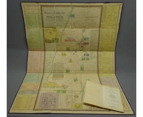
Mimpriss, R: A Chronological & Geographical Chart from The Commencement of the Gospel Narrative to the Ascension of Our Lord (Mimpriss' Chart of The Gospels) nd c1850?, 3rd,ed, folding linen backed map with key in brown cloth slip case with gilt title and twin Royal Arms, 1vol Condition Report Click here for further images, condition, auction times & delivery costs
Lot 2324
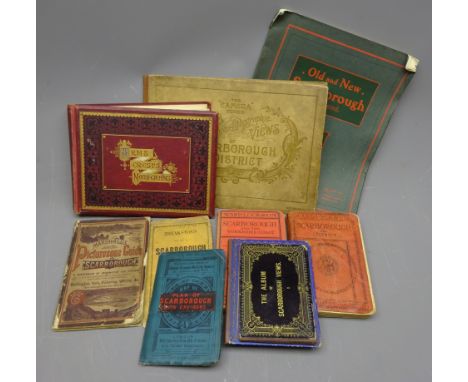
Collection of Scarborough related Ephemera including Theakston's New Map of Scarborough, W.H.Smith linen backed Map of Scarborough with Environs, Marshall's Picturesque Guide to Scarborough, two Albums of Scarborough Views, The 'Camera' Series of Photo-Lithographic Views of Scarborough, Scarborough Old & New Illustrated, Ward Lock 9th ed & 11th ed, both Revised and an Album of Arms, Crests & Monograms with some old Photos. of Scarborough (10) Condition Report Click here for further images, condition, auction times & delivery costs
Lot 2338
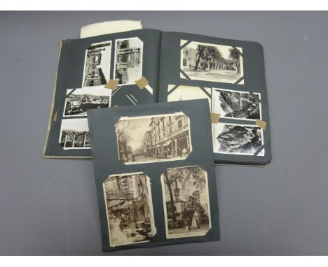
Collection of Post Card mostly post 1900, including RP Horse & Cart Leytonstone, Chromo. Ristorante advert. photos. of 33 Flight in Lecce with Menu. map of Liccata, Schizzo Panoramico map, other photos and Souvenir cards, in album Condition Report Click here for further images, condition, auction times & delivery costs

Lot 2356
Military Ephemera incl. Postcard of POW's at Stalag XXA, photo Postcard of Sgt. E W Shepherd 13th London Regit. B.E Force France one of only six soldiers to be awarded the DCM twice, silk map of Europe, Soldiers Bible, Nazi Panzer Regit, metal badge, other Postcards and Ephemera, qty Condition Report Click here for further images, condition, auction times & delivery costs

Lot 2359
Collection of Trade Cards, mostly Brooke Bond full and part sets ABC Flags of The World, Sunday Times, Edito-Service Cars & Aeroplanes, few silks, Motoring and Hiking map Section BB Scarborough -York area, etc qty Condition Report Click here for further images, condition, auction times & delivery costs

Lot 2373
Hand drawn and coloured Map of the Countries of South America, signed J.D. Young and a similar Map of the geography initialled T.G?, both with Latitude and Longditude lines, pen, ink and pencil, 32.5cm x 42.5cm (2) Condition Report Click here for further images, condition, auction times & delivery costs

Lot 2375
Georg Braun (1541-1622) & Franz Hogenberg (1538-1598) - Hand coloured Map of Gmvnden, engraved Georgius Houfnaglius 1594, with title and vignette from 'Civitates Orbis Terrarum, 35cm x 47cm, in moulded oak frame Condition Report Not checked out of frameExpected centre fold.Some slight staining to sheet.Odd slight stain to plate.Click here for further images, condition, auction times & delivery costs

Lot 2376
Georg Braun (1541-1622) & Franz Hogenberg (1538-1598) - Hand coloured Map of S Ivan Del Fortache with Ierenna below, engraved Georgius Houfnaglius 1565, with Latin text verso No.8 from 'Civitates Orbis Terrarum, 37.5cm x 48.5cm, Condition Report Expected centre fold with repaired 5cm tear at baseSome slight staining to sheet.Odd slight stain to plate.Click here for further images, condition, auction times & delivery costs

Lot 2377
Georg Braun (1541-1622) & Franz Hogenberg (1538-1598) - Hand coloured Map of Conimbria, with crest, vignette and Latin text verso, No.4 from 'Civitates Orbis Terrarum, 28.5cm x 45.5cm Condition Report Expected centre fold.Some slight staining to sheet.Odd slight stain to plate.Click here for further images, condition, auction times & delivery costs

Lot 2378
Georg Braun (1541-1622) & Franz Hogenberg (1538-1598) - Hand coloured Map of Sarbvrgvm with Palatiolvum vulgo Paltz below, with vignettes and Latin text verso, No.26 from 'Civitates Orbis Terrarum, 31.5cm x 38cm Condition Report Expected centre fold.Some slight staining to sheet.Odd slight stain to plate.Click here for further images, condition, auction times & delivery costs

Lot 2379
Georg Braun (1541-1622) & Franz Hogenberg (1538-1598) - Hand coloured Map of Heide with Meldopie below, engraved by Daniel Frese, with crests and Latin text verso, No38 from 'Civitates Orbis Terrarum, 36cm x 37.5cm Condition Report Expected centre fold.Some slight staining to sheet.Odd staining spot to plateClick here for further images, condition, auction times & delivery costs

Lot 2380
Georg Braun (1541-1622) & Franz Hogenberg (1538-1598) - Hand coloured Map of Bardewick, engraved by Daniel Frese 1588, with vignette crest and Latin text verso, No.44 from 'Civitates Orbis Terrarum, 38cm x 50.5cm Condition Report Expected centre fold.Some slight staining to sheet.Click here for further images, condition, auction times & delivery costs

Lot 2381
Georg Braun (1541-1622) & Franz Hogenberg (1538-1598) - Hand coloured Map of Palma , engraved by Daniel Frese 1588, with two vignettes, two medallions and Latin text verso, No.68 from 'Civitates Orbis Terrarum, 38cm x 50.5cm Condition Report Click here for further images, condition, auction times & delivery costs

Lot 2383
Yorkshire. Blaeu (Johannes), Ducatus Eboracensis Pars Orientalis - The East Riding of Yorkshire, hand coloured map with Arms of the Earles of Holderness, in twin glazed Hogarth frame, plate 38cm x 50cm Condition Report Click here for further images, condition, auction times & delivery costs


Lot 2388
'Map of the County round Scarborough in the North & East Ridings of Yorkshire from actual Trigonometrical Survey with Topographical Geological and Antiquarian Descriptions' by Robert Knox of Scarborough pub.1821,republished with additions by him 1849, linen backed folding map, green cloth boards, 1vol Condition Report Click here for further images, condition, auction times & delivery costs
Lot 2389
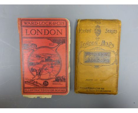
The Handy Series of London Maps, George Philip & Son Ltd 'Rhodes's Picture Map of London 1896' folding linen backed map, and Ward Lock & Co's London Illustrated Guide Book for 1935 with Jubilee Programme, 2vols Condition Report Click here for further images, condition, auction times & delivery costs
Lot 2391
Folding linen backed 6in to 1mile scale Map of Danby Low Moor, pub.Oct 1856, and a similar Map of Egton both with marbled covers a 1911 6in to 1mile OS map of York, and a collection of OS maps mainly Northern England, c1912-1932, 12vols Condition Report Click here for further images, condition, auction times & delivery costs
Lot 2392
19th century hand coloured map of Whitby by Robt. Cooper of York, a 1in to 1mile scale map of Goathland Parish, and a collection of mainly pre-1960 Ordnance Survey maps, 21/2 and 6in to 1mile, including North & West Yorkshire, and a Coastal Map of Hartlepool to Flamborough Head, 17vols Condition Report Click here for further images, condition, auction times & delivery costs

Lot 2393
An Improved Map of Wilt Shire Divided into its Hundreds, collected from the best materials and Illustrated with Historical Extracts .... by Eman Bowen, dedicated to Robert Sawyer Herbert and sold by Tinney, Fleet Street London,1755, some hand colouring, in Hogarth Frame, 54cm x 70cm Condition Report Click here for further images, condition, auction times & delivery costs


Lot 486
AFTER JOHN SPEED Map of Hungary "The Map of Hungari, newly augmented by John Speed, 1626", hand coloured with costume figures and city prospects, 39cm x 51cm, in hogarth glazed frame, together with one other MAP OF "WIRTENBERG" after Georgio Gardner , 38cm x 44cm, in hogarth glazed frame (2)


Lot 113
Herodotus. Historiarum libri IX, parallel text in Latin and Greek, half-title, engraved additional pictorial title with a map of the Aegean seas region, title in red and black and with woodcut printer's device, folding engraved plate, occasional spotting, contemporary blind-stamped vellum, covers with arabesque centre-pieces, lightly soiled and marked, a well-margined, crisp and clean copy, folio, Leiden, Samuel Luchtmans, 1716.
Lot 152
Heathcote & Shirley families, of Hursley Park, Hampshire and Staunton Harold, Ashby-de-la-Zouch, Leicestershire.- Album of letters and documents, including: Heathcote (Sir William, fifth Bt., politician, friend of John Keble, of Hursley Park, near Winchester, Hampshire, 1801-1881) Autobiographical essay, mentioning his friendship with Edward Austen [Rev James Edward Austen (1798-1874), Jane Austen's favourite nephew] and John Keble, manuscript, 12pp., [1829]; and c. 60 other pieces, including: an ALs from Wellington to Heathcote rejecting a request to take his baby on a visit to Stratfield Saye to meet Queen Victoria; 2 ALs.s by John Johnson (1732-1814), architect, for work done at Staunton Harold; document signed by William Murray, first earl of Mansfield (1705-1793), judge and politician; ALs from George Stanhope (1660-1728), Dean of Canterbury; ALs from Richard Hurd (1720-1808), Bishop of Worcester; pen and ink and watercolour wash map of the Mizmaze on St. Catherine's Hill, Winchester, watermarked 1824; letter by Henry Houseman re the sale of Hursley Park; cyclostyled letter from H J jervis to Mr Awdry detailing his son's death during the retreat of the battle of Mons etc., some items removed and some ff. excised, a few small tears or chips to edges, folds, browned, all loosely inserted into an 19th century album, half morocco, gilt, rubbed, folio, 1717-1923.
Lot 159
Elizabeth Barrett Browning's father.- Barrett (Edward Barrett Moulton, plantation owner, 1785-1857).- Ledbury, Herefordshire. The Following Set of Maps of the Parish Ledbury in the County of Hereford... Trophimus Fulljames & William Womack... For Inclosing Lands in the Said Parish of Ledbury and of the General Inclosure Act..., manuscript on vellum signed "EM Barrett", title and 44pp., most ruled in red, 9 hand-coloured maps, all on vellum, title soiled, browned and creased throughout, front free endpaper torn and loose, original half calf and reversed calf boards, worn, red morocco label on upper cover, rubbed, joints splitting at head and tail, spine extensively rubbed, 730 x 860cm., large 4to, 1813.⁂ Includes a detailed map of Hope End, the 500 acre estate in Ledbury where Elizabeth Barrett Browning grew up.
Lot 344
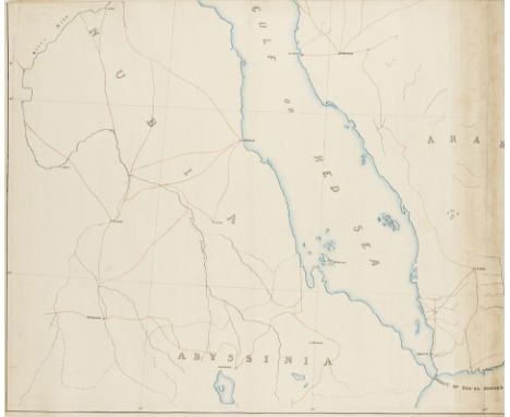
Arabian Peninsula.- Wyld the Younger (James, cartographer and geographical publisher, 1812-1887) [Three-part manuscript map of Arabia and the Persian Gulf], large set of three sheets of outline maps of the South West, South East, and North East quadrants of the Arabian Peninsula, including modern day Saudi Arabia, Yemen, Oman, United Arab Emirates, Qatar, and Bahrain, with part of the south west coast of Iran, also with major cities and trunk roads highlighted including Mecca, pen and ink with watercolour wash over pencil underdrawing, on cream wove paper without watermark, one sheet inscribed 'Drawn by James Wyld Geographer to the Queen & H.R.H. Prince Albert, Charing Cross East', three sheets each approx. 680 x 830 mm. (26 3/4 x 32 3/4 in), some surface dirt, minor nicks and tears to extremities, [circa 1840 and later].⁂ An early three-part manuscript map of Arabia, from one of the most renowned London-based map, chart and globe manufacturers of the 19th century.
Lot 345
Australia.- Japan.- Mishima (Kazuo) Goshu Oyobi Indon, title within woodcut typographic border, wood-engraved map, tape marks to title and final f., some spotting or mostly light foxing, heavier to last f., lightly browned throughout, original pictorial wrappers, internal tape marks, one showing through on back cover, little chipped, 8vo, Tokyo, Mainichi Shinbunsha, 1891.⁂ Rare first edition of this account of a voyage by the Japanese journalist Mishima to Australia in 1889. Having changed at Samoa he arrived in Sydney on the SS Lubeck in December. After a short stay there he travelled by train to Melbourne and remained there until he returned home via India. He discusses horse racing (having lived close to the Caulfield racecourse), the Tasmanians, labour issues and strikes, the history of the exploration of Australia and gold mines.
Lot 346
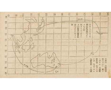
Australia.- Welsh in Australia.- Gwlad yr Aur; neu, Gydymaith yr Ymfudwr Cymreig i Australia, folding lithographed map, with a little hand-colouring, loose, a few splits to folds, some light staining, lower printed wrapper only present, this chipped, 8vo, Caernarvon, H. Humphreys, [1852].⁂ Rare little guide in the Welsh language for those setting out for Australia.

Lot 348
China.- Farrère (Claude) and Charles Fouqueray. Jonques et Sampans, first edition, one of 500 copies on 'velin', frontispiece map printed in colours, hand-coloured lithographed plates and illustrations by Charles Fouqueray, original printed wrappers, housed in cloth chemise and slip-case, a fine copy, 4to, Paris, Horizons de France, 1945.⁂ A charming production giving an account of Charles Fouqueray's voyages from Singapore to Hong Kong, Macao, and Shanghai. It shows the different types of regional vessels.

Lot 351
Greece.- Holland (Henry) Travels in the Ionian Isles, Albania, Thessaly, Macedonia, &c., first edition, engraved map and 12 plates, slightly foxed and browned, bookplate of William Hoskins on front pastedown, original boards, rubbed, corners worn, joints and spine splitting, edges uncut, [Blackmer 825; Atabey 589], 4to, 1815.
Lot 364
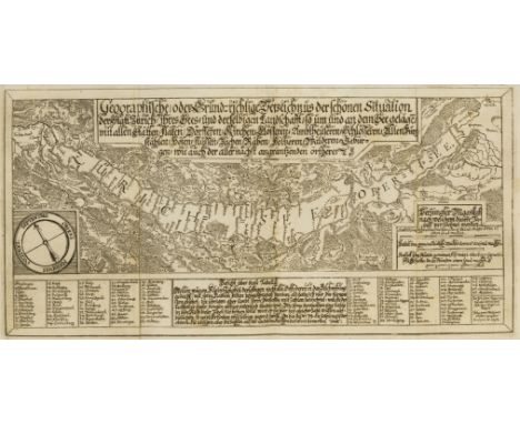
Switzerland.- Lake Zurich.- Escher (Hans Erhard) Beschreibung des Zurich-Sees: wie auch Von Erbauung, Zunemmen, Stand und Wesen loblicher Statt Zurich: Von der Lust- und Nutzbarkeit des Sees..., folding engraved additional pictorial title by Johannes Meyer depicting the city of Zurich and Lake Zurich, title in red and black, engraved folding map of Lake Zurich, one woodcut illustration, some light browning, contemporary orange marbled boards, rubbed, 8vo, Zurich, Johann Rudolf Simler, 1692.⁂ First edition of the first book on the topography and natural history of Lake Zurich. The work is divided into four parts: a history and description of Zurich; the fish and birds of the lake; the villages around the lake; and a history of the region.
Lot 80
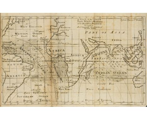
Weather.- Barlow (Edward) Meteorological Essays, Concerning the Origin of Springs, Generation of Rain, and Production of Wind. With a Rational and Historical Account of the Causes and Course of the Tide: Its Propagation thro' the Great Ocean, first edition, lacking A1 (?blank), with 12 folding engraved maps or plans, one bound upside down, another with tear to fold repaired, title soiled, some browning, a few stains, contemporary panelled calf, rubbed, spine slightly worn at head, 8vo, for John Hooke...and Thomas Caldecott, 1715.⁂ Edward Barlow was the inventor of the repeating clock and watch. The work includes a world map of the winds and a double hemisphere map.
Lot 82
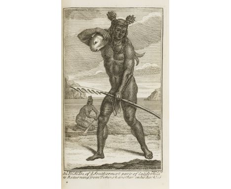
Americas.- California.- Shelvocke (Capt. George) A Voyage round the World by the Way of the Great South Sea, first edition, engraved title-vignette, folding engraved twin-hemisphere map, 4 engraved plates, 2 folding, light water-staining, ink stain to Bb8-Cc3, slight worming to outer margin of final gathering, contemporary panelled calf, a little rubbed, small gouge to lower cover, rebacked, [Cowan pp.581-2; Hill pp.272-3; Howes S383; Sabin 80158], 8vo, for J. Senex, 1726.⁂ Scarce account of Shelvocke's privateering adventures through the Pacific and with what Cowan calls "the fullest account of California, the natives and their features, of any of the old voyagers." The map depicts California as an island and two of the plates show natives of California; there are also early references to Californian gold and Peruvian guano. It has been suggested that Shevlocke's account of the passage around Cape Horn, where a sailor killed an albatross, inspired Coleridge's Rime of the Ancient Mariner.
Lot 83
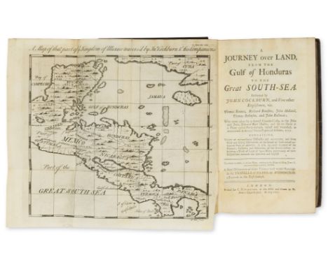
Americas.- Central America.- Cockburn (John) Journey over Land, from the Gulf of Honduras to the Great South-Sea, first edition, folding engraved map, woodcut initials and head- & tail-pieces, 3pp. advertisements at end, occasional browning or soiling, a few stains to verso of B8, engraved bookplate of Tho.Jelf Powys, contemporary sprinkled calf, gilt, a little rubbed, corners slightly worn, nearly rebacked, [Hill 324; Sabin 14095], 8vo, C.Rivington, 1735.⁂ Having been captured by pirates off the coast of Honduras Cockburn and five others escaped and made their way across the isthmus to the Pacific coast, enduring such hardship along the way that this account was for many years regarded as mostly fiction. It also includes 'A Briefe Discoverye of...the Travells of Nicholas Withington, a Factor in the East-Indiase' at end.
Lot 84
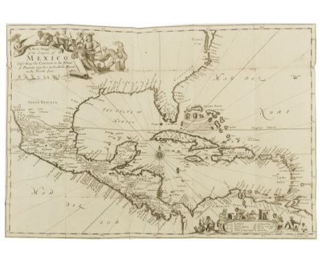
Americas.- Central America.- Gage (Thomas) A New Survey of the West-Indies..., third edition, folding engraved map, lacking final blank, title lightly soiled, a few minor repairs to lower margins, cropped, gilt-stamped circular book-label of William Twopeny, nineteenth century sprinkled calf, gilt, by M.M.Holloway, spine gilt with green morocco label, one compartment worn, [Sabin 26300; Wing G114, cf. Hill 665, first edition of 1648], 8vo, by A.Clark...to be sold by John Martyn, Robert Horn and Walter Kettilby, 1677.⁂ The first non-Spanish description of the Spanish territories in the New World. Gage spent a dozen years in Central America, living for much of the time amongst the Indians.
Lot 87
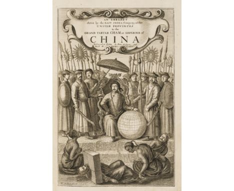
China.- Nieuhoff (Jan) An Embassy from the East-India Company of the United Provinces, to the Grand Tartar Cham Emperor of China, translated by John Ogilby, second edition, additional engraved pictorial title by Hollar, title in red and black, folding engraved map, folding plan of Canton and 16 plates only (of 17, lacking ?portrait of Ogilby), numerous engraved illustrations in text, wide margins, lacking list of plates, title lightly soiled, folding map browned at fold, occasional offsetting to or from illustrations, a few small rust-spots (one causing tiny hole to illustration on 3D1, with early 19th century manuscript presentation note tipped to front pastedown, contemporary sheep, worn, [Cordier Sinica 2347; Wing N1153], folio, by the Author, 1673.
![Middle East.- Doughty (Charles M.) Travels in Arabia Deserta, 2 vol., first edition, [one of 500 copies], half-titles, foldin](https://cdn.globalauctionplatform.com/095499c2-54c5-4dfc-952f-aa0200d64a2c/d4dbd067-0b9f-42ed-8397-aa0600cbdab0/468x382.jpg)
Lot 88
Middle East.- Doughty (Charles M.) Travels in Arabia Deserta, 2 vol., first edition, [one of 500 copies], half-titles, folding plates, illustrations, folding colour map in pocket at end of vol.1, original pictorial green cloth, gilt, uncut & unopened, spines lightly faded, a little mottling to boards, vol.2 with split to upper joint and corners bumped, 8vo, Cambridge, 1888.⁂ Classic work on the exploration of Arabia with so much information on the topography of the area that it was used as a text-book by the British army during the Arab Revolt. There are also detailed descriptions of the Bedouin tribes and their customs.

Lot 91
World.- Gibson (John) Atlas Minimus, or a New Set of Pocket Maps ... of the known World... Revis'd, Corrected and Improv'd by Eman: Bowen, engraved throughout with frontispiece, calligraphic title, preface leaf, index leaf and 52 maps hand-coloured in outline (16 relating to the Americas), contemporary ink inscription to verso of frontispiece, a little soiled, twin-hemisphere map lightly spotted, contemporary calf, rubbed, spine ends slightly worn, 16mo, by J. Newbery, 1758.
![World.- Morden (Robert) [Geography Rectified: or, A Description of the World], maps only, no title or text, comprising double](https://cdn.globalauctionplatform.com/095499c2-54c5-4dfc-952f-aa0200d64a2c/5fd88bec-2120-4650-8b6a-aa0600cbe30a/468x382.jpg)
Lot 92
World.- Morden (Robert) [Geography Rectified: or, A Description of the World], maps only, no title or text, comprising double-page engraved 'Catalogue of Mapps in This Booke' and 79 double-page engraved maps, maps all with attractive bright outline hand-colouring in contemporary hand (sheets c.150 x 165mm.), all mounted on stubs, rather soiled and browned, some offsetting or staining, a few maps with tear to fold, one or two others with marginal tears or defects, 'Catalogue' with wormhole affecting border, contemporary mottled calf, rubbed, corners worn, rebacked preserving old red roan label "Book of Maps", 8vo, n.p., [late 17th century]; sold not subject to return⁂ Bound volume of maps from Morden's Geography Rectified including a twin hemisphere map and 17 maps of the Americas, with a general map of America showing California as an island. The work was first published in 1680 with 62 maps and a second, enlarged, edition in 1688 with 78 maps. The 'Catalogue' lists 78 maps but this volume contains an additional map 'Turkey in Europe' following that of Greece.
![ƟRichard Adams, Watership Down, first edition, signed by the author [London, Rex Collings, 1972]complete with large folding m](https://cdn.globalauctionplatform.com/61d004a3-74d2-402a-81aa-a9f500d7e3ea/61a17908-d95d-4fec-abcc-a9f500e305cd/468x382.jpg)
Lot 1
ƟRichard Adams, Watership Down, first edition, signed by the author [London, Rex Collings, 1972]complete with large folding map, title signed “Yours sincerely, Richard Adams”, some faint scattered spotting to preliminary and penultimate leaves and pastedowns, original brown cloth, gilt vignette to upper cover, spine lettered in gilt, corners and spine ends a little bumped, lower cover with with some discolouration, volume with slight shelf lean, original dust-jacket, spine slightly faded, extremities with some very faint finger-soiling, a few closed tears along creases and a few small chips to head and tail of spine with fractional loss, unclipped, overall an excellent copy, 8voAn excellent copy of the author's first landmark novel. Ɵ Indicates that the lot is subject to buyer’s premium of 25% exclusive of VAT (0% VAT).
![Ɵ J.R.R. Tolkien, The Hobbit, or there and back again, first edition, first impression [London, George Allen & Unwin, 1937]co](https://cdn.globalauctionplatform.com/61d004a3-74d2-402a-81aa-a9f500d7e3ea/fd148bf6-621d-4830-8c54-a9f500e34285/468x382.jpg)
Lot 69
Ɵ J.R.R. Tolkien, The Hobbit, or there and back again, first edition, first impression [London, George Allen & Unwin, 1937]complete, “1937” printed on the titlepage, frontispiece in black and white, original map endpapers and pastedowns, very slightly browned, original green decorated cloth, with Tolkien’s own mountain and dragon design, very slight shelf lean otherwise excellent condition, original first impression dust-jacket with “Dodgeson” (better known as Lewis Carroll) manual correction on lower flap, some very small restoration to small scuff marks, overall a fine and remarkably clean copy, 8voAn exemplary copy of the true first edition of Tolkien’s debut novel, first printed in September 1937 with a limited run of 1500 copies. It offered its reader, exhausted by the horrors of the First World War and fearful of the next, an escape into the imaginary lands of Middle Earth, travelling with them through the Shire, Rivendell and Mirkwood, leading to the climatic confrontation with the dragon Smaug under the Lonely Mountain. The Hobbit proved wildly popular and had completely sold out by December of the same year. The second impression soon followed, with a print run of 2300 copies, including new additions of colour plates and additional maps. The second printing bears the same date of publication “1937” on the titlepage and is often misidentified as the first edition of the work.Its popularity grew steadily on a global scale since its publication, with numerous editions published, and radio and television versions realised as far afield as Finland. In 2012-2014 it was once again honoured as a seminal work of fantasy literature, in Peter Jackson’s trilogy of film adaptations.As the work was intended to be book for children, few first edition copies emerge in the same outstanding condition as the present example. Ɵ Indicates that the lot is subject to buyer’s premium of 25% exclusive of VAT (0% VAT).


-
109182 item(s)/page