We found 109182 price guide item(s) matching your search
There are 109182 lots that match your search criteria. Subscribe now to get instant access to the full price guide service.
Click here to subscribe- List
- Grid
-
109182 item(s)/page


Lot 6
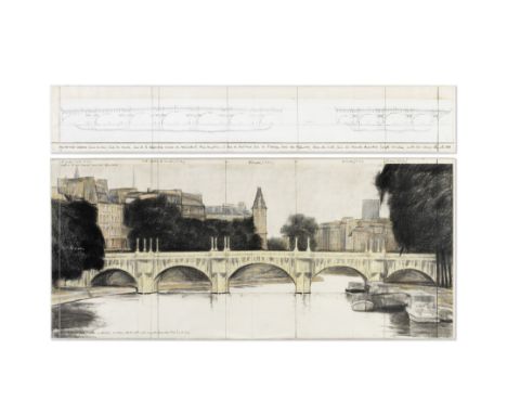
Christo (American, born 1935)The Pont Neuf Wrapped (Project For Paris), in two parts 1979 signed, titled and dated 1979 on the upper panel; variously inscribed on the reverse of each panelpastel, wax crayon, charcoal, graphite and printed paper on card laid on board, in a Perspex frameUpper Panel: 38 by 244 cm.14 15/16 by 96 1/16 in.Lower Panel: 107 by 244 cm.42 1/8 by 96 1/16 in.Footnotes:ProvenanceCarl Flach, SwedenSale: Sotheby's, London, Post-War and Contemporary Art, 3 December 1992, Lot 68Galerie Bernard Cats, BrusselsAcquired directly from the above by the present owner in 1994Over the course of one of the most enchanting and beloved artistic careers – famed for producing some of the greatest monumental and dramatic works of public sculpture to ever be realised – American artist Christo and his wife Jeanne-Claude have redefined the notion of public sculpture, bringing their 'wrapped' projects to cities including Berlin, Chicago, Milan, and Paris. Presented here are two sterling examples of Christo's preparatory artworks for The Pont Neuf Wrapped and The Umbrellas, each project realised in 1985 and 1991 respectively. Internationally lauded and collected by museums that include the Art Institute of Chicago, the Cleveland Museum of Art, USA, and the Tate collection, London, the Centre Pompidou in Paris will play host to a major retrospective of Christo and Jeanne-Claude, opening in March 2020, before presenting one of their most significant and highly anticipated wrapped monuments in September; covering the Arc de Triomphe in Paris with 25,000 square meters of fabric for a period of 16 days. Contemplative and beautiful, Christo's practice emerged from the Nouveau Réalisme movement in Paris in the early 1960s alongside artists including Yves Klein and Jean Tinguely. Having fled the Eastern Bloc, escaping from Czechoslovakia to Vienna in 1957 before making his way to the French capital, the artist found his quintessential style early on, wrapping cans, bottles, shoes, and chairs in his Paris attic studio, before meeting his lifelong collaborator and wife Jeanne-Claude in 1958. Offered for sale are two preparatory renderings of a pair of enormously complex projects Christo and Jeanne-Claude would undertake years after their conception. The Pont Neuf Wrapped (Project For Paris) (1979) – one if the largest Christo works to ever come to market – and The Umbrellas (Joint project for Japan and USA) (1990) illustrate the extravagant conceptual mind that made Christo and Jeanne-Claude two of the most celebrated and admired creative visionaries of the last half century. The Pont-Neuf bridge was first completed in July 1606 and is the oldest bridge crossing the river Seine in the French capital. An icon of Paris, joining the left and right banks and the Île de la Cité for over 400 years, it has been immortalised in paint by J.M.W. Turner, Pierre-Auguste Renoir, and Camille Pissarro alike. Joining such a canon of artists to tackle this historical site, the present work by the artist is a rare, large-scale, two-part study for the proposed project that took ten years of negotiations and two rejections before it was finally executed in 1985. Turning one of the most important pieces of architecture in Paris into a uniform façade of folds and bindings, Christo and Jeanne-Claude drew attention to the history, the design, and the mythology of the 'City of Light', highlighting the building blocks of a culture and a nation; appreciating them by veiling them. Documenting the ephemeral, 14-day event, the energetic diptych, The Pont Neuf Wrapped (Project For Paris), depicts a charming blend of studied, expressive and technical marks, combined with notes and comments by the artist's hand, capturing the committed and all-encompassing approach to what would become one of the duo's most iconic wrapped monuments. A thought-provoking and more politically weighted piece, The Umbrellas (Joint project for Japan and USA) depicts one of Christo and Jeanne-Claude's most elaborate and poignant works of public sculpture, ambitiously constructed between two continents either side of the Pacific Ocean in 1991. From 9th October that year for 18 days, 3100 oversized umbrellas standing at little over 6 meters high, divided between two valleys in Japan and California, USA, were opened and stood silently and proudly as objects that sheltered and mirrored one another across nations that had previously known intolerable war against one another. Often rebutting the political or historical reading of their work, the couple's temporary monuments nonetheless consistently nudge a reading of them as being bound to their sites and their shapes, drawing attention to their location and social currency. In the present work, Christo's Japanese umbrellas dance through the valley of the Sato River, wonderfully depicted in vivid hues of green and blue, inscribed exuberantly in pencil on paper, alongside a technical map of the lowland in the Prefecture of Ibaraki. As much technical drawings as they are visions of a project to-be, the two diptychs by Christo offered here are superlative examples of the artists' fleeting monumental projects and their lasting preparatory studies. Works of art in their own right, they stand as exquisite landscapes that chart the magnificent and provocative impact Christo and Jeanne-Claude have had, not just as great sculptors, but as an artist-duo who have made history and culture their very medium.This lot is subject to the following lot symbols: * AR* VAT on imported items at a preferential rate of 5% on Hammer Price and the prevailing rate on Buyer's Premium.AR Goods subject to Artists Resale Right Additional Premium.For further information on this lot please visit Bonhams.com
Lot 156
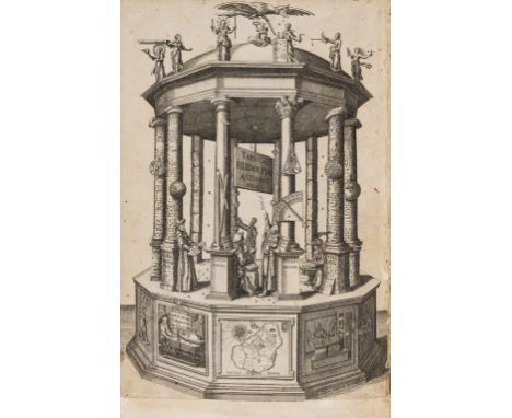
Kepler (Johannes) Tabulae Rudolphinae, quibus Astronomicae Scientiae, Temporum longinquitate collapsae Restauratio continetur, first edition, additional engraved title becoming loose, L2/L3 double-page letterpress table with partial hand-colouring, folding manuscript table of logarithms bound in at end, a few margins repaired or remargined, including engraved title at foot and folding margin of k3, with some letters of side-notes supplied in manuscript, some worming, mostly marginal, a few gatherings (including "Sportula", sig. q, issued in 1629) browned, later half calf, rubbed, [Tomash & Williams K27; Houzeau & Lancaster 12754; Norman 1208], folio, Ulm, Jonas Saur, 1627.⁂ "The foundation of all planetary calculations for over a century." (Sparrow, Milestones of Science). Tycho Brahe asked Kepler to complete his Rudolphine tables, shortly before the former's death in 1601 - the resultant work, based on Kepler's discovery of the laws of planetary motion and on his introduction to logarithms, produced far more accurate positions than those in earlier tables. This copy includes the 4-leaf "Sportula genethliacis missa" published in 1629, but does not have Bartsch's appendix or the world map, both issued after 1627.


Lot 104
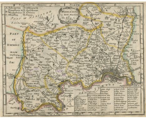
Johannes Blaeu (Dutch, 1596-1673), Staffordshire, Staffordiensis Comitatus, vulgo Stafford Shire, published Amsterdam, [1645 or later], decorative cartouche, hand coloured engraved map, plate size 41.5 x 51cm.; 16.25 x 20in, together with another map of Staffordshire by Robert Morden, hand coloured engraving, 44.5 x 38cm, 17.5 x 15in (2).


Lot 27
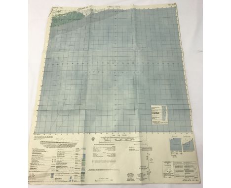
World War Two map collection includes five maps Newton Stewart War Revision 1940, England South 2nd War Revision 1943, East Anglia 2nd War Revision Military Sheet 9, 1943, Reading and Newbury 2nd War revision sheet 113 , 1942, North Midlands and Lincolnshire graticule edition 2nd War revision Air sheet 6, 1943 and Bergen Norway 1973 copy. Good Condition. We combine postage on multiple winning lots and can ship worldwide. UK postage from £4.99, EU from £6.99, Rest of World from £8.99.


Lot 3060
1936 Isle of Man TT programmes and ephemera, comprising Junior, Lightweight and Senior T.T. official programmes, Races 1936 Programme and Scoring Card, T.T. 1936 Map of Course, three The Motor Cycle magazines Vol. 56 numbers 1731,1732, and 1733, Motor Cycling magazines, June 24 1936 and July 1st 1936, three issues of The T.T. Special newspapers, June 15th, 18th and 19th 1936 and a Ramsey Courier newspaper, June 19th 1936.


Lot 127
HARDY (THOMAS)Tess of the D'Urbervilles. A Pure Woman, ONE OF 325 LARGE PAPER COPIES SIGNED BY THE AUTHOR, 41 wood-engraved plates and illustrations by Vivien Gribble, folding map by Emery Walker, uncut in publisher's vellum-backed boards, dust-jacket, jacket slightly frayed at head of spine and corners, but overall a fine copy, 4to, Macmillan, 1926This lot is subject to the following lot symbols: •• Zero rated for VAT, no VAT will be added to the Hammer Price or the Buyer's Premium.For further information on this lot please visit Bonhams.com
Lot 149
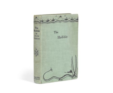
TOLKIEN (J.R.R.)The Hobbit or There and Back Again, FIRST EDITION, FIRST IMPRESSION, frontispiece and 9 plates or illustrations (all but one full-page), map endpapers (printed in red and black) by the author, publisher's green cloth, lettered and decorated in dark blue, corners of spine slightly worn [Hammond A3(a)], 8vo, George Allen & Unwin, [1937]Footnotes:The Hobbit was published on 21 September 1937 in an initial print run of 1500 copies that was sold out by 15 December of that year.Provenance: Michael Tisdall (gifted to him at the time of publication), pencil inscription on front free endpaper; by descent to the present owner.This lot is subject to the following lot symbols: •• Zero rated for VAT, no VAT will be added to the Hammer Price or the Buyer's Premium.For further information on this lot please visit Bonhams.com
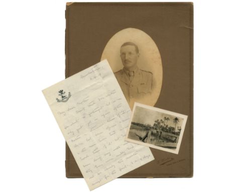
Lot 154
WORLD WAR I - MESOPOTAMIACollection of letters, photographs and ephemera relating to the career of Major James Wickham Ley, D.S.O., of the 2nd, attached to the 7th, Battalion (The Prince of Wales's) North Staffordshire Regiment, comprising over 70 letters to his mother and other members of his family from various postings, Blomfontein and Johannesburg in the Boer War, Simla, Lucknow and the North West Frontier, Basra, Mesopotamia ('Mespots') and Baghdad in the First World War, c.300 pages, with envelopes, dust-staining and usual signs of wear, 4to and 8vo, South Africa, India, Mesopotamia and Persia, 13 October 1897 to 22 September 1918; with some 70 photographs of family and camp life, his commission signed 'Victoria RI', a Stanford's map of Lower Mesopotamia, other personal papers and newspaper cuttings, with documents relating to his death, etc. (quantity)Footnotes:'I JUST GOT A BULLET THROUGH THE LEFT SHOULDER & SHALL BE ALRIGHT AGAIN VERY SOON': correspondence from a career-soldier. Many of Major Ley's letters from India describe a seemingly never-ending round of parties and sporting events, whilst making light of impending skirmishes with the Afghans ('there may be a bust up...'), possibly to spare the feelings of his mostly female correspondents to whom he is most solicitous ('I think you're quite right that Surbiton is not a very healthy place for anybody'). Weeks later he is in 'Mespots' with Expeditionary Force D, tormented by insects and sandstorms and writes with evident frustration at the lack of activity ('we've been doing practically nothing here & it looks as if we shall go on doing it...') and relying on a trickle of news from the Western Front ('I see the French are using gases and burning liquid which seems rather a pity but suppose it has got to be done...'). He was finally selected to join the so-called 'Hush-Hush' army, Dunsterforce, which suffered a heavy defeat at Baku ('Didn't take my boots off for over ten days and had a pretty worrying time of it...') and was forced to evacuate (in his last letter he writes 'I have lost all my kit... I've been through so many stages... it would be difficult to know where to begin...'). At the battle he held a crucial position with a handful of men, enabling others to escape but enduring heavy losses of his own battalion. The responsibility for this was too much and, suffering from depression, James Ley took his own life on 22 October 1918.For further information on this lot please visit Bonhams.com

Lot 26
STAFFORDSHIRE – CHETWYND FAMILY AND INGESTRECalligraphic richly illustrated volume on vellum tracing the deeds and architectural accomplishments of the Chetwynd family of Ingestre Hall, compiled for the antiquary and friend of Sir Christopher Wren, Walter Chetwynd, by his protege Gregory King (later map-engraver to John Ogilby and pioneering economist), with title-page: 'Chetwyndorum Stemma./ sive/ Chetwyndianæ Familiæ/ de Ingestre in Agro Staffordiensi/ Ac olim de Chetwynd in com. Salop./ Successio./ Ex ipsis Autographis/ penes Walter Chetwynd Arm./ deducta./ Et/ Insignis, Sigillis, aliisq., ejusdem Familiae Monumentis/ illustrata./ Ao. Dni. M.DC.LXXXX.', transcribing each deed, including petitions and wills (including, for example, that of Sir Thomas Littleton, 1481: 'Item I will that my wife have a Bason of Silver, in the middest whereof is her Armes and mine, and an Ewer of Silver; two great Salt sellers with a kever, a standinge playn gilt peece, vj bolls of Silver, a standinge peece with a Cover, a flatt low gilt peece with a cover, ij peeces of Silver, one coveringe another, a Powder Box of Silver, a Paxborde, ij Cruets and a Sacring bell of Silver. Item that William Littleton my sonne and heire shall have a deepe washing Bason of Silver...'), illustrated in the margins with nineteen watercolour drawings of seal impressions, and within the text four pen-and-ink studies of monumental effigies, tombs and the like (on pp.22, 64, 66 and 84); two leaves unpaginated, one of which has been left incomplete (between pp.36 and 37 and 82 and 83), a further four leaves unpaginated followed by three blank leaves following p.92 and before the beginning of the second section at p.93; the second half of the volume containing pen, ink and wash drawings of Ingestre and the family property at Grendon (Warwickshire), beginning at p.93 with 'A Prospect of the Front of the Manour house at Ingestre'; followed by 'A Prospect of the South Side of the Parish Church of Ingestre Erected Anno 1677' and 'A Prospect of the West end of the said Church' (p.95); followed by the mural monument 'On the North side of the Chancell of the Parish Church of Ingestre' (p.96), 'On the South side of the said Chancell' (p.97), the wording of the 'Memoriae sacrum Walteri Chetwynd' [then still living] left blank; the inscription repeated on p.98; eight armorial windows 'of the Chancell of the Parish Church of Ingestre', with a key to the families represented (p.99); the mural monument 'In the South Ile of the Parish Church of Grendon' (p.100); and another 'In the same South Ile' (p.101) and 'In the foresaid South Ile' (p.102) [these three erected by Sir Walter Chetwynd, see VCH Warwickshire, Grendon Parish], followed by two blank vellum sheets; bound at the end, on paper, are figures of forty-three seals in pen-and-ink (pp.105-6), with four paper leaves at the end left blank, 114 vellum leaves (102 paginated plus 12 unnumbered or with duplicate pagination), bookplate of Ingestre Hall (with the Talbot crest surrounded by the Garter and surmounted by an earl's coronet, for Charles Chetwynd-Talbot, 2nd Earl Talbot, 1777-1849, created KG in 1844), later endpapers, fine late seventeenth century morocco, elaborately gilt with floral and foliate devices and drawer-handle borders, with the arms of Sir Walter Chetwynd at centre, lightly rubbed, folio (360 x 275mm.), 1690Footnotes:A CONTEMPORARY RECORD OF THE ONLY WREN CHURCH OUTSIDE LONDON, the present volume having been compiled at the behest of Sir Walter Chetwynd FRS, who is thought to have commissioned the church from his friend Sir Christopher Wren; the volume itself compiled for Chetwynd by his protégé Gregory King, later renowned as map-engraver to John Ogilby and pioneer economist. (It will be noted that Chetwynd's own monument, on the south side of Ingestre chancel, has been left blank under the heading 'Memoriae sacrum Walteri Chetwynd': he was to die two years later, on 21 March 1692.)In the words of Sir Nikolaus Pevsner: 'For churches the locus classicus [in Staffordshire] is of course Ingestre, which can with full confidence be ascribed to Wren. It is dated 1676, and in it one breathes an air of harmony and calm not attained by any church in the county for well over a century after' ( The Buildings of England, Staffordshire, 1974, p.28). While the church and its monuments have happily survived, the hall itself was severely damaged by fire in 1882 and largely rebuilt.Although this book was compiled under the aegis of Chetwynd, the actual work was begun, and probably carried through, by Gregory King (1648-1712), who was later to become well-known as a herald, antiquary and map-engraver to John Ogilby. He is now chiefly remembered, however, for his work as the 'first great economic statistician' (Some British Empiricists in the Social Sciences 1650-1900, 1997, p.xxii ): 'King's political arithmetic was highly original and he had no peer until the flowering of the nineteenth-century statistical movement. In the first place he was distinguished by tying his calculations closely to detailed available evidence, often by imaginative use of tax records, though his earlier work as a herald and cartographer was also vital. If King's political arithmetic was more ambitious than that of any other contemporary it was also more securely based' (Julian Hoppit, 'Gregory King', ODNB).The present volume appears to have been, to a large degree at any rate, assembled by King at the start of his career: 'A manuscript compendium of Chetwynd deeds entitled 'Chetwyndorum stemma' and written on vellum is dated 1690. It also contains tricks of seals and drawings of Ingestre Hall, the new church and monuments there and in Grendon church. The first part, which concludes with the Chetwynd pedigree to 1671, is evidently the work for which Gregory King was brought to Ingestre in 1670. Its continuation, which includes further medieval deeds and documents relating to public offices held by Chetwynd from 1662 to 1689, is also probably by Gregory King. Finally in September 1692 the chaplain Charles King stated that Chetwynd had done all that he intended on the antiquities of Staffordshire' (M. W. Greenslade, 'Walter Chetwynd', ODNB). The quality of the work suggests also that Gregory King could well have been responsible for its execution; although his near namesake, Charles, the chaplain, did early antiquarian work for Chetwynd and was also, to boot, a fine botanical illustrator (see Greenslade, op.cit.). Quite how the volume was assembled is not clear. Not only are there several pages bearing duplicate pagination, and others bearing none at all, but one of the final unnumbered leaves bears the pencilled heading, in what appears to be a late seventeenth century hand, 'Before page 93'. While the binding is clearly contemporary, the marbled endpapers are more characteristic of the turn of the eighteenth and nineteenth centuries. This impressive volume has remained in the family to this day.This lot is subject to the following lot symbols: •• Zero rated for VAT, no VAT will be added to the Hammer Price or the Buyer's Premium.For further information on this lot please visit Bonhams.com
![BIBLE, IN ENGLISH, BISHOPS' VERSION[The Holie Bible], 4 parts (of 5, lacking all New Testament) bound in 2 vol., black lette](https://cdn.globalauctionplatform.com/2972e28e-fe0a-4dc9-af06-ab5800d0acdb/45eeb21d-f4e8-46dc-84db-ab6700b75aa5/468x382.jpg)
Lot 34
BIBLE, IN ENGLISH, BISHOPS' VERSION[The Holie Bible], 4 parts (of 5, lacking all New Testament) bound in 2 vol., black letter, title to part 4 only, several large woodcut illustrations, numerous large initials, lacks all 25 preliminary leaves, folding map, 16 leaves of parts 1 and 2, and 3 leaves of part 3, a few leaves shaved touching text, small hole affecting 2 illustrations, a few small stains but generally clean on heavy paper, nineteenth century half calf, upper covers detached, worn [ESTC S121300; Herbert 132], folio (390 x 267mm.), [Richard Jugge, 1572]Footnotes:The second folio edition of the Bishops' Bible, a revision of the Great Bible version, undertaken by Matthew Parker, Archbishop of Canterbury, being a close reprint. Several of the large decorative initials represent classical subjects, and were re-used from an edition of Ovid's Metamorphoses. Provenance: 'This book appertyneth to Suffield Church. Joshua who the Hebrews called Jehovah', sixteenth century ownership inscription at end of Joshua; Charles James Tabor (born 1864), bookplate.This lot is subject to the following lot symbols: •• Zero rated for VAT, no VAT will be added to the Hammer Price or the Buyer's Premium.For further information on this lot please visit Bonhams.com
Lot 64
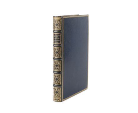
MEDINA (BALTHASAR DE)Chronica de la santa provincia de San Diego de Mexico, de religiosos descalcos de N.S.P.S. Francisco en la Nueva-Espana, FIRST EDITION, title within typographic border, additional engraved title (folding) with border incorporating scenes of martyrs of New Spain, one engraved map, both by Antonio Ysarti, large woodcut arms in text, woodcut decorative initials and ornaments, without final blank, blue crushed morocco gilt, by Lortic fils, covers with 3-line fillet border, elaborately tooled in six compartments within raised bands, g.e., purpose-made slipcase [Palau 159373; Sabin 47336, 'A volume of extreme rarity'; Wagner, Spanish Southwest 55], folio (278 x 195mm.), Mexico, Juan de Ribera, 1682Footnotes:An important account of seventeenth century missions to New Spain, including that of Antonio de Arteaga. Born in Mexico Balthasar De Medina was a Discalced (or 'Barefoot') Franciscan, and also described the political and geographical account of the the Province of San Diego. The decorative title-page (including images of several martyrs of New Spain, whose lives are described in the text), and the decorative bird's-eye view map of the San Diego area were engraved by Antonio Ysarti, constituting 'the earliest specimen of copperplate engraving done in Mexico' (Sabin).This lot is subject to the following lot symbols: •• Zero rated for VAT, no VAT will be added to the Hammer Price or the Buyer's Premium.For further information on this lot please visit Bonhams.com
Lot 78
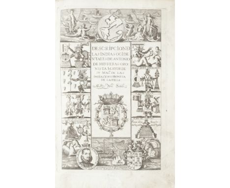
HERRERA Y TORDESILLAS (ANTONIO DE)Descripcion de las Indias occidentales de Antonio de Herrera coronista mayor de su Magd. de las Indias, y su coronista de Castilla, 14 double-page or folding engraved maps, mounted on stubs (slight brown mark where joined); Historia general de los hechos de los Castellanos en las islas i tierra firme del mar oceano... Decada primera, 2 parts in 1 vol. (only, of 4), each with engraved pictorial title with borders of deities, conquistadors, battle scenes etc. (the first with margins restored), contemporary limp vellum, titled in ink on spine, crinkled and soiled, later endpapers [Borba de Moraes, I:401; Palau 114287-8; Sabin 31541, 31546; Wagner, Spanish Southwest 12k-l.], folio (299 x 205mm.), Madrid, en la Oficina Real de Nicolas Rodriguez Franco, 1725-1726Footnotes:The Descripcion de las Indias Ocidentales, with 14 maps of the Americas, is here bound before the first of the eight 'Decadas' of the Historia general, of which it forms a part. The edition is Gonzales Barcia's reprint of the original edition of 1601-1615, generally thought to be 'the best edition' (Sabin). The maps include Descripcion de las Yndias Ocidentales (the earliest printed Spanish map to depict the complete continents of North and South America), Descripcion de las Indias del Poniente (the First Spanish Map of Southeast Asia, China and the Philippines), Descripcion De las Yndias del Norte (the interior with little or no detail due to the Spanish policy of secrecy, this edition characterised by the naming of Florida in two places).This lot is subject to the following lot symbols: •• Zero rated for VAT, no VAT will be added to the Hammer Price or the Buyer's Premium.For further information on this lot please visit Bonhams.com

Lot 89
AMERICASLAURIE (ROBERT AND JAMES) A New Map of North America, and the West India Islands, divided according to the Preliminary articles of Peace signed at Versailles, 20 Jan. 1783, wherein are particularly distinguished The United States and the several Provinces, Governments &c which compose the British Dominions, large historiated cartouche, inset maps of California, and Baffin and Hudson Bays, 1794; A New Map of the Whole Continent of America, Divided into North and South and West Indies, Wherein Are Exactly Described the United States of North America, large decorative cartouche, inset map of 'countries adjoining to Baffins & Hudsons Bays', 1794, large engraved maps, each on 4 sheets joined as 2 horizontal sheets, hand-coloured in outline, total dimensions approximately 1040 x 1020mm., Laurie & Whittle, 12 May 1794--ROBERT (HENRY) A General Chart: Exhibiting the Discoveries Made by Capt. James Cook in This and His Two Proceeding Voyages, piece torn away from upper margin (with part loss of the letter 'E' in 'General' of title caption), 610 x 935mm., [W. Faden, c.1797]--TALLIS (JOHN, publisher) North America; British America; Western Hemisphere; Mexico, California and Texas, by J. Rapkin, all with historiated margins, hand-coloured in outline, 250 x 348mm., [c.1851]; and approximately 50 others, including c.40 views relating to Cook's voyages (quantity)This lot is subject to the following lot symbols: •• Zero rated for VAT, no VAT will be added to the Hammer Price or the Buyer's Premium.For further information on this lot please visit Bonhams.com

Lot 90
AMERICASMÜNSTER (SEBASTIAN) Americae sive novus orbis, nova descriptio, woodcut map after Abraham Ortelius, a few small marginal tears, strengthened on verso in 2 corners [Burden 67], 330 x 385mm., [Basel, 1598, but 1614]This lot is subject to the following lot symbols: •• Zero rated for VAT, no VAT will be added to the Hammer Price or the Buyer's Premium.For further information on this lot please visit Bonhams.com
Lot 91
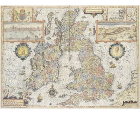
BRITISH ISLESSPEED (JOHN) The Kingdome of Great Britaine and Ireland, double-page hand-coloured engraved map, inset views of London and Edinburgh, decorated with putti, ships, compass and scale, Royal coat-of-arms, and sea monsters, English text on verso, 380 x 510mm., John Sudbury and George Humble, 1610 [or slightly later]This lot is subject to the following lot symbols: •• Zero rated for VAT, no VAT will be added to the Hammer Price or the Buyer's Premium.For further information on this lot please visit Bonhams.com

Lot 92
CANADASANSON (NICHOLAS) Le Canada, ou Nouvelle France, double-page engraved map, decorative cartouche, hand-coloured in outline, blank on verso [Burden 318], 400 x 545mm., Paris, Pierre Mariette, 1656Footnotes:An important map centered on the French possessions in Canada and its neighbouring colonies, and the first to include the five Great Lakes. 'This delineation would considerably influence the cartography of the region for over 100 years' (Burden).This lot is subject to the following lot symbols: •• Zero rated for VAT, no VAT will be added to the Hammer Price or the Buyer's Premium.For further information on this lot please visit Bonhams.com

Lot 93
EUROPESPEED (JOHN) Europ, and the Cheife Cities Contained Therein, double-page hand-coloured engraved map, borders with figures in national costume and city views, English text on verso, 590 x 510mm., George Humble, 1626; and 4 others, including a Speed map of Spain (5)This lot is subject to the following lot symbols: •• Zero rated for VAT, no VAT will be added to the Hammer Price or the Buyer's Premium.For further information on this lot please visit Bonhams.com
Lot 95
MORDEN (ROBERT) AND HERMAN MOLLFifty Six New and Accurate Maps of Great Britain, Ireland and Wales, 57 engraved maps hand-coloured in outline (numbered in ink on verso), short tear to map of Ireland, 7 maps slightly shaved within platemark at one edge, small light dampstain in fore-margins towards the end, a few short tears to title, this and first leaf of text cropped at foot, eighteenth century boards, worn, rebacked [Chubb CXXVI], oblong 4to (185 x 310mm.), John Nicholson, John Sprint, Andrew Bell, and Ralph Smith, 1708This lot is subject to the following lot symbols: •• Zero rated for VAT, no VAT will be added to the Hammer Price or the Buyer's Premium.For further information on this lot please visit Bonhams.com

Lot 97
WORLDMÜNSTER (SEBASTIAN) Altera generalis tab. secundum Ptol., woodcut map of Ptolemy's world, with 12 windheads amongst clouds in border, Latin text on verso, a few small worm trails in lower blank margin, sheet 315 x 395mm., [Basel, c.1545-50]This lot is subject to the following lot symbols: •• Zero rated for VAT, no VAT will be added to the Hammer Price or the Buyer's Premium.For further information on this lot please visit Bonhams.com

Lot 98
WORLDTEESDALE (HENRY, publisher) A New Chart of the World on Mercator's Projection, with the Tracks of the Most Celebrated & Recent Navigator, large hand-coloured map engraved by John Dower, divided into sections on 2 sheets and laid on linen, small loss to lower tip of Greenland, folding into original maroon morocco gilt portfolio, lettered in gilt on upper cover, worn, overall map size approximately 1292 x 1944mm., H. Teesdale, 1842Footnotes:Striking large wall map of the World, showing Texas as an independent state.This lot is subject to the following lot symbols: •• Zero rated for VAT, no VAT will be added to the Hammer Price or the Buyer's Premium.For further information on this lot please visit Bonhams.com


Lot 1188
Postcards, a mixed selection of 30 UK topographical cards and a few subjects, mostly RPs, inc. Bournemouth Aviation meeting, The Nene Northampton, Grately Hants (7), Replingham Rd., Tovil PO (faded), Groombridge, PO Goring Heath, Pangbourne village flood, Farringdon, Chester racecourse, Midland rail map etc. (mostly gd)

Lot 20
Stamps, mixed collection of GB and foreign stamps in albums, club books and loose. Includes covers with GB 2d blue and 1d reds imperf and mint, useable GB, also aviation covers inc. Imperial Airways Calcutta - London illustrated with map, Newfoundland inaugural illustrated flight cover Canada to USA June 1939, postal stationery etc (1 large box)

Lot 419
Cigarette cards, a collection of part-sets and odds from many different manufacturers and series with a good number of scarce issues included, Cohen Weenen, Cricketers (10), Salmon & Gluckstein, Coronation Series (3), Anstie, Scout Series, (9), Racing Series (23), Edwards Ringer & Bigg, War Map of the Western Front (8) etc, other issuers include Mitchell's, Lea, Hignett's, Cope's, Murray, Morris etc (very mixed condition, poor/vg) (100's)

Lot 715
Ephemera, all relating to Fountain Pens to include an advertisement for The Swan Pen with cycling map on verso, magazine advertisements for the Parker Duofold, Waterman's Fountain pens, John Bull, Macniven & Cameron, C. Brandauer & Co., Spencerian and William Mitchell's pens etc. (gen vg) (40+)
Lot 742
Ephemera, a large collection of assorted ephemera dating from the 19th and 20thC. An interesting mix of advertising, rail, Rebus puzzle, 1826 theatre poster for 'Douglas' and 'High Life Below Stairs', letter heads, 1982 Motor Show programme (with article re 'Ford's All New Sierra'), 1953 Coronation London Transport map, 1950s Christmas angel decoration and wrapping paper, playing cards, an embroidered 1953 Coronation linen cloth, printed letter from Downing Street dated October 1984 relating to the Brighton bombings, small collection of decorative cigar bands, photographs, book marks, Rupert Bear First Day Covers and Greetings stamps, a block of Rupert and Friends Guernsey stamps etc. Viewing recommended (gen gd) (large qty.)

Lot 743
Maps and Guide Books, mainly UK with some foreign, hardbacks and paperbacks to include Cook's Handbook To Venice (1923), Nelson's World Gazetteer (1930s), Bacon's Motoring And Cycling Map (1920s), guide books for Devon, Edinburgh, Glasgow etc., Bartholomew's and Smith's maps on cloth plus many others (fair/gd)

Lot 783
Railwayana, 10 x 1995 Metropolitan Railway large format printer's proof posters entitled 'Steam On', 2 x large format posters 'Happy Birthday Victoria', a London Transport Works and Buildings Dept. map, Syon Park White poster, Syon Park The London Transport Collection' poster and a 2000 Night Bus poster all 1990s (gen gd) (16)

Lot 791
Aviation, Air Display Programmes, Farnborough Air Show programmes from 1954, 1956 and 1957, S.B.A.C programmes for Flying Displays in 1952 and 1954, a 1958 programme for an R.A.F. Battle of Britain Week flying display, a B.E.A. 1950s Route Map for the UK and a 1953 set of Poster Stamps commemorating the Coronation in presentation folder (gen gd, some rs and signs of age) (8)

Lot 840
Topography, 45+ guide books and maps dating from the late 19th/early 20thC to include 11 Ward Lock and Co. guides (The Thames, The New Forrest, London etc.), 8 copies of 'The King's England' by Arthur Mee published by Hodder and Stoughton (Yorkshire West Riding, Lancashire, Sussex, Surrey etc.) 'The Handbook to The Rivers & Broads of Norfolk & Suffolk' circa 1890 complete with pull out map in rear pocket (mixed condition poor to gd) (45+)


Lot 338
CHURCHMAN, part sets & odds (some better), inc. Phil May Sketches (8), Pipes (13), Railway 1st & 2nd (17), Regimental Colours & Cap Badges (16), Rugby Internationals (12), Rivers & Broads, both (36), Sectional Cycling Map (22), Sporting Celebrities (3), Sporting Trophies (15), Sports & Games (22), Inns of Court (16), Wembley Exhibition (30) etc., in modern album, VG to EX, 300*


Lot 387
Quebec House and Portsmouth Harbour. Etching by Eggett, number 48 of 125 impressions, signed and inscribed in pencil, 14.6 x 21.5cm, together with a watercolour signed by B. Hansford Davies of Uplands Lodge, Fareham, plus a 19th century map of Hampshire, and two others prints after W.L. Wyllie and Joseph Simpson RBA, all glazed and framed (5)

Lot 388
View of the Town & Harbour of Portsmouth, 18th century engraving depicting the view from Gosport, 17 x 2.5cm, together with another 18th century engraving depicting the assassination of the Duke of Buckingham at Portsmouth c.1750, and two others including a hand-coloured map titled 'The Island of Portsea', all glazed and framed (4)

Lot 43
Smith (Chas.) The Ancient and Present State of the County and City of Cork, 2 vols. 8vo Cork 1815. New Edn., port. frontis. Vol. I, some fold. engd. plts. lack fold. map, cont. hf. calf; Gibson (Rev. C.B.) The History of the County and City of Cork, 2 vols. Lond. 1861. First Edn., map frontis Vol. I, list of subs., orig. cloth. Good. (4)
![[Harris] Ware: The Antiquities and History of Ireland, By the Rt. Hon. Sir James Ware, Knt., Folio L. 1705 First Edn. Thus.,](https://cdn.globalauctionplatform.com/0668ca5d-84f2-443e-be5f-ab6b01148104/140ce2f7-816d-4ac3-b68c-ab6b011e0515/468x382.jpg)

Lot 443
Co. Antrim: Dubourdieu (Rev. John) Statistical Survey of the County of Antrim, with Observations on the Means of Improvement; 8vo D. 1812. First Edn., lg. fold. engd. map, 5 fold. tables, 10 lg. fold. sepia plts., 8 sepia single page plts., & a sepia vignette, cont. hf. calf. V. good copy. (1)
![Travel: Head (Sir F.B.) A Fortnight in Ireland, L. 1852. First, fold. map, hf. mor.; [Gough (J.)] A Tour in Ireland, in 1813](https://cdn.globalauctionplatform.com/0668ca5d-84f2-443e-be5f-ab6b01148104/7921b7bb-0d95-49b4-80c9-ab6b011da492/468x382.jpg)


-
109182 item(s)/page