We found 109182 price guide item(s) matching your search
There are 109182 lots that match your search criteria. Subscribe now to get instant access to the full price guide service.
Click here to subscribe- List
- Grid
-
109182 item(s)/page


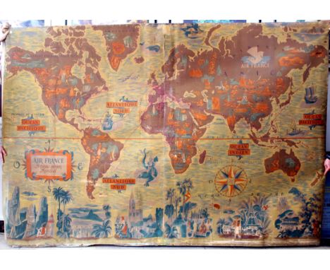
Lot 15
Original vintage planisphere travel advertising poster featuring a detailed illustrated Air France worldwide airline network map / Air France Reseau Aerien Mondial designed by the notable artist Lucien Boucher (1889-1971) showing the airline routes across the world decorated with sea gods, sailing ships, cruise liners and planes with landscape features and mountains, buildings, animals and people from around the world on the continents, the main cities and countries marked in banners with colourful compass points and cherubs blowing in wind on each side, the title text in a banner below and the Air France Pegasus logo above. Horizontal. Printed in France by Perceval, Paris. Fair condition, restored loss on margin, folds and tears, staining, backed on linen. Country: France, 1937, design by Lucien Boucher, size (cm): 64x100.5
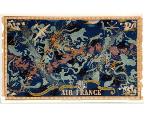
Lot 20
Air France Night Sky Constellation poster. Lucien Boucher produced a number of pieces for Air France in the early 20th century which were advertisments for the global coverage and glamour of air travel at the time. This version, from 1938, combines a subtle outline map with key places with a celestial planisphere that shows the various signs of the zodiac. The suggestion is of fantasy and the experience you’ll have flying. It’s designed clearly to capture the imagination and provide a strong brand message.Original vintage travel poster. Poor condition, minor creases, tears and paper losses. Backed on foam board. Country: France Year: 1938 Designer: Lucien Boucher Size: 99x62cm

Lot 2103
Original vintage railway poster showing a map of The Clyde and West Highlands with tourist routes highlighted. The North British Railway was a British railway company, based in Edinburgh, Scotland. It was established in 1844, with the intention of linking with English railways at Berwick. The line opened in 1846, and from the outset the Company followed a policy of expanding its geographical area, and competing with the Caledonian Railway in particular. In doing so it committed huge sums of money, and in doing so incurred shareholder disapproval that resulted in two chairmen leaving the company. Nonetheless the Company successfully reached Carlisle, where it later made a partnership with the Midland Railway. It also linked from Edinburgh to Perth and Dundee, but for many years the journey involved a ferry crossing of the Forth and the Tay. Eventually the North British built the Tay Bridge, but the structure collapsed as a train was crossing in high wind. The company survived the setback and opened a second Tay Bridge, followed soon by the Forth Bridge, which together transformed the railway network north of Edinburgh. Early on, mineral traffic became dominant and brought in much more revenue than the passenger services. At the grouping of the railways in 1923, the North British Railway was the largest railway company in Scotland, and the fifth largest in the United Kingdom. In that year it was a constituent of the new London and North Eastern Railway. Fair condition, creasing, foxing, staining and restored tears. Right Margin is damaged with several paper losses and small tears. Country: UK Year:1910s Designer: Unknown Size: 101x83

Lot 2203
Original vintage colour railway map of the Great Western Railway, includes details, to larger scale, of the system in London & suburbs, South Wales, and Birmingham & district. The Great Western Railway (GWR) was a British railway company that linked London with the south-west and west of England, the Midlands, and most of Wales. It was founded in 1833, received its enabling Act of Parliament on 31 August 1835 and ran its first trains in 1838. It was engineered by Isambard Kingdom Brunel, who chose a broad gauge of 7 ft (2,134 mm)?later slightly widened to 7 ft 1?4 in (2,140 mm)?but, from 1854, a series of amalgamations saw it also operate 4 ft 8 1?2 in (1,435 mm) standard-gauge trains; the last broad-gauge services were operated in 1892. The GWR was the only company to keep its identity through the Railways Act 1921, which amalgamated it with the remaining independent railways within its territory, and it was finally merged at the end of 1947 when it was nationalised and became the Western Region of British Railways. Printed by Emery Walker Ltd. Horizontal. Very good condition, original folds. Country: UK Year: 1920s. Designer: Unknown Size:65x50.5cm

Lot 49
Rare large original vintage planisphere poster map of Air France routes issued only to Air France offices. The poster features a detailed illustrated Air France worldwide airline network map / Air France Reseau Aerien Mondial designed by the notable artist Lucien Boucher (1889-1971) showing the airline routes across the world decorated with sea gods, sailing ships, cruise liners and planes with landscape features and mountains, buildings, pictures of animals and people from around the world on the margins and on the map, and the Air France Pegasus logo above. Poor condition, trimmed on all sides, losses, tears and cuts, backed on old linen, France, 1950s, size (cm): 305x204.

Lot 50
Sabena - All the Skies of Europe Original vintage travel advertising poster in French: Sabena - to all the skies of Europe, Belgian Air Lines. Image of a four propeller plane above an outline map of Europe marking Sabena's destinations. Sabena was the national carrier of Belgium from 1923-2001. Art by C Pub Dohet. Printed by O de Rycker SA Brussels. Good condition, light staining on top and left margin. Advertising Poster, Belgium, 1950, design by Dohet, size (cm)99.5x64.5.

Lot 61
Original vintage travel advertising poster published by Cie Generale de Transports Aeriens CGTA Air Algerie / Air Algeria featuring a great design by the French artist Albert Brenet (1903-2005) depicting an Air Algeria propeller plane above a airport runway with a map of France in the background marking the cities served by the airline company: Paris, Marseille, Nice, Perpignan, Toulouse, Lyon, Clermont-Ferrand and Geneva with the title text below. Printed in France by Photolith, Paris. Very good condition, creases. Country: France, 1950s, design by Albert Brenet, size (cm): 57.5x40
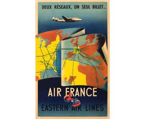
Lot 71
Original vintage travel advertising poster: Two networks, one ticket only... Air France - Eastern Air Lines / Deux reseaux, un seul billet... Colourful design featuring a wavy map of the world showing the flight connections served by Air France and Eastern Air Lines between North America - Europe - North Africa with a plane flying above against the dark blue background with the text and the Air France pegasus logo and Eastern Air Lines eagle logo intertwined below with the red, white and blue tricolour French flag and the stars and stripes American flag. Eastern Air Lines (1926-1991) was an American airline headquartered in Miami. Air France (founded 1933) is the national French flag carrier headquartered in Tremblay-en-France. Printed in France by Hubert Baille & Cie., Paris. Very good condition, restored minor loss, pinholes and minor tears on margins, backed on linen.. Country: France, 1950, design by Renluc, size (cm): 50x31.5


Lot 39
Betts, John, Betts's , George Philip & Son, London, n.d, circa 1860, game map of the counties, tracing a course through 91 points, diagram of the relative heights of mountains in England and Wales compared to St Paul's Cathedral, engraved and hand tinted, dissected and linen backed, folding into cloth boards, the latter bearing the Ex Libris / bookplate of Major-General Sir John Ponsonby KCB CMG DSO (1866-1952) 'John Ponsonby / Coldstream Guards'


Lot 1043
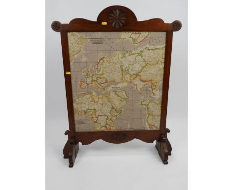
A tray of interesting items including oriental jewel cabinet, hallmarked silver decorated bible, cased pipe, sewing kit, pearls (simulated), cutlery with some silver handled pieces noted, spelter unusual figure, interesting cloth, folding map of Worcester, souvenir of Malta, photographs, purses, miliatry hat etc.


Lot 266
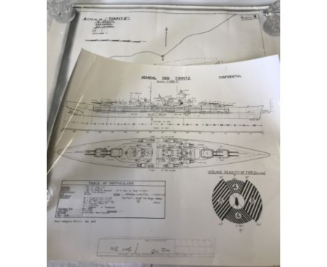
A large quantity of Great War period documents largely pertaining to the 2nd Oxfordshire and Buckinghamshire Light Infantry, including typewritten Nominal Rolls, Prisoner of War rolls and tallies, autograph manuscript letters, trench maps, Map of the Main Prison Camps in Germany with annotations, Regimental Orders, 1914 Star medal roll etc


Lot 386
I SCHAPERA "The Bantu-Speaking Tribes of South Africa, An Ethnographical Survey" 1st edn., 1937, published by George Routledge & Sons, Ltd., London/Maskew Miller, Ltd., Cape Town, inc. folding maps; and one other, Hollis "The Masai, Their Language and Folklore", 1905, lacks map and one plate, (2).


-
109182 item(s)/page