We found 108737 price guide item(s) matching your search
There are 108737 lots that match your search criteria. Subscribe now to get instant access to the full price guide service.
Click here to subscribe- List
- Grid
-
108737 item(s)/page


Lot 501A
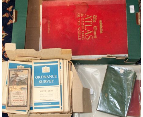
six maps of various counties and dates plus pictures of mountainous scenery: One map of Cheshire showing parishes and Parliamentary divisions in 1971, size 1050x800mm One map of Wiltshire published by Chapman and Hall 1832 size 250x190mm One map of Hartfordshire, half sheet county map by Emanuel Bowen circa 1760, original hand colour size 330x230mm one map of Northumberland by Robert Morden 1965 and later, uncoloured, size 420x350mm One map Lancashire facsimile of Speed's 1611 map Portraits of Kings & Queens incl Richard III, fine art society 1906, size 510x380mm One map England & Wales divided into Counties, published circa 1760 by Thomas Kitchin, uncoloured, some repair, Size 490x410mm 13 pictures of Mountainous scenes (Q)

Lot 502A
Five County maps of Gloucestershire, various dates and publishers: One map by Badeslade Toms dated 1742, uncoloured , size 150x140mm One map by Sidney Hall, dated 1830, uncoloured size 245x190mm One map by HG Collins circa 1850, coloured as printed, size 420x350mm One map from Pictoral World Atlas circa 1870, description of County verso, coloured, size 415x350mm One map by Greenwood and Co, published 1831, coloured as printed. Vignette of Gloucester Cathedral by Creighton, size 680x600mm (5)


![PHILLIPS, J[ohn] & HUTCHINGS, W. F., A Map of the County of Stafford Divided into Hundreds & Parishes, From an Accura](https://cdn.globalauctionplatform.com/c3317d75-dc89-4a67-a453-a42f0098d4e6/ee2b05da-a373-4264-9a2c-8c139fe4655d/468x382.jpg)
Lot 100
PHILLIPS, J[ohn] & HUTCHINGS, W. F., A Map of the County of Stafford Divided into Hundreds & Parishes, From an Accurate Survey, Made in the Years 1831 & 1832, By J. Phillips & W. J. Hutchings, London, published by Henry Teesdale & Co. 302, High Holborn, London, August 1st, 1832, 137 x 100cm.; 54 x 39.5in.

Lot 95
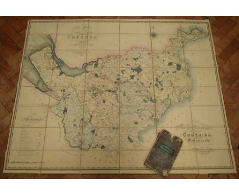
Cheshire. Bryant (A.) Map of the County Palatine of Chester, from an actual survey in the years 1829, 1830 and 1831, large map in 2 horizontal sections, the upper sheet with decorative title, upper centre, the lower sheet with a vignette view of Chester Cathedral, lower right, engraved map with bright original hand-colouring, in 2 sections, overall 151.5 x 191.5cm.; 59.75 x 75.5in. dissected and mounted on linen, edged in green silk, some offsetting of text and vignette, folds into original green morocco endpapers, housed within gilt-lettered morocco pull-off case.

Lot 98
LIVERPOOL, BENNISON (JONATHAN) A Map of the Town and Port of Liverpool, large engraved map by J. Dower after Bennison, finely hand-coloured, dissected and laid on linen, folding into publisher's maroon morocco slipcase, rubbed, overall 130.5 x 180.5cm.; 51.25 x 71in, Liverpool, J. Bennison, 1835.


Lot 308L
ATLAS. MAPS OF THE SOCIETY FOR THE DIFFUSION OF USEFUL KNOWLEDGE, HAND COLOURED ENGRAVINGS INCLUDING THE GEOLOGICAL MAP OF ENGLAND AND WALES, FOREIGN COUNTRIES AND TOWN PLANS BOUND WITH THE INDEX TO THE PRINCIPAL PLACES IN THE WORLD (MODERN)...BY THE REV JAMES MICKLEBURGH, RECENT BROWN CLOTH, 1844, EX LIBRIS

Lot 808
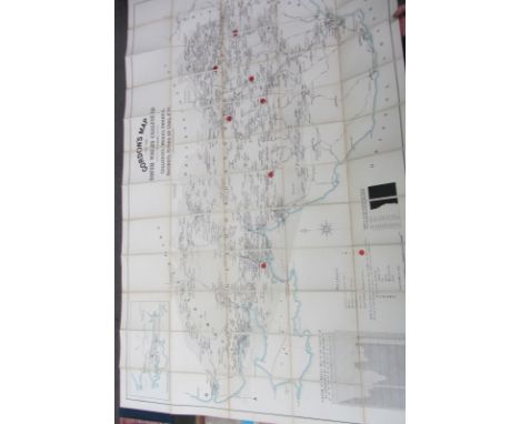
COALFIELD MAP - Gordon's Map of the South Wales Coalfield: shewing collieries, works, owners, railways, kinds of coal, etc. folded & mounted on linen, opens to 106 x 168 cms., part colour, scale: 1 inch to mile, reference key & 3 diagrammatic tables (incl. wages paid & annual output), inset map of the western extension across Carmarthen Bay; in the original gilt-lettered cloth case; (? Swansea, G.E. Gordon), 1913. * most detailed, with very many industrial undertakings (of all kinds) being named.
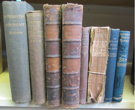
Lot 868
JOHNSTON (G.) An Introduction to Conchology . . . text engravings, errata leaf; gilt-lettered cloth. 1850; REEVE (L.) The Land and Freshwater Mollusks indigenous to, or naturalized in, the British Isles. engraved portrait frontis., coloured & folded map, text engravings; gilt-pictorial cloth. 1863; with a few other related books (8)
Lot 875
DIXON (F.) The Geology of Sussex . . . new edition, revised and augmented by T. Rupert Jones. 64 lithographed plates (3 coloured & 2 d-page), diagrammatic plate, a coloured & folded map, engraved text illus.; old binder's cloth, thk. 4to. Brighton: William J. Smith, 1878. * included in this edition were 'a selection of the original quarto plates of Mantell's "Fossils of the South Downs" . . . (1822)'
Lot 892
DUGDALE (W.M.) The Antiquities of Warwickshire, illustrated from Records, Leiger Books, Manuscripts, Charters . . . (new edition). engraved plates and maps (some folded) & num. text engravings the Knight Low maps torn with some loss, appears to lack Beighton's Hemimgfold Hundred map), old calf defective), folio. Coventry; re-printed by John Jones, 1765 * 'this Edition is carefully Copied, without the least alteration from the Old One, published in the year 1656 . . .'; appears complete (save as mentioned), but sold as found.
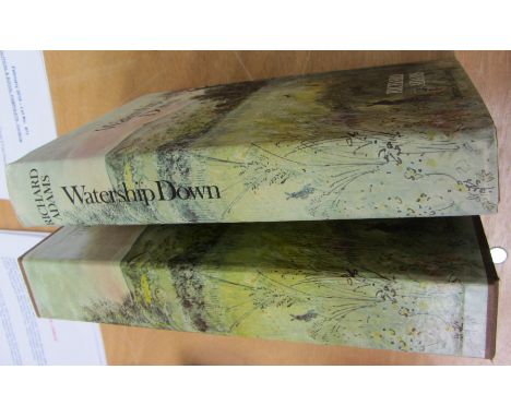
Lot 931
ADAMS (R.) Watership Down. Illustrated Edition. full-page colour illus., other text illus. & text decorations (by John Lawrence), coloured & folded map; cloth-backed boards in d/wrapper & in matching slipcase, roy. 8vo. Penguin/Kestrel Books, 1976. * the first printing of this edition; Elizabeth Beresford's copy (author of 'The Wombles') & loosely inserted (& relating to the book's 1st edition, 1973) is the publisher's compliment slip & an eleven line tls. (1st May 1973) from the Puffin Books editor, Jacqueline Graham, concerning the cover (by Pauline Baynes) of the Puffin edition, with relevant notes by the recipient covering the sheet's blank spaces.


Lot 969
Thomas POWNALL - A NEW MAP of NORTH AMERICA, with the WEST INDIA ISLANDS. Divided . . . (into the United States, and the Several Provinces, Governments &c.) which compose the British Dominions . . . hand-coloured & varnished, 104 x 119 cms., pictorially decorated cartouche title, decorated scale cartouche, insets of Baffin and Hudson's Bay, also California. Laurie & Whittle, 1794.

Lot 975
MOLL (Herman) A New and Exact Map of the Dominions of the King of Great Britain on ye Continent of North America. Containing Newfoundland, New Scotland, New England, New York, New Jersey, Pensilvania, Maryland, Virginia and Carolina . . . hand-coloured, 100 x 60 cms. within mount; headed title, central arms & dedicatory cartouche, in lower part insets of Gulf of Mexico, Carolina, Plan of Charleston, overall map of N. America & the famous illustration of beavers 'logging' at Niagra Falls. 1715. * important map in a handsome triple gilt frame; appears to be in 3rd-5th state

Lot 980
James CLARKE. A Map of the Roads &c. between Keswick and Broadwater. hand-coloured, 58 x 82 cms. within mount; scale: 10ins. to mile (approx.) * being plate 7 from 'A Surrey of the Lakes of Cumberland, Westmorland and Lancashire' (1787); decorative title; very detailed with named houses (some owners), turnpike gates (etc.) named; individual fields delineated.


Lot 983
PHILIP LEA - A New Map of England and Wales. With the direct and cros (sic) roads . . . hand-coloured, 2 sheets (only, ex 4?), each 14 x 48 cms. within the ruled borders, decorated scale bars, engraved cartouche title. sold by Phillip Lea . . . at the Atlas and Hercules . . . (1687?). * the map's two lower sheets - the South & West Coasts to Owestry/Nottingham/Cromer


Lot 59
A collection of 19th century and other ceramics including a set of six early 19th century tea bowl of wrythen moulded form with pink, grey and yellow trailing leaf and floral border decoration, with painted numbers to base 183 together with four matching saucers and a matching cream jug, a 19th century coffee can with painted decoration on a blue and gilt ground, a match strike/pipe stand with printed map showing the Environs of Liverpool, with printed mark to reverse for MacIntyre & Co, two Prattware pot lids, a small collection of miniature German tea wares with painted rose decoration including teapot, covered sugar bowl, etc and a 19th century continental stand with painted and encrusted floral decoration, etc


Lot 434
Gerardus Mercator (1512-1594) - Coloured engraved map - "Scotia Regnum", 13.75ins x 15.825ins, in gilt frame and glazed Note : The original map plates were bought in 1604 by Jodocus Hondius who published enlarged editions of this and other works by Mercator. This example was probably published in Amsterdam circa 1630


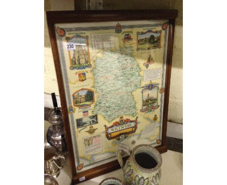
Lot 230
A framed and glazed map of Wiltshire, commissioned for the Wiltshire Regiment in contemporary frame by David Joel Limited, Kingston Bypass, London, the map by permission of the Rt. Hon. R. S. Hudson, C. H. M. P. Minister of Agriculture and Fisheries, 1940 - 45, designed and drawn by Ernest Clegg and printed by Waddington 1946.


Lot 133
An interesting collection of German and British World War Two (WWII) ephemera to include Strassenkarte von Deutschland 1940 (map), The Far East (map), Order of Service, end of war Thanksgiving, 6th Airborne Division held in the Nikolaikirche at Wismar May 6th 1945, Führergeschenk für Fronturlauber German ration cards) and other papers


-
108737 item(s)/page