We found 109182 price guide item(s) matching your search

Refine your search

Year

Filter by Price Range
  • List
  • Grid
  • 109182 item(s)
    /page

Lot 361

John Senex (fl. 1702-1740)'A New Map of Ireland ...'. From A New General Atlas 1721. 670 x 950. Abl 65.

Lot 362

John Senex (fl.1702-1740)A Map of IrelandFrom his New General Atlas of the World. 488 x 581. Abl 65(i).

Lot 364

Herman Moll (1655-1732)A Map of IrelandFrom his Atlas Minor published by Thomas & John Bowles (1740). 280 x 300. Abl 67(v).

Lot 367

Tobias Conrad Lotter (1712-1797)A Map of IrelandRegnum HiberniæLotter's rescue of Seuter's map. 493 x 577. Abl 72(iii).

Lot 368

Emanuel Bowen (1694-1767)A new and accurate Map of Ireland(C.1765). 225 x 325. Abl 74(iii).

Lot 371

Richard William Seale (1732-1785)A Map of the Kingdom of IrelandFrom Tindal's continuation of Rapin's History of England (1744) 395 x 495; together with plans of the Sixteen Principle Towns in Ireland. 495 x 405. Abl 76. (2)

Lot 373

George Bickham (1684-1758)A Map of IrelandFrom his British Monarchy published in London in 1754. 140 x 230. Abl 79.

Lot 375

Giles Robert de Vaugondy (1668-1766)Le Royaume D'Irlande From de Vaugondy's Altas Universelle, 1752. Note first states of this map are uncommon. 555 x 495. Abl 83(i); together with the title page of the atlas. (2)

Lot 379

Leonhard Euler (1707-1783)A Map of IrelandFrom his Mappa Geographica, published in Berlin, 1753-60. 325 x 389. Abl 83(iii).

Lot 382

Thomas Jefferys (1719-1771)'A New and Accurate Map of Ireland'From issued separately or used in composite atlases. 595 x 650. Abl 91(iii).

Lot 383

John Rocque (1709-1762)'A Map of the Kingdom ...' in four sheets (two sheets joined), with Laurie & Whittle's imprint. From various atlases (1794-1801). 967 x 1250. Abl 93(iii). (2)

Lot 384

John Rocque (c.1719-1771)'A Map of the Kingdom ...' In four sheets (two sheets joined) with Sayer's imprint. From various atlases. (1773-1795). 967 x 1,250. Abl 93(ii).

Lot 385

Robert du Vaugondy (1723-1786)L'Irlande ...Four states of the same map from various editions of the Nouvel Atlas Portatif by Du Vaugondy. Abl (i), (ii), (iv) and (v). (4)

Lot 386

John Bayly (1763)A New Map of the Kingdom of Ireland ...From The Large English Atlas, 1764. 484 x 551. Abl 97(ii).

Lot 391

Jean Palairet (1697-1774)A Map of IrelandFrom An Elementary and Methodical Atlas, 1775. 525 x 437. Abl 111.

Lot 392

Thomas Kitchin (1718-1784)A New Map of IrelandFrom the Large English Atlas, 1777. 650 x 565. Abl 114(i).

Lot 394

Didier Robert de Vaugondy / P. SantiniA Map of IrelandLe Royaume D'Irlande From an Italian Atlas Universelle. Published in Venice in 1784. 540 x 475. Abl 116(ii).

Lot 396

Antonio ZattaA Map of Ulster and Leinster and a Map of Connaught and MunsterFrom his Atlante Novissimo. Venice (1779). 315 x 410. Abl 119 (a & b). (2)

Lot 397

Henry Carrington BowlesBowles' New Pocket Map ...1791From Bowels' New Pocket Map... 1791. 580 x 624. Abl 120(ii).

Lot 398

Henry Carrington BowlesBowles' New Pocket Map, 1791. From Bowles' Universal Atlas n.d. 580 x 624. Abl 120(iii).

Lot 401

Pierre Francois Tardieu (1752-1798)Two States of the Map of IrelandFrom various Montelle atlases. 350 x 335. Abl 128(i) & (ii). (2)

Lot 402

William WilsonWilsons new and accurate Map...From the Post Chaise Comapnion (1783). 340 x 440. Abl 132(ii); and a Plan of the City of Dublin from Wilson's Dublin Directory of 1794. 385 x 295. Abl D 31. (2)

Lot 405

John Haywood (1784-1815)'A New Map of Ireland'1787. 356 x 414. Abl 135.

Lot 406

John RussellA Map of IrelandC.1802. 370 x 405. Abl 136(iv).

Lot 407

Franz Anton Schnaemble (1751-1804)A Map of IrelandKart von IrelandFrom his Grand Atlas Universel (1790). 565 x 635. Abl 137.

Lot 408

John CaryA Map of Ireland Divided ...From Gough's edition of Camden's Britannia, 1789. 418 x 510. Abl 140(i).

Lot 409

John CaryA New Map of Ireland Divided ...From Gough's edition of Camden's Britannia, 1806. 418 x 510. Abl 140(i).

Lot 410

Franz Joseph von Reilly (1766-1820)A Map of Ireland and a Map of Ireland North and South Chauplatez der ... . Published Vienna, 1789. 210 x 280 (2) and 275 x 215. Abl 142. (3)

Lot 411

The Rev. D. Beaufort A New Map of IrelandIn two sheets. Second edition. Normally issued and sold as a separate map. 878 x 554 and 878 x 528. Abl 146(iii). (2)

Lot 412

Alexander TaylorA New Map of IrelandIssued separately. 1793. 594 x 715cm. Abl 150(i).

Lot 413

Franz Joseph von ReillyA Map of IrelandKarte von IrelandFrom Glosser Deutscher Atlas (1796). 635 x 480. Abl 160.

Lot 415

William Faden (1750-1836)A Map of IrelandFrom A General Atlas ... . 1798. 537 x 701. Abl 166(i).

Lot 416

John CaryA New Map of Ireland Divided ...From Gogh's edition of Camden's Britannia, 1799. 521 x 460. Abl 140(i).

Lot 417

John CaryA New Map of Ireland Divided ...From Cary's New Universal Atlas, 1811. 521 x 460. Abl 174(ii).

Lot 418

John CaryA New Map of Ireland Divided ...From Cary's New Universal Atlas, 1819. 521 x 460. Abl 174(iii).

Lot 419

John CaryA New Map of IrelandFrom Cary's New Universal Atlas. 1824. Issued as a seperate map. Abl 174(iv).

Lot 423

Joseph Enouy'A New Map of Ireland'From A New and Elegant Atlas published by Laurie & Whittle. 1802. 505 x 250. Abl 186(i).

Lot 424

Joseph Enouy'A New Map of Ireland'From A New and Elegant Atlas published by Laurie & Whittle 1808. With the addition of a new edition considerably improved within the title and extra lines added to the descriptions at the bottom. 505 x 250. Abl 186(iii).

Lot 427

William AllenAllen's New and Correct Pocket Map ...Engraved by John Taylor, Donnybrook. (1815). For the Traveller's New Guide Through Ireland. Published Dublin, 1818. 275 x 205. Abl 212(ii).

Lot 428

ArrowsmithIrelandIn two sections, North and South, each two sheets which when joined together produce a large map of Ireland in four sheets. 1811. A separate publication. Abl 221(i). (2) 207 x 257

Lot 431

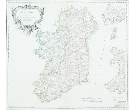
Samuel & George NeeleIreland, in two sheets, North & SouthFrom Neele's General Atlas, 1813. 281 x 223. Abl 239(i).Anon.A New Map of Ireland from ...Engraved by Prinald for A New Geographical Directory, 1760. 190 x 279. Abl 92(i).Georges Louis Le RougeL'Irlande From Atlas Noveau Portalit, 1748. Four sheets. 206 x 285. Abl 80.

Lot 433

John Hewitt Thompson (1813-1869)A Map of Ireland in two parts, North and South502 x 593. Abl 249. (2)

Lot 435

John CaryCary's New Map of Ireland ...From Cary's New Universal Atlas, 1824. Issued seperately 763 x 620. Abl 174(iv).

Lot 436

Sheffield GraceA Map of IrelandBy Sheffield Grace, 1825. 185 x 215. Abl 290.

Lot 438

John EmslieGeological Map of Ireland. Published by Reynolds, 1860. 220 x 280.Thomas StarlingIreland. From The Royal Cabinet Atlas. Published by Bull, London, 1834. 89 x 143. Abl 311(ii).John CaryA New Map of Ireland. Published by MacGowen & Davis, 1781. 183 x 223. Abl 125(i).A New Map of Ireland from The Field of Mars. Published London, 1801. 183 x 223. Abl 125(ii). (4)

Lot 441

Henry TeesdaleIreland (with the railway added)From Teesdale's A New Grand Atlas of the World, 1848. 336 x 417. Abl 317(v).Military MagazineMaps of the Counties of Mayo, Sligo etc.From The Military Magazine, published October 1788. 311 x 263. Royal MagazineA Map of the Province of UlsterEngraved by Rolles for The Royal Magazine. 175 x 100. (3)

Lot 442

James PigotA Map of Ireland'Pigot & Co. Map of Ireland'. From Pigot & Co.'s British Atlas (1840). 525 x 675. Abl 326(ii).

Lot 443

Isaac Slater (1829-1878)Slater's (late Pigot & Co.) 'New Map of ... ' from Slater's New British Atlas. 525 x 675. Abl 326(iii).

Lot 444

The Society of the Diffusion of Useful KnowledgeThree Maps of IrelandTwo editions of the single sheet map and one copy of the two sheet map. Abl 346. (3)

Lot 446

Flemming, Carl (1815-1879)A Map of IrelandFrom Universal Hand-Atlas (1844). 299 x 368. Abl 377.

Lot 447

AnonFour Maps of Ireland(i) 'Ireland', John Dower from Milner's Descriptive Atlas (1850)Abl 303(v); (ii) 'Ireland' from John Lothian's The People's Atlas (1896), Abl 391; (iii) 'A New Map of Ireland ...', Anon From Cooke's Modern and Authentic ... Geography (1803), Abl SG 56(i); and (iv) another engraved by C. Clark. (4)

Lot 449

William Home Lizars (1788-1859)A Map of IrelandFrom his General Atlas (1853). 220 x 250.

Lot 451

G. RollosA Map of UlsterFrom The Royal Magazine. 175 x 105.

Lot 452

John Tallis(i) A Map of Ireland. 240 x 345cm; (ii) A Town Plan of Belfast. 245 x 345. (iii) A Town Plan of Cork. 345 x 270. (C.1851). (3)

Lot 457

William Faden (1749-1836)A Plan of the City of DublinFrom Malton's Picturesque Views of Dublin. First edition, 1797. This map is normally found in early editions of Malton's book 1797. Abl G 31.

Lot 458

AnonA New and Accurate Map of the Kingdom .... From The Universal Magazine, 1799. 275 x 315. Abl 56 48.IrelandFrom the later editions of Salmon's A New Geographical and Historical Grammar, 1862-72.Abl SG 1(ii)A New and Correct Map of ...Engraved by Paas in Russell's New Historical and Commercial History of Geography, 1800-1815. Abl SG 51.

Lot 46

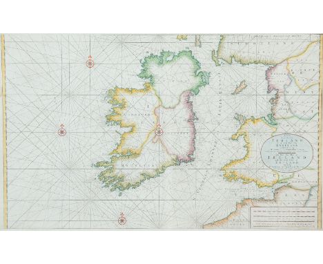
Johannes van Keulen (c. 1654-1715)Chart of Ireland and the Irish Sea Koeman No. 298. It occurs first in van Keulen's Zee-Atlas of 1718 and then in De Nieuwe Groote Lichtende Zee-Fakkel of 1734 and in some subsequent editions.The chart shows all of Ireland and the coast of Great Britain from Land's End to Ayr. In Ireland the Ards peninsula, Island Magee, the tip of Innishowen and Mullet are all shown as islands. The title, in a plain oval frame over Wales, reads Nieuwe Paskaart van Ierland en de West kust van Engeland Vervattende in sig St. Joris en het Verkeerde Kanaal, Gelegt naer de Nieuwste ondervinding van ervaren Zeelieden. The New sea Map of Ireland and the West Coast of England containing St. George and the Channel of Bristol made according the newest experience of Expert Mariners. The publisher's imprint is in a rectangular frame with scroll-like ends, in the top right corner, and reads te Amsterdam by Joannes Van Keulen Boek en Zeekaart verkooper aan de Nieuwen Brug met Privilegie. The scales are in the lower right corner reading Duytsche Mylen van 15 in een Graad 25 [= 184 mm.] Fransche Mylen van 20 in een Graad 33 1/3 [= 184 mm.] Engelsche Mylem van 60 in een Graad 100 [= 184 mm.] Schotse Mylen van 50 in een Graad 40 [= 91 mm.] Ierse Mylen van 48 in een Graad 40 [= 91 mm.]. There are soundings scattered round all the coasts as well as four compass roses showing north at the top and scales of latitude on either side of the chart. (977 x 595 mm.).

Lot 461

Matthew Wren (fl.1761-68)A Map of the County of LouthIn four sheets. 430 x 595.

Lot 462

George Taylor and Andrew SkinnerA Map of the County of Louth in Four PartsFrom The Grand Jury Map of the County. Engraved by Garrett & Terry, London (1777). 520 x 675 each.

Lot 463

Alexander TaylorA Map of the County of KildareIn six sheets. From The Grand Jury Map of the County. 1783. 780 x 590 (each).

Loading...Loading...
  • 109182 item(s)
    /page

Recently Viewed Lots