We found 109182 price guide item(s) matching your search
There are 109182 lots that match your search criteria. Subscribe now to get instant access to the full price guide service.
Click here to subscribe- List
- Grid
-
109182 item(s)/page


Lot 2001
'A Memoir of The Yorkshire Esk Fishery Association' by Thomas H. English, pub. Forth & Son, Whitby 1925b/w illust, cloth gilt and 'Yorkshire Rivers, No.8, The Esk' by Tom Bradley pub. Leeds c1900, with map, 2vols. Provenance: Property of a Private Whitby Collector. Condition Report Click here for further images, condition, auction times & delivery costs

Lot 2027
The Dunsley Estate Auction Sale Catalogue, 26th September 1944, with map, Memorandum & Articles of Association of Staithes Fishing Co.Ltd, 1916, similar Whitby Empire Electric Theatre Ltd. 1914International Fine Steamship Co.Ltd. Balance sheet 1890 & Whitby UDC Report on Post-War Development & Planning 1945, (5) Provenance: Property of a Private Whitby Collector. Condition Report Click here for further images, condition, auction times & delivery costs

Lot 2040
Victorian Whitby Property Auction Particulars for Valuable Building Ground on and contiguous to the West Cliff on 28th April 1857, and a Victorian Whitby Town Boundary Report with map, 28cm x 43cm max (2). Provenance: Property of a Private Whitby Collector. Condition Report Click here for further images, condition, auction times & delivery costs

Lot 2050
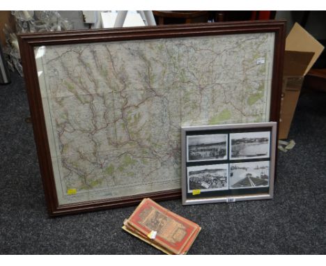
'The Environs of Whitby and Robin Hood's Bay' map with some colouring, Third Edition pub. W. Faden, Charing Cross, May 1st 1800, 63cm x 74cm & an OS map Sheet XXXll N.W. Raithwaite and Sandsend, both unframed (2). Provenance: Property of a Private Whitby Collector. Condition Report Click here for further images, condition, auction times & delivery costs

Lot 2063
'A History of Whitby, and Streoneshalh Abbey, with a Statistical Survey of the Vicinity' to the Distance of Twenty-five miles, by The Rev. George Young, vols 1 and 2, pub Whitby 1817, with linen backed fold out map and folld out and other plates, half calf with marbled boards 2vols Condition Report Vol 1 lacks spine & boards detached Click here for further images, condition, auction times & delivery costs

Lot 2064
'A History of Whitby, and Streoneshalh Abbey, with a Statistical Survey of the Vicinity' to the Distance of Twenty-five miles, by The Rev. George Young, vols 1 and 2, pub Whitby 1817, with fold out map and plates, rebound half calf with marbled boards 2vols Condition Report Click here for further images, condition, auction times & delivery costs

Lot 2065
'The History of Whitby and of Whitby Abbey' by Lionel Charlton Teacher of the Mathematics at Whitby, pub. A. Ward 1779 with three plates, folding map, with The True Account of the Murder of the Monk of Whitby and two Descriptions of Whitby Abbey Monumental Inscriptions, inserted at back, half calf Condition Report Click here for further images, condition, auction times & delivery costs


Lot 2077
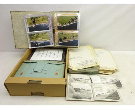
Three North Region 1" cloth-backed folding maps, North of Wooler to South of Sheffield, similar NW map, collection of c1999 Coastal Aerial Photographs of the NE Coast, and a qty of scale drawings of The Calder Valley Flood Prevention Scheme, etc Condition Report Click here for further images, condition, auction times & delivery costs


Lot 2085
Bulmer's History Topography and Directory of North Yorkshire, 1857, and 1890 with fold out map, Kelly's Directory of the North & East Ridings of Yorkshire, 1933, wth two fold out maps, red cloth, 3vols Condition Report 1857 not complete, begins at p83 Click here for further images, condition, auction times & delivery costs


Lot 2378
Collection of Post Card mostly post 1900, including RP Horse & Cart Leytonstone, Chromo. Ristorante advert. photos. of 33 Flight in Lecce with Menu. map of Liccata, Schizzo Panoramico map, other photos and Souvenir cards, in album Condition Report Click here for further images, condition, auction times & delivery costs


Lot 2439A
'Wallis's Tour of Europe, A New Geographical Pastime', folding linen backed game with directions, pub London 1794, another without directions, pub 1811, and 'An Epitome of Geography, designed as a Companion to a Geographical Game invented by the Abbe Gaultier, pub 1831 (3) Condition Report 1794 map tape repaired Click here for further images, condition, auction times & delivery costs


Lot 2443
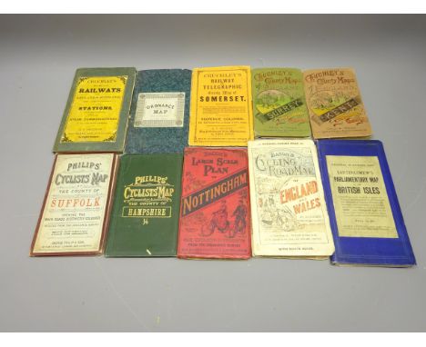
Cruchley's County Maps of England, Surrey & Kent, Railway's of England & Scotland, Railway and Telegraphic County Map of Somerset, Reduced Ordnance Map No.34, Phillips' Cyclists Maps of Suffolk & Hampshire, Bacon's similar GB & Nottingham, Bartholomew's Parliametary Map of the British Isles for the General Election of 1880 Condition Report Click here for further images, condition, auction times & delivery costs

Lot 2444
'Via Northern' Great Northern Telegraph Co. Map of the Companies Cables and Connecting Landlines' linen backed folding map with red cloth boards, 'A New Map of Derbyshire', by John Carey 1811, in slip case, Smith's Map of England & Wales' printed for C. Smith 1825, Wallis's, Picturesque Round Game of the Produce of England & Wales, c1840, lacks instructions, all foldng linen backed Condition Report Very Good condition Click here for further images, condition, auction times & delivery costs

Lot 2446
'A New Map of The Roads of England and Scotland' printed by Laurie & Whittle Jan 1 1800, in case & Cary's Postal Map of Britain, corrected to 1834, both folding & linen backed, 'New Post Map of Central Europe Exhibiting the Great and Secondary Routes' pub. James Gardner, 1827, folding linen backed in green leather covered case, Nouvelle Carte de L'Empire Francais' & 'De La France' in slip case both pub. Logerot, c1850-60, Carte Campbell 'Environs de paris avec Plans et Monuments' another Map of France, Jugel's Post und Eisenbahn-Kart von Deutschland pub 1850 in slip case Condition Report Case P, maps P-F Click here for further images, condition, auction times & delivery costs

Lot 2449
Collection of 18th Century and later maps and charts including; 'No16 Map of Mexico, Central America, and the West Indies' coloured map, 'A New Map of the Coast of Africa from Cape Blanco to the Kingdom of Angola' by Rich.d Bennett, '3.d Chart of the Coast of France, including the British Channel' published by W.Faden, Charing Cross, 1793, chart relating to ship placement of the British and Dutch fleets during the Battle of Camperdown and other similar maps and charts, various sizes (29)


Lot 128
REGISTRUM HONORIS DE RICHMOND (THE HONOUR OF RICHMOND), by Roger Gale. London 1722 with ownership of signature of Thos Zouch(1737-1815) several plates including a large folding map of the county of Richmond, a plate of a view of Richmond Castle etc Condition Report:Title page creased and boards detachedPlease note: every page of every book is not checked, if you are unable to view yourself please ask for detailed information


Lot 187
ISAAK WALTON INTEREST - AN ALBUM OF PRINTS RELATING TO BERESFORD HALL, DERBYSHIRE, comprising exterior and interior views including Isaak Walton's supposed bedchamber, Isaak Walton's fishing house erected 1674, interior of fishing house, Dove Head, note from Frederick Manning dated 1852, map of the Dove River etc. together with views of Boscobel House, Shropshire


Lot 112
Ireland.- Smith (Charles) The Ancient and Present State of the County of Kerry, engraved portrait frontispiece, double-page folding map (1 or 2 small tears), 4 folding or double-page plates, 1 with tears and small areas of loss, 1 full-page plate, scattered pencil notes, contemporary calf, rebacked, a little rubbed, 8vo, Dublin, for the Author, [?1774].

Lot 113
Kent.- Dearn (T. D. W.) An Historical Topographical and Descriptive Account of the Weald of Kent, engraved map, 8 aquatint plates, list of subscribers, occasional spotting, occasional pencil notes, bookplates, contemporary calf, rebacked, a little rubbed and worn, Cranbrook, 1814 § Cruden (Robert Peirce) The History of the Town of Gravesend in the County of Kent and of the Port of London, 9 plates, 3 folding or double-page, illustrations, occasional damp-staining, presentation inscription, ex-library with usual stamps and labels, contemporary half calf, a little rubbed, 1843 § Leeds (C. S.) Chats about Gillingham, frontispiece, illustrations, ink inscription to front free endpaper, original cloth, faint spotting, slight bumping to corners and extremities, Gillingham, [1906]; and another, Kent, 8vo (4)


Lot 9
Elzevier.- Republics.- Regni Chinensis descriptio, ex variis authoribus, engraved pictorial incorporating a map of China, 2 full-page woodcut illustrations of costumes, [Willems 486], Leiden, Bonaventure & Abraham Elzevier, 1639 bound after De Imperio Magni Mogolis, sive India vera commentarius, engraved pictorial title, full-page woodcut botanical illustration, [Willems 354], Leiden, Bonaventure & Abraham Elzevier, 1631, together 2 works in 1 vol., woodcut head-and tail-pieces and decorative initials § Turcici imperii status, engraved pictorial title, [Willems 416], Leiden, Bonaventure & Abraham Elzevier, 1634 bound after Persia, seu Regni Persici Status, engraved pictorial title, full-page woodcut illustrations of costumes, [Willems 623], Leiden, Bonaventure & Abraham, 1634, together 2 works in 1 vol., woodcut head-and tail-pieces and decorative initials; and 12 other works from the 'Republics' series or similar in 8 vol. (see list below), uniformly bound in attractive 19th century panelled calf, gilt, spines in compartments and richly so and with dark orange morocco labels, v.s. (10)⁂ A handsome set. The other titles are: Græcorum Respublicæ (Willems 364); Respublica et Status regni Hungariæ (Willems 409); Sabaudiæ Respublica et Historia (Willems 411); Respublica Romana (Willems 321); De Princi Patibus Italiæ (Willems 356); Republica Hebræorum (Willems 362); De Republica Ebræorum (not in Willems) Respublica Hollandiæ et Urbes (not in Willems); Scotiæ et Hiberniæ (Willems 287); Anglorum (Willems 529); Helvetiorum Respublica (Willems 278) and Vallesiæ et Alpium (Willems 390).


-
109182 item(s)/page